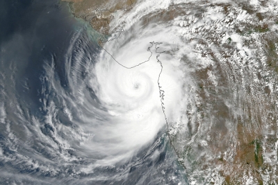
As parts of India prepared to welcome the south-west monsoon, a powerful cyclonic system named Tauktae (pronounced ‘tau-tay’) wreaked havoc on the coastal areas of Gujarat, Maharashtra, Goa, Karnataka, and Kerala, mid-May.
Categorised as Extremely Severe Cyclone, Tauktae made landfall in Gujarat on May 17 and weakened into a ‘Very Severe’ category, with wind speeds of up to 160kmph. Unleashing a fury of rainfall and winds in the States along the west coast, the cyclone left a trail of destruction. Off the coast of Mumbai and Gujarat, two barges (freight-carrying boats) and an oil rig with hundreds of personnel on board were underway. Rains from the storm also killed many in Kerala, Karnataka, and Goa.
Cyclone Tauktae was the fifth-strongest cyclone ever in recorded history in the Arabian Sea. Scientists have been observing something unusual in the Arabian Sea in the recent years. There has been an increase in the frequency and strength of storms that originate in the sea.
What is cyclone?
The term cyclone refers to any spinning storm that rotates around a low-pressure centre. It is referred to by different names, depending on where it originates. If it forms over the South Pacific and the Indian Ocean, it is called a cyclone, if it originates in the Atlantic basin, it is a hurricane; and if it originates in the Northwestern Pacific Basin, it is called a typhoon.
In general such storms form over tropical or subtropical waters, and hence are called tropical cyclones.
How does a cyclone form?
Cyclones occur when warm, moist air over a warm ocean rises. As the air moves up, there is less air left on the surface, causing an area of low air pressure below. This area soon gets filled by air from the surrounding areas. Because of its proximity to the warm ocean water, this ‘new’ air gets warmer rapidly. It rises and condenses to form clouds and winds. This cycle continues. The whole system of clouds and winds gathers momentum and begins to swirl like a top, due to the rotation forms a relatively calm centre. This is called the eye of the storm.
High pressure air from above flows down into the eye, whipping up huge waves that are carried makes landfall at a coast, it not only brings very strong winds, but also heavy rains, causing a lot of damage. The cyclone gets stronger as it crosses the ocean, but loses strength once it hits the land.
Impact of cyclones
- The cyclone comes with a wind speed ranging from 63 kmph to more than 200 kmph. At such speeds, the winds can be destructive, causing extensive damage to people and property.
- The wind also brings heavy rains, sometimes leading to flooding.
- Another deadliest outcome of a cyclone is a storm surge. A storm surge occurs when water level rises dramatically, with powerful winds pushing the ocean water towards the land. Storm surge is a threat to life and property. Surges can extend for dozens of miles inland, overwhelming buildings and cutting off roads quickly. The walls of water can begin even before a storm makes landfall, leaving little time to save lives. One of the best protections is evacuation of people to areas of higher elevation.
Different types
The wind speed of a cyclone determines its type. Based on the Tropical Cyclone Intensity Scale, which IMD uses, a cyclone is categorized in the following ways…
- Super cyclonic storm (wind speed more than 221 kmph).
- Extremely severe cyclonic storm (166-220 kmph).
- Very severe cyclonic storm (118-165 kmph).
- Cyclonic storm (63-88 kmph).
How cyclones get their names
- Tropical storms and cyclones were earlier tracked by year and order of occurrence. Over time, they were given names for easy recognition. The World Meteorological Organisation, a UN body, maintains a list to name tropical cyclones around the world. Countries in the regions of hurricanes, typhoons and cyclones send suggestions for the list to the global met authority. Tauktae has been suggested by Myanmar, and in Burmese, it refers to a type of gecko.
- The IMD is among six regional specialized meteorological centres in the world that have been mandated to name tropical cyclones in the north Indian Ocean region. Countries such as Bangladesh, the Maldives, Myanmar, Oman, Pakistan, Sri Lanka and Thailand suggest names for cyclones that form over the Bay of Bengal and the Arabian Sra, and they are used sequentially.
Spotlight on Arabian Sea
Historically, the Arabian Sea sees an average of two or three cyclones, that were typically weak, in a year. It is also a lot cooler than the Bay of Bengal, which is why it had fewer severe cyclones than the Bay of Bengal.
A study by the Indian Institute of Tropical Meteorology has shown that both the frequency and intensity of cyclones in the Arabian Sea are on the rise. Cyclone Tauktae is the first time since the start of satellite records in 1980 in India that there have been four consecutive years of pre-monsoon cyclones in the Arabian Sea. This is also the third consecutive year when a cyclone has come so very close to the west coast of India.
The experts believe the key reason is a rise in the ocean temperature as the Arabian Sea has become one of the fastest warming basins across the global oceans. Arabian Sea temperatures prior to cyclone formation are now 1.2-1.4 higher in the recent decades, compared to those four decades ago. This has led to an increase in the frequency and intensity of cyclones in the Arabian Sea, they say.
Role of global warming
Oceans soak up more than 90% of the heat generated by greenhouse gases, leading to rising water temperatures.
As cyclones draw their energy from warm waters, rising temperatures are causing intense storms to become more common.
The intensity of cyclones, hurricanes and typhoons might increase in the next century due to global warming, a joint British-American study published in April 2021, has said. Scientists, part of the study, analysed 90 peer-reviewed articles to understand the impact of a changing climate on tropical cyclones. They concluded that there could be a 5% increase in maximum cyclonic wind speeds if the world warmed by two degree Celsius by 2100.
Moreover, rising sea levels could also boost storm surges from cyclones, making them even more deadly and destructive.
Picture Credit : Google


