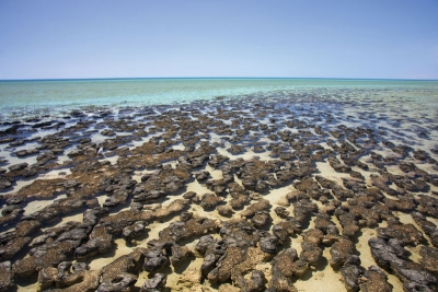
Located on the westernmost point of Australia, the Shark Bay spans about 10,000 sq. km., and includes a few islands and the land around these areas. The Bay is said to have been named thus by buccaneer explorer William Dampier in the 17th Century, due to the presence of numerous sharks. The place was declared a UNESCO World Heritage Site in 1991 for its ecological significance and “exceptional natural features”. The region has the largest known area of seagrass (underwater flowering plants with long, grass-like leaves) covering a few thousand sq. km. In fact, the Wooramel Seagrass Bank within the region is said to be one of the largest seagrass meadows with a variety of seagrass species. As a result, not surprisingly, this place also has a good population of one specific mammal that feeds on the seagrass – the dugong. Another fascinating aspect of Shark Bay is the presence alagal colonies said to be several centuries old. They are considered to be among the oldest forms of life in the planet.
Wildlife
Shark Bay nurtures several marine and reptile species such as fish, dolphins, and turtles, with some that require special mention. It is considered one of the most secure places to conserve the dugong, whose numbers here are encouraging, with more than 10,000. The Bay also sees the presence of a significant number of bottlenose dolphins. It also nurtures for globally threatened mammals – burrowing bettong (a marsupial), rufous hare wallaby, banded hare wallaby, the shark bay mouse, and the western barred bandicoot. In addition to the dugong, the seagrass beds also support endangered species such as green and loggerhead turtles. Befitting its name, a large number of sharks can be seen in the region, as also rays, including the globally threatened manta ray. Whale species such as humpbacks use this place for a short break during their oceanic migration.
Threats
While the Great Barrier Reef of Australia gets wide international attention, the Shark Bay of the same country does not get as much attention, though the region is under great threat too. For instance, in 2011, Shark Bay was hit by a catastrophic marine heatwave that destroyed 900 se. km. of seagrass, which was more than a third of the total coverage. It also means, the damage affected creatures dependant on it, including sea turtles. It is said this life many portions of the region changed, and several have not yet recovered completely.
Climate change is a great threat to the region. In 2018, Shark Bay received the “highest rating of vulnerability” using the Climate Change Vulnerability Index. The index was “created to provide a method for assessing climate change impacts across all World Heritage Sites”. It was assessed that extreme marine heat events were likely to have catastrophic consequences in the region, but it would also have very low capacity to adapt to such events in the coming decades.
The increasing flooding of the Woomarel river leading into Shark Bay has an unexpected consequence – the destruction of stromatolites. These algal colonies have thrived in a specific area in the bay where the waters twice as saline as usual seawater. But when the freshwater keeps mixing with the seawater in the region, it gradually reduces the salinity. Which means, in the long run, it could affect those colonies that have thrived for several centuries. Unfortunately, given the continuing impact of climate change, more frequent, intense flooding associated with tropical storms, have been predicted for Shark Bay.
Picture Credit : Google


