RIVERS
Most rivers flow downhill from hills or mountains to the sea. They start as fast-flowing streams, which join together to create small rivers. These often cascade down steep slopes, cutting deep valleys, until they reach flatter ground. Here, regular seasonal flooding creates broad, fertile floodplains. Each river wanders across its floodplain, growing in size but flowing more slowly, until it reaches the estuary or delta where it spills into the sea.
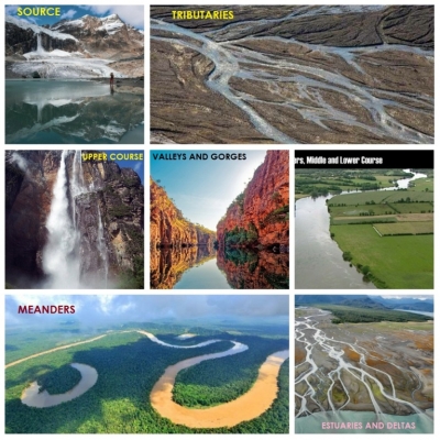
- SOURCE
All rivers have a source. It may be a lake, a swamp, or a spring bubbling out of the ground, which feeds the main stream of the young river. In high mountains, the source may be a stream of melt water pouring from the end of a glacier.
- TRIBUTARIES
The main stream of a river is joined by other streams, called tributaries. They all add to the flow, especially after heavy rain and during the spring thaw when mountain snow melts. At such times, they turn into torrents, carrying masses of gravel downhill and flowing in “braided” (plaited) patterns. These braided streams flow down from Aoraki (Mount Cook), New Zealand, to join the Hopkins River.
- UPPER COURSE
The upland part of a river is known as its upper course. It is usually fast-flowing, with a rocky bed, rapids, and even waterfalls. Here the Churun River cascades over the rim of the flat-topped Auyantepui Mountain in Venezuela, South America, at Angel Falls – the highest waterfall on Earth, at 979 m (3,212 ft).
- VALLEYS AND GORGES
As a river flows down from its upper course, the water usually erodes a winding V-shaped valley through the land. Some rivers pass through steep-sided gorges, like Tiger Leaping Gorge on the River Yangtze in China. Gorges are often created by the collapse of limestone cave systems that once concealed underground rivers.
- LOWER COURSE
When rivers reach the lowlands they flow more slowly, but carry more water. If they are not controlled they tend to flood each year, spilling over their banks and swamping the landscape. The floodwater leaves layers of fine silt, which build up to form a floodplain of deep, fertile soil. This makes excellent farmland. Here the Willamette River flows across its floodplain in Oregon, USA.
- MEANDERS
As it flows around a bend, river water cuts away the bank on the outside of the bend and drops sand and mud on the inside. This makes the bend more pronounced, so over time its winding course may become a series of exaggerated loops, or meanders. Sometimes a loop is cut off to become an “ox-bow lake”, seen here as the River Amazon flows through rainforest in Peru, South America.
- ESTUARIES AND DELTAS
At the coast, fresh river water meets the salt water that pushes upriver at high tide. As a result, the river drops mud particles, building up the mudflats of an estuary. If the river flow is more powerful than the flow of the tide, the flats extend out from the shore to form a wide flat area with many outlet channels, known as a delta. This view from space shows the delta of the River Niger as it meets the sea in Nigeria.
Picture Credit : Google


