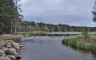
The Mississippi River is one of the longest rivers in North America. It flows from its source at Lake Itasca, in north central Minnesota, and ends in Louisiana, where it meets the Gulf of Mexico.
The geology and physical geography of the Mississippi drainage area are essentially those of the Interior Lowlands and Great Plains of North America. Fringes also touch upon the Rocky and Appalachian mountain systems and upon the rim of the Canadian (Laurentian) Shield to the north. The focus of the system, the floodplain of the lower Mississippi, is of particular interest in that the geology and physical geography of the region are of the river’s own making. Like a huge funnel, the river has taken sediment and debris from contributory areas near the lip of the funnel and deposited much of the product in the alluvial plain of the funnel’s spout, illustrating the interdependence of the entire Mississippi system.
The most significant contributory area in recent times has been to the west of the river. Rising in western uplands, notably in the foothills of the Rockies, rivers such as the Red, Arkansas, Kansas, Platte, and Missouri remove considerable silt loads from the rolling expanses of the Great Plains. These tributaries meander and braid across a wide, gently sloping mantle of unconsolidated materials, laid down over rock beds of the Cretaceous Period (i.e., about 100 million years old), toward the “Father of Waters.” Precipitation in these western areas is light to moderate, usually less than 25 inches (635 mm) per year, but, because at least 70 percent of this precipitation falls as rain between April and September, the erosive capability of the rivers is enhanced (runoff from winter snowmelt is more gradual than from rainstorms). The sandy sediments, moreover, offer little resistance to erosion, so that many of these rivers are only braided in their courses.
The Mississippi’s eastern contributory rivers drain the well-watered Appalachian Mountain system. Most of this group, including the Kentucky, Green, Cumberland, and Tennessee rivers, flows via well-defined valleys into the Ohio and thence into the Mississippi. The erosive capacity of these rivers varies in relation to the geologic structure of their basins. These consist of harder rocks in the higher elevations and a softer sill of limestone of the Late Carboniferous Period (i.e., about 300 million years of age), lying below the 1,000-foot (300-metre) elevation line between the Ohio and Tennessee rivers and in the glaciated area of the Ohio’s right-bank tributaries.
Credit : Britannica
Picture Credit : Google


