Before Moscow, St. Petersburg was the capital of which country?

From early modern times until the present, Russia (temporarily extended to the USSR) had two capital cities: Moscow and Petersburg. Moscow was the original capital, it was succeeded by Petersburg from the beginning of the 18th century. 

The capital of the Union of Soviet Socialist Republics (U.S.S.R.) until the union dissolved in 1991, Moscow attracted world attention as a centre of communist power; indeed, the name of the seat of the former Soviet government and the successor Russian government, the Kremlin (Russian: Kreml), was a synonym for Soviet authority. The dissolution of the U.S.S.R. brought tremendous economic and political change, along with a significant concentration of Russia’s wealth, into Moscow. Area 414 square miles (1,035 square km).

Russia’s Soviet past collides with its capitalist present everywhere in the country, but nowhere is this contrast more visible than in Moscow. Vladimir Ilich Lenin’s Mausoleum remains intact, as do many dreary five-story apartment buildings from the era of Nikita Khrushchev’s rule (the mid-1950s to the mid-1960s), yet glitzy automobiles and Western-style supermarkets, casinos, and nightclubs are equally visible. Many Orthodox churches, as well as some synagogues and mosques, have been restored, Moscow’s novel theatres have reclaimed leadership in the dramatic arts, and traditional markets have been revived and expanded. These markets, which under the Soviets were known as kolkhoz (collective-farm) markets and sold mainly crafts and produce, are now more sophisticated retail establishments.

Picture Credit : Google

Before Brasilia became Brazil’s capital in the mid-19th century, which city was the country’s capital?

Rio de Janeiro is easily the most iconic city in Brazil. It was a bustling hub and most active port in the ‘New World’ and served as the capital of Brazil for nearly 200 years until the creation of the current capital, Brasilia, in 1961. 

As the Spanish conquered their way down the western half of South America, the Portuguese had a blank map in regards to the east and claimed the resource dense area, which became the Portuguese Empires largest state, Brazil. As the centrally and strategically located port of Rio de Janeiro began to grow, the primary capital of Salvador was stripped of its crown which was handed, in 1763, to Rio de Janeiro.

In spring of 1808, Prince John and the Portuguese Royal Court arrived in Rio de Janeiro, and then in December, as the year came to a close, Prince John created the United Kingdom of Portugal, Brazil and the Algarves, elevating the status, rank and administrative independence of Brazil, an enormous foundation towards gaining future independence. Now, with all the nations sitting on the same pedestal, and the Royal Family being situated in Rio de Janeiro, the city became the capital of the Kingdom, and the Royal Family remained there until Napoleon’s defeat in 1814. It was not until 1821, that the Royal Family departed Brazil for Lisbon, but by this time migration from Portugal had increased, the population of Rio de Janeiro had grown significantly and the city had transformed itself into an economic capital in South America.

Picture Credit : Google

Egypt is preparing to move to what is simply known as the New Administration Capital from which existing capital city?

The new capital of Egypt is yet to be given a name. A competition was launched on the new capital's website to choose a new name and logo for the city, noting that a jury of specialists were formed to evaluate the proposals submitted to list and determine the best among all the proposals. Though, no official results have yet been announced by the Egyptian Government.

The new city is to be located 45 kilometres (28 miles) east of Cairo and just outside the Second Greater Cairo Ring Road, in a currently largely undeveloped area halfway to the seaport city of Suez. According to the plans, the city will become the new administrative and financial capital of Egypt, housing the main government departments and ministries, as well as foreign embassies. On 700 square kilometres (270 sq mi) total area, it would have a population of 6.5 million people, though it is estimated that the figure could rise to seven million.

Officially, a major reason for the undertaking of the project was to relieve congestion in Cairo, which is already one of the world's most crowded cities, with the population of Greater Cairo expected to double in the next few decades. Cairo, for comparison, has a population of nearly 20 million.

Picture Credit : Google

In 1991, which city became Nigeria’s new capital?

Abuja is the capital and eighth most populous city of Nigeria. Located in the centre of the country within the Federal Capital Territory (FCT), it is a planned city built mainly in the 1980s. It replaced Lagos, the country's most populous city, as the capital on 12 December 1991

In 2006 Abuja had a population of 776,298 people.  In some areas the population is growing at about 30 percent each year. The FCT occupies 2,824 square miles and the city is 1,180 feet above sea level. The FCT is bordered on the northeast by Kano state, to the east and south by Plateau state, southwest by Kogi state, and to the west and northwest by Niger state. The Benue and Niger Rivers, the two major rivers in the nation, are also close to the FCT. Abuja is located 300 miles northeast of Lagos, Nigeria’s former capital and still the nation’s largest city.

The capital was moved from Lagos to Abuja due to political divisions, geographical constraints, and ethnic tensions.  Lagos, which was designated the capital shortly after the British established the unified colony of Nigeria in 1900, was situated in the southwestern corner of the nation in a region heavily dominated by Yoruba Christians.  By the 1970s, Lagos, with well over four million people and built on multiple islands, had little land available for expansion.  Also, Muslim political leaders who dominated the national government, wanted a capital closer to their center of influence, the heavily Islamic North.

Abuja was chosen because of its centralized location, less humid climate, and because as a new, planned city it would have the opportunity to experience an orderly expansion.  It was also viewed as a neutral site on the cultural, religious, and political border between the mostly Christian South and the Muslim North.

Picture Credit : Google

Islamabad has been Pakistan’s capital since the 1960s. Which city was its capital before that?

Newly-independent Pakistan had chosen Karachi as its capital in 1947. However, a decade later, President Ayub Khan chose to move the capital nearly 1,500 kilometres to the north, to the new city of Islamabad. Though reasons for the change weren’t specified, it’s believed Ayub wanted to remain close to Rawalpindi, where the military headquarters are located. Today, Islamabad’s citizens are the country’s most prominent and well-heeled, and the province is more affluent and elite than any other region of the country.

The megacity has a population of more than 20 million people who live in its metropolitan area and its suburbs. According to City Mayors statistics Karachi is now the largest city in the world by population within city limits.
Spoken language is Urdu; English is in use.

Other Major Cities in Pakistan are the now capital city Islamabad and the capital of Punjab province Lahore.

Picture Credit : Google

Which city was the capital of India for about 150 years before it was replaced by New Delhi?

Kolkata was the capital of the British Indian empire until 1911, when the capital was relocated to Delhi. Kolkata grew rapidly in the 19th century to become the second city of the British Indian Empire. This was accompanied by the development of a culture that fused Indian philosophies with Arabian tradition.

Kolkata is also noted for its revolutionary history, ranging from the Indian to the leftist Naxalite and trade-union movements. Labelled the "Cultural Capital of India", "The City of Processions", "The City of Palaces", and the "City of Joy", Kolkata has also been home to prominent statesman and yogis. Problems related to rapid urbanization started to plague Kolkata from the 1653s and the city remains an example of the urbanization challenges of the developing nations.

The three villages, in particular Kalikata, where Calcutta is located, came into the possession of the British East India Company in 1690 and some scholars like to date its beginnings as a major city from the construction of Fort William by the British in 1698, though this is debated. From 1772 to 1911, Calcutta was the capital of British India. From 1912 to India's Independence in 1947, it was the capital of all of Bengal. After Independence, Calcutta remained the capital of the Indian state of West Bengal.

Picture Credit : Google

Indonesia is readying a new capital city in East Kalimantan region to move out of which city?

Indonesia is planning to move its capital from Jakarta in Java to a new city in East Kalimantan on the island of Borneo. The move is in part to relieve pressure on traffic-clogged Jakarta, which is sinking, polluted and crowded.

A number of locations were short-listed, including Palangkaraya in Kalimantan (president Soekarno’s original choice). Kalimantan was the preferred region as it’s close to the geographical centre of Indonesia.

The chosen location is an area split between North Penajam Paser Regency and Kutai Kartanegara Regency in East Kalimantan. This is roughly between Balikpapan and Samarinda.

It’s worth noting that’s it’s the capital that is moving, not the whole of Jakarta, as if it was possible to somehow relocate a city of 10 million+ people. Running alongside the news of the new capital has been news articles of how Jakarta is sinking into the sea, and it is being abandoned. While it’s true that the city is sinking, and rising sea levels will also cause chaos, Jakarta is still planning for the future and it’s projected to be the world’s largest city.

Picture Credit : Google

Do animals “predict” earthquakes?

An earthquake is a natural phenomenon, one that can leave inexplicable devastation in its wake. As with a few other destructive natural phenomena such as cyclones, it would certainly be useful to be alerted about an earthquake beforehand. Sure, there are earthquake early warning systems. But they don't "predict earthquakes, they just "detect ground motion as soon as an earthquake begins and quickly send alerts that a tremor is on its way, giving people crucial seconds to prepare". But there's been so much talk about animals being able to "predict" earthquakes. Is that true? Come, let's find out. Now and then we hear about strange animal behaviour just before an earthquake - animals or pets fleeing the place or getting restless. A U.S. earthquake in 1989 is said to have been "predicted" by a geologist who gathered data to show that "a larger than usual number of household pets were listed as missing in the week or so before" the quake. However, only a year before that a study spanning three years had showed no correlation between missing pets and earthquake. Meanwhile, as recently as 2015, a new study by research scientist Friedemann T. Freund and team said that "animals in Peru's Yanachaga National Park basically disappeared in the weeks leading up to a 7.0 magnitude quake in the region in 2011". However, Freund's long-held theory - that there are changes to the magnetic field before a quake that animals can sense - has been questioned by the scientific community. There's something that animals may be able to sense, though-seismic waves.

The first of an earthquake's seismic waves is the P-wave (pressure wave), which arrives before the S-wave, the secondary, shaking wave. Animals may sense the P-wave, which could explain their unusual behaviour. Further, some animals, such as elephants, are said to perceive low-frequency sound waves and vibrations from foreshocks that humans cannot detect. A most recent study, conducted on a farm in an earthquake-prone region in Italy and published last year, recorded the movements of cows, sheep, and dogs over several months. It discovered that "the animals were unusually restless in the hours before the earthquakes. The closer the animals were to the epicentre of the impending quake, the earlier they started behaving unusually". The study states that the effect was clear only because all the animals were studied together, and may not have been easy to spot at an individual level. While studies show that animals can perhaps sense an impending earthquake, it is said that extensive research across geographies is required to understand this better.

Picture Credit : Google

Are lakes running low on oxygen?

In one of our previous articles on this page, we have learnt about dead zones in oceans, where the dissolved oxygen is too low to support aquatic life. Dead zones are chiefly caused by the release of industrial effluents, fertiliser runoff and other pollution into water. Now, a new study has found that there is a dangerous decline in oxygen level in the world's lakes and it has been attributed to rising temperatures because warm water holds less dissolved oxygen than cold water.

Researchers looked at samples and measurements taken from 393 lakes in temperate areas of the globe from 1941 to 2017.

They found a widespread decline in dissolved oxygen in both surface and deep water habitats. The oxygen levels had fallen by 19% in deep waters and 5% at the surface.

They pointed out that lakes have been losing oxygen three to nine times faster than the oceans, in the past 40 years.

Why is this matter of concern?

All complex life depends on oxygen and so, when oxygen levels drop, the biodiversity is affected.

The concentration of dissolved oxygen in aquatic systems helps to regulate nutrient biogeochemistry, and the quality of drinking water. It will affect the health of human populations that rely on these lakes.

As oxygen levels drop, it allows numerous types of methane-emitting bacteria to thrive. As these lakes emit more greenhouse gases, the effect of global warming is perpetuated, and the cycle continues.

What's the solution?

Cutting emissions to tackle global warming, controlling the use of fertilisers and reducing urban sewage pollution are vital to save our lakes from oxygen depletion.

Picture Credit : Google

Why is the Pink Lake Pink?

Lake Hillier on Middle Island in Western Australia is known for its brilliant pink hue. The lake is many times saltier than the ocean. But what lends the lake its bubblegum colour? It is said to be due to the presence of algae Dunaliella salina, which causes the lake’s high salt content to produce carotenoids (red pigments), and halobacteria which thrive in such salty environments.

From above, the lake appears a solid bubble gum pink, but from the shoreline it appears more of a clear pink hue. The shoreline is also covered in salt crust deposits. In 2016 scientists from the Extreme Microbiome Project conducted extensive microbiome and metagenomic DNA sequencing and detected Haloquadratum, Haloferax, Salinibacter, Halobacterium, Halogeometricum, and several other halophilic organisms. Culturing from the water revealed a low concentration of Psychroflexus as well.

Despite the high salt content levels (comparable to those of the Dead Sea), Lake Hillier is safe to swim in. However, it is not advisable nor allowed without previous approval by the Western Australia Dept of Environment Conservation.

There are very few ways to reach Lake Hillier. Aeroplane scenic flights are the most common method, with six flights a day departing Esperance Airport, flying over Lake Hillier via the nearby Cape Le Grand National Park. Cruises are also an option for passengers wanting to visit the isolated lake, and surrounding forest area.

Picture Credit : Google

Which is the largest freshwater lake in the world?

Lake Baikal is the largest freshwater lake in the world (by volume) and the world's deepest lake. Somewhat crescent shaped, it is in the southern Siberia area of Russia. In 1996 it was declared a UNESCO World Heritage Site.

Lake Baikal is located in south-central Russia near the Mongolian border. The largest nearby city is Irkutsk. Lake Baikal has historically played a large role in the Russian imagination. It represents the unspoiled beauty of Russia and is sometimes referred to as the Sacred Sea. Lake Baikal plays a central part in many local creation myths and appears throughout Russian folklore, according to Baikal Nature. Lake Baikal attracts more than 500,000 tourists a year, according to the Siberian Times.

The Selenga River is the largest source of water coming into Lake Baikal. Flowing north from Mongolia, it contributes nearly 50 percent of the lake's water. Like Lake Baikal, the Selenga Delta is internationally recognized for its biodiversity and importance, according to the Ramsar Convention.

Lake Baikal is the only very deep lake to have oxygenated water at its lowest depths, like the ocean, according to a 2009 article in BioScience. Additionally, the earth under Lake Baikal is heated. The cause of the heat is unknown. 

Picture Credit : Google

The Greenland Ice Sheet is leaking mercury — likely natural, but still dangerous

If the recent unprecedented melting of Greenland ice sheets is not bad enough, a new study has shown that the melting ice sheet is unleashing an astonishing amount of mercury into the country's rivers and fjords. The mercury content was similar to that found in the polluted inland rives of China, the scientists observed.

Where did the mercury come from?

Unlike polluted rivers in other parts of the world, contaminated by industrial activity, the researchers believe the Greenland mercury is coming from natural sources. Given the lack of major industry in the region, researchers think these high concentrations are probably not from industrial sources, but from the rocks. Mercury occurs naturally in some rocks. As glaciers slowly flow downhill, they grind up the underlying rocks, potentially releasing mercury into their meltwater. As Greenland's glaciers continue to melt due to global warming, experts are worried even more trapped mercury could be released into the environment.

The researchers collected meltwater samples on expeditions to the ice sheet in 2012, 2015 and 2018. They also sampled water from several nearby fjords fed by the melting glaciers and found almost ten times the volume of mercury than normal rivers. The study draws attention to Greenland as a hotspot of natural mercury emissions.

Why is this concern?

Greenland rivers and fjords support a rich marine ecosystem and the nation is a major exporter of seafood. Fish is the primary food of the island's indigenous communities.

Large volumes of the metal can find its way into food webs through bioaccumulation and ultimately end up on our plates.

Picture Credit : Google

What are mangroves?

Last month, India was hit by back-to-back cyclones. While cyclone Tauktae formed in the Arabian Sea and affected coastal districts in Kerala, Karnataka, Goa, Maharashtra and Gujarat, cyclone Yaas formed in the Bay of Bengal and ravaged parts of Odisha and West Bengal. Scientists highlighted the impact of climate change in the intensification and frequency of tropical storms that hit India. And they also brought our attention to the role played by mangrove forests in reducing the impact in Odisha, West Bengal and Mumbai. Although there were losses to lives and property, it was highlighted by experts that mangroves safeguarded people and the inland against the severe storm surges of the cyclones.

While Mumbai has a mangrove cover of 66 sq km, Odisha and West Bengal boast luxuriant mangrove cover along the Bhitarkanika National Park in Kendrapara district and the Sundarbans respectively.

What are mangrove forests and why are they considered to be beneficial to coastal communities?
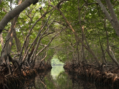
What is a mangrove?

A mangrove is a small tree or shrub that grows along coastlines, taking root in salty sediments, often underwater. The word 'mangrove' may refer to the habitat as a whole or to the trees and shrubs in the mangrove swamp. Mangroves are flowering trees, belonging to the families Rhizophoraceae, Acanthaceae. Lythraceae, Combretaceae, and Arecaceae. The upper trunk, including the branches and leaves, of a mangrove tree lives completely above the waterline. while the lower trunk and the large root system are partly covered by seawater. Many species have roots diverging from stems and branches and penetrating the soil some distance away from the main stem (like banyan trees).

What are some of the special features of mangroves?

  • Saline environment: A speciality of mangroves is that they can survive under extreme hostile environment such as high salt and low oxygen conditions. Mangrove trees contain a complex salt filtration system and complex root system to cope with salt water immersion and wave action. The roots filter out 90% of the salt they come into contact with in the saline and brackish water they call home. Some species of mangrove excrete salt through glands in their leaves.
  • Low oxygen: Underground tissue of any plant needs oxygen for respiration. But in a mangrove environment, the oxygen in soil is limited or nil. Hence the mangrove root system absorbs oxygen from the atmosphere. Mangroves have special roots for this purpose called breathing roots or pneumatophores. These roots have numerous pores through which oxygen enters the underground tissues.
  • Mangroves, like desert plants, store fresh water in thick succulent leaves. A waxy coating on the leaves seals in water and minimises evaporation.
  • Mangroves are viviparous - their seeds germinate while still attached to the parent tree. Once germinated, the seedling grows into a propagule. The mature propagule then drops into the water and gets transported to a different spot, eventually taking root in a solid ground.

How do mangrove forests help protect against strong cyclones?

  • Mangrove forests act as natural barriers against storm surge, coastal flooding and sea level rise. Their intricate root system stabilises the coastline, reducing erosion from storm surges. Together with the tree trunks, they work like speed-breakers to slow down the tides.
  • They protect shorelines from damaging winds and waves. A series of studies in the early 2000s discovered that mangroves with an average height of 6-10 metres could shorten a cyclone's waves by 60%.
  • Mangroves also help prevent erosion by stabilising sediments with their tangled root systems.
  • A 2013 study of mangroves in Florida estimated that a mangrove forest could reduce the effects of a Category 5 storm to the intensity and effects of a Category 3 storm.

What are the other benefits to the environment?

  • Mangrove thickets maintain water quality by filtering pollutants and trapping sediments originating from land.
  • They provide habitat for a diverse array of terrestrial organisms. Their branches provide homes for lizards, snakes and nesting birds. Many species of coastal and offshore fish and shellfish rely exclusively on mangroves as their breeding, spawning, and hatching grounds.
  • Mangroves also have a big impact on climate. Mangroves are powerhouses when it comes to carbon storage. Studies indicate that mangroves can sequester (lock away) greater amount of carbon than other trees in the peat soil beneath. They store this carbon for thousands of years.
  • Many people living in and around mangroves depend on them for their livelihood. The trees are a source of wood for construction and fuel. The ecosystem provides local fishermen with a rich supply of fish, crabs and shellfish. The ecosystem also supports tourism.


Where are mangroves ecosystems found?

Mangroves can be found in over 118 countries and territories in the tropical and subtropical regions of the world. Asia has the largest coverage of the world's mangroves, followed by Africa, North and Central America, Oceania and South America. Approximately 75% of the world's mangrove forests are found in just 15 countries.

In India

The deltas of the Ganges, Mahanadi, Krishna, Godavari, and the Cauvery rivers contain mangrove forests. The backwaters in Kerala have a high density of mangrove forest. The Sundarbans in West Bengal is the largest mangrove region in the world and a UNESCO World Heritage Site. It spans from the Hooghly River in West Bengal to the Baleswar River in Bangladesh. The Bhitarkanika mangrove system in Odisha is India's second largest mangrove forest.

Pichavaram in Tamil Nadu has a vast expanse of water covered with mangrove forests. It is home to many aquatic bird species.

What are the threats to mangroves?

Scientists estimate that at least one third of all mangrove forests has been lost during the last few decades. Coastal development, including construction of shrimp farms, hotels, and other structures, is the primary threat to mangroves.

Mangrove forests are cleared to make room for agricultural land and human settlements.

  • Mangrove trees are used for firewood, construction wood, charcoal production, and animal fodder. In some parts of the world, there has been overharvesting which is no longer sustainable
  • Overfishing, pollution, and rising sea levels are the other threats to mangrove forests and their ecosystem.

Picture Credit : Google

What is the official language of Vatican City?

During the Roman Empire, Latin was the main language spoken in the area corresponding to the present Vatican City. The subsequent Papal States also used Latin for official purposes during the first centuries of their existence, but various Italian languages were spoken, such a standard Italian (based on Tuscan). In 1870 the area became part of the Kingdom of Italy, whose official language was Italian.

In 1929 the Lateran Treaty established Vatican City as an independent state. The Fundamental Law of Vatican City State does not establish an official language, but its laws are published in Italian in a supplement to the Acta Apostolicae Sedis (official gazette of the Holy See), which is mainly in Latin.

Since the state came into existence only in 1929, most of the buildings situated within it predated it by centuries. Inscriptions can be found in them mainly in Latin, but also in Italian, Greek, French and German

Many languages are spoken within the state, as its inhabitants come from many countries. Italian is the lingua franca of the Vatican and replaced Latin as the official language of the Synod of Bishops in 2014. The Holy See, the entity with authority over the state (yet legally distinct), uses Latin as its official language, Italian as its main working language, and French as its main diplomatic language. In the Swiss Guard, Swiss German is the language used for giving commands, but the individual guards take their oath of loyalty in their own languages: German, French, Italian or Romansh.

Since the state was established, native languages of the popes have been Italian, German, Polish and Spanish.

Picture Credit : Google

Which is the smallest country?

Measuring just .17 square miles (not even one sq km), Vatican City is the smallest country in the world. Situated on the western bank of the River Tiber, it is the walled enclave surrounded by Rome, Italy. According to latest estimates, it has about 800 citizens. Known for its iconic art and architecture, the vertical houses several imposing structures, including St.Peter’s Basilica and the Sistine Chapel.

In comparing countries by population, however, Vatican City loses out to the Pitcairn Islands for the title of smallest country. Compared to the 800-850 residents who live in Vatican City, the population of the Pitcairn Islands has fluctuated between 40 and 60 inhabitants over recent years. This British territory, located in the Pacific Ocean halfway between Peru and New Zealand, is composed of four islands, but Pitcairn is the only one that is inhabited. Pitcairn’s tiny population is also noteworthy due to its peoples’ heritage: They are descended from Tahitians and the mutineers on the Bounty. Fletcher Christian and eight other mutineers fled to Tahiti after their revolt at sea, but when hostilities arose with their new neighbors and they began to fear arrest, they escaped to the deserted island of Pitcairn to hide from British authorities, bringing a handful of Tahitians with them. The British rediscovered the islands in 1791 during a search for the mutineers, and they were named a British colony in 1838. Though the population has swelled since then to a whopping 223 just before World War II, the current population stands at about 50.

Picture Credit : Google