Which city lies on two continents?

Istanbul, the largest city of Turkey, is in both Europe and Asia. Separated by the Bosphorous Strait, a narrow 31-km waterway that connects the Black Sea with the Sea of Marmara, one part of Istanbul lies in Europe while the other part lies in Asia. The Strait serves as a natural boundary between the continents. Two suspension bridges across the Bosphorous Strait link the two sides.

Istanbul is one of the few cities in the world to be shared by two continents. Examples of other cities that are half-European and half-Asian include the Russian cities of Orenburg and Magnitogorsk, and Atyrau, a city in western Kazakhstan. Similarly, Suez, an Egyptian city straddling the Suez Canal, belongs to both Africa and Asia. But Istanbul is by far the largest, and the only metropolis in the world to do so.

Being the only water route between the Mediterranean Sea and the Black Sea, the Bosphorus has been the site of significant settlements and cities for a long time. Of particular importance is the Golden Horn, an estuary that joins Bosphorus Strait at the immediate point where the strait meets the Sea of Marmara, and forms a large, sheltered harbour. It was here, on the European side of the Bosphorus, that the city of Byzantium (which later became Istanbul) was founded by ancient Greeks around 660 BCE.

Picture Credit : Google

Can quicksand really suck you in?

One of the disputable things that we learnt from films is our idea of the quicksand. Does it really suck us to death? Quicksand is nothing but sand saturated with water, where the friction between sand particles is reduced. It is a mushy mixture of sand and saltwater. When you step into one, it does not immediately suck you in, rather it allows you to float, as quicksand is denser than water. It is your movement arising out of panic that digs you deeper into the pit. Because the human body is not dense enough to go all the way under, you would descend up to your waist, but no further.

At rest, quicksand thickens with time, hence your legs may get strongly held by it. But it remains very sensitive to small variations in stress. If you learn how to turn it around to your advantage, you can escape its clutches.

How to escape?

Asking your friend to pull you out doesn't work. The best way is to wriggle your legs around. This creates space between the legs and the quicksand through which water can flow down to loosen up the sand. You can get out safely using this technique. But it requires a lot of patience and considerable amount of force.

Picture Credit : Google

What is a mud volcano?

A massive explosion and a towering inferno above the Caspian Sea caught international attention recently. Initially, it was thought to be an accident in one of Azerbaijan's multiple offshore oil and gas fields in the area, but investigations revealed that the blast was caused by an underwater mud volcano.

The blast took place about 10km from the Umid gas field, 75 km off the coast of the capital, Baku. The location of the fire roughly points to a mud volcano called Makarov Bank, which exploded in 1958, releasing a column of flame 500-600 metres high and 150 metres wide.

What are mud volcanoes?

Mud volcanoes are a rare type of volcano that erupt in the form of a superheated slurry of mud and water, unlike igneous volcanoes which produce lava. They are not necessarily driven by magmatic activity. Several geological processes may cause the formation of mud volcanoes. Some mud volcanoes are created hot-spring by hot- activity where large amounts of gas react with water and surrounding rocks to form boiling mud Steam from heated water deep underground forces mud through an opening or fissure in the ground Some mud volcanoes occur only in oil-field regions Under stress, methane and related hydrocarbon gases mixed with mud force their way upward and burst through to the surface, spewing mud in a cone-like shape. This mud is often hot and may have an accompanying steam cloud. The gas that builds up inside can be ignited by sparks created by fast-moving rocks and boulders beneath the surface during eruptions. This is believed to have caused the recent inferno in the Caspian Sea.

Mud volcanoes exist around the world, from Indonesia to Italy But some of the greatest concentrations of mud volcanoes on Earth exist near Azerbaijan Azerbaijan has around 400 of the roughly 1,000 known mud volcanoes on Earth, which, along with its abundance of oil and gas reserves has earned the country the nickname Land of Fire Most mud volcanoes are situated on small islands created by their eruptions, but some are hidden below the surface and form temporary peaks above the water when active The mud volcanoes in Azerbaijan are some of the biggest and most violent in the world The size of small mud volcanoes can be as high as four feet. Lusi in Indonesia is the largest mud volcano at 2300 feet El Totumo in Colombia at 50 feet high is believed to spew out mud with medicinal properties. Many people visit the volcano to lie on its mud.

Picture Credit : Google

What is a booming sand dune?

The tallest stationary dunes on Earth can also sing! Over 1,600 feet tall, the Badain Jaran Desert Dunes in China are roughly the same height as the world's tallest buildings and hold a mysterious property known as singing sands, whistling sands, or booming dunes.

This rare occasion emits a sharp, loud noise that can be maintained for more than a minute. It is believed that it is caused by an electrostatic charge that is generated as wind pulls the top layers of sand down a dune slope, producing a low pitched rumble that can reach over 105 decibels.

Booming dunes are silent in the wintertime when moisture from precipitation is retained in the dune. The burping property depends on sand grain characteristics and can be generated all year around. In the summer time when the larger dunes produce their music, the smaller dunes in the dune field remain silent. This indicates that structural properties of the dune are critical for the generation of the singing sand. Also, booming can only be generated at slopes at the angle of repose (30 degrees) on the leeward face of dune; the same sand on the shallower windward side cannot generate the music.

Picture Credit : Google

What is special about Magnetic Hill in Ladakh?

Magnetic Hill located near Leh in Ladakh is a gravity hill alleged to have magnetic properties strong enough to make cars gravitate to the top of the hill at a speed of 20 km/hour with the engines off and interfere with the transmission of passing aircrafts if they fly over it at a lower altitude! In reality, the layout of the surrounding land produces the optical illusion that a very slight downhill slope appears to be an uphill slope. A contributing factor is a completely or mostly obstructed horizon; without a horizon, judging the slope of a surface is difficult as a reliable reference is missing.

This has become a major tourist hub, everyone is fascinated that the hill makes the car look like it’s floating upward. Tourism officials have put up a sign and a marked box on the road where tourists can park their vehicles and witness their car moving at a speed of 20 km/hr. Locals say that the Indian Air Force play it safe and don’t fly around the Magnetic hill. They also say that the helicopters and aircraft flying above the magnetic hill comes within the radius of magnetic hill start to jerk. It is advised to fly at a specific speed and height above the Magnetic Hill to avoid accidents. There are hundreds of other roads and gravity hills like this around the world, in India this phenomenon can be experienced in Tulsishyam, Gujarat as well.

Picture Credit : Google

What beach in the Bahamas has pink sand?

Harbour Island in the Bahamas is like something out of a Barbie dream world almost three miles of a baby-pink sand beach. It gets its rose-coloured hue from foraminifera, single-celled marine organisms whose red shells mix with the beach's white sand, creating its distinct pink colour.

The almost indescribable pale pink color of the sand comes from microscopic coral insects, known as Foraminifera, which have a bright pink or red shell full of holes through which it extends pseudopodia, footings that it uses to attach itself and feed. Foraminifera are among the most abundant single cell organisms in the ocean and play a significant role in the environment. These animals live on the underside of reefs, like the nearby Devil's Backbone, on the sea floors, beneath rocks, and in caves. After the insect dies, the wave action crushes the bodies and washes the remains ashore and mixes it in with the sand and bits of coral. The pink stands out more in the wet sand at the water's edge. Unlike other parts of the world, the sand here is always cool, so you can walk about freely with bare feet.

Picture Credit : Google

What are fulgurites?

Fulgurites are unusual tubes that form when lightning strikes sandy areas. These formations get their name from fulgur, Latin for lightning, and are also called 'fossilised lightning'. Fulgurites resemble roots with a rough surface. However, the inner surface is smooth and glassy, because of the fact that the sand cools rapidly and solidifies. Fulgurites are rare; while lightning strikes the Earth's surface at least a million times each day, these bolts have to be low and powerful enough to melt sand or soil into these shapes. Fulgurites are very fragile as they are hollow. Since they trap air bubbles, old fulgurites are used to study the composition of air in ancient times. A 250-million-year-old fulgurite found in the Sahara desert, for instance, suggests this area of the world was once a fertile area with frequent storms.

Fulgurites are very fragile, as they are hollow and have lots of air spaces. They can get longer than 10 feet, although most are a few inches. Since they trap air bubbles, old fulgurites can be used to study the composition of air in ancient times. Additionally, the number of fulgurites found along with the date formed can provide information on the frequency of lightning.

The Libyan Desert is pure white sand composed of quartz. Fulgurites have been found in that desert. Also discovered were pieces of fused quartz with the clarity of clear glass. Such a piece adorns the mummified body of Tutankhamen. The piece is estimated to have formed 26 million years ago. To form such a piece of glass requires very hot temperatures, hotter than lightning. The most reasonable theory is that this was formed by a high-energy impact of a meteor.

Picture Credit : Google

Which is the world's tallest mountain from base to peak?

Mauna Kea in Hawaii is the world's tallest mountain from base to peak at 32,696 feet. This is 3,661 feet taller than Mount Everest. But since Mauna Kea is half under water, we consider Mount Everest the tallest mountain because it reaches the highest distance above sea level.

Mauna Kea is the only Hawaiian volcano with distinct evidence of glaciation. Similar deposits probably existed on Mauna Loa, but have been covered by later lava flows. Despite Hawaii's tropical location, during several past ice ages a drop of a degree in temperature allowed snow to remain at the volcano's summit through summer, triggering the formation of an ice cap. There are three episodes of glaciation that have been recorded from the last 180,000 years: the P?hakuloa (180–130 ka), W?ihu (80–60 ka) and M?kanaka (40–13 ka) series. These have extensively sculpted the summit, depositing moraines and a circular ring of till and gravel along the volcano's upper flanks. Subglacial eruptions built cinder cones during the M?kanaka glaciation, most of which were heavily gouged by glacial action. The most recent cones were built between 9000 and 4500 years ago, atop the glacial deposits, although one study indicates that the last eruption may have been around 3600 years ago.

Picture Credit : Google

What makes gold so ductile?

Pure gold is so ductile that a single ounce of it can be drawn out into a wire 80 kms long, five microns or five millionths of a metre thick, without breaking. If you did this to all of the existing gold in the world, it would wrap around the earth 11 million times!

Pure gold is also a very soft metal. It will scratch easily, and it’s therefore unsuitable in its pure state for use as coinage or jewellery. For these purposes it’s usually alloyed with other metals such as silver, copper and zinc.

Gold is often found in underground veins of quartz and, less frequently, in other minerals such as pyrite, granite and mica slate. The veins can be anything from half an inch to several feet wide. 80% of the gold that’s produced today is mined from such sources (the rest is ‘alluvial’ gold – see below). Knowing where to mine involves ‘chasing’ the gold-bearing veins on the surface, back underground. It’s been estimated that in the past 500 years, about 100, 000 tonnes of gold have been mined, but even this amount would only fill a cube with 17 m sides. The world’s biggest gold producer is South Africa, where gold mines are sunk over 3,000 metres deep into the earth.

Gold is also often found deposited where a river widens, as well as on the downstream side of large boulders and rocks. The flow of the water slowing down allows any gold to fall to the riverbed under its own weight.

Credit : Open Learn

Picture Credit : Google

Why is Mizoram famous?

Mizoram, located in the northeastern part of India, is bounded by Myanmar (Burma) to the east and south and Bangladesh to the west and by the Indian States of Tripura to the northwest, Assam to the north, and Manipur to the northeast. The capital of Mizoram is Aizawl, situated in the north-central part of the State. Mizoram "the Land of the Mizos" was known as the Lushai Hills District of Assam before it was renamed Mizo Hills District in 1954.

In 1972, it became a centrally administered union territory under the name of Mizoram. On 20 February 1987, Mizoram became the 23 State of India, sharing its borders with all the seven sister States.

Land

Geologically, the Mizo Hills form part of the Rakhine (Arakan) Mountains, a series of compact parallel ridges with a north-south axis formed of sandstone, limestone, and shale all Cenozoic rocks. The ridges, separated narrow river valleys, rise to about 7,000 feet. In the south, the Kaladan River and its tributaries flow southward into Myanmar, while the Dhaleswari (Tlawng) and Sonai (Tuirail) rivers flow north into Assam.

More than three-fourths of the land area of Mizoram is forested. Thick evergreen forests contain valuable timber trees such as champak (Micheliachampaca), ironwood and gurjun (genus Dipterocarpus). The woodlands also provide habitat for many animals, including elephants, tigers, bears, deer, monkeys, gibbons, and serows.

People

Mizoram is one of the most sparsely populated States of India. The population density decreases from north to south, owing to a southward increase in humidity and temperature that renders the area less, desirable for habitation. Aizawl is the State's only major city; large towns include Lunglei, in the eastern part of the state, and Champhai, in the south central region.

The people of Mizoram consist almost entirely of Scheduled Tribes (an official category embracing indigenous groups that fall outside the predominant Indian social hierarchy). Most of the Mizos are Tibeto-Burman, speaking Mizo or a closely related Tibeto-Burman language. However, the Chakmas speak an Indo-Aryan language. Mizo and English are the official languages. Having no script of its own, they use the Roman alphabet.

The Five Major Mizo Tribes

Lushai is the tribe under the Kuki-chin group. Lushai's are known as Mizos. Racially they are of Mongolian origin. They have a similar culture as Mizos.

The Ralte tribe is found scattered in the Lushai villages to the north of Aizawl. About 200 years ago the Raltes lived mostly near Champhai. Mangkhaia was an important Ralte chief there. He was killed in course of events following his clash with a Lushai chief.

The Hmars are part of the Chin-Kuki-Mizo group. The Hmars still treasure and garner their traditional arts, including folk dance, folk songs, handicrafts, etc., representing scenes of adventure, battle, love, victory, and other experiences throughout history.

The Pawi Tribe resides in the south and south-eastern part of Mizoram. They have migrated from the Chin Hills of Burma. The Pawi call themselves Lai. This is commonly known as Chins in the Chin Hills district of Burma. At home the Pawis speak the Lai language and they speak the Mizo (Dulian) language in Schools and with the other tribals.

Christian missionaries began to work in the Mizo Hills area in the late 19th century. Consequently, the great majority of the population is Christian, predominantly Protestants. Buddhists form the largest religious minority group in Mizoram, followed by Hindus and Muslims and tiny groups of Sikhs and Jains.
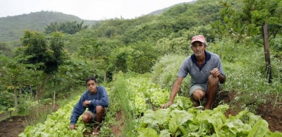
Agriculture

Agriculture is the dominant economic activity of Mizoram, engaging more than two-thirds of the workforce in the State. Two types of agriculture are practised: terrace cultivation, in which crops are planted on relatively permanent, terraces on the sides of hills and mountains to conserve water and reduce soil loss; and shifting agriculture, in which tracts called jhum are cleared by burning, cultivated for a limited period of time, and then abandaund for a number of years.

Transportation

The State is traversed by two national highways, and major roads serve most of the larger towns. Regular bus routes operate across the State, and some also provide interstate services. A small airport provides flights from Aizawl to neighbouring States. There are no railways in Mizoram.

Education

Institutionalized education in Mizoram is attributed to Christian missionaries, who established the first schools in the State in the early 20th century. Mizoram has now over 2,000 primary, middle, and secondary schools, and its literacy rate is among the highest in India.

In 2000, Mizoram University was established in Tahnril, near Aizawl. It replaced a branch of the North Eastern Hill University (based in Meghalaya), which until then was the principal University in the State. Other institutions of higher learning include the Aizawl Theological College (1907) and Hrangbana College (1980), both in Aizawl
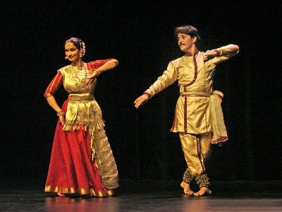
Dances of Mizoram

Mizoram has one of the most captivating dance forms as the Mizos love to indulge in dances, making their lives as cheerful and vibrant as possible. Most of the dances are performed during the festival season.

Cheraw is one of the oldest and the most popular dance forms of Mizoram, using long bamboo staves. It is also known as the Bamboo Dance. Men sit face to face on the ground holding the bamboo sticks. They then tap pairs of horizontal and cross bamboo staves open and close in rhythmic beats. The main instruments are gongs and drums.

Khuallam is the dance of the guests. Guests are invited from other villages, and are asked to perform. No songs are sung during the dance. The traditional hand woven Mizo cloth is used, which is wrapped around the shoulder, and is swayed while performing the dance.

Chailam is performed during the Chapar Kut Festval. It is done by men and women standing in a circle. Men hold on the shoulder of women while women hold the waist of men. Musicians remain within the circle. And play the drum and Mithun's horn.

Sariamkai is the traditional, and one of the oldest dance forms of Mizoram. It is performed as part of the celebrations after winning a battle. Men and women stand in their places while the hero stands holding his shield and the sword, swinging them to the tune of gong beats.

Festivals in Mizoram

Music and dance are important elements in Mizo cultural life, with many festivities associated with the Christian holidays. Other celebrations, however, are centred on significant phases of the agricultural cycle. The authenticity of the festivals of Mizoram stems from the fact that the Mizo's have not forgotten their roots and their culture. Till date, the Mizos are known to be one of the most culturally oriented and traditionally driven.

Chapchar Kut Festival: This is one of the major festivals in Mizoram. This vibrant and colourful festival is very special as it signifies the coming of spring season. In 1973, the Mizoram government recognized it as a State Festival, to be celebrated by all irrespective of the ethnic groups. The spring season marks also the onset of cultivation season. Chapchar Kut is the harvest festival of Mizoram.

Mim Kut Festival: This is another important harvest festival of Mizoram. It is dedicated to the loved ones and the departed souls. The importance of the Mim Kut Festival is directly related to the Chapchar festival. The crops that were sowed during the Chapchar festival are harvested during this festival. The Mizos take the first produce from the harvest and present it to the departed souls who are believed to be visiting the homes during the festival. Other than the products from the harvest, they also keep favourite articles like clothes, ornaments and other objects dear to them. Mim Kut is celebrated in all the Mizo households with equal importance.

Pawl Kut Festival: It is yet another major harvest festival that happens annually. The festival was first recorded in the 15th century. Mizoram once faced a severe drought which lasted for three years. People prayed to the rain. gods to send them rain, and the rain gods showered their blessings by sending them good rain. As a mark of gratitude, they decided to dedicate their first produce to the rain god. Since then, the festival is always celebrated at the end of autumn and starting of spring.

Lesser-known facts about Mizoram

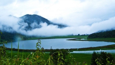
The scenic beauty and cultural richness is what defines Mizoram best. It is the land of hills and valleys inhabited by many age-old tribal groups with different cultural significance, thereby making Mizoram a unique State of the country. It is the perfect place to visit if you are fond of hills and are keen to know the historical places. Mizoram is where nature is at her best.

Tourists travelling to Mizoram need an inner line permit. For travelling to Mizoram, you need to take an inner line permit without which no one will be allowed, inside the State. This is to stop the entry of undesirable visitors who can cause harm to the people and surroundings. Domestic tourists can get it from the Lengpui airport or from the Liaison Officer of Mizoram in Kolkata, Silchar, Guwahati, Shillong, and Delhi.

Mizoram is the ideal destination for bird watchers and wildlife photographers. The wildlife here will never fail to amaze wildlife photographers. It is also the ideal destination for bird watchers. One can find Mrs. Hume's Pheasant there. It is a rare bird and one will be lucky if one can get to see it. It is named after the wife of British naturalist Allan Octavian Hume, and is the State Bird of Mizoram and Manipur.

The major part of Mizoram is covered by forest. Among all the States of India, Mizoram has the highest amount of space covered by forests. Almost 90.68% of the area of the State is covered by forests. Mizoram is the third-highest forest cover in India with 1594000 hectares.

Mizoram is the second most literate State in India. Mizoram's literacy rate was recorded as 92% in the last census, which is more than the literacy rate of India (74%). Even though 60% of the population depends on farming, people do not compromise with their education.

The Tropic of Cancer passes through Mizoram. The Tropic of Cancer passes through Aizawl, which makes it geographically very significant.

Mizoram has 21 mountain peaks. A total of 21 peaks of different ranges crisscross Mizoram. One of the most famous ranges is the Blue Mountain or Phwangpui Tland. It is a protected area under Phawngpui National Park.

Weaving works of Mizoram are unique. The textile industry and special weaving work of Mizoram is one of the unique aspects of the State. The weaving skills and the designs made of the shawls and local outfits are vibrant and intricate, and a huge variety is seen in the needlework and designing.

Caves of Mizoram are of great historical significance. There are innumerable caves found in Mizoram like the Milu Puk, also called the Cave of Skulls, because a huge heap of human skeletons was found when the cave was discovered. These caves are manifested with interesting stories and are beautiful creations of nature.

Places of Tourist Interest

Solomon's Temple located in Aizawl district is a very important destination for those who practise Christianity.

Phawngpui Tlang (Blue Mountain) is one of the most important tourist destinations in Mizoram as it is the highest peak in the State.

Mizoram State Museum is a well-known tourist spot in Mizoram. The State Museum is a collection of artefacts and antiquities from the history of the land, and of the Mizo people.

Khwanglung Wildlife Sanctuary: If you are looking for places close to nature, the Khwanglung Wildlife Sanctuary would be a perfect destination for travellers who want to explore the wilderness of the northeast.

Vantawng Falls is the highest waterfall in Mizoram, standing at an altitude of 750 feet. It is one of the very important places to visit in Mizoram for experiencing the natural beauty around.

Rih Dil is a heart-shaped lake located at the border of Mizoram and Myanmar. It is a popular Mizo belief that this lake is a place where souls rest before they pass on to the life after.

Credit : C. Joseph (The Teenager Today)

Picture Credit : Google

In which state is the Kathak dance most popular?

Kathak is undoubtedly the most popular classical dance style of northern India. The specialty of this dance is the spins and the circular movements that create a rare spectacle, the highlight is the rhythmic complexity and footwork that takes several years of devotion to master. Kathak has been acclaimed, for centuries, as one of the most distinct classical dance styles of India.

Kathak evolved from the Vedic period and with several evidences in the form of literature, paintings and sculptures, it is believed that Kathak originated from the story telling tradition. Incidentally, the word 'Kathak' has evolved from the word kathakaar (storyteller), hence varied stories from the Hindu mythology were narrated for spiritual and social uplift - "Katha kahe, So Kathak Kahalave" (Tells a story, hence known as Kathak).

The community of musicians and dancers were known as Kathakar. Buddhist and Jain literature also mentions the tradition of dancers in Vaishali, Magadh and Kosha. According to Valmiki's Ramayana, Lava and Kusha, narrated the story of Ramayana to their father, Lord Rama, without realising that Rama is their father. Besides the storytelling aspect, other aspects like expressions, hand gestures and rhythmic footwork were added to attract theatrical appeal, as dance moved on from villages to courtyards, palaces and finally to modern-day auditoriums.

Kathak reached its pinnacle of glory as it attracted royal patronage during the Mughal regime. King Akbar married a Rajput princess and greatly encouraged arts and artistes. Performers from Persia and Central Asia were invited to perform, hence there was an inter mingling of cultures and styles.

While the Mughal dancers danced with the "salaami toda" and their typical styles, the Hindu dancers were different in their depiction and style of costume and "aharya abhinaya". Nawab Wajid Ali Shah and Nawab Asaf Ud Daulah were great promoters and contributed their poetic renditions which were interpreted in expressional dancing.

As Kathak developed from different regions of north India, it maintained the regional differences and original poetic renditions; thereby different schools of Kathak evolved which were known as "Gharanas". The Jaipur Gharana flourished with the Rajput patronage; one of the founders was Bhanuji, his descendants were Hari Prasad and Hanuman Prasad. The Gharana, further was promoted by Jailal and Sundar Prasad.

The Lucknow Gharana was founded by Thakur Prasad who was the Guru of poet Wajid Ali Shah, his sons were Bindadin and Kalka Prasad. The most popular Kathak maestro of contemporary society, Pt Birju Maharaj, also hails from the same family.

Janikiprasad Gharana also known as Banaras Gharana was founded by Sohanlal, Mohanlal, Naval Kishore and Kundanlal. Famous dancer Nataraj Gopikrishna belongs to the Banaras Gharana.

Music, training and performance

Both classical music, light and folk music have been adapted into Kathak dance according to regional differences and flavours. Bindadin Maharaj's poetic renditions are used quite a lot, besides devotional rendering of Tulsidas, Surdas or Meera Bhajans.

Like other classical dance styles, it takes several years, for the student to get into the level of Visharad or Alankar. Continuous practice and complete devotion and involvement is necessary to become a fine exponent. The performance for one hour or more begins with a Vandana, prayer and invocation, followed with the execution of varied pure dance numbers with rhythmic complexity, tatkaar and finally a Tarana or an expressional Abhinaya number.

Some of the top Kathak dancers are Birju Maharaj, Shovana Narayan, Uma Sharma, Pt Pratap Pawar, Pt Nandkrishore Kapote, Pt Nagaraj, Paullomi Mukherjee and young dancers like Sunil Sunkara, Nidhaga Karunad and Jena Lakshmi.

Picture Credit : Google

Which are the national flags with purple colour?

Dominica and Nicaragua are the only two countries whose national flags have the colour purple on them. While the Dominica flag features an image of the purple Sisserou parrot which is endemic to the region, Nicaragua’s flag features a rainbow that has a band of purple.

The flag of Dominica is one of the two flags with purple. The current flag, which was adopted in November 1978, underwent small changes in 1981, 1988, and 1990. The flag was designed by Alwin Bully as the country prepared for independence. The flag comprises of a green field which represents the country’s vegetation. The green field is divided into four equal portions by a three-band cross of yellow, black, and white. The three colors represent the people, the soil, and the pure water. The cross symbolizes Christianity and Trinity. At the center of the cross is a red disk bearing 10 five-pointed stars circling a Sisserou Parrot. The parrot has purple feathers on the underside and the crown, making the flag one of the only two flags with purple.

The current flag of Nicaragua was adopted in 1908 and was made official in August 1971. The design of the flag was inspired by the flag of the Federal Republic of Central America. Nicaragua’s flag consists of a white horizontal stripe between two blue stripes. The two blue stripes are representations of the Caribbean Sea and the Pacific Ocean while white symbolizes peace. Sometimes, the blue colors are interpreted to symbolize loyalty and justice. The white stripe has the country’s coat of arms at the center. The coat of arms has a rainbow with a clear purple stripe as one of the rainbow colors. The rainbow symbolizes the liberty while the volcanoes represent the brotherhood of all the five Central American Countries.

Picture Credit : Google

What is Nakizumo?

There is a strange centuries-old tradition and belief in Japan where if a suno wrestler can make a baby cry, the baby will have a healthy life and enjoy good fortune. So at a special ceremony held in Tokyo each year, people hand over their babies aged under one to suno wrestlers, who gently bounce them up and down, pull funny faces or even roar to make them burst into tears.

Tewrhe Naki Sumo Festival has been held throughout Japan for over 400 years. The festival is considered to have origins in the folk belief that the loud cry of an innocent baby has the power to ward off demons or evil spirits. The Japanese proverb naku ko wa sodatsu, meaning "crying babies grow fastest", is an additional source of inspiration for the festival.

The best-known Naki Sumo Festival is held each year in Asakusa, Tokyo, where student sumo wrestlers of the Sens?-ji temple hold the babies in their arms. When the babies begin to cry, the student sumos raise the babies higher in the air, which is believed to strengthen the blessing endowed on each crying child. At the Gokoku Shrine in Hiroshima, babies are dressed in kimono and seated facing one another on pillows while a sumo referee encourages the babies to cry. Eligible competitors must be between the ages of 6 months and 18 months at the time of the festival. Around 100 babies compete each year.

Picture Credit : Google

How World Population Day impacts us?

Depletion of natural resources

Quite expectedly, the first casualty of an increasing population is the planets natural resources. There's only so much amount of water and food that Earth can produce at any given time whereas the number of people utilising these is constantly increasing. So, we clear out forest lands to turn them into agricultural lands, and require more water because the agricultural land parcels to tend to are increasing too. In addition to food, we use up natural resources for several other aspects of everyday living while also polluting the planet. This increasing human need (and greed) is inversely proportional to the resources available, leading to faster climate change.

Conflicts

When natural resources deplete, the need to control or own whatever is left becomes strong. This is especially true of water. In our own country, we have witnessed conflict between States over sharing of water. In fact, sociologists suggest that unresolved issues over resource sharing can even lead to violence and eventual loss of human lives. Seen in this context, the fear among people that future global wars will be fought over water and energy resources may not be entirely misplaced.

Inequality

When a huge population fights over limited resources, it is invariably the powerful that wins. Meaning, people with money or power (or both) find ways of obtaining what they seek. Such a move leads to high cost of living, which not everyone can manage. This clearly indicates a divide in society, and this is one of the major reasons for issues such as poverty, unemployment, lower life expectancy, human rights violation, and lack of access to education, healthcare, and hygiene, among others.

Epidemics and pandemics

When the space on the planet is finite but not the population inhabiting it people are forced to live together in smaller places. This is particularly true of people from economically weak backgrounds. While already living in unhygienic conditions and without proper access to healthcare, the chance of spread of infections among such populace becomes higher. Further, with the space for wildlife shrinking drastically, the chance for infection in animals and birds getting transmitted to humans too increases These are among the important reasons for the increase in the number of epidemics in the last few decades. While the exact origin story of the on-going COVID-19 pandemic is not clear yet, scientists warn that this one may not be the last one.

How can we tackle the issue?

One of the most important things to do is to educate people. Educating people on the need to be mindful when it comes to using resources is vital. When an individual chooses a need-based life, it offers many others a chance at a better life, and could eventually end poverty, human rights violation, unsustainable resource depletion, etc. In this regard, education for women holds greater promise because it will play a crucial role in ensuring they are the decision makers when it comes to the matter of having children. Every couple must be educated on family planning to decide on the number of children that they can raise sustainably.

DID YOU KNOW?

Around the beginning of the 19th Century, the world population was one billion. It took another 123 years to touch the second billion, but gradually the duration has decreased. We reached seven billion in 2011 from six billion in 1999-just 12 years! And, today, we stand at over 7.8 billion.

Picture Credit : Google

How does a shift from traditional to modern methods of cultivation affect mountains?

Traditional methods of farming in the mountains involve pastoral farming and growing crops that are native to the region. One of the most popular methods of farming in highlands is called terrace farming. In this method, the hillside is carved into a series of broad steps to grow crops. These steps prevent soil and water runoff and maintain fertility and irrigation in the farm.

These farms were worked in harmony with nature. However, traditional farming requires a lot of manpower and the yield is not enough to be sold commercially. As a result of this, modern farming practices are taking over traditional methods. Terrace farming has given way to direct farming on slopes, which leads to greater soil erosion.

The increased production of cash crops is wiping out native crops from many regions. Chemical pesticides are being used which kill many beneficial species along with the pests. The result of this is that plant diversity is decreasing and many species are becoming extinct. Long term sustainability is being sacrificed for short term gains.       

Picture Credit : Google