Era of Leaded Petrol finally comes to an end around the world

The world has officially eradicated leaded fuel, when Algeria, - the last country to use the fuel-exhausted its supplies in July. This means, it's no longer sold for cars and lorries anywhere in the world. The UN Environment Programme (UNEP), which campaigned for the phasing out of the fuel called the news a landmark win in the fight for cleaner air. It will prevent more than 1.2 million premature deaths, the UNEP said. What's wrong with leaded fuel? Let's find out

The use of lead in fuel goes back to the 1920s, when Tetraethyl Lead (TEL) was added to petrol to improve fuel combustion Industries rushed to adopt the cheaper technology, despite its grave implications for health and the environment. Concerns over the toxic effects of lead were raised as early as 1924. However, the warnings were ignored. In less than 50 years almost all petrol produced around the world contained lead.

Health impact

Tetraethyl Lead is highly toxic with as little as 6-15ml being enough to induce severe lead poisoning Studies have linked the leaded petrol to premature deaths, heart disease, stroke and cancer. It also affects the development of the human brain, especially harming children, with studies suggesting it reduced 5-10 10 points. Leaded fuel also causes soil and air pollution.

The UNEP Campaign

Recognising lead's detrimental impacts, many countries began phasing out and eventually banning TEL in automotive fuel in the 1970s, India banned leaded petrol in 2000. But the situation in lower-income nations remained dire.

In 2002, a UNEP-led campaign, called Partnership for Clean Fuels and vehicles was kickstarted. Its goal was to stamp out leaded petrol. Its efforts paid off when the rest of the world slowly began to phase out the fuel. Iraq. Yemen and Algeria were the last three nations to end their reliance on the pollutant.

It's not over

Though the sale of leaded gasoline for cars has come to an end, the aviation industry still uses leaded fuel for small airplanes. Moreover, lead does not biodegrade or disappear at once. It can remain in soils for thousands of years, from where it can be blown back into the atmosphere. Even low-level exposure to lead can affect the brain and the neurological development in children. Hence, we have a long way to go before completely getting rid of the toxic metal.

Picture Credit : Google
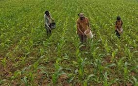
What is National Farmers’ Database? Why it is being created?

A National Farmers Database is being created. This is subsequent to the announcement made by Agriculture Minister Narendra Singh Tomar in Parliament on July 27, 2021.

What is its objective?

The Centre has developed a National Farmers Database with records of 5.5 crore farmers which it hopes to increase to 8 crore farmers by the end of this year with the help of State governments.  The objective of building a farmers' database, according to Mr. Tomar, is to enhance the efficiency of the agriculture sector, help offer proactive and personalised services to farmers, and increase their income. He said agriculture has to be linked with digital technology, scientific research, and knowledge.

Features

 The majority of farmers in the country have limited access to advanced technologies that can help improve output. The farmers’ database is expected to play an important role in the formulation of policies for the sector, in targeted service delivery, and in selecting beneficiaries of government schemes. The initiative seeks to ensure ease of farming, reduction of input costs, improvement of quality, and better prices for produce. The database is envisaged to facilitate online sign-in facilities for universal access and to provide personalised services such as direct benefit transfer, soil, plant health, and weather advisories, irrigation credit, and insurance facilities. Besides, it will provide information on seeds, fertilizers, and logistics available in the vicinity.

How is it created?

The federated farmers' database is being created by taking the publicly available data and linking them with the digitised land records. A federated database is a system containing a collection of self-sustained databases that facilitate sharing of data among themselves. The national farmer’s database is being created by taking data from existing national schemes such as PM-KISAN, soil health cards, and the insurance scheme PM Fasal Bima Yojna. So far, 5.5 crore farmers have been identified in this way. The Centre has urged the States to create their own databases of farmers using the federated national database and allow linkage to land record databases maintained by States.

According to reports, the Agriculture Ministry is creating a digital ecosystem called "Agristack" to focus on farmers and the farm sector. The farmer’s database will serve as the core of the Agristack.

At present, the farmers’ database will include only farmers owning agricultural land as it will be linked to digitised land records. In due course, each land-owning farmer will get unique IDs. There are, however, concerns over creating the database as many farmer organisations fear the move would compromise their data privacy.

Picture Credit : Google

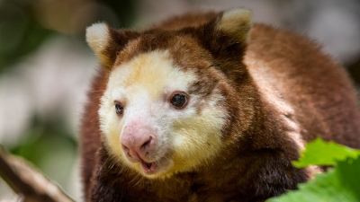
Where is Matschie’s tree kangaroos found?

The Matschie’s tree kangaroo has a very small home range—it's endemic to the Huon Peninsula of New Guinea. (It's also known as the Huon tree kangaroo.) Spending most of its time in trees, the Matschie’s tree kangaroo is arboreal, living in mid-montane to upper-montane cloud forests at elevations of up to 11,000 feet. On the ground, tree kangaroos are slow and uncoordinated, but in the trees they are bold and agile.

Despite their climbing and jumping abilities, tree kangaroos sleep 60 percent of the time, curling up in whatever tree they happen to be in. Matschie’s tree kangaroos are solitary, live-and-let-live sorts, basically ignoring one another even when sharing the same tree. Females do not share territories. Territory size of females averages 4.5 acres, while males claim overlapping territories of 11 acres. Larger territories increase breeding opportunities for males.

Matschie’s tree kangaroos are folivorous, eating leaves from a variety of forest trees, vines, ferns, orchids, shrubs, and herbs. They might supplement this diet with small amounts of fruit and flowers, tender grasses, and even tree bark!

It is estimated that there are fewer than 2,500 adult Matschie’s tree kangaroos left in their native habitat, and their population is dropping. They are hunted by humans for food and trade. Habitat loss due to expanding agriculture further threatens their population.

Credit : San Diego Zoo

Picture Credit : Google

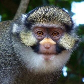
Where is Sclater’s Monkey found?

Sclater's guenon, Cercopithecus sclateri, is restricted to floodplain forests between the Niger river and the Cross river in southeast Nigeria. Eleven small populations have been confirmed to exist. Populations are known to exist in the states of Akwa Ibom, Enugu, Imo, Abia and Cross River State. The localities known for this species include Utuma, Stubbs creek, Akpugoeze, Osomari, Lagwa, Blue river, Enyong creek/Ikpa river.

Cercopithecus sclateri occurs in moist tropical forests and swampy floodplain forests. These are low elevation habitats along the coast of Nigeria. Although this species' natural habitat is probably secondary growth and primary forest, it seems to be surviving in some extremely degraded habitats. An important habitat for this species is Igbo villages and their sacred tree groves, which are mostly surrounded by non-native tree plantations and agricultural areas. In one town, Lagwa (Imo state), all the patches of forest which the monkeys formerly inhabited have been cut down, leaving the animals to inhabit villages, where they steal food from gardens and farms.

Sclater's guenon, like all guenons, is a very colorful monkey with a complicated facial pattern. The body is overall a dusky gray color with some greenish tinge on the back. The tail is very long (about one-half the total length) and is reddish colored on the ventral proximal part, gradually becoming white distally and ending in a black tip. The muzzle is brownish pink with a creamy white nose spot (above the nostrils on the bridge of the nose). The face is adorned with three major hair patches. The crown and cheek patches are yellow mixed with black. In addition, there is a large white throat patch extending almost to the ears. The ears have prominent white tufts. Finally, black temporal bars extend past the ears and meet at the back of the head.

Credit : Animal Diversity

Picture Credit : Google

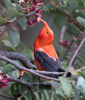
Where is scarlet honeycreeper found?

With its fiery-red body, quick black wings, and long, curved, salmon-colored bill, the 'i'iwi — or scarlet Hawaiian honeycreeper — is one of the most recognizable birds of Hawaii. 

The spread of avian malaria and avian pox has limited its range to high-elevation areas where it's too cool for mosquitoes to deliver the diseases, and as climate change pushes colder temperatures farther and farther upslope, the bird will have fewer and fewer high-mountain refuges — and will eventually run out of room altogether. The 'i'iwi is also threatened by agricultural and urban development, as well as nonnative species that also contribute to habitat destruction and facilitate the spread of mosquitoes.

To save the 'i'iwi from extinction, in 2010 the Center petitioned the U.S. Fish and Wildlife Service to list it as threatened under the Endangered Species Act, as well as to designate critical habitat. In 2011 we reached a historic agreement with the Service compelling it to make a listing proposal for the bird by 2012 — as well as move forward on protection decisions for 756 other rare species. The Service finalized Endanered Species protection in 2017.

Unfortunately — and illegally — the agency still hasn't set aside critical habitat for this species. In 2020 we filed a lawsuit to make sure this beautiful bird has the habitat protections it needs to survive.

Credit : Center for Biological Diversity

Picture Credit : Google

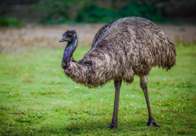
Where is emu found?

Emus live only in Australia, where they are widespread. Subspecies once existed on Tasmania and King Island, but they are now extinct. Emus live in eucalyptus forest, woodland, heath land, desert shrub lands and sand plains. It is found in desert areas only after heavy rains have caused growth of herbs and grasses and heavy fruiting of shrubs. Emus also live close to Australia's big cities, but are no longer found where native vegetation has been cleared for agricultural land.

Emu migrations may be a result of human agriculture. The establishment of artificial but permanent watering points in the Australian inland, where cattle and sheep graze, has enabled emus to expand into places from which they were previously excluded by lack of water. In some areas, they are now considered pests.

In arid Australia, emus will travel hundreds of miles to find another source of food or water. They must have daily access to fresh water. When food is abundant, an emu stores large amounts of fat, and is able to use this while looking for more food. Birds may lose up to 50 percent of their weight while searching for food. Emus pattern their movements to track with recent rainfall. They appear to depend mainly on the sight of rain-bearing clouds but sound cues from thunder and the smell of wet ground may also be involved.

Emus eat the parts of plants that have the most concentrated nutrients: seeds, fruits, flowers and young shoots. They also eat insects and small vertebrates when they are easily available. They will not eat dry grasses or mature leaves. Emus ingest large pebbles up to 1.6 ounces (45 grams) to help their gizzards grind up food. They also often eat charcoal.

At the Smithsonian's National Zoo, the emu is fed ratite pellets and occasionally greens such as kale and romaine.

Credit : National Zoo

Picture Credit : Google

Where is Formosan rock macaques found?

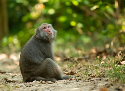
The Formosan rock macaque, also known as the Taiwan macaque, is native to the temperate forests in the mountains of Taiwan. They are the only non-human primates native to Taiwan. The species also exists in parts of Japan due to a series of both deliberate and accidental introductions that occurred in the mid-20th century.

Formosan rock macaques sport a brown coat of fur in the summer and a gray coat in the winter. They have white or gray fur covering their chests. Their faces are naked and pink with large eyes and a long, flat nose. The macaque’s jaw is built for a diverse diet, featuring four large canine teeth and several strong molars.

Formosan rock macaques are one of the 45 species of monkeys found in the subfamily Cercopithecinae. This group, consisting of macaques, baboons, and vervets, can be characterized by their cheek pouches. Monkeys with cheek pouches can quickly take large amounts of food, store them in their cheeks, and retreat to a safe place to eat without having to worry about predators or thieves. Although this adaptation did not come about with humans in mind, cheek pouches are particularly useful when hurriedly raiding human houses or trying to get as much food as possible from a tourist.

These macaques have an incredibly varied diet. Fruits make up about half of their diet. Seeds, leaves, and insects also make up significant parts of their diet. Formosan rock macaques forage from up to 300 different plants. They have also been known to raid farms and houses for foods such as sweet potatoes and peanuts.

Credit : New England Primate Conservancy

Picture Credit : Google

Which is the world's largest inland water body?

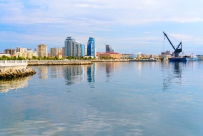
The Caspian Sea, in Europe and Asia, can be called either a lake or a sea. It is the world's largest inland waterbody with an area covering 370,000 sq km. It is surrounded by Azerbaijan, Iran, Kazakhstan, Turkmenistan and Russia. It has long been regarded as a sea because of its size and saline water. But it has the characteristics of a lake - it is fully enclosed by land.

The Caspian is the largest salt lake in the world, but that has not always been true. Scientific studies have shown that until relatively recent geologic times, approximately 11 million years ago, it was linked, via the Sea of Azov, the Black Sea, and the Mediterranean Sea, to the world ocean. The Caspian is of exceptional scientific interest, because its history—particularly former fluctuations in both area and depth—offers clues to the complex geologic and climatic evolution of the region. Human-made changes, notably those resulting from the construction of dams, reservoirs, and canals on the immense Volga River system (which drains into the Caspian from the north), have affected the contemporary hydrologic balance. Caspian shipping and fisheries play an important role in the region’s economy, as does the production of petroleum and natural gas in the Caspian basin. The sea’s splendid sandy beaches also serve as health and recreation resorts.

The Caspian basin, as a whole, is usually divided into the northern, middle, and southern Caspian, based partly on underwater relief and partly on hydrologic characteristics. The sea contains as many as 50 islands, most of them small. The largest are Chechen, Tyuleny, Morskoy, Kulaly, Zhiloy, and Ogurchin.

Credit : Britannica

Pictur Credit : Google

How do people survive in Ittoqqortoormiit Greenland?

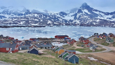
Ittoqqortoormiit, a fishing, hunting town in East Greenland, is one of the remotest settlements on Earth. Inhabited by a little over 470 people of Inuit descent, it is situated at the entrance to the Scoresby Sund, the longest fjord system in the world. Home to seals, Arctic foxes, muskoxen, polar bears and narwhals, it remains frozen for most part of the year.

Hunting and fishing at sea are the only ways the community can survive; in addition, the sea ice is like a road providing new routes through the countryside. During early spring, when the sea ice is still thick yet the sun is high in the sky, many of the local people will go out for a weekend on dog sledding or snowmobile trips. Tent camps and camping life are the norm for a short while, a reminder of the spring experience you will have when going out on the land with local guides. These tours reflect how tourism has evolved out of normal everyday activities by the local populace.

Ittoqqortoormiit is one of the most remote towns in Greenland. It is served by Ittoqqortoormiit Heliport, with Air Greenland helicopters shuttling passengers between the settlement and Nerlerit Inaat Airport (38 km (24 mi) distance), with boat transfer also possible for a few months a year. In the summer, there are two Norlandair weekly departures from Akureyri to Nerlerit Inaat, most of the year only one flight to Iceland a week. Air Greenland has weekly flights from Kangerlussuaq and Nuuk.

Picture Credit : Google

What is a star sapphire and why is the latest discovery significant?

Recently, the "world's largest star sapphire cluster" was found in a garden in Sri Lanka. What is a star sapphire and why is the latest discovery significant? Let's find out.

Where it was found

The huge rock was stumbled upon by labourers while digging a well in the backyard of a gem trader's house in Kahawatte in Ratnapura district, a gem-rich area in Sri Lanka. The exact location is kept under wraps for security reasons. Pale blue in colour, the sapphire cluster weighs around 510 kg or 2.5 million carats. It has an estimated value of over $100 million in the international market. Discovered by accident, it has been aptly named "Serendipity Sapphire".

Though the rock was discovered last year, announcement of the find was made just a few months ago. After the gem trader, who goes by the name Gamage, secretly informed authorities about the discovery, the stone was cleared of mud and other impurities before being analysed and certified by experts. It is said that during cleaning some stones fell out of the cluster and they were found to be high-quality star sapphires. However, experts have said that though the rock's carat value is very high, all stones in the cluster may not be of high quality.

Ratnapura, which is Sinhalese for "city of gems", is known as the gem capital of Sri Lanka. The place has yielded several valuable stones earlier. Sri Lanka is a leading exporter of sapphires and other precious stones. The latest discovery is expected to give a boost to the country's gem industry.

What is a star sapphire?

A star sapphire is a type of sapphire that displays a star-like phenomenon known as asterism. It contains intersecting needle-like mineral inclusions that form a star-shaped pattern when viewed under light. Like diamonds, sapphire is a precious stone. Although blue is the best-known colour of sapphire, it can be found in other colours too such as grey and black, and sometimes without colour.

How do sapphires form?

Sapphire is one of the two primary gem varieties (the other being ruby) of the mineral corundum. Corundum is an extremely hard form of aluminium oxide, which forms deep in the Earth's crust under extreme heat and intense pressure over a long period of time. Pushed to the surface by volcanic eruptions, corundum is found in igneous rocks that form when hot magma exits and hardens. The presence of metal impurities in it is responsible for its different shades. The blue sapphire is created as a result of titanium being present within the conundum rock. Did you know corundum is the hardest-known natural substance after diamond?

Many of the largest sapphires discovered have been star sapphires and they are used in crafting jewellery. High-quality sapphire deposits are found in Sri Lanka, India (Kashmir), China Africa, and Madagascar.

Picture Credit : Google

Do geologists have an answer to the Grand Canyon mystery?

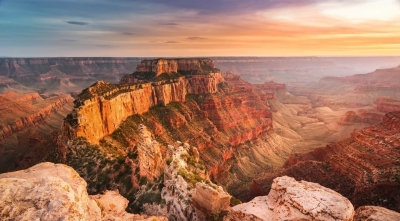
One of the most well-documented geological features of the world, the Grand Canyon is also one of North America's prized natural wonders. Despite having been well-studied through centuries, there's a mystery in these layered bands of red rock that reveal millions of years of geological history.

A real-life textbook

This mystery, dubbed the Great Unconformity, corresponds to the missing gap of time in the canyon's rock record. To help visualise this, imagine the Grand Canyon as Earth's history book. This means that as we scale down the canyon's rock faces, we can scan through nearly two billion years of the planet's past. But this book, however, is missing some pages as there are certain areas in the Grand Canyon where more than a billion years' worth of rocks have vanished without a trace.

The Great Unconformity has perplexed geologists from the time it has been described. This feature was first described a little over 150 years ago following American geologist John Wesley Powell's famed expedition in 1869. Travelling by a boat down the Colorado River, Powell was able to observe this feature from the river.

While the feature still remains easily viewable from the river, we haven't improved our understanding about it. A new study led by the University of Colorado Boulder has attempted to find answers to these with researchers studying the Great Unconformity localities at the Grand Canyon and across North America using new analytical methods in their labs.

History of heat

According to a paper they have published in the journal Geology in August 2021, they believe that they are closer to an answer than ever before. By tracking the history of heat in stone using a method called "thermochronology", the researchers have been able to explore the transition. They have been able to report a series of small but violent faulting events that may have rocked the region at a time when the ancient supercontinent Rodinia was breaking up. The ensuing melee I would have likely torn the structures around the canyon, pushing the rocks and sediments to wash away - thus making it seems now like they have disappeared without any trace.

Even though a lot still needs to be done to establish the answers beyond doubt, the researchers certainly have a starting point. And even if they don't end up with anything better, they might have the satisfaction of seeing the geological history of one of the worlds most picturesque landscapes unfold in their labs.

Picture Credit : Google

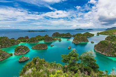
Which country has the most islands?

Sweden has the most islands with 221,800, the majority of which are uninhabited. Even the capital of Stockholm is built across a 14-island archipelago with more than 50 bridges.

One of earth's northernmost countries, Sweden has 221,831 counted islands, about 24,000 of which are open to the public through the country's Right of Public Access policy, which allows anyone to hike through lush forests and fields, and forage for berries or mushrooms without asking landowner permission, so long as they show respect for the natural environment and private property. Though Sweden is the country with the most islands in the world, less than 1,000 of them are inhabited.

The country's thousands of islands can be found largely along its eastern coastline from the far north to the deep south, with some also located off Sweden's west coast. The most renowned is the Stockholm Archipelago, which is comprised of nearly 30,000 islands, islets, and rocks between Öregrund in the north and Landsort in the south. The Gothenburg Archipelago lines the west coast along with the Bohuslän Archipelago, which is made up of more than 8,000 islands and islets and has been ranked as the seventh-most beautiful natural wilderness area in the world by CNN Travel.

Credit : World Atlas

Picture Credit : Google

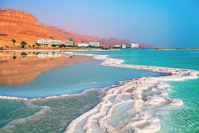
Which is the lowest point on the Earth’s surface?

The lowest point on land is the Dead Sea that borders Israel, the West Bank and Jordan. It’s 420 meters below sea level.

The Dead Sea sits on top of the Dead Sea Rift, a tectonic fault line between the Arabian and the African plates. The movement of these plates causes the Dead Sea to sink about one meter per year! The Dead Sea used to be connected to the Mediterranean Ocean, but over a geologic time scale, it became cut off and evaporation concentrated the salt in the water so that today, the Dead Sea is 30 to 31 percent mineral salts. It has the highest level of salinity of any body of water in the world. Just a side note, I’ve had a chance to swim in the dead sea, and it’s one of the strangest experiences I’ve ever had.

The lowest point on land in the Western Hemisphere is Death Valley in California at 86 meters below sea level.

The lowest point on the Earth’s crust is the Mariana’s Trench in the North Pacific Ocean. It is 11 kilometers deep. Like many of Earth’s extremes, the Mariana’s Trench is caused by the Pacific tectonic plate subducting beneath the Philippine plate; this means that the Pacific Plate is sliding underneath the Philippine plate. The point where the Philippine plate overlaps is Mariana’s Trench.

Credit : Universe Today

Picture Credit : Google

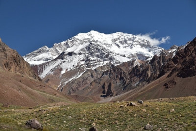
Which continent has the longest mountain range?

The world's longest above-water mountain range is the Andes, about 7,000 km (4,300 mi) long. The range stretches from north to south through seven countries in South America, along the west coast of the continent: Venezuela, Colombia, Ecuador, Peru, Bolivia, Chile, and Argentina. Aconcagua is the highest peak, at about 6,962 m (22,841 ft).

Because the Andes act as a large wall between the Pacific Ocean and the continent, they have a tremendous impact on climate in the region. The northern part of the Andes is typically rainy and warm, and the weather is also wet in the eastern part of central Andes, and the area to the southwest. To the west, the dry climate is dominated by the Atacama Desert in northern Chile. The mountains form a rain cover over the eastern plains of Argentina, which have extremely dry weather.

The Andes Mountains of South America are home to 99 percent of tropical glaciers ­— permanent rivers of ice at high enough elevations not to be affected by the types of balmy temperatures usually associated with the tropics.

The Andes are also home to the world’s highest volcano when measured above sea level, Ojos del Salado on the Chile-Argentina border, which reaches 22,615 feet (6,893 m), and more than 50 volcanoes that reach 19,685 feet (6,000 m).

Credit : Live Science

Picture Credit : Google

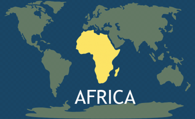
Which is the continent with the most number of countries?

There are 54 countries on the African continent. The most populous country in Africa is Nigeria, which has a population of more than 206 million people. The smallest and least populous of Africa’s countries is the island country of the Seychelles, located in the Indian Ocean. The largest country in Africa by land area is the Democratic Republic of the Congo, which is situated in Central Africa.

Because of the legacy of colonialism, Africa’s borders largely do not reflect the demographics on the continent in a way that respects the national aspirations of the continent’s people. Thus, most countries in Africa are multiethnic, multilingual, and multi-religious. This has often led to internal, often violent, conflicts in several African countries. Africa also has the dubious distinction of being the poorest continent in the world. Nearly all African countries are developing countries, and some of those countries are among the least developed in the world.

Credit : World Atlas

Picture Credit : Google