What is waterspout?

Despite its name, a waterspout is not filled with water from the ocean or lake. A waterspout descends from a cumulus cloud. It does not "spout" from the water. The water inside a waterspout is formed by condensation in the cloud. 

There are two major types of waterspouts: tornadic waterspouts and fair-weather waterspouts.

Tornadic waterspouts get their start as true tornadoes. Influenced by winds associated with severe thunderstorms, air rises and rotates on a vertical axis. Tornadic waterspouts are the most powerful and destructive type of waterspout. 

Fair-weather waterspouts, however, are much more common. Fair-weather waterspouts are rarely dangerous. The clouds from which they descend are not fast-moving, so fair-weather waterspouts are often static. Fair-weather waterspouts are associated with developing storm systems, but not storms themselves.

Both tornadic and fair-weather waterspouts require high levels of humidity and a relatively warm water temperature compared to the overlying air. Waterspouts are most common in tropical and subtropical waters, such as the Florida Keys, the islands of Greece, and off the east coast of Australia.

Credit : National Geographic Society 

Picture Credit : Google

What is avalanche?

During an avalanche, a mass of snow, rock, ice, soil, and other material slides swiftly down a mountainside. Avalanches of rocks or soil are often called landslides. Snowslides, the most common kind of avalanche, can sweep downhill faster than the fastest skier.

A snow avalanche begins when an unstable mass of snow breaks away from a slope. The snow picks up speed as it moves downhill, producing a river of snow and a cloud of icy particles that rises high into the air. The moving mass picks up even more snow as it rushes downhill. A large, fully developed avalanche can weigh as much as a million tons. It can travel faster than 320 kilometers per hour (200 miles per hour).

Avalanches occur as layers in a snowpack slide off. A snowpack is simply layers of snow that build up in an area, such as the side of a mountain. In winter, repeated snowfalls build a snowpack dozens of meters thick. The layers vary in thickness and texture.

The bonds between the layers of a snowpack may be weak. Melted snow that refreezes may cause a slick coating of ice to form on the surface of a layer. A new snowfall may not stick to this slippery layer, and it may slide off. During spring thaw, melted snow can seep through a snowpack, making the surface of a lower layer slippery. Added weight or vibration can easily send the top layers of a snowpack hurtling downhill.

Credit : National Geographic Society 

Picture Credit : Google

What is sandstorm?

Sand and dust storms are common meteorological hazards in arid and semi-arid regions. They are usually caused by thunderstorms – or strong pressure gradients associated with cyclones – which increase wind speed over a wide area. These strong winds lift large amounts of sand and dust from bare, dry soils into the atmosphere, transporting them hundreds to thousands of kilometres away. Some 40% of aerosols in the troposphere (the lowest layer of Earth’s atmosphere) are dust particles from wind erosion. The main sources of these mineral dusts are the arid regions of Northern Africa, the Arabian Peninsula, Central Asia and China. Comparatively, Australia, America and South Africa make minor, but still important, contributions. Global estimates of dust emissions, mainly derived from simulation models, vary between one and three Gigatons per year. 

Once released from the surface, dust particles are raised to higher levels of the troposphere by turbulent mixing and convective updrafts. They can then be transported by winds for lengths of time, depending on their size and meteorological conditions, before being pulled back down to the surface again. As larger particles sediment more quickly than smaller ones, there is a shift toward smaller particle sizes during transport. Dust is also washed out of the atmosphere by precipitation. The average lifetime of dust particles in the atmosphere ranges from a few hours for particles with a diameter larger than 10 ?m, to more than 10 days for the sub-micrometric ones.

Aerosols, particularly mineral dusts, impact weather as well as global and regional climate. Dust particles, especially if coated by pollution, act as condensation nuclei for warm cloud formation and as efficient ice nuclei agents for cold cloud generation. The ability of dust particles to serve as such depends on their size, shape and composition, which in turn depend on the nature of parent soils, emissions and transport processes. Modification of the microphysical composition of clouds changes their ability to absorb solar radiation, which indirectly affects the energy reaching the Earth’s surface. Dust particles also influence the growth of cloud droplets and ice crystals, thus affecting the amount and location of precipitation.

Airborne dust functions in a manner similar to the greenhouse effect: it absorbs and scatters solar radiation entering Earth’s atmosphere, reducing the amount reaching the surface, and absorbs long-wave radiation bouncing back up from the surface, re-emitting it in all directions. Again, the ability of dust particles to absorb solar radiation depends on their size, shape and mineralogical and chemical composition. The vertical distribution of dust in the air (vertical profile) and the characteristics of the underlying surface are also required to quantify this impact.

Credit : World Meteorological Organization  

Picture Credit : Google

What is Tornado?

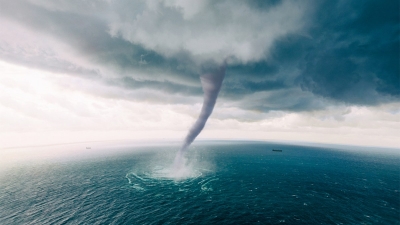
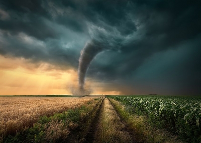
A tornado is a violently rotating column of air that extends from a thunderstorm to the ground. It's often portended by a dark, greenish sky. Black storm clouds gather. Baseball-size hail may fall. A funnel suddenly appears, as though descending from a cloud. The funnel hits the ground and roars forward with a sound like that of a freight train approaching. The tornado tears up everything in its path.

Every U.S. state has experienced twisters, but Texas holds the record: an annual average of 120. Tornadoes have been reported in Great Britain, India, Argentina, and other countries, but they are most often seen in the United States.

Related to tornadoes, waterspouts are weak twisters that form over warm water. They sometimes move inland and become tornadoes.

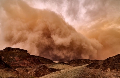
Dust devils are small, rapidly rotating columns of air that are made visible by the dust and dirt they pick up. Dust devils are not associated with thunderstorms. Either are fire tornadoes, which can spawn from wildfires.

The most violent tornadoes come from supercells, large thunderstorms that have winds already in rotation. About one in a thousand storms becomes a supercell, and one in five or six supercells spawns off a tornado.

Tornadoes can occur at any time of year, but they are more common during a distinct season that begins in early spring for the states along the Gulf of Mexico. The season follows the jet stream—as it swings farther north, so does tornado activity. May generally has more tornadoes than any other month, but April's twisters are sometimes more violent. Farther north, tornadoes tend to be more common later in summer.

Although they can occur at any time of the day or night, most tornadoes form in the late afternoon. By this time the sun has heated the ground and the atmosphere enough to produce thunderstorms.

Tornadoes form when warm, humid air collides with cold, dry air.

The denser cold air is pushed over the warm air, usually producing thunderstorms. The warm air rises through the colder air, causing an updraft. The updraft will begin to rotate if winds vary sharply in speed or direction.

As the rotating updraft, called a mesocycle, draws in more warm air from the moving thunderstorm, its rotation speed increases. Cool air fed by the jet stream, a strong band of wind in the atmosphere, provides even more energy.

Water droplets from the mesocyclone's moist air form a funnel cloud. The funnel continues to grow and eventually it descends from the cloud. When it touches the ground, it becomes a tornado.

Credit : National Geographic 

Picture Credit : Google

What is Blizzard?

The term "blizzard" is often tossed around when big winter storms blow in. But the National Weather service has an official definition of blizzard:

A blizzard is a storm with "considerable falling or blowing snow" and winds in excess of 35 mph and visibilities of less than 1/4 mile for at least 3 hours.

While blizzard conditions may occur for shorter periods of time, the weather service is particular about its warning system:

When all the blizzard conditions are expected, the National Weather Service will issue a "blizzard warning." When just two of the above conditions are expected, a "winter storm warning" or "heavy snow warning" may be issued.

Blizzard conditions often develop on the northwest side of an intense storm system, meteorologists explain. The difference between the lower pressure in the storm and the higher pressure to the west creates a tight pressure gradient, or difference in pressure between two locations, which in turn results in very strong winds.

The strong winds blow falling snow and pick snow up from the ground, cutting visibility and creating big snow drifts.

Where did the term "blizzard" come from?

It had been used to describe a canon shot or a volley of musket fire. It first showed up to describe a snowstorm in an Iowa newspaper in the 1870s, according to the weather service.

Blizzards are most common in the upper Midwest and Great Plains, but they can occur anywhere strong snowstorms strike.

Credit : Live Science 

Picture Credit : Google