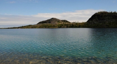
Great Bear Lake is located in the Northwest Territories. With a surface area of 31,328 km2, Great Bear Lake is the largest lake located entirely inside Canadian borders. It is also the fourth largest in North America and the eighth largest in the world. Water flows out of the lake into the Great Bear River, then into the Mackenzie River. Other rivers connected to the lake include the Dease, Camsell and Johnny Hoe. Great Bear Lake is made up of five separate arms, each with their own names: Dease, McTavish, McVicar, Keith and Smith.
The Dease Arm lies north of the Arctic Circle allowing for 24-hour daylight in summer. Great Bear Lake straddles the boundary between the Canadian Shield and the Interior Platform, as well as the northern boreal forest and tundra (see also Geological Regions; Forest Regions). The northeast shores of the lake feature sharp cliffs, numerous islands and fjord-like bays. By contrast, the southwest shores of the lake are flatter, with rich stands of spruce and large swaths of muskeg. The main elevation on this side of the lake is created by the Scented Grass Hills and Grizzly Bear Mountain.
The rivers surrounding Great Bear Lake drain nutrient-poor lands, which, combined with a small watershed, colder temperatures and considerable depth (at its deepest point, Great Bear Lake reaches 452 metres), mean the lake supports relatively few plant and fish species. Of Canada’s large lakes, Great Bear Lake has the fewest number of different fish species (only 16). Because the fish do not migrate much within the lake, its five arms are home to unique populations.
Credit : The Canadian Encyclopedia
Picture Credit : Google


