|
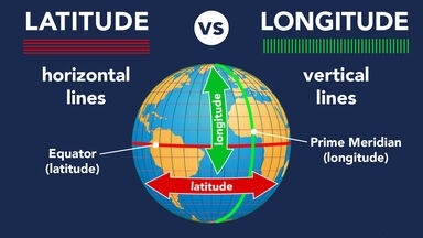
Every place on Earth’s surface can be pinpointed by two figures: its latitude and its longitude. Lines of latitude (called ‘parallels’) form rings around Earth, parallel to the equator. A place’s latitude is given in degrees (°) north or south of the equator, which is considered latitude 0°. On the other hand, lines of longitude (called ‘meridians’) run round Earth from north to south, dividing the world up like the segments of an orange. A place’s longitude is given as degrees west or east of the prime meridian, which is longitude 0°. |
Latitude and longitude are angles that uniquely define points on a sphere. Together, the angles comprise a coordinate scheme that can locate or identify geographic positions on the surfaces of planets such as the earth.
|
Latitude is defined with respect to an equatorial reference plane. This plane passes through the center C of the sphere, and also contains the great circle representing the equator. The latitude of a point P on the surface is defined as the angle that a straight line, passing through both P and C, subtends with respect to the equatorial plane. If P is above the reference plane, the latitude is positive (or northerly); if P is below the reference plane, the latitude is negative (or southerly). Latitude angles can range up to +90 degrees (or 90 degrees north), and down to -90 degrees (or 90 degrees south). Latitudes of +90 and -90 degrees correspond to the north and south geographic poles on the earth, respectively. |
Credit: WhatIs.com
Picture credit: Google


