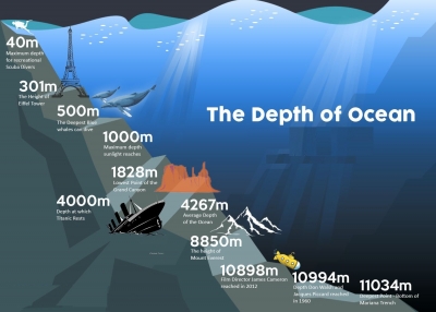
The average depth of the ocean is 3,700 meters (12,100 feet). But the deepest part ever recorded is located in the western part of the Pacific Ocean, in the Mariana Trench, at a depth of around 11,000 meters (36,200 feet).
Bathymetry is the scientific term for measuring the depth of water in oceans, lakes and rivers. Bathymetric maps are similar to land maps in that they show the different underwater landforms in a specific area. Scientists and researchers can use different methods to measure ocean depth.
The different methods are:
1. Sonar
The most common and fastest way of measuring ocean depth uses sound. Ships using technology called sonar, which stands for sound navigation and ranging, can map the topography of the ocean floor. The device sends sound waves to the bottom of the ocean and measures how long it takes for an echo to return. The “echo” is the sound wave reflecting off the seabed and returning to the sonar device.
2. Radar and satellite
Another alternative, though not as fast as sonar, is radar. Similar to sonar, radar requires sending out a type of wave that pings off an object and reflects back. The difference is that radar uses radio waves, a form of electromagnetic wave. But because electromagnetic waves travel slower in water compared with air and become diminished as they travel through water, they are more ideal for atmospheric measurements.
Ocean Depth Measured in the Olden Days
Before the discovery of using sound and radar to measure ocean depth, captains and their crews used a different way to measure the depth of the ocean. Sailors would use a tool called a lead line, which was essentially a lead weight attached to a rope that is marked every 6 feet, a length called a fathom, with a rag or strip of leather. A crew member would then throw the line into the water, and once the lead weight reached the bottom the sailor would measure and record the distance to the ocean floor using the strips on the rope.
The lead line was the most valuable method of measuring depth for navigation and has been used since the fifth century BCE. The tool helped sailors know how deep the water was and if their ship would run aground. The bottom of the lead weight was cupped inward and filled with grease and was used to bring up samples from the ocean floor to help sailors determine if the ocean bed was sand, gravel or mud.
Credit: NIST
Picture Credit : Google


