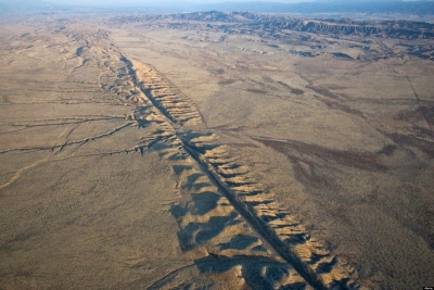
San Andreas Fault, major fracture of the Earth’s crust in extreme western North America. The fault trends northwestward for more than 800 miles (1,300 km) from the northern end of the Gulf of California through western California, U.S., passing seaward into the Pacific Ocean in the vicinity of San Francisco. Tectonic movement along the fault has been associated with occasional large earthquakes originating near the surface along its path, including a disastrous quake in San Francisco in 1906, a less serious event there in 1989, and a strong and destructive quake centred in the Los Angeles suburb of Northridge in 1994 that occurred along one of the San Andreas’s larger secondary faults.
According to the theory of plate tectonics, the San Andreas Fault represents the transform (strike-slip) boundary between two major plates of the Earth’s crust: the Northern Pacific to the south and west and the North American to the north and east. The Northern Pacific plate is sliding laterally past the North American plate in a northerly direction, and hence the San Andreas is classified as a strike-slip fault. The movement of the plates relative to each other has been about 1 cm (0.4 inch) per year over geologic time, though the annual rate of movement has been 4 to 6 cm (1.6 to 2.4 inches) per year since the early 20th century. Parts of the fault line moved as much as 6.4 metres (21 feet) during the 1906 earthquake.
Credit: Britannica
Picture Credit : Google


