In a tearing hurry?

Climate change is making hurricanes wetter, windier and altogether more intense. There is also evidence that it is causing storms to travel more slowly, meaning they can dump more water in one place.

If it were not for the oceans, the planet would be much hotter due to climate change. But in the last 40 years, the ocean has absorbed about 90% of the warming caused by heat-trapping greenhouse gas emissions. Much of this ocean heat is contained near the water’s surface. This additional heat can fuel a storm's intensity and power stronger winds.

Climate change can also boost the amount of rainfall delivered by a storm. Because a warmer atmosphere can also hold more moisture, water vapour builds up until clouds break, sending down heavy rain. During the 2020 Atlantic hurricane season-one of the most active on record - climate change boosted hourly rainfall rates in hurricane-force storms by 8%-11%, according to an April 2022 study in the journal Nature Communications.

The world has already warmed 1.1 degrees Celsius above the pre-industrial average. Scientists at the U.S. National Oceanic and Atmospheric Administration This image obtained from the National Oceanic and Atmospheric Administration (NOAA), shows Hurricane Idalia making landfall in Florida on August 30, 2023. AFP (NOAA) expect that, at 2 degrees Celsius of warming, hurricane wind speeds could increase by up to 10%. NOAA also projects the proportion of hurricanes that reach the most intense levels Category 4 or 5- could rise by about 10% this century. To date, less than a fifth of storms have reached this intensity since 1851.

Picture Credit : Google

Is the color of the oceans changing?

The color of over 56 per cent of the worlits oceans larger than Earths total laut eganse, has changed significantly over the last two decades and human-caused dimate change is likely the driver, according to researchers

These colour changes, subtle to the human eye, cannot be explained by natural, year-to-year variability alone. Ocean colour, a literal reflection of the life and materials in its waters, in regions near the equator was found to have steadily turned greener over time, indicating changes in the ecosystems within the surface oceans.

The green colour of the ocean waters comes from the green pigment chlorophyll present in phytoplankton. the plant-like microbes abundant in upper ocean Scientists are, therefore, keen to monitor phytoplankton to see their response to climate change

The researchers from the Massachusetts Institute of Technology (MIT), US, and other institutes in their paper published in the joumal Nature, say that it would take 30 years of tracking chlorophyll changes before climate-change-driven trends would show, because natural, annual variations in chlorophyll would overwhelm those influenced by human activities.

In a 2019 paper, study co-author Stephanie Dutkiewicz and her colleagues showed that monitoring other ocean colours whose annual variations are much smaller than those of chlorophyll, would convey mom dear signals of climate-change-driven changes and that they might even be apparent in 20 years, rather than 30.

"It's worth looking at the whole spectrum, rather than just trying to estimate one number from bits of the spectrum." said lead author B. B. Cael of the National Oceanography Center. Cael and team then statistically analysed all the seven ocean colours recorded by satellite observations from 2002 to 2022 together.

To understand climate changes contribution to all these changes, he used Dutkiewicz's 2019 model to simulate the Earth's oceans under two scenarios-one with greenhouse gases and the other without them. The greenhouse gas model predicted changes to the colour of about 50 per cent of the world's surface oceans in under 20 years close to Cael's conclusions from his real-world satellite data analysis. "This trend is consistent with anthropogenic climate change"

Picture Credit: google

How ocean temperature affect climate?

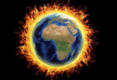
As the world's oceans continue to take in more and more heat, it affects more than just the water. How? Come, let's find out

A new record

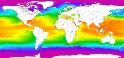
The world's oceans, which have absorbed most of the excess heat caused by humanity's carbon pollution, continued to see record-breaking temperatures last year, according to research published recently. The research, published in the journal Advances in Atmospheric Sciences, was based on observations from 24 scientists across 16 institutes worldwide. The study, by researchers in China, the U.S., Italy, and New Zealand, said that 2022 was "the hottest year ever recorded in the world's oceans". Heat content in the oceans exceeded the previous years levels by around 10 Zetta joules-equivalent to 100 times the electricity generation worldwide in 2021. according to the authors. Records going back to the late 1950s show a relentless rise in ocean temperatures with almost continuous increases going back to around 1985.

Why are oceans important?

About half of the world's total amount of oxygen is produced in oceans, through the plants there. Equally importantly, oceans play a crucial role in the climate of the world. They carry the Sun's heat from the Equator to the Poles, thereby regulating our climate and weather patterns. Apart from these, oceans are indispensable for the world economy, through several aspects such as trade, transport, food, medicine, recreational activities, tourism, etc. In fact, the livelihood of millions of people across the globe are dependent on oceans and seas. In addition to all these, oceans are thriving ecosystems, nurturing all kinds of life forms-from the smallest to the largest- within them.

What causes the warming of oceans?

More than two-thirds of our planet's surface is covered by water, and oceans make up a large portion of that. Due to their sheer size, they can absorb heat from the Sun without their temperatures increasing much. Apart from sunlight, oceans receive heat from other sources such as greenhouse gases. But when there's a lot of heat to be absorbed, oceans become warmer with substantial difference in temperature increase. A study has found that over the last few decades, nearly 90% of excess heat from greenhouse gas emissions has been absorbed by the ocean while the rest are absorbed by land, the atmosphere, etc. While land surfaces are protected due to this, it warms oceans to devastating results.

What happens when oceans warm?

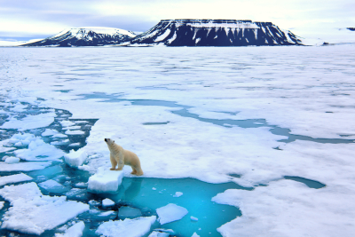
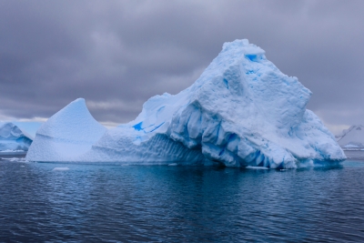
Due to thermal expansion, the volume of water increases when it is warm. In addition, warm ocean water melts sea ice and delays ice formation during winter. This is a major reason for global sea-level increase. Extremely high temperatures in the ocean are called marine heatwaves, and they can harm marine creatures. Further, they can affect migration of marine animals, cause coral bleaching, ocean acidification (increase in the waters acidic content due to excessive intake of carbon dioxide from the atmosphere), and deoxygenation (warm water can hold only low amounts of dissolved oxygen). Aspects such as acidification and deoxygenation affect not just marine creatures but also their habitats and ecosystems.

The ocean-land connection

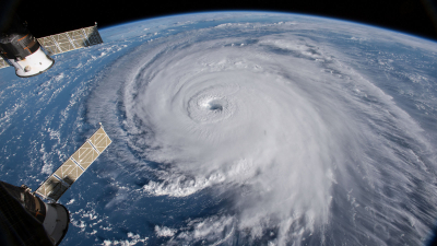
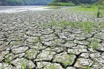
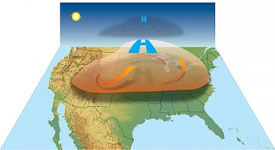
Whatever affects the oceans and seas affects the land too - either directly or indirectly. Warming ocean waters impact how heat is distributed globally. This results in erratic climate and weather patterns, leading to extreme weather events such as drought heat waves, cold waves, wildfires, floods, severe cyclones, etc. As sea levels increase, they can submerge coastal areas, displacing those inhabiting these regions. Further, those dependent on the oceans for their livelihood-for example, fisherfolk- may lose their livelihood if oceans cannot help marine creatures survive. If more and more people choose to leave behind coastal areas threatened thus, it could lead to crowding of non-coastal areas, leaving a society that's constantly in conflict over food space, opportunities, and life itself.

Picture Credit : Google 

Why is ice melting rapidly in Greenland?

Climate change experts have been speaking about the dangers posed by melting ice for some time now. A new study has now helped uncover a previously unseen way in which the ice and ocean interact. And the bad news? Based on their findings, the glaciologists suggest that even the climate change community has been vastly underestimating the extent of future sea-level rise that polar ice deterioration would cause.

Researchers at the University of California, Irvine and NASA's Jet Propulsion Laboratory conducted a study of Petermann Glacier in north-west Greenland to come up with these findings.

Their results form the subject of a paper published in Proceedings of the National Academy of Sciences in May.

What is a grounding line?

A glacier's grounding line corresponds to the place where ice detaches from the land bed and begins floating in the ocean. Based on satellite radar data from three European missions, the team of researchers learned that Petermann Glacier's grounding line shifts considerably during tidal cycles. This, in effect, allows warm seawater to intrude and melt ice at an accelerated rate.

For ocean-reaching glaciers, the traditional view of grounding lines was that they did not migrate during tidal cycles and did not experience ice melt. This new study replaces that thinking with the newly gained knowledge. Warm ocean water intrudes beneath the ice and the melting rate is highest at the grounding zone.

Between 2016 and 2022, the Petermann Glaciers grounding line has retreated nearly 4 km. A 670-foot-tall cavity in the underside of the glacier was carved out by warm water.

More sensitive to warming The researchers' paper stresses that the Greenland ice sheet has lost billions of tonnes of ice to the ocean in the last few decades. Most of the loss of ice is caused by warming of subsurface ocean waters, which is a result of our planet's changing climate.

According to the researchers, the ice-ocean interactions make the glaciers more sensitive to ocean warming and these dynamics have so far not been included in predictive models. If we were to include them, projections of sea level rise would increase by up to 200% for all glaciers ending in the ocean, which includes most of northern Greenland and all of Antarctica.

Picture Credit : Google 

What is El Nino climate pattern?

This affects ocean temperatures, speed and strength of ocean currents, the health of coastal fisheries, and also the local weather in several countries

The World Meteorological Organisation (WMO) has predicted a high probability of El Nino developing later this year. This will fuel higher global temperatures. Let us know more about this phenomenon.

El Nino

El Nino, Spanish word for 'little boy', is a natural climate pattern associated with the warming of the central Pacific Ocean waters near South America. It is the warm phase of El Nino-Southern Oscillation (ENSO), a recurring phenomenon involving changes in the Pacific Ocean temperature.

El Nino affects the ocean temperatures, speed and strength of ocean currents, the health of coastal fisheries, and also the local weather in several countries. For instance, El Nino can cause rain in South America while threatening drought in Indonesia and Australia.

It occurs irregularly at two- to seven-year intervals and episodes usually last nine to 12 months. An El Nino year creates a mini global-warming crisis because the warm water spreading across the tropical Pacific releases a large amount of heat into the atmosphere. It results in hot and dry weather in Southeast Asia.

El Nino events are indicated when the temperature of the sea surface increases by more than 0.5° C for at least five successive overlapping three-month seasons.

El Nino events of 1982-83 and 1997-98 were the most adverse of the 20th Century. During 1982-1983, the sea surface temperatures in the eastern tropical Pacific were 7.8-12.8° C above normal. These strong temperature increases caused harsh drought in Australia, typhoons in Tahiti, and record rainfall and flood in central Chile.

The 1997-1998 El Nino event was the first time that was scientifically monitored from beginning to end. It caused drought conditions in Indonesia, Malaysia, and the Philippines. Peru faced very heavy rains and severe flooding. While California faced winter rainfall, the Midwest received record-breaking warm temperatures. Strong El Nino events can cause weaker monsoons in India and Southeast Asia and increased rainfall during the rainy season in sub-Saharan Africa.

ENSO and La Nina

ENSO involves changes in the temperature of the central and eastern tropical Pacific Ocean. This affects the rainfall distribution in the tropics and weather across the world. El Nino and La Nina are the extreme phases of the ENSO cycle. Besides, there is another phase neither El Nino or La Nina. It is known as the ENSO-neutral.

La Nina, Spanish word for 'little girl', is the cool phase of ENSO. During La Nina events, trade winds (blowing east to west just north and south of the Equator) are stronger than usual and push more warm water toward Asia. Meanwhile, near the west coast of the Americas, upwelling increases, bringing cold and nutrient-rich water to the surface. During such a year, the winter temperatures are warmer than normal in the South and cooler than normal in the North. La Nina ended this year after a three-year run and the tropical Pacific is at present in an ENSO-neutral state.

Prediction

The WMO has predicted a 60% chance for a transition from ENSO-neutral to El Nino during May-July 2023, an increase to about 70% in June-August and 80% in July-September.

This April, the India Meteorological Department (IMD) predicted that an El Nino will likely develop during this southwest monsoon. However, the IMD has stated that India will likely receive a normal amount of monsoon rain this year despite the probability of the weather phenomenon.

Picture Credit : Google 

What are the solutions for a warming world?

With a warming planet searing us, we are desperate to find cool solutions. In a seeming paradox what contributed to the climate change crisis such as coal plastic and oil rigs also hold the key to eco-friendly solutions. But how? Let's find out...

Coal is a fossil fuel that is largely blamed for the current climate change crisis. Now, in a seeming paradox, energy experts are turning to long-abandoned coal mines as a source of carbon-free power! These mines are estimated to contain millions of gigawatt hours or GWh of heat, with the potential to store more. Today, there are many ongoing projects across the UK and in Europe to tap this energy source, especially in places where plants that treat toxic mine water from closed mines already exist.

Once a mine is shut down, the shafts fill with water. The water may be surface water (from rainfall or flooding), or groundwater that seeps up from below. The water is naturally warm as it is deep underground, with temperatures ranging from 15 degrees C to 20 degrees C. It is hot enough to heat homes in winter and cool enough to keep them mild in summer. Mine water energy is also 10 per cent cheaper.

It is not a new idea. In 1989, a packaging firm in the town of Springhill, in the Canadian province of Nova Scotia, dug the world's first borewell to draw up water from dormant coal mines near it to heat its office building.

Futuristic fabric

An American apparel startup called LifeLabs Design set up by a research team from Stanford University, has created clothing from polyethylene (PE) that keeps the wearer's skin cool in the heat and warm in the cold. The first is called Cool life and the second, you guessed it, WarmLife!

Polyethylene is the type of plastic found in cling wrap and the thin, transparent bags used by grocery stores to pack items. The inventors discovered that the plastic allowed infrared radiation to pass right through it. Most fabrics trap infrared radiation or heat generated by the skin. CoolLife fabric lowers the wearer’s skin temperature by at least 1 degree Celsius when compared to cotton.

The company's WarmLife fabric works on the principle of reflectivity. The side that touches the skin has a 'nano coat’ or a microscopic aluminium layer that reflects the body's infrared radiation and traps that heat inside an inch-thick layer of insulation. The fabric is 30 per cent warmer than clothing of similar weight and bulk.

The company's WarmLife fabric works on the principle of reflectivity. The side that touches the skin has a 'nano coat or a microscopic aluminium layer that reflects the body's infrared radiation and traps that heat inside an inch-thick layer of insulation. The fabric is 30 per cent warmer than clothing of similar weight and bulk.

Polyethylene is the most sustainable among synthetic and natural textiles. The fabrics made from PE are ecologically friendlier than other synthetic and even natural fabrics. Polyester, wool and cotton use large amounts of fuel and water in their entire production process. WarmLife jackets and vests use much less fuel and water in their manufacture. The fabric is 97 per cent recycled material from single-use plastics.

Rigs to reefs

There are more than 12,000 offshore oil and gas platforms worldwide. There comes a time when the rigs produce too little oil and gas for extraction to be profitable. The well is sealed off, but it is too expensive to dismantle the massive structure entirely. The platform which is above the surface is easier to cart away, but the huge steel pylons below it are not. One would expect these rusting hulks to damage marine ecosystems, but surprisingly, they have had the opposite effect!

Offshore oil and gas rigs that have been decommissioned have become safe havens for a variety of marine life! The subsurface rig (the part below the water) provides the ideal skeleton for coral reefs to build on! Decommissioned oil rigs in America are the most productive man-made marine habitats in the world. They provide marine wildlife with food, shelter from predators and a safe breeding ground.

Since 1984, the U.S. government has encouraged states to turn defunct rigs into reefs. Oil companies on the east coast in Alabama, Florida, Louisiana, Mississippi and Texas, have converted more than 500 rigs into artificial reefs. In fact, the rigs in the Gulf of Mexico have become hotspots for diving, snorkelling and recreational fishing.

Picture Credit : Google 

How much impact does aviation have on climate change is it the most polluting form of travel?

The impact of flying on climate change has been well established. On average, the aviation industry generates about 1 billion tons of CO2 worldwide every year. This number is comparable to that of Japan, which is the world's third largest economy.

Add to this the fact that global emissions from flights have been increasing at the rate of 2.5% every year. In fact, over the next 30 years, the aviation industry will likely produce more CO2 than that of its whole history!

Radical solutions required

Even though fossil fuels are increasingly being replaced by renewable energy sources in power generation and electric vehicles continue to grow into a bigger market, there hasn't been enough done to address pollution from aircraft. In such a climate, the need is for bold, radical solutions. Researchers from the University of California San Diego School of Global Policy and Strategy have called for the same through a new commentary article that appeared in Nature in September.

The authors suggest that the two most commonly proposed solutions-carbon offsetting and cleaner fuels - are rather inadequate. While offsetting falls flat owing to poor accountability, cleaner fuels can't yet be produced sustainably in large volume and low costs to replace all jet fuel. Additionally, these two solutions do not address the dimate impact of contrails-clouds produced by aircraft engine edhaust - that can trap heat radiating from the Earth's surface.

Three steps

To address a warming planet, the authors suggest three steps for the industry as a whole. Firstly, they recommend the industry and various governments to work together to be more aware of the risks involved and the role that aviation plays in the dimate crisis.

Next up, they wish for collaborations between the most motivated governments and firms to take risks on new technologies, which could then inspire others to follow their lead. The authors only provide examples such as a partnership between the Norwegian government and businesses to create electric airplanes, but also lay out strategies of how collaborations could be used to ignite other advances.

Finally, they stress the importance of research, not just to better understand contrails and chemical interactions in the atmosphere, but also to provide solutions. They envision these solutions to not just be technological, but also economic and political, thereby providing for a greener future.

Picture Credit : Google 

Heatwaves to make regions uninhabitable within decades

Heatwaves will become so extreme in certain regions of the world within decades that human life there will be unsustainable, say UN, Red Cross.

GENEVA A HOW United Nations Red Cross report into climate change alludes to certain parts of the world becoming so hot within a matter of decades that human beings will be unable to survive there.

The bleak joint report predicts extreme heatwaves could become so fierce that they exceed human physiological and social limits in parts of Latin America, central Africa and south and southwest Asia.

 The world's lowest-income countries- those least responsible for climate change-are already experiencing a disproportionate increase in extreme heat, as was witnessed this year with the heatwave catastrophes in Somalia and Pakistan

The report is published by the UN's Office for the Coordination of Humanitarian Affairs (OCHA) and the International Federation of Red Cross and Red Crescent Societies (IFRC) ahead of Novembers COP27 climate change summit in Egypt.

What can be done?

IFRC secretary-general Jagan Chapagain urged countries at COP27 to: invest in climate adaptation and mitigation in the regions most at risk.

OCHA and the IFRC suggested five main steps to help combat the impact of extreme heatwaves, including: providing early information to help people and authorities react in time and finding new ways of financing local-level action.

They also included humanitarian organisations testing more "thermally-appropriate emergency shelter and "cooling centres, while getting communities to alter their development planning to account of likely extreme heat impacts.

OCHA and the IFRC said there were limits to extreme heat adaptation measures. Some, such as increasing energy-intensive air conditioning, are costly, environmentally unsustainable and contribute themselves to climate change. The report concludes that if greenhouse gas emissions, which cause climate change, are not aggressively reduced now, the world will face previously unimaginable levels of extreme heat.

Picture Credit : Google 

What killed off billions of Alaska's snow crabs?

Alaska's snow crabs are named so for their love of cold water, which they inhabit. But, due to the heatwaves in 2018 and 2019, their habitats were not cold enough, and this is suspected to be the "key culprit in the mass die-off. The warmer are believed to have affected the species in more ways than one.

Recently, the Alaska Department of Fish and Game announced that the Bering Sea snow crab season will stay closed for catching during 2022-23 to conserve and rebuild the species. (Though they are found in a couple of other places too, it is in Bering Sea that these crabs are abundant and also grow to reach "fishable sizes".) The announcement follows an annual survey by the National Oceanic and Atmospheric Administration, which discovered that the crustacean numbers "fell to about 1.9 billion in 2022, down from 11.7 billion in 2018", a reduction of nearly 85%. What caused this dramatic loss, and how will closing the season help the species? Come, let's find out.

Alaska's snow crabs are named so for their love of cold water, which they inhabit. But, due to the heatwaves in 2018 and 2019, their habitats were not cold enough, and this is suspected to be the "key culprit' in the mass die-off. The warmer temperatures are believed to have affected the species in more ways than one. For instance, studies "have pointed toward a higher prevalence of Bitter Crab Disease as the temperature heats up". Further, unlike in cold waters, these crabs "need more energy to stay alive" in warmer waters, causing them "metabolic stress", which likely led to limited movement, and eventual starvation. Apart from this, young crabs require low temperatures of water where their mobility is high, helping them evade predation. When the waters warm, they slow down, and their chances of being targeted by their major predator- the Pacific cod - are higher. 5

However, it is interesting to note that a marine biologist has said that the current predicament was linked more to climate change rather than to overfishing because fishing "removes only large adult males" but the decline in population appears across all sizes of snow crabs. If that's the case, what explains closing the area for catching these crabs?

Because, the temperature of the water has now returned to normal; closing will help the reproduce and recover. Comfortingly, "this years survey saw significant increases in the immature crabs compared to last year".

Picture Credit : Google 

What is a heat dome?

Europe recently experienced an intense heatwave resulting in record temperatures owing to the creation of a heat dome. But what is a heat dome? Come, let's find out.

A high-pressure system hovering in the atmosphere over Europe trapped the heat in a phenomenon called "heat dome". This weather phenomenon begins when there is a strong change in ocean temperatures.

Imagine a overhead water tank in summer. As the heat rises, the water in the tank turns warm but the moisture and steam cannot escape due to the tank lid. Similarly, a heat dome occurs when the atmosphere traps a mass of hot ocean air like a lid or cap over an area in dry summer conditions.

When this hot air attempts to escape, the high pressure in the atmosphere pushes it down. Under the dome, the air unable to escape sinks and compresses, releasing even more heat. Besides, it also blocks other weather systems from moving in. This leads to an increase in temperatures at ground level. So people, crops, and other living beings under it suffer terribly.

According to scientists, heat domes are linked to the behaviour of the jet stream, a band of strong winds high in the atmosphere that generally runs from west to east. "Normally, the jet stream has a wavelike pattern, meandering north and then south and then north again. When these meanders in the jet stream become bigger, they move slower and can become stationary. That's when heat domes can occur."

This dome of hot air can stretch over vast regions and last for days together, leading to extreme temperatures and the formation of a relentless heatwave. The hotter the temperature the stronger the heat dome gets.

This stagnant weather pattern usually leads to weak winds and a rise in humidity. Heat domes can badly affect us, raising the risk of heat illnesses and deaths as people would not be able to cool down properly.

Picture Credit : Google 

HOW DO SANDSTORMS IMPACT LANDSCAPES?

Not only can sandstorms damage and bury plants and seedlings, when sand is carried in the wind, the suspended particles trap the Sun’s heat before it can reach the ground. As a result, the air in the area where this sand is deposited or remains suspended becomes warmer and drier. It cannot retain moisture any more. The increase in temperature and decreased precipitation reduce plant growth and result in greater soil erosion, which leads to changes in the landscape.

Sand and dust storms cause significant negative impacts on society, economy and environment at local, regional and global scale.  There are three key factors responsible for the generation of sand and dust storms – strong wind, lack of vegetation and absence of rainfall. The environmental and health hazards of such storms cannot be reduced permanently; however its impact can be reduced by taking appropriate measures.

As the dust cloud rises, it reduces the horizontal visibility which can impact human life in many ways. The fine suspended particles also contain contaminants, bacteria, pollens, which cause negative health impacts such as allergies and respiratory diseases.

Dust also carries airborne pollutants such as toxins, heavy metals, salt, sulphur, and pesticides etc. which cause significant health impacts when people inhale the contaminated dust.  Dust can corrode buildings and other built infrastructure as it contains high level of salts, especially in the GCC countries.

Picture credit: Google

WHAT ARE ICEBERGS AND WHY ARE THEY DANGEROUS?

Icebergs are huge pieces of ice that break off glaciers and float into the ocean. They can be more than five metres in height but most of their bulk remains submerged. Icebergs are dangerous. If a ship hits an iceberg, it can be badly damaged and sink. The dangerous waters are in the North Atlantic, around Greenland, and in the Southern Hemisphere around Antarctica. Since I912, after the luxury liner Titanic hit an iceberg and sank, the International Ice Patrol tracks icebergs and warns ships in the North Atlantic. However, satellite data used to monitor icebergs can only spot icebergs larger than 500 m2.

Icebergs are large chunks of ice that break off from glaciers. This process is called calving. Icebergs float in the ocean, but are made of frozen freshwater, not saltwater.

Most icebergs in the Northern Hemisphere break off from glaciers in Greenland. Sometimes they drift south with currents into the North Atlantic Ocean. Icebergs also calve from glaciers in Alaska.

In the Southern Hemisphere, almost all icebergs calve from the continent of Antarctica.

Some icebergs are small. Bergy bits are floating sea ice that stretch no more than 5 meters (16.5 feet) above the ocean. Growlers are even smaller.

Icebergs can also be huge. Some icebergs near Antarctica can be as big as Sicily, the largest island in the Mediterranean Sea. As little as one-eighth of an iceberg is visible above the water. Most of the mass of an iceberg lies below the surface of the water. This is where the phrase "tip of the iceberg" came from, meaning only part of an idea or problem is known.

There are many different kinds of icebergs. Brash ice, for instance, is a collection of floating ice and icebergs no more than 2 meters (6.5 feet) across. A tabular berg is a flat-topped iceberg that usually forms as ice breaks directly off an ice sheet or ice shelf.

The ice below the water is dangerous to ships. The sharp, hidden ice can easily tear a hole in the bottom of a ship. A particularly treacherous part of the North Atlantic has come to be known as Iceberg Alley because of the high number of icebergs that find their way there. Iceberg Alley is located 250 miles east and southeast of Newfoundland, Canada.

Picture credit: Google 

DOES ANYONE LIVE AT THE NORTH POLE?

Drifting ice makes it very difficult to create settlements at the North Pole. It is an uninhabited area that does not belong to any nation. But it does have research stations based there to study the region and look for changes in the ecosystem.

No one really resides at the true North Pole, not even the Inuit people who dwell in the nearby Arctic regions of Greenland, Russia, Canada, etc. It’s almost impossible to build a permanent home here, as the ice is in constant motion and shrinks significantly in summers. Thus, it is not viable to build permanent structures or establish any sort of community there. Another challenge of establishing a community at the true North Pole is that there is no availability of potable water. Even the adventurous explorers who come to the North Pole just for a short trip must ensure that there is a sufficient supply of water available to them. Early Arctic explorers had a very hard time keeping themselves hydrated here. The water of the nearby Arctic is too salty to meet day-to-day consumption requirements. In extreme cases, people survived by eating snow. Eating snow isn’t a good thing either and increases the risk of hypothermia, a condition in which the body loses heat rapidly, plunging to alarming or fatal levels.

Picture credit: Google

WHAT IS IT LIKE AROUND THE NORTH POLE?

In geographical terms, the North Pole is the northernmost point on Earth’s axis of rotation. It is located in the Arctic, on the drifting, two to three metres thick ice that covers the waters of the ocean here. The warmest the North Pole gets is 0°C. Usually, though, the temperature is a bitterly cold sub-zero. In summer, the North Pole is bathed in the constant daylight, but the winter is a long, continuous dark night.

The North Pole is the northernmost point on Earth. It is the precise point of the intersection of the Earth's axis and the Earth's surface.

From the North Pole, all directions are south. Its latitude is 90 degrees north, and all lines of longitude meet there (as well as at the South Pole, on the opposite end of the Earth). Polaris, the current North Star, sits almost motionless in the sky above the pole, making it an excellent fixed point to use in celestial navigation in the Northern Hemisphere.

The North Pole sits in the middle of the Arctic Ocean, on water that is almost always covered with ice. The ice is about 2-3 meters (6-10 feet) thick. The depth of the ocean at the North Pole is more than 4,000 meters (13,123 feet).

The Canadian territory of Nunavut lies closest to the North Pole. Greenland, the world's largest island and an independent country within the Kingdom of Denmark, is also close to the pole.

The North Pole is much warmer than the South Pole. This is because sits at a lower elevation (sea level) and is located in the middle of an ocean, which is warmer than the ice-covered continent of Antarctica. But it's not exactly beach weather. In the summer, the warmest time of year, the temperature is right at the freezing point: 0 degrees Celsius (32 degrees Fahrenheit.)

Because the Earth rotates on a tilted axis as it revolves around the sun, sunlight is experienced in extremes at the poles. In fact, the North Pole experiences only one sunrise (at the March equinox) and one sunset (at the September equinox) every year. From the North Pole, the sun is always above the horizon in the summer and below the horizon in the winter. This means the region experiences up to 24 hours of sunlight in the summer and 24 hours of darkness in the winter.

Credit: National Geographic

Picture credit: Google

IN A YEAR HOW MANY CLOUD-FREE NIGHTS DOES THE ATACAMA DESERT GET?

At 16,570 feet (5,050 meters) in elevation, the Atacama Desert plateau may be the best place in the world to spot the solar system's secrets. To the delight of amateur astronomers, the desert sees as many as 330 cloud-free nights each year. High along the Atacama Desert plateau, an array of observatories track the celestial bodies in our solar system and beyond.

The Atacama Large Millimeter Array/submillimeter (ALMA) — a network of 66 telescopes run by an international collaboration of scientific organizations from Europe, North America, East Asia and the Republic of Chile — spies on faraway stars and the planets birthed around them.

The European Space Observatory's Very Large Telescope, helped spot the TRAPPIST-1 system of Earth-like planets, located a mere 40 light-years from Earth, and has gathered data on distant exoplanet atmospheres. This telescope, along with others, has uncovered some of the universe's most intriguing oddities and provided a wealth of data to researchers and astronomers worldwide.

Credit: LIVE SCIENCE

Picture Credit: Google