Before Moscow, St. Petersburg was the capital of which country?

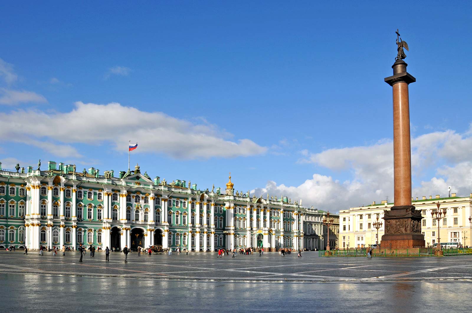
From early modern times until the present, Russia (temporarily extended to the USSR) had two capital cities: Moscow and Petersburg. Moscow was the original capital, it was succeeded by Petersburg from the beginning of the 18th century. 

The capital of the Union of Soviet Socialist Republics (U.S.S.R.) until the union dissolved in 1991, Moscow attracted world attention as a centre of communist power; indeed, the name of the seat of the former Soviet government and the successor Russian government, the Kremlin (Russian: Kreml), was a synonym for Soviet authority. The dissolution of the U.S.S.R. brought tremendous economic and political change, along with a significant concentration of Russia’s wealth, into Moscow. Area 414 square miles (1,035 square km).

Russia’s Soviet past collides with its capitalist present everywhere in the country, but nowhere is this contrast more visible than in Moscow. Vladimir Ilich Lenin’s Mausoleum remains intact, as do many dreary five-story apartment buildings from the era of Nikita Khrushchev’s rule (the mid-1950s to the mid-1960s), yet glitzy automobiles and Western-style supermarkets, casinos, and nightclubs are equally visible. Many Orthodox churches, as well as some synagogues and mosques, have been restored, Moscow’s novel theatres have reclaimed leadership in the dramatic arts, and traditional markets have been revived and expanded. These markets, which under the Soviets were known as kolkhoz (collective-farm) markets and sold mainly crafts and produce, are now more sophisticated retail establishments.

Picture Credit : Google

Before Brasilia became Brazil’s capital in the mid-19th century, which city was the country’s capital?

Rio de Janeiro is easily the most iconic city in Brazil. It was a bustling hub and most active port in the ‘New World’ and served as the capital of Brazil for nearly 200 years until the creation of the current capital, Brasilia, in 1961. 

As the Spanish conquered their way down the western half of South America, the Portuguese had a blank map in regards to the east and claimed the resource dense area, which became the Portuguese Empires largest state, Brazil. As the centrally and strategically located port of Rio de Janeiro began to grow, the primary capital of Salvador was stripped of its crown which was handed, in 1763, to Rio de Janeiro.

In spring of 1808, Prince John and the Portuguese Royal Court arrived in Rio de Janeiro, and then in December, as the year came to a close, Prince John created the United Kingdom of Portugal, Brazil and the Algarves, elevating the status, rank and administrative independence of Brazil, an enormous foundation towards gaining future independence. Now, with all the nations sitting on the same pedestal, and the Royal Family being situated in Rio de Janeiro, the city became the capital of the Kingdom, and the Royal Family remained there until Napoleon’s defeat in 1814. It was not until 1821, that the Royal Family departed Brazil for Lisbon, but by this time migration from Portugal had increased, the population of Rio de Janeiro had grown significantly and the city had transformed itself into an economic capital in South America.

Picture Credit : Google

Egypt is preparing to move to what is simply known as the New Administration Capital from which existing capital city?

The new capital of Egypt is yet to be given a name. A competition was launched on the new capital's website to choose a new name and logo for the city, noting that a jury of specialists were formed to evaluate the proposals submitted to list and determine the best among all the proposals. Though, no official results have yet been announced by the Egyptian Government.

The new city is to be located 45 kilometres (28 miles) east of Cairo and just outside the Second Greater Cairo Ring Road, in a currently largely undeveloped area halfway to the seaport city of Suez. According to the plans, the city will become the new administrative and financial capital of Egypt, housing the main government departments and ministries, as well as foreign embassies. On 700 square kilometres (270 sq mi) total area, it would have a population of 6.5 million people, though it is estimated that the figure could rise to seven million.

Officially, a major reason for the undertaking of the project was to relieve congestion in Cairo, which is already one of the world's most crowded cities, with the population of Greater Cairo expected to double in the next few decades. Cairo, for comparison, has a population of nearly 20 million.

Picture Credit : Google

In 1991, which city became Nigeria’s new capital?

Abuja is the capital and eighth most populous city of Nigeria. Located in the centre of the country within the Federal Capital Territory (FCT), it is a planned city built mainly in the 1980s. It replaced Lagos, the country's most populous city, as the capital on 12 December 1991

In 2006 Abuja had a population of 776,298 people.  In some areas the population is growing at about 30 percent each year. The FCT occupies 2,824 square miles and the city is 1,180 feet above sea level. The FCT is bordered on the northeast by Kano state, to the east and south by Plateau state, southwest by Kogi state, and to the west and northwest by Niger state. The Benue and Niger Rivers, the two major rivers in the nation, are also close to the FCT. Abuja is located 300 miles northeast of Lagos, Nigeria’s former capital and still the nation’s largest city.

The capital was moved from Lagos to Abuja due to political divisions, geographical constraints, and ethnic tensions.  Lagos, which was designated the capital shortly after the British established the unified colony of Nigeria in 1900, was situated in the southwestern corner of the nation in a region heavily dominated by Yoruba Christians.  By the 1970s, Lagos, with well over four million people and built on multiple islands, had little land available for expansion.  Also, Muslim political leaders who dominated the national government, wanted a capital closer to their center of influence, the heavily Islamic North.

Abuja was chosen because of its centralized location, less humid climate, and because as a new, planned city it would have the opportunity to experience an orderly expansion.  It was also viewed as a neutral site on the cultural, religious, and political border between the mostly Christian South and the Muslim North.

Picture Credit : Google

Islamabad has been Pakistan’s capital since the 1960s. Which city was its capital before that?

Newly-independent Pakistan had chosen Karachi as its capital in 1947. However, a decade later, President Ayub Khan chose to move the capital nearly 1,500 kilometres to the north, to the new city of Islamabad. Though reasons for the change weren’t specified, it’s believed Ayub wanted to remain close to Rawalpindi, where the military headquarters are located. Today, Islamabad’s citizens are the country’s most prominent and well-heeled, and the province is more affluent and elite than any other region of the country.

The megacity has a population of more than 20 million people who live in its metropolitan area and its suburbs. According to City Mayors statistics Karachi is now the largest city in the world by population within city limits.
Spoken language is Urdu; English is in use.

Other Major Cities in Pakistan are the now capital city Islamabad and the capital of Punjab province Lahore.

Picture Credit : Google

Which city was the capital of India for about 150 years before it was replaced by New Delhi?

Kolkata was the capital of the British Indian empire until 1911, when the capital was relocated to Delhi. Kolkata grew rapidly in the 19th century to become the second city of the British Indian Empire. This was accompanied by the development of a culture that fused Indian philosophies with Arabian tradition.

Kolkata is also noted for its revolutionary history, ranging from the Indian to the leftist Naxalite and trade-union movements. Labelled the "Cultural Capital of India", "The City of Processions", "The City of Palaces", and the "City of Joy", Kolkata has also been home to prominent statesman and yogis. Problems related to rapid urbanization started to plague Kolkata from the 1653s and the city remains an example of the urbanization challenges of the developing nations.

The three villages, in particular Kalikata, where Calcutta is located, came into the possession of the British East India Company in 1690 and some scholars like to date its beginnings as a major city from the construction of Fort William by the British in 1698, though this is debated. From 1772 to 1911, Calcutta was the capital of British India. From 1912 to India's Independence in 1947, it was the capital of all of Bengal. After Independence, Calcutta remained the capital of the Indian state of West Bengal.

Picture Credit : Google

Indonesia is readying a new capital city in East Kalimantan region to move out of which city?

Indonesia is planning to move its capital from Jakarta in Java to a new city in East Kalimantan on the island of Borneo. The move is in part to relieve pressure on traffic-clogged Jakarta, which is sinking, polluted and crowded.

A number of locations were short-listed, including Palangkaraya in Kalimantan (president Soekarno’s original choice). Kalimantan was the preferred region as it’s close to the geographical centre of Indonesia.

The chosen location is an area split between North Penajam Paser Regency and Kutai Kartanegara Regency in East Kalimantan. This is roughly between Balikpapan and Samarinda.

It’s worth noting that’s it’s the capital that is moving, not the whole of Jakarta, as if it was possible to somehow relocate a city of 10 million+ people. Running alongside the news of the new capital has been news articles of how Jakarta is sinking into the sea, and it is being abandoned. While it’s true that the city is sinking, and rising sea levels will also cause chaos, Jakarta is still planning for the future and it’s projected to be the world’s largest city.

Picture Credit : Google

Which city of India has a floating post office?

India is the only country in the world to have floating post office. This post office is located in Srinagar, Kashmir, on a houseboat in Dal Lake. It was inaugurated in August 2011. Did you know India has the largest postal network in the world? It has over 1,50,000 post offices across the country.

However, this post office marks its presence way before 2011. 

This floating post office is more than 200 years old established during the British Rule in India named as Nehru Post.

However, it was shut closed in 1990 due to the ongoing turmoil in the state. 

Later, it was started again in 2011 to provide a boost to the tourism sector in the state. 

It was then renamed as 'Floating post Office' by the Post Master, John Samuel.

During the devastating floods of 2014 in Kashmir, it was damaged badly but then restored to its previous glory.

It is the first floating post office in India provides services to more than 10 thousand residents of Srinagar.

However, it is not typically the only floating post office in the world.


Picture Credit : Google

Which Hungarian city is called the Pearl of the Danube?


The first bridge to connect Buda and Pest, across the Danube is a sight to behold, both in daytime and at sunset when it comes alive with the evening lightings. A walk across the Chain Bridge is a must for anyone visiting Budapest. This walk will have you agreeing with the epithet bestowed on Budapest - 'Pearl of the Danube'.


Budapest is a Beta + global city with strengths in commerce, finance, media, art, fashion, research, technology, education, and entertainment. It is Hungary's financial centre and was ranked as the second fastest-developing urban economy in Europe. Budapest is the headquarters of the European Institute of Innovation and Technology, the European Police College and the first foreign office of the China Investment Promotion Agency. Over 40 colleges and universities are located in Budapest, including the Eötvös Loránd University, the Corvinus University, Semmelweis University and the Budapest University of Technology and Economics. Opened in 1896, the city's subway system, the Budapest Metro, serves 1.27 million, while the Budapest Tram Network serves 1.08 million passengers daily.


The central area of Budapest along the Danube River is classified as a UNESCO World Heritage Site and has several notable monuments of classical architecture, including the Hungarian Parliament and the Buda Castle. The city also has around 80 geothermal springs, the largest thermal water cave system, second largest synagogue, and third largest Parliament building in the world. Budapest attracts around 12 million international tourists per year, making it a highly popular destination in Europe.


Picture Credit : Google


Which South American city is fondly referred to as Marvellous City by the locals themselves?


Rio de Janeiro sensuous, chaotic, sophisticated, open and friendly—is one of South America’s gems. The Cidade Marvilhosa (Marvelous City), as Brazilians call it, displays a unique blend of contrasts: old and new in an urban metropolis nestled around mountains and a huge forest.


Rio is a feast of natural and urban attractions that can be enjoyed as sweeping panoramic views or inspected up close. Most visitors opt for a panoramic view as an introduction to the city. The best spots are Pao de Acucar (Sugar Loaf) and Corcovado Mountain, though the more energetic might choose to hike up Gavea Rock. A gondola can take you up Sugar Loaf for a 360-degree view of Rio and Guanabara Bay.


This marvellous city has plenty to offer its visitors in terms of activities. It is also home to iconic landmarks and historical places of interest.


Possibly one of the most fascinating areas in Rio de Janeiro is the Tijuca Forest National Park, a rainforest home to a wealth of trails and paths ideal for hiking and biking. This was the world’s first reforestation project that started way back in 1861, and 100 years later it was declared a national park. The park is actually home to the looming and all encompassing Christ the Redeemer statue that hovers over the city below. Do head to the park for rainforest adventures and sightseeing of world-renown landmarks. 


Picture Credit : Google


Due to its significant contribution to the textile industry, which city is called the Manchester of India?


Though India has completed 73 years of independence, a bit of England continues to live and breathe in the state of Gujarat. Yes, we are talking about Ahmedabad, our very own Manchester! The English city is widely acclaimed for its industrial heritage and cotton mills – something that is reflected wonderfully in Ahmedabad’s textile history. Both cities boast attractive riverside locations (River Mersey for Manchester and River Sabarmati for Ahmedabad) and have the perfect temperature for cotton spinning. Read on to know more about Ahmedabad and why it is rightfully called the Manchester of India.


As mentioned before, just like England’s Manchester, Ahmedabad is situated on the banks of a river, Sabarmati. The region is known for its generous cotton production, which makes it easy for textile mills to procure raw materials. The nearby villages meet the requirement for skilled and unskilled labourers efficiently. Plus, Ahmedabad is connected superbly with all major cities in India, which means that the finished goods can be distributed smoothly.


Vibrant, well-lit and aesthetic streets thronged with traditionally dressed people and their lively chatter is another reason why Ahmedabad is considered to be a close cousin of Manchester. The culture of the city is deeply rooted in traditions and festivals that are celebrated with a lot of enthusiasm and love.


Ranchhodlal Chhotalal, a visionary businessman, set up the first textile mill in Shahpur, Ahmedabad. The year was 1861, when Ahmedabad Spinning and Weaving Company Limited came into being. And since then, there was no looking back. By the end of the 20th century, close to 33 mills started operating with full steam and Ahmedabad began earning repute as the country’s chief textile supplier. In a natural course of events, it came to be known as the Manchester of India, a term coined by the famous industrialists Kasturbhai Lalbhai and Ambalal Sarabhai. Since the textile export business started booming too, the title seemed more than apt.


Picture Credit : Google


A pointer to the predominant colour of many of its building, which Indian city is called the Pink City?


Known as the “Pink City of India” due to its distinctive pink coloured buildings, Jaipur is the largest city in the state of Rajasthan and one of India’s most stunning cities.


You may be wondering why it is called the “Pink City,” and this is all down to Maharaja Sawai Ram Singh who had the whole city painted pink in 1876, to entice Prince Albert and Queen Victoria to visit Jaipur as part of their tour of India, as pink was considered the colour of hospitality at the time.


There is so much to see in Jaipur and it has an amazing variety of palaces, forts, temples, monuments, museums, arts and crafts, and various market places to explore.


The city is known for its beauty, and it is unique in its straight-line planning. Its buildings are predominantly rose-coloured, and it is sometimes called the “pink city.” The chief buildings are the City Palace, part of which is home to the royal family of Jaipur; Jantar Mantar, an 18th-century open-air observatory that was designated a UNESCO World Heritage site in 2010; Hawa Mahal (Hall of Winds); Ram Bagh palace; and Nahargarh, the Tiger Fort. Other public buildings include a museum and a library. Jaipur is the seat of the University of Rajasthan, founded in 1947.


The city is surrounded by fertile alluvial plains to the east and south and hill chains and desert areas to the north and west. Bajra (pearl millet), barley, gram (chickpeas), pulses, and cotton are the chief crops grown in the region. Iron ore, beryllium, mica, feldspar, marble, copper, and garnet deposits are worked. In addition to Amer, other nearby attractions include Sariska National Park to the northeast.


Picture Credit : Google


Gotham, the Big Apple, the City that Never Sleeps, are among the many nicknames of which American city?


New York City is known by many nicknames—such as “the City that Never Sleeps” or “Gotham”—but the most popular one is probably “the Big Apple.” How did this nickname come about? Although uses of the phrase are documented in the early 1900s, the term first became popular in the 1920s when John J. Fitz Gerald, a sports writer, started a column about horse racing called “Around the Big Apple.” However, it wasn’t until a tourism campaign in the 1970s that the nickname came to be synonymous with New York City.


The most populous city in the U.S. also goes by the name Gotham, which was first used by Washington Irving in an 1807 issue of his literary magazine about the legends of an English village named Gotham.

New York City is frequently shortened to simply "New York", "NY", or "NYC". New York City is also known as "The City" in some parts of the Eastern United States, in particular New York State and surrounding U.S. states. Other monikers have taken the form of "Hong Kong on the Hudson" or "Baghdad on the Subway", references in different cases to the city's prominence or its immigrant groups.


Picture Credit : Google


As it was a centre of the cotton industry in the 19th Century, which city in England was earlier nicknamed Cottonopolis?


Cottonopolis was a 19th-century nickname for Manchester, as it was a metropolis and the centre of the cotton industry.


Early cotton mills powered by water were built in Lancashire and its neighbouring counties. In 1781 Richard Arkwright opened the world's first steam-driven textile mill on Miller Street in Manchester. Although initially inefficient, the arrival of steam power signified the beginning of the mechanisation that was to enhance the burgeoning textile industries in Manchester into the world's first centre of mass production. As textile manufacture switched from the home to factories, Manchester and towns in south and east Lancashire became the largest and most productive cotton spinning centre in the world using in 1871, 32% of global cotton production. Ancoats, part of a planned expansion of Manchester, became the first industrial suburb centred on steam power. There were mills whose architectural innovations included fireproofing by use of iron and reinforced concrete.


The number of cotton mills on Manchester peaked at 108 in 1853. As the numbers declined, cotton mills opened in the surrounding towns, Bury, Oldham (at its zenith the most productive cotton spinning town in the world, Rochdale, Bolton (known as "Spindleton" in 1892) and in Blackburn, Darwen, Rawtenstall, Todmorden and Burnley. As the manufacturing centre of Manchester shrank, the commercial centre, warehouses, banks and services for the 280 cotton towns and villages within a 12-mile radius of the Royal Exchange grew. The term "Cottonopolis" came into use in about 1870.


The commercial centre of Cottonopolis was the exchange's trading hall. The first of Manchester's exchanges was built in the market place by Sir Oswald Mosley in 1727 for chapmen to transact business. It was subsequently re-built three times. Thomas Harrison built an exchange in the Greek Revival style between 1806 and 1809. After it opened, membership was required and trading was not restricted to textiles. Its early members were the owners of mills and warehouses, but later business was conducted by their agents and managers. Harrison's exchange was enlarged between 1847 and 1849 by Alex Mills. After a visit in 1851, Queen Victoria granted the exchange the title the Manchester Royal Exchange. The third exchange, designed by Mills and Murgatroyd, opened in 1874. It was built in the Classical style with Corinthian columns and a dome. The Royal Exchange was lavishly re-built by architects Bradshaw Gass & Hope in 1914–21 and at the time had the largest trading room in the world. Its vast hall was 29.2 metres high and had an area of 3683 square metres. The exchange had a membership of up to 11,000 cotton merchants who met every Tuesday and Friday to trade their wares beneath the 38.5-metre high central glass dome. It was badly damaged in World War II and ceased operation for cotton trading in 1968.


Picture Credit : Google


Which Indian city is called the Maximum City and the City of Dreams, among others?


Mumbai, the capital city of Maharashtra is called the “city of dreams” or “Mayanagri” as they call. It has gained this epithet over the years not just because it offers limitless opportunities for the Indian citizens across the states, but also for people across the borders.


Now it would seem that his writerly evocation has been borne out by the revelation that Mumbaikars work the maximum hours in the world, The Price And Earnings 2018 report by the Swiss investment bank UBS avers that at an average of 3,314.7 hours a year, Mumbaikars work longer than denizens of 77 cities around the world, which certainly bears out its claim to be the ‘City that Never Sleeps’. But it does nothing to burnish its reputation of being the City of Dreams considering the report also reveals Mumbaikars have to work the maximum to earn enough to afford everything from a haircut to a top-end smartphone as it ranks just above Cairo at the bottom in terms of average hourly earnings, with Geneva at the top.

Parisians, the report revealed, put in only half as many working hours as Mumbaikars but take a month off on average. Mumbaikars, however, take a mere 10 days off annually, only marginally more than Beijing, Los Angeles and Hanoi residents. The inhabitants of Lagos take the fewest leaves—a suspiciously meagre six six days—but then practically every day is a holiday there obviously as they work only an average of 609 hours annually. Going by these numbers, maximum work and minimum play could very well turn Mumbai into Dull City.


Picture Credit : Google