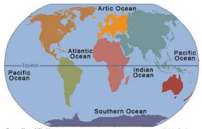
WHICH ARE THE MAJOR OCEANS?

An ocean is a huge, continuous body of salt water. Oceanographers identify five major oceans on the basis of geography and the continents that surround them. These are the Pacific, Atlantic, Indian, Arctic and Southern (also known as Antarctic) Oceans. They cover about one-third of Earth's surface and contain about 97 per cent of the world's water.

Pacific Ocean

The Pacific Ocean is the largest ocean covering more than 30% of the Earth. This is close to half of the water on Earth.

It touches the west coast border of the Americas along with east Asia and Australia.

The equator divides the Pacific Ocean into two separate parts – the North Pacific Ocean and South Pacific Ocean.

Pacific means “peaceful” in Latin. It has the deepest trenches with an average depth of 3800m.

Atlantic Ocean

The Atlantic Ocean is situated between the Americas and European/African continents. The Atlantic Ocean is the second-largest and saltiest ocean in the world.

It resembles an S-shape between the Americas, Europe, and Africa. “Atlantic” originated from the Greek god “Atlas” who carried the sky for eternity.

The ocean bottom is composed of mid-Atlantic Ridge. This submarine mountain range extends all the way from Iceland to 58 degrees South latitude. It’s part of the longest mountain range in the world.

Indian Ocean

The Indian Ocean is the third largest ocean surrounding a densely populated region. It contains an additional 20% of the water on Earth’s surface.

It borders India in the North, East Africa, Australia, and the Southern Ocean. Because of the higher water temperature, it has limited marine life.

Since about 800 A.D. the Indian Ocean has played an important role in trading. For centuries, navigators have sailed along major ocean currents for shipment routes.

It is bounded by 4 tectonics plate boundaries and may include an additional plate boundary. It is the geologically youngest of the 5 oceans with spreading ridges at divergent plate boundaries.

Southern Ocean

In 2000, the Southern Ocean is the newest ocean recognized by the International Hydrographic Organization. It borders Antarctica in its entirety.

In terms of size, it’s the fourth-largest at 20,327,000 square kilometers. It extends out to 60 degrees South latitude.

It’s an extreme environment and is the least understood of the 5 oceans. This is because it is unexplored, far from populated areas, and has a severe climate.

Despite the Southern Ocean being unexplored, about 80% of all oceans in the world are unexplored. There’s still a lot of work to do for ocean exploration.

Arctic Ocean

The Arctic Ocean is the world’s smallest and shallowest ocean of all 5 oceans. Further to this, it is the coldest and least salty ocean.

In size, the Arctic Ocean is about the size of Russia. Because it’s located at the North Pole, the Arctic Ocean has polar ice. But over the years, glaciers have melted threatening sea levels to rise.

Despite the IHO recognizing it as the “Arctic Ocean”, some oceanographers still call it the “Arctic Sea”.

The Arctic Ocean is the most diverse in terms of fish species. It has a wide variety of marine species including whales, jellyfish, etc.

But because of its frigid temperatures, it has little plant life. This makes it one of the most fragile ecosystems on the planet.

Credit: EARTHHOW

Picture Credit : Google

HOW DO WATERFALLS FORM?

A waterfall develops when the bed of the river changes from hard to soft rock. As the force of the water wears away soft rock faster, the level of the softer riverbed drops, and the river plunges over a ledge of hard rock. The depth of the fall increases over time as more and more of the soft rock is washed away.

A waterfall is a river or a body of water that steeply falls over a rocky edge into a plunge pool. These are also called cascades.

Erosion is the process of wearing away the earth. It plays an important part in the formation of waterfalls. Waterfalls also contribute to erosion.

The process of formation of waterfalls happens when a stream flows from soft rock to hard rock. This happens both laterally and vertically. In every case the soft rock erodes and leaves the hard rock as it is. Over this a stream falls.

The fall line is an imaginary line along which parallel rivers plunge while flowing from uplands to low lands. Many waterfalls in this way help the geologists determine a region's fall line and underlying rock structure.

As the stream flows it carries various amounts of sediments- be it microscopic silt, pebbles or boulders. Sediments erode the beds of soft rocks like sandstone or limestone. The stream then cuts the beds so deep that only hard rocks like granite are left.

Credit: jagranjosh.com

Picture Credit : Google

OCEANS AND SEAS ARE DIFFERENT?

The difference lies in their depth, area and variety of marine life. An ocean is deeper and covers a greater area as compared to the sea. On the other hand, a sea has more diverse plant and animal life. There are fewer plants in an ocean as there are large areas where sunlight does not penetrate. The deep-sea creatures found in the darkness of oceans are unique.


                          Sea

Ocean

Sea is also made up of salty water but is smaller in size compared to oceans.

Ocean covers approximately 70% of the earth’s total surface. Ocean is made up of salty water.

The largest sea is the Meditteranean Sea. The area of Meditteranean sea is approximately 1.14 million square miles.

The largest Ocean is the Pacific Ocean with an area of approximately 60 million square miles. The smallest Ocean is the Arctic Ocean covering an area of 5.4 million square miles.

Seas are usually located close to land.

Oceans are not necessarily located close to land.

Aquatic life exists in abundance in seas as seas are usually located close to the Land.

Oceans have reduced aquatic life as it is far away from the land and deeper than the Seas.

There is a large quantity of marine life in the Seas as sunlight is able to penetrate deeper into the seas, allowing photosynthesis.

The marine life in oceans is usually confined to bacteria, shrimp, microscopic planktons. This is due to lack of penetration of sunlight deep into oceans thus not giving much scope for photosynthesis.

Some of the major seas are Mediterranean Sea, Carribean Sea, South China Sea, Black Sea etc. The deepest sea is Carribean Sea with an approximate depth of 6900 metres.

The Deepest Ocean is Pacific Ocean which is around 10,000 metres deep and the Arctic Ocean is around 5600 metres deep.

Credit: BYJU’S

Picture Credit : Google

HOW DO RIVERS KEEP FLOWING?

Rivers are kept running by the addition of water from rainfall or melting snow. Even when it does not rain, underground reservoirs (water stores) keep rivers supplied with water and flowing. When it rains, a lot of water seeps and sinks into the ground to surface somewhere else as a spring. Over thousands of years, rivers can carve huge valleys out of solid rock with a wide floodplain, which is a flat area that catches the overflow when the river is full.

Rivers keep flowing because gravity is constantly pulling the water down the path of least resistance (downhill). A river flows because there is a water table to support it. A river is nothing more than an outward manifestation of the water table.

A river that does not run dry at any time of year is carrying surplus water from precipitation that collects in the permeable rocks of hills and mountains that surround the watershed. Most rivers get their water from the mountains, where there is far more precipitation than over the lowlands.

Credit: SidmartinBio

Picture Credit : Google

WHICH IS THE HIGHEST WATERFALL?

Angel Falls or Salto Ángel (indigenous name: Kerepakupay Vená) is the world's highest free-falling waterfall at 3,212 feet with an uninterrupted drop of 2,648 feet lying in the Canaima National Park, Venezuela. It is situated on the Churún River, an affluent of the Carrao. Curún in indigenous Pemón language means "thunder."

Angel Falls is located in the Guayana highlands, one of the five topographical regions of Venezuela. It plunges off the edge of a tepui, or table-top mountain, called Auyan Tepui (“Devils Mountain”). It is 500 feet wide at its base and in total is 15 times higher than America's Niagara Falls Angel Falls in Venezuela, which plunge 979 m vertically.

Angel Falls is one of Venezuela's top tourist attractions, despite its remoteness and the absence of roads leading to nearby villages. One of the world's great natural wonders, Angel Falls inspires feelings of awe in the hearts of those who make the journey.

Although sighted in the early twentieth century by the explorer Ernesto Sanchez La Cruz, the waterfall was not known to the Western world until it was visited in 1935 by the American aviator, James Crawford Angel, on a flight while searching for a valuable ore bed. In 1936, he returned and landed his plane at the top of the waterfall. The falls are currently named "Angel Falls" after him; interestingly, the indigenous name for the falls means "Devil's Mouth."

Credit: NEW WORLD ENCYCLOPEDIA.

Picture Credit : Google

WHICH IS THE WORLD’S LONGEST RIVER?

Flowing northward through the tropical climate of eastern Africa and into the Mediterranean Sea, the Nile river is the longest river in the world at 4,135 miles (6,650 kilometers), according to the U.S. National Park Service.

The Nile runs through Egypt, as well as nine other African nations Sudan, Eritrea, Ethiopia, Uganda, Kenya, Tanzania, Rwanda, Burundi and the Democratic Republic of Congo. More than 300 million people depend on the Nile for their water supply and the irrigation of seasonal crops, according to the Council of Ministers of Water Affairs of the Nile Basin.

The Nile's energy is harnessed by the Aswan High Dam, which was completed in 1970 and provides hydroelectricity and controls summer flooding. During the 1980s, the dam provided half of Egypt's electricity, although that amount has decreased over the years and it currently contributes 20 percent of total energy generated in Egypt, according to NASA's Earth Observatory.

Credit: LIVESCIENCE

Picture Credit : Google

HOW LOUD IS THE ROAR OF ZIMBABWE'S VICTORIA FALLS?

Victoria Falls, waterfall, c.1 mi (1.6 km) wide with a maximum drop of 420 ft (128 m), in the Zambezi River, S central Africa, on the Zambia-Zimbabwe border. The falls are formed as the Zambezi plummets into a narrow chasm (c.400 ft/120 m wide) carved by its waters along a fracture zone in the earth's crust. Numerous islets at the crest of the falls divide the water to form a series of falls. The thick mist and loud roar produced there are perceptible from a distance of about 25 mi (40 km). The Boiling Pot, the beginning of a winding gorge (c.50 mi/80 km long) through which the river flows below the falls, is spanned by a 650 ft (198 m) long bridge that is 310 ft (94 m) above the river. The gorge is now partially submerged as a result of the construction of the Kariba Dam. David Livingstone, the British explorer, visited the falls in 1855 and named them for Queen Victoria. The falls are part of two national parks and draw many tourists to the area.

Credit: Infoplease

Picture Credit : Google

WHAT IS A DELTA?

As a river reaches the sea or a lake and slows down, sediment- sand, silt and mud – builds up at its mouth, blocking its flow. The river then breaks up into several individual strands of water that make their way to the larger water body. The Nile forms a classic delta formation as the river enters into the Mediterranean Sea.

One of the first texts to describe deltas was History, written during the 5th century BCE by Greek historian Herodotus. In that work, Herodotus mentioned that the Ionian people used the term delta to describe the low-lying region of the Nile River in Egypt. During a visit to the region, Herodotus also recognized that the land bounded by the seaward-diverging distributary branches of the Nile and the sea was deltoid in shape; he is often given credit for first using the Greek letter ? (delta) to describe it. Although many of the world’s deltas are deltoid, or triangular, in shape, notable exceptions exist. In most cases, the delta shape is controlled by the outline of the water body being filled by sediments. For this reason, the term delta is now normally applied, without reference to shape, to the exposed and submerged plain formed by a river at its mouth.

Deltas have been important to humankind since prehistoric times. Sands, silts, and clays deposited by floodwaters were extremely productive agriculturally; and major civilizations flourished in the deltaic plains of the Nile and Tigris-Euphrates rivers. In recent years geologists have discovered that much of the world’s petroleum resources are found in ancient deltaic rocks.

Deltas display much variation in size, structure, composition, and origin. These differences result from sediment deposition taking place in a wide range of settings. Numerous factors influence the character of a delta, the most important of which are: climatic conditions, geologic setting and sediment sources in the drainage basin, tectonic stability, river slope and flooding characteristics, intensities of depositional and erosional processes, and tidal range and offshore energy conditions. Combinations of these factors and time give rise to the wide variety of modern deltas. The presence of a delta represents the continuing ability of rivers to deposit stream-borne sediments more rapidly than they can be removed by waves and ocean currents. Deltas typically consist of three components. The most landward section is called the upper delta plain, the middle one the lower delta plain, and the third the subaqueous delta, which lies seaward of the shoreline and forms below sea level.

Credit: Britannica

Picture Credit : Google

How are mountains created?

Most of the world’s greatest mountain ranges the Himalayas, the Andes, the Rockies, the Caucasus and the Alps were created as Earth's tectonic plates collided. As the huge tectonic masses crashed into each other, they forced the layers of rock to fold. This is why these mountains form long, narrow ranges along the edges of continents. Mountains are also created as powerful earthquakes move Earth's crust and lift up huge blocks of rock. Volcanic eruptions can also create mountains.

Mountains are formed by movement within the Earth’s crust. The crust itself is made up of several large plates, called tectonic plates, which are free floating. These huge chunks of the Earth’s crust move within molten rock called magma, which allows them to shift and collide over time. Even though humans live on the crust, they do not often feel these movements as they are very slow, and the sheer size of each plate is so large. Nevertheless, these shifts still have great impacts on human life as the movement of plates is what creates changes in the geographical structure of the surface of the earth. In this way, mountains are created over time. When these plates collide, there is a great deal of mass and pressure which suddenly comes to a stop, and it is this movement that forces the Earth into buckles or protrusions which are known as mountains. Depending on how these plates move or collide, one of three types of mountains can be formed. The three types of mountains or mountain ranges are: volcanic, fold, and Block Mountains, each of which is formed in a different way.

Volcanic Mountains:

Volcanic mountains are formed when a tectonic plate is pushed beneath another (or above a mid-ocean ridge or hotspot) where magma is forced to the surface. When the magma reaches the surface, it often builds a volcanic mountain, such as s shield volcano or a strato-volcano.

Fold Mountains:

As the name suggests, Fold Mountains occur when two tectonic plates collide at a convergent plate boundary, causing the crust to over thicken. This process forces the less dense crust to float on top of the denser mantle rocks – with material being forced upwards to form hills, plateaus or mountains – while a greater volume of material is forced downward into the mantle.

Block Mountains:

Block Mountains are caused by faults in the crust, a seam where rocks can move past each other. Also known as rifting, this process occurs when rocks on one side of a fault rise relative to the other. The uplifted blocks become Block Mountains (also known as horsts) while the intervening dropped blocks are known as graben (i.e. depressed regions).

Credit: WorldAtlas

Picture Credit : Google

WHERE DO RIVERS START AND END?

Rivers start off as small springs and streams high in the mountains. As they tumble downhill, they are joined by other streams, called tributaries, and become broader as they flow further. Upon reaching flat plains, they flow smoothly and deeply until they empty their waters into the sea or a lake.

Most rivers begin their life high up in the mountains and hills of the world. There are heavy downpours of rain here and perhaps melting snow. Some of the rain soaks into the ground and the rest runs over the surface, collects in pools, then trickles downhill with the force of gravity. Small streams are formed, which get bigger as they collect more water and join up with other streams. The ever-increasing stream wears away the ground as it goes, carving out valleys and shaping the landscape. The speed of the flowing water and the hardness of the ground have an effect on the shape created. The ‘wearing away’ is called erosion.

A mountain stream is sometimes called a youthful river and it is fast flowing, making deep valleys with steep sides. Once it begins to cut a valley it is trapped in it and will continue to carve out the same valley for perhaps thousands of years. As it tumbles downhill, the stream collects and carries rocks, stones and pebbles along with it. Progressing on its journey towards the sea, it collects more and more water until it is big enough to be called a river. Eventually, the land becomes flatter and the water flow slows down, causing the river to drop its stones and pebbles onto the river bed. This is called deposition. As an ‘old river’ meanders slowly through flat land (a bend in a river is called a meander), it is carrying only mud.

Eventually a river meets the sea and the place where it does is called the mouth. The last of the mud is deposited at the river’s mouth. A wide mouth is called an estuary. Some estuaries are enormous – the estuary of the Amazon is 333 kilometres wide!

Sometimes a lowland river winds so much that the looping meanders almost touch. The river may eventually erode away the narrow area of land between two loops so that its course runs straight and a horseshoe-shaped area of water is stranded – an ox-bow lake.

Credit: Young People’s Trust for the Environment (YPTE) 

Picture Credit : Google

NAME EUROPE'S HIGHEST MOUNTAIN?

Mont Blanc, Italian Monte Bianco, mountain massif and highest peak (15,771 feet [4,807 metres]) in Europe. Located in the Alps, the massif lies along the French-Italian border and reaches into Switzerland. It extends southwestward from Martigny, Switzerland, for about 25 miles (40 km) and has a maximum width of 10 miles (16 km). The summit is in French territory. Surrounding the massif are the Graian Alps (south), the Chamonix Valley and Savoy Alps (west), the Pennine Alps (northeast), and the Valley of Courmayeur (east). Other principal peaks within the massif include Mont Blanc du Tacul, Mont Maudit, Aiguille (“Peak”) du Géant, Les Grandes Jorasses, Mont Dolent, and Aiguille du Midi.

Glaciers cover approximately 40 square miles (100 square km) of Mont Blanc (whence its name, meaning “white mountain”). Ice streams stretch from the central ice dome down to below 4,900 feet (1,490 metres). The Mer de Glace, the second longest glacier in the Alps, reached the elevation of 4,100 feet (1,250 metres) in 1930. At the beginning of the 17th century, glaciers advanced to the bottom of the Chamonix Valley, destroying or burying cultivated land and dwellings. Since that time, the glaciers have periodically advanced and retreated.


Credit: Britannica

Picture Credit : Google

WHICH Is JAPAN'S HIGHEST MOUNTAIN?

Japan's highest mountain, peaking at 3776 m, is Mount Fuji, an active volcano that sits on a triple junction of tectonic activity. Interestingly, it is made up of three different volcanoes. At the base is Komitake, in the middle, Kofuji, and at the top is Mount Fuji. The volcano last erupted in December, 1707.

Mount Fuji is a symbol of Japan. The mountain contributes to Japan's physical, cultural, and spiritual geography.

Mount Fuji is the tallest mountain in Japan, standing at 3,776 meters (12,380 feet). It is an active volcano, sitting on a "triple junction" of tectonic activity: the Amurian plate (associated with the Eurasian tectonic plate), the Okhotsk plate (associated with the North American plate) and the Filipino plate all converge in the region beneath Mount Fuji. It is only 100 kilometers (62 miles) from Tokyo, Japan's capital and largest city. In fact, the last time Mount Fuji erupted, in 1707, volcanic ash fell on Tokyo.

Mount Fuji is the single most popular tourist site in Japan, for both Japanese and foreign tourists. More than 200,000 people climb to the summit every year, mostly during the warmer summer months. "Huts" on the route up the mountains cater to climbers, providing refreshments, basic medical supplies, and room to rest. Many people start climbing Mount Fuji at night, as better to experience sunrise from the summit—Japan, after all, is nicknamed "the Land of the Rising Sun." The sunrise from Mount Fuji has a special name, Goraiko.

Mount Fuji has been a sacred site for practicers of Shinto since at least the 7th century. Shinto is the indigenous faith or spirituality of Japan, many Shinto shrines dot the base and ascent of Mount Fuji. Shinto shrines honor kami, the supernatural deities of the Shinto faith. The kami of Mount Fuji is Princess Konohanasakuya, whose symbol is the cherry blossom. Konohanasakuya has an entire series of shrines, called Segen shrines. The main Segen shrines are at the base and summit of Mount Fuji, but there are more than 1,000 across all of Japan.

Credit: SOCIETY

Picture Credit : Google 

WHY ARE SOME MOUNTAINS SNOW-CAPPED?

As altitude increases, the air gets colder. There comes a certain height, called the snow line, above which it is always too cold for the snow to melt, which is why some mountaintops are snow-capped all year round. The snowline is at 5000m in the tropics, 2700 m in the Alps and at sea level at the poles.

The top of the mountain is actually its coldest spot. As you climb a mountain to a higher altitude (height), the atmosphere gets thinner and thinner. This is because air pressure decreases with altitude.

Even though warm air rises, as it does so the rising air expands and cools. When it expands and cools, it can't absorb and retain heat the way it does at the bottom of the mountain.

Although mountaintops are closer to the Sun, they're also farther away from the thermal heat of the Earth's core that keeps the ground warm. So the top of the mountain can be much colder than the bottom.

In fact, the bottom of a mountain can be located in a tropical jungle while the top of the mountain has snow on it! That's why it's possible to have snow at the equator.

Cooler temperatures at the top of a mountain also mean that there's less evaporation taking place. This leads to greater amounts of moisture in the air. More moisture means more rain and, at the very top of a mountain, more snow.

Not all mountains have snowcaps, and not all mountains that get snow have snowcaps all year. A lot depends upon their location and how tall they are. Mountains lower in altitude are less likely to have snowcaps or to have them all year long.

Many mountains, though, have snowcaps year-round. Above a certain point — called the snow line — it stays cold enough that the snow never melts.

The height of the snow line varies around the globe. It depends upon both altitude (height of the mountain) and latitude (where the mountain is located). The snow line is much higher near the equator (about 15,000 feet), for example, than it is near the poles (sea level or 0 feet in altitude).

The snow line can be affected by other factors, too. For example, in the Andes Mountains of South America, it is so dry that the mountains rarely see snow, despite their height and distance from the equator. Monte Pissis in Argentina is the tallest mountain in the world without a permanent snowcap.

Mountains that are near coastlines may have a lower snow line than other areas with the same altitude and latitude. As you get closer to a coastline, the amount of moisture in the air tends to produce more snowfall at higher altitudes.

Credit: Wonderopolis

Picture Credit : Google 

WHAT IS A SYNCLINE AND AN ANTICLINE?

It is important to note that syncline and anticline do not necessarily relate to the shape or orientation of folded layers, although the origin of the words implies this. The term originates from the Greek word sun (xun), meaning together, and the Greek word klei, meaning to lean, so syncline implies leaning together or leaning towards. Ant is the Greek prefix meaning opposite or opposing, so the word anticline implies oppositely leaning. Beds dip towards the fold axis in a syncline and away from the fold axis in an anticline only when the folded layers were upright before folding (i.e., where younger layers overlaid older layers). Before describing folds, it is therefore necessary to establish the primary order in which layers were deposited. To do this, facing, younging, or way-up criteria are used. These are synonymous terms for primary sedimentary structures (e.g., graded or cross-bedding) or igneous structures (e.g., vesicles, pillows) preserved in the folded layers. Where the relative ages of rocks are not known (as is often the case in metamorphic rocks), the term synform and not syncline should be used to describe folds where layers are bent downwards so that they dip towards the fold axis, and antiform and not anticline should be used where beds are arched upwards so that layers dip away from the fold axis.

Where rock layers have been inverted prior to folding, such as by folding about a larger fold with a shallowly inclined axial surface, the oldest rocks now occur in the core of folds where layers dip towards the fold axis. Such folds are called synformal anticlines; synformal because of their shape and anticline because of the relative ages of folded layers. The youngest layers in an overturned sequence occur in the core of folds called antiformal synclines where layers dip away from the fold axis.

Credit: ENCYCLOpedia.com

Picture credit: Google

WHICH IS THE WORLD'S HIGHEST MOUNTAIN?

Mount Everest in the Himalayas in Asia, with its peak at 8848 m above sea level. Mount Everest, China-Nepal border Syncline Anticline.

If you ask almost anyone to name the highest mountain in the world, their answer will probably be "Mount Everest." Mount Everest, located on the border between China and Nepal, has an altitude of 8,848.86 meters (29,031.69 feet) - making it the highest mountain in the world. The altitude of 8,848.86 meters is officially recognized by China and Nepal. Both countries agreed to use the elevation of the mountain's snow cap, rather than a bedrock elevation of 8,844 meters.

Mount Everest is called the world's highest mountain because it has the "highest elevation above sea level." We could also say that it has the "highest altitude."

The peak of Mount Everest is 8,848.86 meters (29,031.69 feet) above sea level. No other mountain on Earth has a higher altitude. However, some mountains might be considered "taller" (with taller being "the total vertical distance between their base and their summit")

Credit: Geology.com

Picture credit: Google