Why are the Ural Mountains important?

The Ural Mountains, or the Urals, are found in Russia and mark Europe’s eastern continental border with Asia. They were formed between 250 and 300 million years ago due to continental collisions.

These mountains form a natural divide between Europe and Asia and separate Russia into western Russia and eastern Russia. Western Russia lies in Europe and Eastern Russia, also called Siberia, lies in Asia.

The Urals are rich in mineral and metal deposits and are part of a highly developed industrial complex. They are divided into five sections. The Polar Urals, Subpolar Urals, Northern Urals, Middle Urals and the Southern Urals.

Picture Credit : Google

Why do we say that the beauty of the Rockies is well protected?

To protect the Rockies from commercial and economic exploitation, they have been divided into many national parks. This ensures that these mountains are protected with many controls in place regarding what may and may not be done in these areas.

These parks are known for their magnificent beauty and receive millions of visitors every year. Activities carried out here are done in harmony with nature and resorts and hotels use clean energy sources and encourage guests to be environment friendly.

One of the best known of these parks is the Yellowstone National Park in Wyoming, USA. At an elevation of 2,438 m, Yellowstone was the first national park to be established in the USA in 1872. Yellowstone’s natural forest cover extends nearly 9,000 sq km and comprises lakes, canyons, rivers and mountain ranges. It is home to 67 species of mammals including grizzly bears, wolves, bison and wapitis, as well as 300 species of birds and 6 species of reptiles.

It is centred on the Yellowstone caldera, the largest supervolcano on the continent. Yellowstone also has the world’s largest concentration of geysers. More than 300 geysers are found here, including ‘Old Faithful’ one of the most well-known geysers which has erupted every 44 minutes to 2 hours since 2000!

Picture Credit : Google

Where are the Rocky Mountains located?

The Rocky Mountains, or Rockies, are located on the western side of North America. They extend 4,800 km from the northern part of British Columbia in Canada to New Mexico in south-western United States. The Rockies have some of North America’s highest peaks.

The highest peak in the Rockies is Mt. Elbert in Colorado which is at an elevation of 4,401 m. It was first summited by Henry W Stuckle in 1874 and is often referred to as a ‘gentle giant’, as it is relatively easier to climb than other mountains in the same category.

The Rockies comprise at least 100 separate ranges and are divided into four sections. These are the Southern Rockies, found mainly in Colorado and New Mexico; the Middle Rockies found in Wyoming, Utah and south eastern Idaho; the Northern Rockies in Montana and north east Idaho; and the Canadian Rockies in British Columbia and Alberta.

Did you know that a super volcano lies hidden in the Rocky Mountains? The volcano is located in the Yellowstone National Park and is called the Yellowstone Caldera. This is one of the reasons why you can see geysers in Yellowstone, and why there is an overpowering smell of phosphor in the air throughout the national park.

Picture Credit : Google

Why does the climate in the Rockies vary greatly?

The Rockies have a cold steppe climate with everlasting snow in the higher areas. The weather can change rapidly depending on altitude and latitude of the region. The windward side gets more rain than the leeward side. In general the summers are warm and dry but mountain rain and thunderstorms can occur, while winters are very cold with a lot of rain and snow.

Climate in the Rockies varies from the frozen wastelands of Alaska in the north to sunny Mexico in the south. The Rockies affect the climate of the North American continent by acting as a barrier to rain bearing winds. As a result, in the south the climate tends to be dry, especially in the rain-shadow valleys. The San Luis Valley in Colorado, for example, has a mountain-desert climate and is one of the driest areas of the Rockies. The Northern Rockies tend to receive rain and snow more evenly throughout the year from Pacific cyclonic storms.

Picture Credit : Google

What is the climate of the Alps like?

The unique location of the Alps allows for the interplay of several factors that have resulted in huge variations in climate here. Different types of winds converge and play a prominent role in the daily weather and microclimate conditions of the Alps.

Four kinds of wind influence the climate on the Alps. Mild, moist air of the Atlantic pours in from the west. Cool polar air blows down from northern Europe. Continental air masses, that are cold and dry in winter and hot in summer, play a big role in the eastern regions of the mountains, and from the south, warm Mediterranean air flows northward into the Alps.

Daily weather on the Alps is also influenced by the location and passage of cyclonic storms, as well as the direction of the winds as they pass over the mountains.

The Alps are split into 5 climatic zones in which the weather varies: The colline zone lies between 500 m and 100 m. The montane zone lies between 800 m and 1.700 m. The sub-alpine zone is found between 1,600 m and 2,400 m, while the alpine zone extends from the treeline to the snowline. The glacial zone covers the glaciated areas of the mountains.

Picture Credit : Google

Which are the notable mountains in the Alps?

The Alps are the longest and highest mountain range in Europe. The name Alps most likely comes from the Latin word ‘albus’ which means ‘white’. These mountains have 82 official summits of 4,000 m and above. All these peaks, also referred to as ‘four-thousanders’, are located within France, Italy or Switzerland.

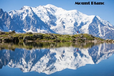
The highest of the four-thousanders is Mont Blanc which rises to 4,807 m. Mont Blanc means White Mountain, both in French and Italian. It is named so because it is covered in heavy snow all year round. Mont Blanc is part of the Mont Blanc massif (group of mountains) which contains eleven major independent summits, each over 4,000 m in height. Mont Blanc was first summited in 1786 by Jacques Balmat and Michel-Gabriel Paccard.

Monte Rosa lies between Italy and Switzerland. At 4,634 m, it is the second highest mountain in the Alps and the highest in the Swiss Alps, which has 10 peaks higher than 4,000 m. Monte Rosa was first summited in August 1855 by a group of alpinists.

Another notable mountain is the Matterhorn. It lies on the border between Italy and Switzerland and is Switzerland’s most famous mountain. At 4,478m the Matterhorn is one of the highest mountains in the Alps. The mountain’s four sides face the four cardinal directions- north, south, east and west. It was first summited in 1865 by a group of mountaineers. Around 500 alpinists have died trying to climb the Matterhorn, making it one of the deadliest peaks in the world.

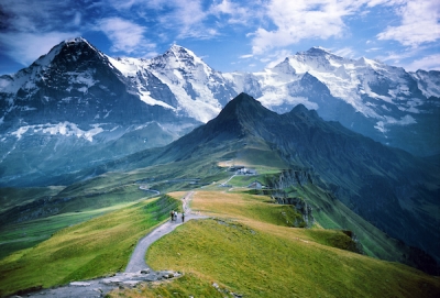
Jungfrau, which falls in Switzerland, is one of the main summits of the Bernese Alps (Jungfrau’s parent range). The mountain is 4,158 m tall and is located between the northern Canton of Bern and the southern Canton of Valais. Jungfrau was first summited in August 1811 from the eastern side by two Swiss brothers named Rudolf and Hieronymus Meyer.

Picture Credit : Google

How were the Alps formed? Why is it said that the Alps boast of an incredibly complex topography?

Millions of years ago, the map of the world was very different. There were different land masses and different water bodies on the Earth. One such water body was called the Tethys Ocean. A part of this ancient and mighty ocean lay between Africa and Europe.

Around 180 million years ago, the continent of Africa began slowly pushing into southern Europe. This caused the Tethys Sea to drain away in that region and the underlying seabed was lifted up along with parts of the Earth’s crust to form the Alps.

This process took many millions of years and the Alps are still growing to this day, as movements of the Earth’s crust continue, pushing them upwards bit by bit.

The Alps are the highest mountains in Europe with a variety of elevations and shapes. They exhibit an incredibly complex topography with majestic peaks, lakes, glaciers, waterfalls and ice-scoured valleys cradling alpine forests and pristine meadows.

Picture Credit : Google