The Intergovernmental Panel on Climate Change's (IPCC) Sixth Assessment Report (AR6) 'Climate Change 2021: The Physical Science Basis' was released recently. The report was approved by 195 member governments of the IPCC through virtual sessions held over two weeks in July and August. The report pointed out that every region in the world is witnessing irreversible changes in climate due to human influence. Sea level rise, floods, heavy rainfall and glacier melting are some of these irreversible effects. The report warned that extreme sea level events that previously occurred once in 100 years could happen every year by the end of this century.
Using the extensive data on future sea level rise from the IPCC, the National Aeronautics and Space Administration (NASA) of the United States has created a visualisation tool accessible to the public. The tool allows users to view both global and regional sea level projections from 2020 to 2150, along with how these projections differ depending on future scenario. Users can click on a point anywhere in the ocean to obtain the IPCC projection of sea level for that individual location.
As for India, the NASA tool predicts some grim future. The rising sea level threatens to submerge at least 12 coastal cities in the country. What are these cities and how grave is the threat? What causes sea level rise?
What does the tool predict for Indian cities?
From Okha in Gujarat to Khidirpur in Kolkata, the NASA tool offers sea-level projection for 12 Indian coastal cities, which are likely to sink nearly three feet underwater by 2100. Refer the table here to see how your city fares.....
What does the report say about global sea level rise?
By 2100, the global mean sea level will rise between 1.3 feet and 2.6 feet. How high the seas rise depends on how much and how quickly we manage to cut greenhouse gas emissions, the report says.
What is the IPCC report all about?
The Intergovernmental Panel on Climate Change is a climate-science-focused organisation of the United States. It's been around since 1988, and it has 195 member countries. Every seven years or so, the IPCC releases a report summarising the most up-to-date, peer-reviewed research on the science of climate change, its effects and ways to adapt to and mitigate it.
The purpose of these reports is to provide everyone, particularly governing bodies, with the information they need to make important decisions regarding climate change. The IPCC essentially provides governments with thousands of papers published regarding the science, risks, and social and economic components of climate change.
The report released this month was authored by 234 scientists nominated by IPCC member governments around the world. These scientists are Earth and climate science experts.
What causes sea-level rise?
Global warming: The burning of fossil fuels, deforestation, decomposition of waste in landfills and livestock have released enormous amounts of greenhouse gases into the atmosphere. These emissions have caused the Earth's surface temperature to rise, causing global warming, which leads thermal expansion and melting of glacier, and thereby directly contribute to sea-level rise.
Thermal expansion
The oceans are absorbing more than 90% of the increased atmospheric heat associated with greenhouse gas emissions. When water heats up, it expands. The ocean water expands to fill a greater volume and takes up more space. This is called thermal expansion, and it is responsible for one-third of the sea-level rise, according to studies.
Melting of glaciers and ice caps
Warmer temperatures cause land-based ice, such as glaciers and ice sheets to melt, and the meltwater flows into the ocean to increase sea level. Melting ice causes about two-thirds of the rise in sea level.
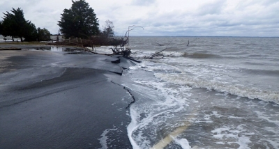
How does sea-level rise impact coastal regions?
- The impact of sea-level rise includes flooding of coastal areas, increased soil erosion, disappearance of low-lying islands, saltwater intrusion and habitat destruction in coastal areas. Rising sea levels also make storm surges capable of much greater damage. (Storm surge is the abnormal rise in seawater level during a storm. Storm surge can penetrate well inland.)
- Higher sea levels are coinciding with more hurricanes, contributing to more powerful storm surges that can strip away everything in their path.
- Saltwater intrusion is the flow of seawater into water bodies such as rivers and aquifers (underground waterbearing rocks). It is a major concern as it can induce contamination of water resources, used for drinking, household purposes and agriculture. Increased salinity of coastal freshwater can threaten vegetation and wildlife of the region.
- Many birds use coastal ecosystems to find food, live and breed. Sea turtles lay their eggs on beaches, returning to the same location every year. When beaches erode, these animals and birds will be affected.
- Islands and island life will be particularly affected due to sea level rise.
- Rising sea levels will lead to the displacement of people. It could create 187 million climate refugees by 2100, according to a study.
What are the important takeaways from the report?
- The report says almost all of the warming that has occurred since pre-industrial times was caused by the release of heat-trapping gases such as carbon dioxide and methane. Much of that is the result of humans burning fossil fuels - coal, oil, wood and natural gas.
- The global temperatures have already risen by 1.1 degrees Celsius since the 19th century, reaching their highest in over 100.000 years, and only a fraction of that increase can have come from natural forces.
- The report concludes that ice melt and sea level rise are already accelerating. Wild weather events from storms to heat waves are also expected to worsen and become more frequent.
- Even if emissions are drastically cut, some changes will be "irreversible" for centuries, the report said.
- While many of the report's predictions paint a grim picture of humans' impact on the planet and the consequences that will have going forward, the IPCC also found that so-called tipping points, like catastrophic ice sheet collapses and the abrupt slowdown of ocean currents, are "low likelihood," though they cannot be ruled out.
- Although temperatures are expected to overshoot the 1.5 degree Celsius target in the next decade, the report suggests that warming could be brought down through "negative emissions." (Negative emission is the removal of more carbon dioxide out of the atmosphere than is added) But many scientists are sceptical about this mitigation measure.
- The assessment shows the ocean surface has warmed slightly less, by about 0.9 degree Celsius as a global average, than the land surface since 1850, but about two thirds of the ocean warming has taken place during the last 50 years. It is certain that the heat content of the ocean will continue to increase until at least 2300, even under low emissions scenarios.
- Carbon dioxide emissions are the main driver of acidification in the open ocean, Oxygen levels have dropped in many ocean regions since the mid 20th century and marine heatwaves have doubled in frequency since 1980, also becoming longer and more intense, says the report.
Picture Credit : Google