What are the major threats faced by the rainforests of the Nicobar Islands? Name some protected areas in the islands.

Have you ever wondered how difficult it would be if wild animals invaded your cosy little house? What if they started living in it without your consent?

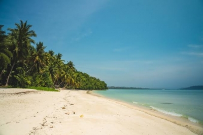
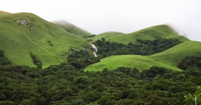
Rainforests are to plants and animals what homes are to us: a refuge, a shelter, and a peaceful place to eat.

Rainforests are cleared extensively to create space for cultivating essential crops. Trees are cut for fuel, cattle are grazed in forests, and large areas are burned to grow better grass for cattle feed. Exotic plants and animals are hunted for the pet and ornament market. Such conversion of natural habitats to suit Man’s needs defines the gravity of destruction caused to the rainforests.

Thankfully, Nicobar Island was declared as a biosphere reserve by the government in 1989 and was later included in UNESCO’s biosphere programme. Today, about 57 per cent of the island’s total area has been protected, the most important being the Campbell Bay National Park and the smaller Galathea National Park.

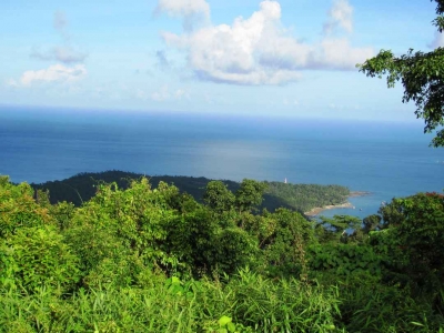
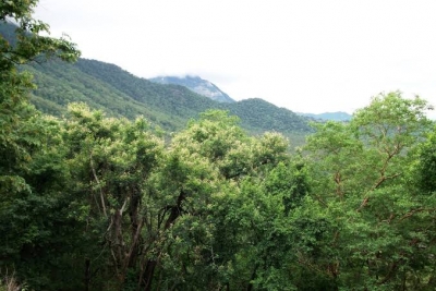
The Campbell Bay National Park received its status in 1992. It is located on the Great Nicobar Island and forms part of the Great Nicobar Biosphere Reserve, a perfect ambience for the growth of various endemic species.

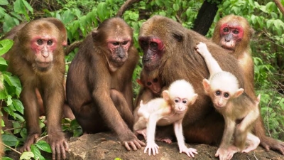
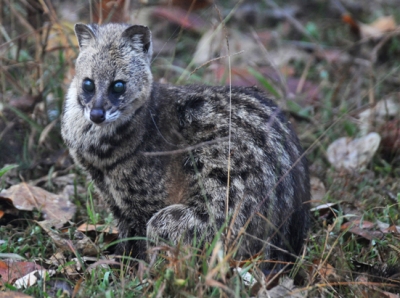
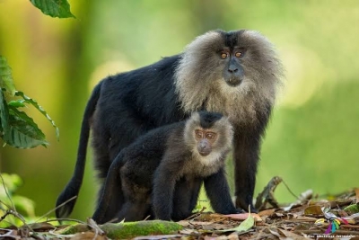
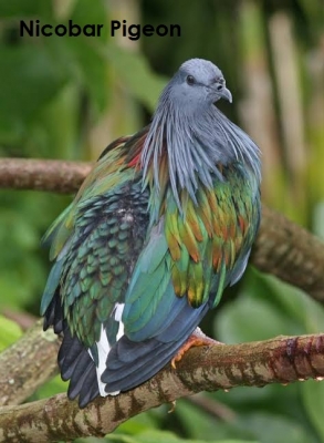
The Galathea National Park is separated from the Campbell Bay National Park by a 12 km wide forest buffer zone. The Park has substantial tropical and subtropical moist broadleaf forests, and its notable fauna species include the Giant robber crab, the Nicobar pigeon, and Megapodes, which are chicken-like birds. This Park is also home to the Shompens, a vulnerable tribal group of hunters and gatherers that survive on forest resources alone.

Picture Credit : Google

What are some of the endemic species of the Andaman Islands' rainforests?

Sometimes, ‘small’ can be ‘big’. The Andaman island rainforests may be much smaller in area when compared to the Western Ghats or the North-eastern rainforests of India. They do not have a rich distribution of large-sized animals either. But this should not be used as a measuring stick to determine the species abundance of the land.

Endemism is truly remarkable in this region, be it birds, reptiles, amphibians, or mammals.

Birds highly indigenous to this particular ecosystem are the Andaman crake, the Andaman serpent-eagle, the Andaman coucal, Andaman woodpecker, Andaman scops owl, Andaman drongo, and Andaman treepie.

Among the 45 reptiles recorded, 13 species are natives of this ecoregion, the most striking of which is the bright green, slender lizard called the Andaman day gecko. Seven out of the 12 amphibians listed are also indigenous to these islands.

As for its mammals, five small species are indigenous and listed as Vulnerable or Threatened under the IUCN Red List. They are the Andaman spiny shrew, Jenkin’s Shrew, the Andaman rat, the Andaman horseshoe bat, and the white-toothed shrew.

Sadly enough, the Andaman rainforests are prone to natural calamities such as cyclones and tsunamis. Artificial destruction resulting from clearing lands for agriculture and human habitation has also adversely impacted this beautiful land’s rich endemism.

Picture Credit : Google

What are the rainforests of Nicobar Islands known for?

The Nicobar Islands find their place across the Indian Ocean, lying between Sumatra to the South and the Andamans to its North. Believed to have been formed by volcanic activity, these islands have existed in isolation from the mainland for years. Hence, flora and fauna are diverse and primarily endemic.

Tropical moist broadleaf trees sketch the Nicobar Islands rainforests. The south-west and the north-east monsoon winds control these rain forests’ average temperature by causing heavy showers for many months. Cyclones and thunderstorms also frequent these islands.

A majority of the mammals are small in size. The Nicobar flying fox, the Nicobar tree shrew, and Miller’s Nicobar rat are the small-sized currently threatened and vulnerable species. Among the larger mammals are the Asian elephants, the spotted deer, and the endemic Nicobar wild pig.

The endemic birds include the Nicobar sparrow hawk, the great Nicobar serpent eagle, the Nicobar parakeet, and the sizeable Nicobar pigeon, closely related to the extinct dodo. The white-sand beaches that border the rainforests serve as nesting sites for green turtles, hawk bills, and leatherbacks.

Picture Credit : Google

Why are the north-eastern rainforest areas decreasing? What are its effects on the ecosystem?

Northeast India is a forest surplus region. Its dense forests cover 64 per cent of the total geographical area. But an alarming decrease of 1800 sq. km. of the forest cover was observed between 1991 and 1999. Much of the dense canopy structures have also degraded into open forests that consist primarily of thorny scrub vegetation, thus creating more barren and unfertile wastelands than ever.

The Brahmaputra and Barak river valleys are fertile and fit for cultivation, but the rest remain arid and useless for permanent cultivation. The lack of availability of fertile plains for more extended periods led to the slash and burn agricultural practice called shifting cultivation, or Jhum cultivation. Although this practice has lots of benefits, its harmful after-effects tend to be more pronounced.

Initially, shifting cultivation was done in cycles of 15-20 years. It has now been reduced to cycles of 2-3 years which requires more forest area. This leads to loss of trees, thereby depleting the soil of its nutrients.

You have learned how forests help in preventing floods by holding the soil firmly by its roots. The Assam rainforests, too, were once natural sponges that absorbed much of the surplus monsoon rains. The Brahmaputra River that flows through these rainforests helps to remove this surplus water by draining it into the Bay of Bengal. The loss of the forest cover causes the Brahmaputra to flood its banks, a phenomenon that has now become a yearly affair, creating havoc and destruction to lives and property.

Picture Credit : Google

What are the features that define the stump-tailed Macaque?

Try to picturise a monkey in your mind that has a furry dark brown body, a teeny-weeny tail just about 2 inches long, and a hairless, red coloured face as if dipped in a can of red paint!

The stump-tailed Macaque, also known as the bear Macaque, is a primate predominantly found in the tropical and subtropical forests of Asian countries such as Cambodia, China, Northeast India, Myanmar, Thailand, Vietnam, Laos, and northwest Peninsular Malaysia.

These Macaques generally have a large body structure. Males can be as large as 65 cm in length and weigh up to 12 kg. Females are relatively smaller. Owing to its large body size, the stump-tailed Macaque is a lazy tree climber and uses the trees only to relish the fruits or sleep at night. Males climb more often to look out for potential danger and to keep watch over the troop.

The undisturbed rainforests of the tropics provide these primates the much-needed food, nutrition, and shelter and hence are crucial for their survival. Although they are known to live up to 30 years, threats such as poaching, habitat loss, and natural predators have considerably shortened the lifespan of these animals in the wild. The IUCN Red List of Threatened Species has listed these animals as ‘Vulnerable’and foresees an alarming population dips in the coming years.

Picture Credit : Google

Why are the rainforest of the Andaman and Nicobar Islands said to be unique? How are the Andaman Islands different from the Nicobar Islands?

India’s Andaman and Nicobar Islands are an extensive group of 572 small islands (archipelago) in the great Indian Ocean. The Andaman group consists of 325 islands, while the Nicobar group has 247 islands. The human population is present only in some of these islands.

The Andaman Islands are separated from the Nicobar groups by a 150 km wide channel known as the Ten Degree Channel.

A favourite international tourist hotspot, this archipelago is highly reputed for its mangroves, coral reefs, white-sand beaches, and most importantly, its rainforests.

These beautiful tropical rainforests of India boast a unique and abundant species of exotic flora and fauna. About 2,200 plant varieties have been discovered to date, of which 200 are highly endemic, and 1,300 do not even exist in mainland India!

The Andaman Islands are called veritable storehouses of plant biodiversity. About 10 per cent of the total 2,500 flowering species spotted here are indigenous to these islands alone. Its floral wealth displays stronger affinities and similarities to those in northeast India, Myanmar, and Thailand. This is because the Andamans were once part of the continental landmass that later got separated.

However, it is believed that the Nicobar Islands took shape because of some very ancient volcanic activity. Its flora shows significant similarities with that of Malaysia and Indonesia.

Picture Credit : Google

What is a Nilgiri Tahr?

The Nilgiri Tahr is an endangered ungulate (large mammal with hooves), which is the state animal of Tamil Nadu. Herbivorous in nature, they prefer grassland habitats with steep rocky hills and are endemic to the Nilgiri hills and other parts of the Tamil Nadu-Kerala Western Ghats.

These goat-like mammals are closely related to sheep. The body is broad and sturdy, and the fur is coarse and bristle-like. The curly sharp horns vary in length depending on the gender. Males grow longer horns than females and can measure up to 40 cm. They also grow darker as they mature and are bulkier and taller than the females. Some healthy members can weigh up to 100 kg and attain a shoulder height of 100 cm. In contrast to their dark-coloured bodies, male Tahrs develop a light grey patch on their backs that look like natural saddlebacks!

The Eravikulam National Park in Kerala has the highest density and largest living population of the Nilgiri Tahrs, second to which is the Anamalai Tiger Reserve in Tamil Nadu.

One may find these cliff climbers only in restricted ranges, but their role in balancing the ecosystem is undeniable.

As with the other endangered species, the Nilgiri Tahrs, too, are subject to constant threats such as poaching, livestock overgrazing, and encroachment of different animal species into their habitats, which is why their global population has considerably dwindled to about 2000 or 3000 in number.

Picture Credit : Google

Why are the north-eastern rainforests of India significant?

If you thought that the mesmerizing beauty of the rainforests of the Western Ghats is unrivalled, you probably are wrong! The rainforests of north-eastern India are perhaps the most captivating of all rainforests, thanks to their comparatively lower density of human inhabitants!

These Indian rainforests stretch across the six eastern states of northern Assam, Nagaland, Manipur, Mizoram, Tripura, and part of Arunachal Pradesh. Most of this area is at an altitude of around 900 metres. It serves as a haven to several evergreens and semi-evergreen rainforests, moist deciduous monsoon forests, riparian (wetland) forests, swamps, and grasslands.

The evergreen rainforests of Northeast India spread their foliage in the wet valleys of Assam, the foothills of the eastern Himalayas, lower parts of the Naga Hills, Meghalaya, Mizoram, and Manipur, owing mainly to the heavy rainfalls received in these regions.

These areas are renowned for their moist monsoon forests that abound in precious sandalwood and rosewood trees and, of course, the Sal trees.

The Joy-dihing wildlife sanctuary of the upper regions of Assam comprises the Joypur reserve forests, Dirak reserve forests, and Dihing reserve forests. The Sanctuary is home to a wide range of primate species like the Rhesus Macaque, Assamese Macaque, Capped langurs, Slow loris, Pig-tailed Macaque, Stump-tailed Macaque, Hoolock Gibbons, and also a large elephant population.

Picture Credit : Google

Are there many endemic species in the montane and deciduous forests of the southern Western Ghats?

The cool and wet climate of the montane forests supports a wide variety of animal and plant species. The bio-system is richly endemic to many exotic species.

The montane rainforest trees are mostly evergreen. A few notable canopy trees characteristic to these forests include the wild durian, Ceylon ironwood, and Nageia. These wooded ecoregions are well-known for their fauna richness too. Of the total 78 mammal species found, ten are endemic.

The Asian highland shrew, Salim Ali’s fruit bat, Nilgiri langur, Malabar large-spotted civet, and the Nilgiri long-tailed tree mouse are just a few of the animal species found here. Other notable animals include the elephant, tiger, sloth bear, wild dog, leopard, and the endemic species like the Nilgiri tahr, the Nilgiri Macaque, and the lion-tailed Macaque. Of the 309 bird species, 13 species show endemism, including the Nilgiri wood-pigeon, Malabar grey hornbill, white-bellied treepie, and the white-bellied shortwing. The Aralam Wildlife Sanctuary, the Brahmagiri Wildlife Sanctuary, and the Indira Gandhi National Park are some of the notable forest conservation areas in the southern Western Ghats.

The trees of the southern Western Ghats’ deciduous forests are luxuriantly diverse. The mammals found are not strictly endemic and are more or less the same as in the montane ranges. The smaller threatened species of mammals include Jerdon’s palm civet, the grey slender loris, and the grizzled giant squirrel.

The Nilgiri wood-pigeon, the grey-headed bulbul, and the Rufous babbler are just a handful of the 322 native bird species of the ecoregion. Some of the critical protected forest reserves in the area are the Bandipur National Park, the Chinnar Wildlife Sanctuary, and the Eravikulam National Park.

Picture Credit : Google

What are the specialities of the Malabar large-spotted civet?

A civet is a nocturnal carnivorous mammal that resembles a raccoon. They share several similarities with cats.

The Malabar large-spotted civet, known as the Malabar civet, is a civet indigenous to the Western Ghats. Its notable features are the white throat and neck, the mane between the shoulders, and the tail with dark ringed bands. These mammals are dark-grey and spot a black mark on the cheeks. Large cross-marks define the back of the body, and the sides flaunt obliquely patterned dark shades.

The species flourished until the 19th century. They could be seen aplenty in the rich wooded lowlands, the elevated forests of the Ghats, and along the stretches of the Malabar Coast and in parts of the old Travancore state.

The population of the species started to decline after being hunted for its musky secretion, which formed a primary aromatic ingredient in the perfume industry.

Widespread deforestation at the beginning of the 20th Century almost pushed the animal to extinction. Thankfully, the animal was spotted both in 1987 and recently, during the Covid lockdown, wandering around an abandoned street in a town in Kerala.

The surveys conducted between 1990 and 2014 have not recorded the presence of the animal at all. It has been listed as Critically Endangered on the IUCN Red List because of its alarmingly low numbers.

Picture Credit : Google

Why is the lion-tailed Macaque of the Western Ghats interesting?

Far away in the jungles of the Western Ghats, is a little black ‘lion’. He is called so because of his head and the tuft on the tail! The canines in his mouth can bring shivers to your bones, and so can his cry, fierce and mighty! But afraid of the nights, he lives on top of trees, is shy as a squirrel and eats nothing but fruits!

The lion-tailed Macaques, also known as Wanderoos, are a species of monkeys endemic to the Western Ghats.

Identifying a lion-tailed Macaque from other monkeys is child’s play. Its body is hairy and dark. The dark hairless face centres a silver-white mane, and the tails have a tufted tip, both traits resembling the lion. The trunk is haired, but not the face. It is black and boasts long and sharp canines inside the mouth.

The lion-tailed Macaques are diurnal and arboreal, and feed mainly on fruits, leaves, buds, and insects. They are endemic to the tropical rainforest regions of Tamil Nadu, Kerala, and Karnataka and appear in groups of about 20 members.

Good defenders of their territory, they engage in fierce brawls and loud cries when threatened. Agriculture, dams, and tea/coffee plantations have pushed down their population to being ‘endangered’ according to the IUCN Red List.

Picture Credit : Google

What can you say about the montane forests and their surrounding deciduous forests of the southern Western Ghats?

The montane and deciduous rainforests of the southern Western Ghats are in many ways mirror reflections of their northern counterparts because of their similarities. However, they also differ in many aspects such as location, area covered, and endemic flora and fauna.

The southern montane forests of the Western Ghats are spread over the south Indian states of Karnataka, Kerala, and Tamil Nadu, at heights of over 1000 metres. These forests receive heavy rainfall from June till November because of the south-west and northeast monsoon winds. The climate is more stable than in the deciduous forests and it is also the wettest region in the Indian peninsula. These montane forests span an area of 22,600 sq. km, much of which has now been cleared by humans.

Surrounding these mountainous forests on both the western and eastern slopes lie the deciduous forests of the southern Western Ghats. They cover an area of 23,800 sq. km and are thick with tropical moist broadleaf trees. Climate is tropical and humid and varies according to elevation. The higher you climb, the cooler it becomes! Just like the northern deciduous forests, the western slopes receive higher rainfall than the eastern slopes.

Best known spots of the southern Western Ghats are Agastyamalai, Aanamalai, the Palani Hills, the Cardamom Hills and the Nilgiri Hills.

Picture Credit : Google

How do the Western Ghats define the identity of India?

India has many breath-taking hill stations from north to south that draw in thousands of tourists every year. Among these hill stations, a few hold a special place in the hearts of avid travellers from all across the world. Munnar, also known as the ‘Kashmir of South India’ and others such as Ooty, Kodaikanal, and the Nilgiri hills are genuine paradises on Earth.

Also known as Pashchim Ghat or Sahyadiri, the Western Ghats are a long chain of mountain ranges that run from north to south along the western border of the Indian peninsula. The mountains stretch 1,600 km, beginning from Gujarat, and pass through Maharashtra, Goa, Karnataka, and Kerala before it ends in Tamil Nadu. The Aanamudi of Kerala, the highest peak in the Western Ghats, is known as the Everest of South India!

Beneath the green blanket of these majestic hills lies an entirely spectacular world teeming with exotic plant and animal life!

According to UNESCO, these World Heritage sites are older than the Great Himalayas, and are among the world’s eight most important hotspots! Apart from the thousands of plant and animal species discovered these terrains are abode to at least 325 globally threatened species and are indeed rivals of the great Amazonian rainforests!

The Western Ghats come between the Konkan Coast of the Arabian Sea and the peninsular Deccan Plateau. Its rainforests are vital in deciding the annual Indian monsoon patterns. Over 40 per cent of India’s river systems pass through these catchments before draining out into the Arabian Sea. The northern Western Ghats and the southern Western Ghats each have two types of forests, the moist deciduous forests and the montane forests.

Picture Credit : Google

The montane rainforests and deciduous rainforests of the northern Western Ghats are similar yet strikingly different. How?

Montane in Latin means mountain. The northern Western Ghats rainforests, both montane and deciduous, cover the northern parts of the Western Ghats and spread across Gujarat, Maharashtra, Goa, and Karnataka.

Both forest types have mostly tropical moist broadleaf trees. The bio-diversities of both the woods are astoundingly remarkable, and a substantial percentage of the country’s flora and fauna are endemic to these regions.

The montane rainforests cover 30,900 sq. km at an elevation of 1000 metres, and the forest trees are primarily evergreen and multi-storeyed.

Trees as tall as 45 m and various climbers, lianas, and epiphytic plants form the canopy’s upper layer network. The lower shelters consist of bamboos, palms, and canes. The thickness of foliage decreases as heights increase and gives way to hilly grasslands with patches of stunted forest growth, called Shola forests.

Many of the forest’s endemic fruit-eating birds like the Nilgiri wood-pigeon, Malabar grey hornbill, grey-headed bulbul, and the Malabar parakeet help maintain the forest architecture. The 138 species of frogs seen here are found nowhere else on the planet, and include the pig nose, an endangered living fossil that dates back to the Jurassic period!

The moist deciduous forests cover the eastern and western mountain slopes and surround the montane rainforests from a lower altitude. This ecosystem covers 48,200 sq. km, from the southern borders of Gujarat’s Gir forests and ending with the south Karnataka forests.

The deciduous forests are tropical and humid. The western slopes receive higher rainfall because of the blocking of the south-west monsoon winds, and the eastern slopes receive lesser rain because of the rain shadow caused by the same. The forest is characterized by several plant varieties, including teak and the Indian thorny bamboo. Many of its endemic plants have medicinal properties. Fauna species include the endangered lion-tailed Macaque, tiger, common leopard, Asian elephant, Indian bison, and sloth bear. Endemism is more pronounced in its bird species, including the spot-billed pelican, the lesser frolican, and three varieties of hornbills.

Picture Credit : Google

Why is the role played by non-profit organizations vital in tackling rainforest conservation?

Man can thrive only if Nature thrives. This realization has seen the sprouting and growth of several non-profit organizations that function solely for the benefit of nature. Two such critical non-profit organizations are the Rainforest Trust and The Rainforest Alliance.

The Rainforest Trust is a U.S. - based, highly transparent, and efficient non-profit organization functioning over the past 30 years with a mission to save endangered wildlife. The organization purchases rainforest areas that are threatened. It then ensures the protection of the land by entering into a partnership with conservation groups worldwide. The community is also engaged in the entire process.

A few of its notable conservation projects are the Jocotoco Conservation Foundation Project to save Ecuador’s endangered bird and animal species, and the partnership project with Burung Indonesia, to conserve Asian bird species.

Rainforest Alliance is yet another international non-profit organization that uses social and market forces to protect forests and their inhabitants. The Rainforest Alliance seal, which appears on products made from farm and forest products, is seen more or less as a valid symbol of sustainability. Various tourism businesses also use this seal as a certification for their various educational programmes on sustainability.

Businesses and start-ups that foster this sustainability are encouraged by many countries. For example, the agreement signed between the Costa Rican government and the American pharmaceutical company, Merck, ensures that a share of the profit gained from extracting its rainforest medicinal compounds is used to fund conservation projects. The country also invests in ecotourism projects to financially benefit the local economies.

At the global level, The United Nations’ REDD (Reducing Emissions from Deforestation and Forest Degradation) Program offers financial support to 58-member countries. The fund is used to mitigate the extent of carbon emissions created by deforestation activities within these countries. Using this fund from REDD, the Democratic Republic of Congo has created an online National Forest Monitoring System that tracks and maps data on any deforestation activities happening in its protected areas and monitors measures under-taken by the national forestry department.

Picture Credit : Google