Which is the fifth-longest river system in the world?

The Yenisei is the greatest river system flowing to the Arctic Ocean, and the fifth longest river in the world. It is slightly shorter but with 1.5 times the flow of the Mississippi-Missouri. Rising in Mongolia, it follows a northerly course to the Kara Sea, draining a large part of central Siberia, the longest stream following the Yenisei-Angara-Selenga-Ider being about 5500 km. Its watershed, which includes the world's largest (by volume) lake, Lake Baikal, holds more water than any other river system.

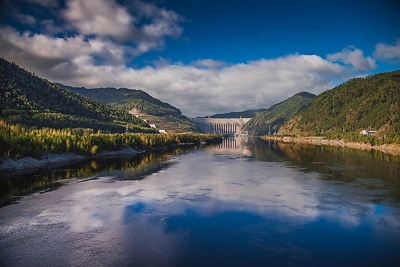
The upper reaches, subject to rapids and flooding, pass through sparsely populated areas. The middle section is controlled by a series of massive hydroelectric dams fuelling significant Russian primary industry. Partly built by gulag labor in Soviet times, industrial contamination remains a serious problem in an area hard to police. Moving on through sparsely-populated taiga, the Yenisei swells with numerous tributaries and finally reaches the Kara Sea in desolate tundra where it is icebound for more than half the year. As with other Siberian rivers, the flow has increased recently, believed to be related to global warming. A concern is that altered salinity in the Arctic may have a global impact on ocean currents.

The peoples of the Yenisey valley are diverse. Around the western headwaters (Great and Little Yenisey), Tyvans (Tuvans) predominate in the rural areas, but they are joined by significant numbers of Russians in Kyzyl, the capital of Tyva. To the north of Tyva the Krasnoyarsk kray (territory) of Russia extends down the entire valley northward to the Kara Sea; its population comprises Russians, Ukrainians, Tatars, and numerous other indigenous peoples. The Khakass people occupy Khakassia southwest of Krasnoyarsk. The vast Evenk autonomous okrug (district), extending from south of the Stony Tunguska to north of the Kureyka, is inhabited both by the Evenk people and by Russians from the west and Sakha (Yakut) from the east. In the far north, the Taymyr autonomous okrug has a majority of Russians and some Evenk but also the Sakha, Dolgan, Nenets, and Nganasan peoples.

Picture Credit : Google

Which is the longest river in Asia and runs through nine of China's provinces?

The Yangtze River in China is the longest river in Asia, the third longest river in the world and the longest river to flow entirely in one country. The river begins its journey in the glacial meltwaters of the Tanggula Mountains in Tibet and flows approximately 3,915 miles (6,300 kilometers) until it empties in the East China Sea near the city of Shanghai. The river flows through or borders 10 provinces. 

Yangtze, which means "child of the ocean," is a name primarily used by Westerners. In China, the river is referred to as Chang Jiang, meaning "long river," while the name Yangtze is reserved for the small section of the river near its mouth. 

The river flows through a variety of terrains, including high plateaus and lowland plains, but most of its journey — approximately three-fourths of it — is spent passing through mountainous regions, including some extremely scenic areas with deep valleys, canyons and gorges. The river is fed by approximately 700 tributaries, including eight principal rivers: Yalung, Min, Jialing, Han, Wu, Yuan, Xiang and Gan rivers, according to the Encyclopaedia Britannica.

The Yangtze plays a central role in Chinese agriculture, industry and travel. It is the country's primary waterway, and nearly one-third of the population lives in its basin — an area covering about 448 million acres — according to the World Wildlife Fund (WWF). Traditionally, the Yangtze River has been considered a dividing line between North and South China, although geographers consider the true line to be the Qinling-Huai River, according to the New World Encyclopedia.

Credit : Britannica 

Picture Credit : Google

Which river flows through 10 U.S. States?

Mississippi River, the longest river of North America, draining with its major tributaries an area of approximately 1.2 million square miles (3.1 million square km), or about one-eighth of the entire continent. The Mississippi River lies entirely within the United States. Rising in Lake Itasca in Minnesota, it flows almost due south across the continental interior, collecting the waters of its major tributaries, the Missouri River (to the west) and the Ohio River (to the east), approximately halfway along its journey to the Gulf of Mexico through a vast delta southeast of New Orleans, a total distance of 2,340 miles (3,766 km) from its source. With its tributaries, the Mississippi drains all or part of 31 U.S. states and two provinces in Canada.

Although the Mississippi can be ranked as the fourth longest river in the world by adding the length of the Missouri-Jefferson (Red Rock) system to the Mississippi downstream of the Missouri-Mississippi confluence—for a combined length of 3,710 miles (5,971 km)—the 2,340-mile length of the Mississippi proper is comfortably exceeded by 19 other rivers. In volume of discharge, however, the Mississippi’s rate of roughly 600,000 cubic feet (17,000 cubic metres) per second is the largest in North America and the eighth greatest in the world.

As the central river artery of a highly industrialized nation, the Mississippi River has become one of the busiest commercial waterways in the world, and, as the unruly neighbour of some of the continent’s richest farmland, it has been subjected to a remarkable degree of human control and modification. Furthermore, the river’s unique contribution to the history and literature of the United States has woven it like a bright thread through the folklore and national consciousness of North America, linking the names of two U.S. presidents—Abraham Lincoln and Ulysses S. Grant—with that of the celebrated author Mark Twain.

Credit : Britannica 

Picture Credit : Google

Which is the second longest river in the world?

Amazon River of South America is the second longest river in the world with a length of 6,400 km. But it is by far the largest river by water flow with an average discharge greater than the next seven largest rivers combined. It flows through Brazil, Peru, Bolivia, Colombia, Ecuador, Venezuela and Guyana.

 Its westernmost source is high in the Andes Mountains, within 100 miles (160 km) of the Pacific Ocean, and its mouth is in the Atlantic Ocean, on the northeastern coast of Brazil. However, both the length of the Amazon and its ultimate source have been subjects of debate since the mid-20th century, and there are those who claim that the Amazon is actually longer than the Nile. 

The first European to explore the Amazon, in 1541, was the Spanish soldier Francisco de Orellana, who gave the river its name after reporting pitched battles with tribes of female warriors, whom he likened to the Amazons of Greek mythology. Although the name Amazon is conventionally employed for the entire river, in Peruvian and Brazilian nomenclature it properly is applied only to sections of it. In Peru the upper main stream (fed by numerous tributaries flowing from sources in the Andes) down to the confluence with the Ucayali River is called Maranon, and from there to the Brazilian border it is called Amazonas. In Brazil the name of the river that flows from Peru to its confluence with the Negro River is Solimoes; from the Negro out to the Atlantic the river is called Amazonas.

Credit : Britannica 

Picture Credit : Google

Which is the longest river in the world stretching from East Africa to the Mediterranean?

The Nile River flows from south to north through eastern Africa. It begins in the rivers that flow into Lake Victoria (located in modern-day Uganda, Tanzania, and Kenya), and empties into the Mediterranean Sea more than 6,600 kilometers (4,100 miles) to the north, making it one of the longest river in the world. The Nile River was critical to the development of ancient Egypt. In addition to Egypt, the Nile runs through or along the border of 10 other African countries, namely, Burundi, Tanzania, Rwanda, the Democratic Republic of the Congo, Kenya, Uganda, Sudan, Ethiopia, and South Sudan. Its three main tributaries are the White Nile, the Blue Nile, and the Atbara.

The soil of the Nile River delta between El Qahira (Cairo) and the Mediterranean Sea is rich in nutrients, due to the large silt deposits the Nile leaves behind as it flows into the sea. The banks of the Nile all along its vast length contain rich soil as well, thanks to annual flooding that deposits silt. From space, the contrast between the Nile's lush green river banks and the barren desert through which it flows is obvious.

For millennia, much of Egypt's food has been cultivated in the Nile delta region. Ancient Egyptians developed irrigation methods to increase the amount of land they could use for crops and support a thriving population. Beans, cotton, wheat, and flax were important and abundant crops that could be easily stored and traded. 

The Nile River delta was also an ideal growing location for the papyrus plant. Ancient Egyptians used the papyrus plant in many ways, such as making cloth, boxes, and rope, but by far its most important use was in making paper. Besides using the river's natural resources for themselves and trading them with others, early Egyptians also used the river for bathing, drinking, recreation, and transportation.

Today, 95 percent of Egyptians live within a few kilometers of the Nile. Canals bring water from the Nile to irrigate farms and support cities. The Nile supports agriculture and fishing. The Nile also has served as an important transportation route for thousands of years. Today, some residents of El Qahira (Cairo) have begun using private speed boats, water taxis, or ferries to avoid crowded streets. Dams, such as the Aswan High Dam in Egypt, have been built to help to tame the river and provide a source of hydroelectric power.

However, the silt and sediment that used to flow north, enriching the soil and building the delta, is now building up behind the dam instead. Instead of growing in size through the soil deposits, the delta is now shrinking due to erosion along the Mediterranean Sea. In addition, routine annual flooding no longer occurs along parts of the Nile. These floods were necessary to flush and clean the water of human and agricultural waste. As a result, the water is becoming more polluted.

Credit : National Geographic Society 

Picture Credit : Google