These 200,000-Year-Old Hand and Footprints Could Be the World’s Earliest Cave Art

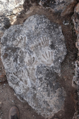
Between 1,69,000 and 2,26,000 years ago, two children in what is now Quesang, Tibet, left a set of handprints and footprints on a boulder. Seemingly placed intentionally, the now-fossilised impressions may be the world's oldest known parietal or cave art a new study published online on September 10, 2021 in the journal Science Bulletin suggested.

Researchers used uranium, a naturally found radioactive element, to date the prints. They estimated that the impressions were left in the Pleistocene epoch – which occurred 2.6 million to 11,700 years ago. The marks were likely left by two children, one the size of a modern-day 12-year-old and the other the size of a 7-year-old. 

Still, the team couldn’t tell what species of archaic humans actually left the prints. Study co-author Matthew Bennett told Live Science that “Denisovans are a real possibility,” but also mentioned that Homo erectus was also known to inhabit the region. He said “there are lots of contenders” but that they don’t know at this point. 

As the researchers explain in an article, hand shapes can be commonly found in prehistoric caves. The hand is usually used as a stencil, spreading pigment around the edge. The oldest known examples are the caves in El Castillo, Spain, and Sulawesi, Indonesia. Now, whether this is art or not, that’s a big debate.

Credit : ZME Science 

Picture Credit : Google

World’s Largest Handmade Drawings Discovered in Thar

In a paper published online in Archaeological Research in Asia on May 12, 2021 by researchers Carlo Oetheimer and Yohann Oetheimer, they said the geoglyphs found near Boha village, in Rajasthan's Thar Desert-spread over 51 acres are the largest discovered worldwide and the first in the Indian subcontinent. They are unique as regards their enigmatic signs. The researchers first discovered the lines on Google Earth in 2014 while conducting a virtual survey of the region.

The researchers say that these geoglyphs are the largest ones discovered worldwide, and the first of their kind in the Indian subcontinent. The largest figure was named Boha 1, and is a giant asymmetrical spiral made from a single line that loops and runs for around 12 kilometres. “The Boha 1 unit interpreted as a series of 12 eccentric ellipses, was revealed to be a huge spiral,” the paper reads.

Boha 2 is a serpentine figure, around 11 km long. “By analogy these curves replicate a boustrophedon. This term refers to primitive writings whose lines can be read from left to right and then from right to left, in the same way a plow travels in a field. The inflection points in the lines generate a gap of 4.7–14 m between them,” reads the paper.

Boha 3 and 4 included a series of meandering lines, and “two iconographic units, adjacent to the previous ones, draw about 80 serpentine lines between 40 and 200 m long. Boha 3 forms a cluster of lines oriented towards the NE, immediately at the apex of the giant spiral. Boha 4, on the other hand, is located about 50 meters away, SW of the boustrophedon. We experienced more difficulty achieving a precise mapping because many of these lines are heavily eroded. They have generally random sinuosities and adopt rhythmic undulations that look like braids in two areas”.

Credit : The Better India

Picture Credit : Google

Stone slab found in France thought to be Europe’s oldest 3D map

According to media reports in April 2021, a Bronze-Age stone unearthed in France was confirmed to be the oldest three-dimensional map in Europe. The five-ft-by-6.5-ft slab, first uncovered in 1900 and forgotten, was found again in a cellar in a castle in 2014. Archaeologists who studied patterns engraved on the 4,000-year-old stone said they believe the markings were the map of an area in western Brittany.

After analysing marks and engravings on the stone, the researchers suspected it could be a map.

The "presence of repeated motifs joined by lines" on its surface suggested it depicted an area of Finistere, a study in the Bulletin of the French Prehistoric Society said.

The researchers say the indentations are a 3D representation of the River Odet valley, while several lines appear to depict the area's river network.

Geo-location revealed the territory represented on the slab bears an 80% accuracy to an area around an 18 mile-long stretch of the river.

"This is probably the oldest map of a territory that has been identified," Dr Clement Nicolas from Bournemouth University, one of the study's authors, told the BBC.

"There are several such maps carved in stone all over the world. Generally, they are just interpretations. But this is the first time a map has depicted an area on a specific scale."

Dr Nicolas said the map may have been used to mark a particular area.

"It was probably a way to affirm the ownership of the territory by a small prince or king at the time," he said.

"We tend to underestimate the geographical knowledge of past societies. This slab is important as it highlights this cartographical knowledge."

Credit : BBC

Picture Credit : Google

3,000-year-old ‘lost golden city’ of ancient Egypt discovered

On April 8, 2021, famed Egyptologist Zahi Hawass announced the discovery of the "lost golden city" near Luxor, Egypt. He said the find was the largest ancient city, known as Aten, ever uncovered in Egypt. It was unearthed within weeks of the excavation starting in September 2020. The city dates to the reign of Amenhotep III, one of Egypt's most powerful pharaohs, who ruled from 1391 to 1353 BC. The city continued to be used by pharaohs Ay and Tutankhamun, whose nearly intact tomb was discovered in the Valley of the Kings by British archaeologist Howard Carter in 1922.

After seven months of excavations, several neighbourhoods have been uncovered, including a bakery complete with ovens and storage pottery, as well as administrative and residential districts.

Amenhotep III inherited an empire that stretched from the Euphrates to Sudan, archaeologists say, and died around 1354 BC.

He ruled for nearly four decades, a reign known for its opulence and the grandeur of its monuments, including the Colossi of Memnon – two massive stone statues near Luxor that represent him and his wife.

“The archaeological layers have laid untouched for thousands of years, left by the ancient residents as if it were yesterday,” the team’s statement said.

Bryan said the city “will give us a rare glimpse into the life of the Ancient Egyptians at the time where the empire was at his wealthiest”.

The team said it was optimistic that further important finds would be revealed, noting it had discovered groups of tombs it reached through “stairs carved into the rock”, a similar construction to those found in the Valley of the Kings.

“The mission expects to uncover untouched tombs filled with treasures,” the statement added.

After years of political instability linked to a popular revolt in 2011, which dealt a severe blow to Egypt’s key tourism sector, the country is seeking to bring back visitors, in particular by promoting its ancient heritage.

Last week, Egypt transported the mummified remains of 18 ancient kings and four queens across Cairo from the Egyptian Museum to the new National Museum of Egyptian Civilisation, a procession dubbed the “Pharaohs’ Golden Parade”.

Among the 22 bodies were those of Amenhotep III and his wife Queen Tiye.

Credit : The Guardian 

Picture Credit : Google