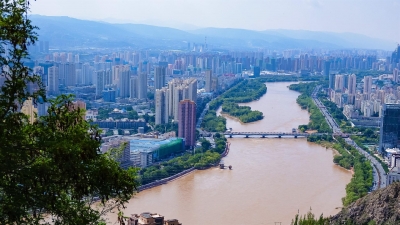
Why is the Ganga said to be the longest river in India?

As per the overall distance covered by a river within the country, the Ganga is the longest river in India. Even though Brahmaputra and Indus are longer than the Ganga in total length, distances these two major rivers of the Indian subcontinent cover within the country is shorter than that of the Ganga.

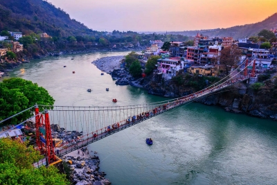
Originating from the Gangotri and Yamunotri glaciers in Uttarakhand, the Bhagirathi and Alaknanda rivers meet at Devprayag to form the Ganga. Ganga covers the states of Uttarakhand, Uttar Pradesh, Bihar, West Bengal and then enters Bangladesh. Rishikesh, Varanasi, Kanpur, Prayagraj, Haridwar, Patna, and Bhagalpur are some of the major cities along the banks of this river. Son, Yamuna, Gomti, Koshi, Ghaghara, and Gandak are some of its major tributaries. It covers 2,525 kilometres before merging with the Bay of Bengal.

Picture Credit : Google 

Which is the deepest lake?

The world's deepest freshwater lake is Lake Baikal located in Siberia. It holds more than 20 per cent of the unfrozen fresh water on the surface of the Earth and is the oldest freshwater lake in the world - it is estimated that the lake has been here for about 20 million to 25 million years. This magnificent natural water body is known as the 'Galapagos of Russia.' Its age and isolation have led to the existence of some of the most unusual and exceptional freshwater fauna of the world, making it a hotspot for evolutionary science.

Baikal is home to a great variety of animal and plant species that cannot be found anywhere else on the planet. Of the rare species here, the Baikal seal (also called the nerpa) is the only species of seal in the world to exist in a freshwater habitat. Since the lake lies hundreds of kilometres inland, it remains a mystery as to how the ancestors of these seals arrived in Lake Baikal. More than 330 rivers and streams enter Lake Baikal- the largest of which include the Selenga, Barguzin, Upper Angara, Chikoy, and Uda. There are a number of industries along the shores of Baikal. Mining (mica and marble), cellulose and paper manufacturing, ship building, fisheries, and timber are some of the prominent ones.

Picture Credit :Google

Where is Lake Titicaca, the highest navigable lake located?

Lake Titicaca is located at 3,810 metres above sea level in the Andes Mountains of South America along the border of Peru and Bolivia to the west and the east, respectively. It is the world's highest lake navigable by large vessels. By volume of water, Lake Titicaca is the largest lake of South America.

Over 25 rivers end up in Titicaca, of which the largest is the Ramis River, which occupies about two-fifths of the entire Titicaca Basin. It enters the north-western corner of the lake. Another small river, the Desaguadero, merges with the lake at its southern end.

Before the arrival of the Incas many other cultures lived on the lake. A team of international archaeologists and divers excavated the ruins of an underwater temple in the year 2000. It is thought to be between 1,000 and 1,500 years old, most likely built by the Tiwanaku people. The ruins have been measured to be 200 by 50 metres. There was a village along with the temple and it had some roads, terraces for farming and a retaining wall, which was 800 metres.

Although the meaning of the name Titicaca is uncertain, it has been translated as Rock of the Puma or Crag of Lead.

Picture Credit : Google

Why is the title of the longest river a matter of controversy?

There is a centuries old dispute about which river is the longest. The contestants for this title are the Amazon River and the Nile River, and they both have strong claims on their sides. According to the Guinness Book of World Records, Nile is officially the longest river. Its main source is Lake Victoria in east central Africa and it flows over 6600 kilometres to merge into the Mediterranean Sea. The Nile River is a source of water for the following eleven countries: Burundi, the Democratic Republic of the Congo, Kenya, Tanzania, Uganda, Rwanda, Ethiopia, Eritrea, South Sudan, Sudan and Egypt.

Until 1971, the true source of the Amazon River was not discovered. In the same year, Loren McIntyre, an American photojournalist who worked extensively in South America, claimed that this river originated in the snow-covered Andes of southern Peru. This makes the Amazon River's length 6700 kilometres when it flows into the South Atlantic Ocean through the Par estuary (which is its most distant mouth). But here again, the calculations are not that simple as the Amazon has several mouths, making it extremely difficult to ascertain the exact point where the river ends.

Picture Credit : Google 

Which is the longest constructed waterway?

The longest waterway that has ever been constructed is located in China, and connects Hang-zhou in Zhejiang province with Beijing. The Grand Canal, also called Jing-Hang Yunhe, is not a single waterway but a series of waterways with length of around 1776 km. Successive Chinese regimes used this waterway to transport surplus grains from the agriculturally rich Yangtze (Chang) and Huai river valleys to feed the capital cities and the large armies in northern China. This structure is now considered as a UNESCO World Heritage site.

The part of the canal that was originally on the Huang He (Yellow River) is the oldest part of this waterway. It was traditionally known as the Shanyang Canal but it is now called the Southern Grand Canal (Nan Yunhe) and is located between the Yangtze and the city of Huaiyin (formerly called Qingjiang) in Jiangsu province. It reaches its maximum height of 42 metres in the mountains of Shan-dong.

This system of canals has led to faster trading between different provinces and has supported China’s economy. The part of the canal in the south of the Yellow River continues to be extensively used by barges carrying bulk materials and containers.

Picture Credit : Google