What is Stalactite?


These hang down like icicles. They form in the same way as stalagmites, from rocky particles dissolved in water, this time dripping from the caves ceiling.


A drop on the tip of a growing stalactite leaves a deposit only around its rim. Downward growth of the rim makes the tube. The simplest stalactite form, therefore, is a thin-walled stone straw, and these fragile forms may reach lengths of 0.5 m (20 inches) or more where air currents have not seriously disturbed the growth. The more common form is a downward-tapering cone and is simply a thickening of the straw type by mineral deposition from a film of water descending the exterior of the pendant.


Picture Credit : Google


What is Stalagmite?


Water dripping onto the cave floor leaves behind tiny rocky particles that were dissolved in it. As the dripping continues, these particles can build up form a pillar of rock, or stalagmite.


Stalagmites have thicker proportions and grow up on the bottom of a cavern from the same drip-water source, the mineral from which is deposited after the water droplet falls across the open space in the rock. Not every stalactite has a complementary stalagmite, and many of the latter may have no stalactite above them. Where the paired relation exists, however, continual elongation of one or both may eventually result in a junction and the formation of a column.


Picture Credit : Google


What are Caves? What are the types of cave?


Caves are underground spaces or hole that are large enough for someone to enter. They form in many different ways, but mostly because of rock in the Earth’s surface being worn away or crumbling. Caves usually have lots of interesting and exciting features to explore.


There are many types of caves formed through different processes: some are small, and it is difficult for man to penetrate into; others, on the contrary, stretch underground for tens or hundreds of kilometres, reaching depths of over 2,000 m. Formation processes control length, development and shape of a cave, and also the difficulties that will arise when exploring them. Most of the longest and deepest caves do not consist in an isolated cavity, but they form a system, which at times may be very complex, made of rooms, sinkholes, shafts, meanders, canyons, interconnecting galleries, which are arranged to form a system or karst complex.

Large quantities of underground water move through karst systems, caves may therefore be classified in different sub-areas, i.e. occupied by air and completely dry or scoured by streams, they may be flooded at times, or permanently invaded by fresh and salt water.


Caves are found all over our planet. Some are small, single spaces, but others contain many chambers, linked by tunnels to form a huge maze of different areas. Although most caves are found in rock, some form in ice or lava.


Solutional caves


These are the most common type of cave. They are created when a build up acidic water dissolves the rock around it. Holes and tunnels start to appear, getting bigger and bigger as more rock dissolves and is washed away.


Solution caves are formed when groundwater seeps underground via cracks, faults, joints, bedding places, and other surface openings. Over geological epochs, small cracks in the rock become large cave systems. Limestone solution caves are very picturesque as they are often adorned with cave formations like stalactites and stalagmites formed by calcium carbonate precipitation. Such caves are formed by the dissolution of limestone by acidic water (water with dissolved carbonic acid).


Lava caves


When lava flows slowly over land around a volcano, it can harden on the surface, leaving liquid lava flowing underneath. This liquid drains away, leaving a hollow tube of rock that forms a cave.


When hot liquid lava flows down the slope of a volcano, the surface of the lava cools and solidifies. However, hot liquid lava continues to flow beneath the solidified surface and when the flow stops, a hollow tube remains. Such types of caves are called lava tubes. Lava mold caves, rift caves, inflationary caves, and volcanic conduits are other caves formed by volcanic activity. The Kazumura Cave in Hawaii is an example of a 65.8 km long lava tube.


Ice caves


Ice melting on top of a glacier can form a stream or waterfall that flows through the glacier. Eventually, this flowing water will hollow out part of the glacier, creating an ice cave.


The second type of ice cave occurs either when frigid winter air settles into downward-leading caverns where it cannot be forced out or when moisture freezes in currents of cold air. Frozen lakes, icicles, and ice draperies are common formations. Helictite-like icicles also form where air currents deflect the freezing water. The splendid ice deposits formed in the lava caves of the northwestern United States are dwarfed by the limestone ice-cave systems of the Alps.


Sea Caves


These are formed by waves constantly battering against cliffs along the seashore. This leads to cracks appearing in the cliffs that get larger as beating waves continue to wear away the rock.


Sea caves are often a major tourist attraction. Some sea caves can be accessed only by boats during low tide while others are more easily accessible and occur along beaches where it is possible to walk into the caves. Cathedral Cove Sea Cave, in Coromandel, New Zealand is an example of a sea cave.


Picture Credit : Google


What is the source of river?


This is where a river starts, high up in the mountains. The source, or place where the river starts from, could be a springs or a lake, or even a melting glacier. A river can have more than one source.


The source is the farthest point of the river stream from its estuary or its confluence with another river or stream. Rivers are usually fed by many tributaries. The farthest stream is called the head-stream or head water. There is sometimes disagreement on which source is the head water, hence on which is the true source. Headwaters are usually in mountains. Glacial headwaters are made by melting glaciers.


The source is where a river begins, and the mouth is where it joins the sea. The source of a river generally discharges water with less force leading to the formation of Interlocking spurs.


The river mouth is the opposite of a river source. The mouth is where the river ends as it meets the ocean, and may have a river delta.


Picture Credit : Google


What are Rivers?


A river is a natural channel of fresh water that flows across the Earth’s surface. All rivers start in mountains or hills and flow down towards the sea or ocean, or into another large area of water. They may be short or flow for hundreds of kilometres.


Rivers are part of the hydrological cycle; water generally collects in a river from precipitation through a drainage basin from surface runoff and other sources such as groundwater recharge, springs, and the release of stored water in natural ice and snowpacks (e.g., from glaciers). Potamology is the scientific study of rivers, while limnology is the study of inland waters in general. Most of the major cities of the world are situated on the banks of rivers, as they are, or were, used as a source of water, for obtaining food, for transport, as borders, as a defensive measure, as a source of hydropower to drive machinery, for bathing, and as a means of disposing of waste.


Picture Credit : Google


What is weathering? What are the types of weathering?


Weathering occurs when rocks are weakened, so that they crack and then break up into smaller pieces. This natural process can be caused by rainfall, changes in temperature or even by plants as they grow. Weathering and erosion constantly change the rocky landscape of Earth. Weathering wears away exposed surfaces over time. The length of exposure often contributes to how vulnerable a rock is to weathering. Rocks, such as lavas, that are quickly buried beneath other rocks are less vulnerable to weathering and erosion than rocks that are exposed to agents such as wind and water.


As it smoothes rough, sharp rock surfaces, weathering is often the first step in the production of soils. Tiny bits of weathered minerals mix with plants, animal remains, fungi, bacteria, and other organisms. A single type of weathered rock often produces infertile soil, while weathered materials from a collection of rocks is richer in mineral diversity and contributes to more fertile soil. Soils types associated with a mixture of weathered rock include glacial till, loess, and alluvial sediments.


Biological Weathering:


This is when plants or animals cause rocks to break up. Plant rocks to break up. Plant roots often grow into small cracks in rocks, splitting them apart. An animal digging can also turn rocks into rubble.


Microscopic organisms like algae, moss, lichens and bacteria can grow on the surface of the rocks and produce chemicals that have the potential of breaking down the outer layer of the rock. They eat away the surface of the rocks. These microscopic organisms also bring about moist chemical micro-environments which encourage the chemical and physical breakdown of the rock surfaces. The amount of biological activity depends upon how much life is in that area. Burrowing animals such as moles, squirrels and rabbits can speed up the development of fissures.


Chemical Weathering: 


Chemical reactions can break up rock. Acid rain, for example, destroys the stone in statues and buildings.


The natural chemical reactions within the rocks change the composition of the rocks over time. Because the chemical processes are gradual and ongoing, the mineralogy of rocks changes over time thus making them wear away, dissolve, and disintegrate.


The chemical transformations occur when water and oxygen interacts with minerals within the rocks to create different chemical reactions and compounds through processes such as hydrolysis and oxidation. As a result, in the process of new material formations, pores and fissures are created in the rocks thus enhancing the disintegration forces.


Physical or Mechanical Weathering: 


Wind water and temperature changes weaken rock. If water in a crack freezes, it expands and can tear a rock apart. One of the most common mechanical actions is frost shattering. It happens when water enters the pores and cracks of rocks, then freezes. Frost weathering, frost wedging, ice wedging or cryofracturing is the collective name for several processes where ice is present. These processes include frost shattering, frost-wedging and freeze-thaw weathering.


Another type of mechanical weathering is called salt wedging. Winds, water waves, and rain also have an effect on rocks as they are physical forces that wear away rock particles, particularly over long periods of time. These forces are equally categorized under mechanical or physical weathering because they release their pressures on the rocks directly and indirectly which causes the rocks to fracture and disintegrate.


Picture Credit : Google


What is erosion? What are the agents of erosion?


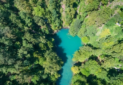
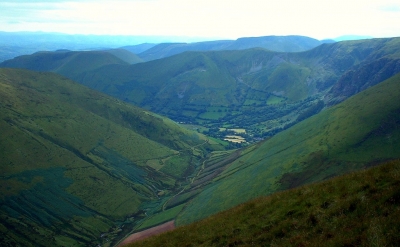
Erosion is the wearing away of rocks and other matter on the Earth’s surface by a natural force, such as a sliding glaciers, a flowing river, or the wind. Material that is rubbed off is carried away and deposited somewhere else.


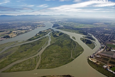
Most erosion is performed by liquid water, wind, or ice (usually in the form of a glacier). If the wind is dusty, or water or glacial ice is muddy, erosion is taking place. The brown color indicates that bits of rock and soil are suspended in the fluid (air or water) and being transported from one place to another. This transported material is called sediment.


Water erosion


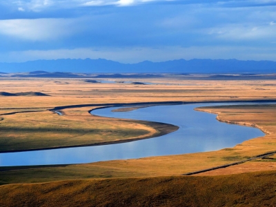
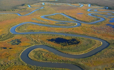
This is caused by falling rain or flowing water. Rivers, for example, wear away the land that they flow over, changing the surrounding landscape. Raindrops hit bare soil with enough force to break the soil aggregates. These fragments wash into soil pores and prevent water from infiltrating the soil. Water then accumulates on the surface and increases runoff which takes soil with it.


Well-structured soils are less prone to break up, and the impact of raindrops is minimized if the soil surface is protected by plant or litter cover. 


Wind erosion


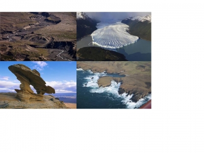
The force of the wind can remove pieces of rock and carry them off. Wind erosion is common in deserts. Wind erosion is a serious environmental problem attracting the attention of many across the globe. It is a common phenomenon occurring mostly in flat, bare areas; dry, sandy soils; or anywhere the soil is loose, dry, and finely granulated. Wind erosion damages land and natural vegetation by removing soil from one place and depositing it in another. It causes soil loss, dryness and deterioration of soil structure, nutrient and productivity losses and air pollution. Suspended dust and dirt is inevitably deposited over everything. It blows on and inside homes, covers roads and highways, and smothers crops. Sediment transport and deposition are significant factors in the geological changes which occur on the land around us and over long periods of time are important in the soil formation process.
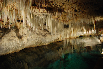
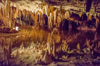
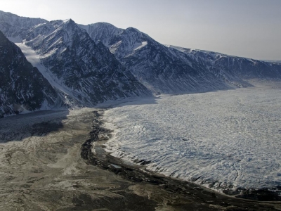
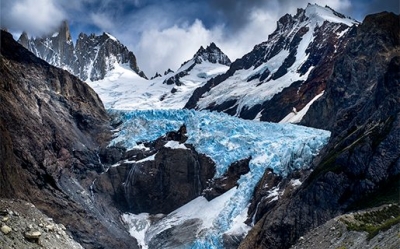


Ice erosion


As glaciers move, they rub away the land under them, carrying the broken-down material with them. Ice erosion occurs in one of two forms, the movement of glaciers, or thawing processes. In the latter formation, water inside pores and rock fractures expand, which causes further cracking. Glaciers erode through one of three different processes, including abrasion, plucking, and thrusting. Debris caught in the basal brushes along the bed, which polishes and gouges the rocks underneath. Glaciers also cause bedrock to fall off during the plucking phase. In addition, glaciers freeze and then move forward, which dislodges the sediments at the glacier’s base. The latter method produces thousands of lake basins that lie across the edge of the Canadian Shield. All of these combined processes form moraines, drumlins, kames, moulins, and glacial erratics, especially at the glacier retreat.


Extreme cold weather temperatures cause trapped water particles to expand in its cracks, which breaks the rock into several pieces. This senior care leads to gravity erosion, particularly on steep slopes, and the formation of scree at the bottom of a mountainside. Morning thaws can present structural problems for roads alongside mountain cliffs. Additionally, trapped water in the wedge of a rock causes fissures, which eventually breaks down the rock.
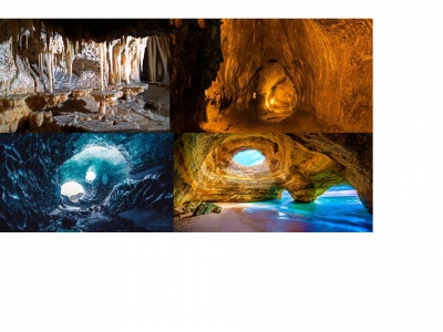


Coastal erosion


Crashing waves gradually wear away the rock in cliffs, and sweep up material from the beach. Coastal erosion is typically driven by the action of waves and currents, but also by mass wasting processes on slopes, and subsidence (particularly on muddy coasts). Significant episodes of coastal erosion are often associated with extreme weather events (coastal storms, surge and flooding) but also from tsunami, both because the waves and currents tend to have greater intensity and because the associated storm surge or tsunami inundation can allow waves and currents to attack landforms which are normally out of their reach. On coastal headlands, such processes can lead to undercutting of cliffs and steep slopes and contribute to mass wasting. In addition, heavy rainfall can enhance the saturation of soils, with high saturation leading to a reduction in the soil's shear strength, and a corresponding increase in the chance of slope failure (landslides).


Coastal erosion is a natural process which occurs whenever the transport of material away from the shoreline is not balanced by new material being deposited onto the shoreline. Many coastal landforms naturally undergo quasi-periodic cycles of erosion and accretion on time-scales of days to years. This is especially evident on sandy landforms such as beaches, dunes, and intermittently closed and open lagoon entrances. However, human activities can also strongly influence the propensity of landforms to erode.


Picture Credit : Google


What is Glacier terminus?


The glacier terminus is the lower end of a glacier. it is sometimes called the toe or snout. Some glaciers end further down a mountain, where the ice melts to form lakes and streams. Others reach the coast, where large chunks break off into the sea, creating icebergs. This is called calving.


Tracking the change in location of a glacier terminus is a method of monitoring a glacier's movement. The end of the glacier terminus is measured from a fixed position in neighboring bedrock periodically over time. The difference in location of a glacier terminus as measured from this fixed position at different time intervals provides a record of the glacier's change. A similar way of tracking glacier change is comparing photographs of the glacier's position at different times.


The form of a glacier terminus is determined by many factors. If the glacier is retreating, it is usually mildly sloping in form because a melting glacier tends to assume this shape. But there are many conditions that alter this typical shape, including the presence of thermal fields and various stresses that cause cracking and melting feedback resulting in glacial calving and other diverse forms.


Picture Credit : Google


What are the parts of a Glacier?


Cirques 


Cirques are deep hollows near the top of a glacier, formed where a glacier has moved over an area and worn away the rock. The glacial cirque is opened on the downhill side while the cupped section is steep. The cliffs on the sides slope down and combine and converge from three or more higher sides. The floor of the cirque is bowl-shaped because of the convergence zones of combining ice flows from a different direction and the debris accompanying them. A Cirque experiences greater erosion because of the accompanying rock burdens which may also over deepen the level of a cirque. Cirques subjected to seasonal melting often form small lakes called tarns behind the Moraine.


Accumulation zones 


Accumulation Zones are found at the top of glaciers, where the snowfall has built up, often over hundreds of years. Glaciologists subdivide glaciers into glacier accumulation zones, based on the melting and refreezing occurring. These zones include the dry snow zone, in which the ice entirely retains subfreezing temperatures and no melting occurs. Dry snow zones only occur within the interior regions of the Greenland and Antarctica ice sheets. Below the dry snow zone is the percolation zone, where some melt water penetrates down into the glacier where it refreezes. In the wet snow zone, all the seasonal snow melts. The melt water either percolates into the depths of the glacier or flows down-glacier where it might refreeze as superimposed ice. A glacier's equilibrium line is located at the lower limit of the wet snow zone.


Valley glaciers 


Valley glaciers flow through steep-walled valleys. They eventually wear down the valley sides, making them much rounder. Valley glaciers that flow far enough to reach the sea are called tidewater glaciers. Such glaciers are often the source of numerous small icebergs that might pose a problem to navigating vehicles. Often fjords are formed at the edges of such glaciers when the glaciers retreat and sea water fills the void. A hanging glacier is a part of a valley glacier system. Such glaciers originate high on a glacial valley's walls and descend to a certain extent along the valley before making an abrupt stop, usually at a cliff. Such glaciers are called hanging glaciers and ice fall and avalanches originating at such glaciers are responsible for snow and ice on the valley floor lying below. When such hanging glaciers retreat, hanging valleys are formed. The Mer de Glace glacier on the Mont Blanc massif's northern slopes is a valley glacier in the French Alps.


Lateral moraines 


Lateral moraines are long ridges of rock, soil, and dirt left along the sides of a moving glacier. They form only in the ablation zone of a glacier (where more ice is melting than is accumulating as snow each year). This makes them good indicators of where the line between the accumulation zone and the ablation zone—the equilibrium line—occurred on past glaciers. They often remain on the landscape long after glacier retreat and are frequently contiguous with terminal moraines.


Medical moraines 


A medial moraine is found on top of and inside an existing glacier. Medial moraines are formed when two glaciers meet. Two lateral moraines from the different glaciers are pushed together. This material forms one line of rocks and dirt in the middle of the new, bigger glacier. 


If a glacier melts, the medial moraine it leaves behind will be a long ridge of earth in the middle of a valley.


What are Glaciers?


A glacier is a huge river of ice that forms when thick layers of snow fall on top of each other and are pressed together. Most glaciers form high up in mountains, where it’s so cold that any snowfall never melts. They are found all around the world, usually in polar and mountainous regions.


Most of the world's glacial ice is found in Antarctica and Greenland, but glaciers are found on nearly every continent, even Africa. Because certain climatic and geographic conditions must be present for glaciers to exist, they are most commonly found above snow line: regions of high snowfall in winter and cool temperatures in summer. This condition allows more snow to accumulate on the glacier in the winter than will melt from it in the summer. This is why most glaciers are found either in mountainous areas or the Polar Regions. However, snow line occurs at different altitudes: in Washington State the snow line is around 1,600 meters (5,500 feet), while in Africa it is over 5,100 meters (16,732 feet), and in Antarctica it is at sea level. The amount of snowfall a glacier receives is very important to its survival, which is why some cold regions, like Siberia, have almost no glaciation—there is not enough snowfall.


Picture Credit : Google


What is Estuary or delta?


Near the sea, salt water mixes with fresh water, forming an estuary. The land is flatter, so the river slows down. If it slows down enough, mud is deposited, creating a delta with several channels that the river now flows through.


The basic difference between estuary and delta is that the former is a tidal mouth of the river, where it meets the sea, whereas the latter is nothing but the wetland, formed as a result of the accumulation of sediments carried by the river when it joins a standing water body.


While an estuary is a semi-enclosed body of water, where river meets the ocean, the delta is a low-lying plain, formed by the accumulation of alluvium. There is four major types of estuaries which are drowned river valley estuary, bar-built estuary, fjord estuary and tectonic estuary. On the contrary, various types of delta include wave-dominated delta, tide-dominated delta, Gilbert delta, tidal-freshwater delta, inland delta and mega-delta.


Picture Credit : Google


What are fertile Floodplains?


These are flat areas of land next to a river. Water in river may increase for some reason and become too much for the river to carry. It then overflows onto the floodplain. Soil in floodplains is usually very fertile.


A flood plain consists of two parts. The first is the main channel of the river itself, called the floodway. Floodways can sometimes be seasonal, meaning the channel is dry for part of the year. 


Beyond the floodway is the flood fringe. The flood fringe extends from the outer banks of the floodway to the bluff lines of a river valley. Bluff lines, also called valley walls, mark the area where the valley floor begins to rise into bluffs.


Some rivers have very narrow flood plains. In fact, some rivers, or parts of rivers, seem to have no flood plain at all. These rivers usually have a steep stream gradient—a very deep, fast-moving channel. 


Picture Credit : Google


What is Meander?


A meander is a curve or bend in a river. It forms when the flow of water wears away the land on one side of the river, then dumps the broken-down rocks this creates on the other side, increasing the area of land there.


A meander is produced by a stream or river as it erodes the sediments comprising an outer, concave bank (cut bank) and deposits this and other sediment downstream on an inner, convex bank which is typically a point bar. The result of sediments being eroded from the outside concave bank and their deposition on an inside convex bank is the formation of a sinuous course as a channel migrates back and forth across the down-valley axis of a floodplain. The zone within which a meandering stream shifts its channel across either its floodplain or valley floor from time to time is known as a meander belt. It typically ranges from 15 to 18 times the width of the channel. Over time, meanders migrate downstream, sometimes in such a short time as to create civil engineering problems for local municipalities attempting to maintain stable roads and bridges.


Picture Credit : Google


What is Waterfall?


Rivers usually flow over a mixture of hard and soft rock. The force of the water will wear away more soft rock than harder rock. This happens both laterally (as a stream flows across the earth) and vertically (as the stream drops in a waterfall). In both cases, the soft rock erodes, leaving a hard ledge over which the stream falls.


A fall line is the imaginary line along which parallel rivers plunge as they flow from uplands to lowlands. Many waterfalls in an area help geologists and hydrologists determine a region's fall line and underlying rock structure.


As a stream flows, it carries sediment. The sediment can be microscopic silt, pebbles, or even boulders. Sediment can erode stream beds made of soft rock, such as sandstone or limestone. Eventually, the stream's channel cuts so deep into the stream bed that only a harder rock, such as granite, remains. Waterfalls develop as these granite formations form cliffs and ledges.


Picture Credit : Google


What is V-shaped valley?


Near its source, a river flows very fast. The rushing water wears away the surrounding rock. This widens and deepens the river channel, forming a gorge or V-shaped valley.


A V-shaped valley is formed when a flowing river cuts into the earth. The valley gets its V shape when rain and runoff flow down the banks of the river, causing erosion; V-shaped valleys are most commonly found in the mountains. The V-shaped valley gets its name because when looked at from the front, it looks like the letter V.


Yosemite Valley is one of the most popular V-shaped Valleys. It is located in the Yosemite National Park in California.


Picture Credit : Google