In Gir forest region which big cat is found in the wild?


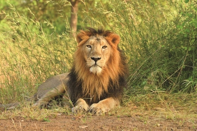
The Asiatic lion is a Panthera leo leo population in India. Its current range is restricted to the Gir National Park and environs in the Indian state of Gujarat. Historically, it inhabited much of Western Asia and the Middle East up to northern India. On the IUCN Red List, it is listed under its former scientific name Panthera leo persica as Endangered because of its small population size and area of occupancy.


The Asiatic lion's fur ranges in colour from ruddy-tawny, heavily speckled with black, to sandy or buffish grey, sometimes with a silvery sheen in certain lights. Males have only moderate mane growth at the top of the head, so that their ears are always visible. The mane is scanty on the cheeks and throat where it is only 10 cm (3.9 in) long. About half of Asiatic lions' skulls from the Gir forest have divided infraorbital foramina, whereas African lions have only one foramen on either side. The sagittal crest is more strongly developed, and the post-orbital area is shorter than in African lion. Skull length in adult males ranges from 330 to 340 mm (13 to 13 in), and in females from 292 to 302 mm (11.5 to 11.9 in). It differs from the African lion by a larger tail tuft and less inflated auditory bullae. The most striking morphological character of the Asiatic lion is a longitudinal fold of skin running along its belly.


Picture Credit : Google


The Thar Desert has among the largest numbers of which critically endangered species, also the State bird of Rajasthan?


Great Indian Bustard (GIB) is a large bird with a horizontal body and long bare legs, giving it an ostrich like appearance, this bird is among the heaviest of the flying birds. The GIB lost to the peacock in the race to become national bird of India. Now it is on the verge of extinction due to modernization of agriculture practises and rapid infrastructural developments. Rajasthan government in collaboration with the Wildlife Institute of India (WII), is formulating a long-term plan to save its state bird, The Great Indian Bustard (GIB) from extinction.


Great Indian bustards make local movements but these are not well understood although it is known that populations disperse after the monsoons. Males are said to be solitary during the breeding season but form small flocks in winter. Males may however distribute themselves close together and like other bustards they are believed to use a mating system that has been termed as an "exploded or dispersed lek". The male is polygamous.


The habitat where it is most often found is arid and semi-arid grasslands, open country with thorn scrub, tall grass interspersed with cultivation. It avoids irrigated areas. The major areas where they are known to breed are in central and western India and eastern Pakistan. The dry semi-desert regions where it was found in parts of Rajasthan has been altered by irrigation canals that have transformed the region into an intensively farmed area.


Picture Credit : Google


The Ladakh region is said to have the highest number of which big cat species in the country?


The snow leopard (shan) once ranged throughout the Himalaya, Tibet, and as far as the Sayan Mountains on the Mongolian-Russian border; and in elevation from 1800 m to 5400 m. They are extremely shy and hard to spot, and as such not well known. It is believed there are about 200 in Ladakh. Other cats in Ladakh are even rarer than the snow leopard: the lynx (ee), numbering only a few individuals, and the Pallas's cat, which looks somewhat like a house cat. The Tibetan wolf (shangku) is the greatest threat to the livestock of the Ladakhis and as such is the most persecuted. There are only about 300 wolves left in Ladakh. There are also a very few brown bears (drenmo / tret) in the Suru valley and the area around Dras. The red fox (watse) is common, and Tibetan sand fox (watse) has recently been discovered in this region.


The snow leopard is distributed from the west of Lake Baikal through southern Siberia, in the Kunlun Mountains, in the Russian Altai mountains, Sayan and Tannu-Ola Mountains, in the Tian Shan, across Kazakhstan, Kyrgyzstan, Tajikistan, and Uzbekistan to the Hindu Kush in eastern Afghanistan, Karakoram in northern Pakistan, in the Pamir Mountains, and in the high altitudes of the Himalayas in India, Nepal, and Bhutan, and the Tibetan Plateau. In Mongolia, it is found in the Mongolian and Gobi Altai Mountains and the Khangai Mountains. In Tibet, it is found up to the Altyn-Tagh in the north.


Picture Credit : Google


What is a mud lion?


Also called yardangs, mud lions form in deserts where conditions are hot and dry. When winds full of sand blow forcefully in one direction against rock, the rock is abraded over a period of time, sometimes hundreds of years, into fantastic shapes. Yardang is Turkic for ‘steep bank’. In China, they are sometimes known as yadan from the Chinese transcription of the Uyghur form of the same name.


Soft rock such as limestone and sandstone lend themselves materials can also form mud lions.


Mud lions are often seen in clusters or in a long ridge. Though the name suggests an animal shape, a yardang can resemble a human figure or a building-like structure.


In Africa, especially in the Egyptian desert, there are numerous yardangs. A large concentration of mega-yardangs are found near the Tibesti Mountains in the central Sahara. In fact, some historians and geologists think that the Sphinx of Giza might have begun as a mud lion which inspired sculptors to carve it further into its present form! There is a famous yardang at Hole in the Rock in Papago Park in Phoenix, Arizona, a rock formation with a roughly circular hole in it. Another yardang in Arizona is Window Rock, near the town of Window Rock. It is a 60-metre sandstone hill with a very large circular hole in the middle of it. Some of the mud lions in the desert areas are so battered by wind that they have tunnels bored into them!


Picture Credit : Google


What are pet rocks?


In April 1975, an American Gary Dahl told his friends that he had the perfect pet. It required no maintenance, was cheap and always obedient. Dahl was referring to his pet rock! He meant it as a joke, but his advertising colleagues jumped on the idea. As if to prove the fact that Americans would buy anything if it was marketed cleverly, pet rocks became a fad!


Dahl wrote The Pet Training Manual in two weeks. It guided owners on how to  house – train and build a rapport with their rocks. They could teach the rock tricks such as how to play dead and roll over.


Dahl then created a pet rock to go with the manual. He bought a Rosarita Beach Stone, a round gray pebble that was the most expensive one in the builders’ supply store. He packed it in soft wood shavings inside a decorative pet carrying case and added the manual. Amazingly, more than 5 million Pet Rocks were sold all over the U.S. at $3.95 apiece. Originally, the Pet Rocks were plain, but Dahl added to the line, creating rocks with faces painted on them, birth certificates and even several pebbles sold together as a family.


Before the fad petered out, Dahl became an overnight millionaire and celebrity, appearing on The Tonight Show with Johnny Carson.


Picture Credit : Google


Which is the only country in the world with three capitals?


There are a small minority of countries in the world which have more than one capital. However, the only country in the world to have three capitals is South Africa.


The South African Government is divided into three sections and therefore, based in three diverse capitals. The notion behind this came from the Union of South Africa when it was created and concern was raised over whether it would place too much power in one place to have a single capital of South Africa.


The three different capitals of South Africa are divided into administrative, legislative and judicial government bases.


The administrative capital of South Africa is Pretoria. Pretoria was the capital of Apartheid South Africa and is situated in the northern province of Gauteng. South Africa’s legislative capital is Cape Town. Home to the Cape Floral Kingdom, this capital is more than the parliamentary center of South Africa. The judicial capital of South Africa is Bloemfontein. Its name means “blooming flowers” or “fountain of flowers” in Afrikaans. 


Picture Credit : Google


What are the three waterbodies that meet in Kanyakumari?


Apart from being the southernmost tip of mainland India, Kanyakumari is also the place where three majestic water bodies – Indian Ocean, Bay of Bengal and Arabian Sea meet. While the natural beauty of the oceans, waterfalls and forests in close proximity is breathtaking, one man-made wonder which adds to it is the Thiruvalluvar Statue.


The only way to reach the statue is via ferry which can be taken from the mainland and also drops travellers off at Swami Vivekananda Rock Memorial.  Once at the spot, you can climb up for a view of the mainland and the ocean via stairs, which is must-try if you have the stamina for it. 


Thanumalayan temple is world-famous for its holy trinity of Shiva, Brahma, and Vishnu. The temple is also the abode of Lord Hanuman whose statue is 22 ft high. The temple is famous for its ancient architecture representing famous Gopurams, Musical pillars, Exquisite carvings. The musical pillar is carved out of single granite stone and is 18 feet high. The temple gives you a powerful spiritual aura living you blessed and confident.


Picture Credit : Google


Which are the two most populous countries in the world?


China and India combined currently account for 38 per cent of the world’s population, with 1.43 billion and 1.37 billion people respectively.


However, India is projected to overtake China by 2027, according to the UN’s 2019 World Population Prospects report.


The change is expected to come about as a result of the death rate exceeding the birth rate in China, whose population is projected to fall by 31.4 million between 2019 and 2050.


Meanwhile, India’s population is forecast to increase to 1.5 billion.


Picture Credit : Google


On which river bank did the Battle of the Hydaspes happen?


Battle of the Hydaspes, (326 BCE), fourth and last pitched battle fought by Alexander the Great during his campaign of conquest in Asia. The fight on the banks of the Hydaspes River in India was the closest Alexander the Great came to defeat. 


The battle took place on the east bank of the Hydaspes River (now called the Jhelum River, a tributary of the Indus River) in what is now the Punjab Province of Pakistan. Alexander later founded the city of Nicaea on the site; this city has yet to be discovered. Any attempt to find the ancient battle site is complicated by considerable changes to the landscape over time. For the moment, the most plausible location is just south of the city of Jhelum, where the ancient main road crossed the river and where a Buddhist source mentions a city that may be Nicaea. The identification of the battle site near modern Jalalpur/Haranpur is certainly erroneous, as the river (in ancient times) meandered far from these cities.


Alexander had to subdue King Porus in order to keep marching east.[citation needed] To leave such a strong opponent at his flanks would have endangered any further exploits. Alexander could not afford to show any weakness if he wanted to keep the loyalty of the already subdued Indian princes. Porus had to defend his kingdom and chose the perfect spot to check Alexander's advance. Although he lost the battle, he became the most successful recorded opponent of Alexander.


Picture Credit : Google


In which country does River Kwai flow?


The River Kwai, more correctly ‘Khwae Noi’ or Khwae Sai Yok is a river in western Thailand, near, but not over the border with Myanmar. It begins at the confluence of Ranti, Songkalia and Bikhli Rivers. 


The river is chiefly known from the Pierre Boulle novel and David Lean film The Bridge on the River Kwai, in which Australian, Dutch and British prisoners of war were forced by the Japanese to construct two parallel bridges spanning the river as part of the Burma Railway, also called the Death Railway, for the many lives lost in its construction. One bridge was wooden and temporary. The other was made of concrete and steel and still exists. The bridges actually spanned the Mae Klong, but as the railway subsequently follows the Khwae Noi Valley, the bridges became famous under the wrong name. In the 1960s, the upper part of the Mae Klong was renamed the Khwae Yai (big tributary”).


River Kwai Noi also runs through a national park, Saiyok National Park. The park’s area is approximately 500 square kilometers. Its landscape and scenery are arguably the most beautiful places in Thailand where once the famous Death Railway passed though Sai Yok Noi. The park’s major attractions are its waterfalls, including Sai Yok Yai waterfall which flows into the Khwae Noi river (River Kwai Noi).


Picture Credit : Google


Why is the Yellow River often referred to as "China's Sorrow"?


The Yellow River is also called "China's Sorrow". Each year, over 1.6 billion tons of soil flows into the Yellow River, which causes the continual rise and shift of the riverbed. Before damming, it was extremely prone to flooding, and had caused millions of deaths, including the deadliest disaster in human history.


With global warming, decrease in rainfall in the Yellow River Basin, and increasing water demands for irrigation, industry, etc., the Yellow River has been used up by its lower reaches since 1972, when it ran dry for the first time in recorded history. The longest dry period lasted 226 days in 1997.


Drought in the Yellow River region has brought serious challenges to agricultural development and the cities near the Yellow River.


What's worse, the river has been abused. It has become so polluted in some reaches that it is unfit for agricultural and industrial use, because of the huge increase in factory and sewage discharges from China's fast-expanding cities.


The government is taking measures to deal with Yellow River pollution, such as setting limits on the volume of major pollutants discharged into rivers and lakes, and controlling overuse of water resources.


Picture Credit : Google


The 1908 flooding of which river divides Hyderabad into the historic old city and the new city?


As Kerala grapples with a deluge of unimaginable proportions, the second time in under 100 years, it is interesting to remember the Hyderabad experience. Around 110 years ago on September 26, 1908, it began to rain in the surrounding areas of Hyderabad as a result of a cyclone in the Bay of Bengal. Over the next 48 hours, the downpour continued in the Musi river basin logging 98.57 cm rainfall. Of the 788 tanks and lakes in the river basin, 221 breached due to the cloudburst. 


According to historian Benjamin Cohen, the flood and deaths were used by the Nizam and his advisers to remake the city in a way that made it flood-proof. It also changed the power equations of the city.


Picture Credit : Google


From which river the Dead Sea receives almost all its water?


The northern half of the western shore lies within the Palestinian West Bank and has been under Israeli occupation since the 1967 Arab-Israeli war. The Jordan River, from which the Dead Sea receives nearly all its water, flows from the north into the lake.


The Dead Sea has the lowest elevation and is the lowest body of water on the surface of Earth. The Dead Sea lies in a desert. Rainfall is scanty and irregular. Al-Lis?n averages about 2.5 inches (65 mm) of rain a year, the industrial site of Sedom (near historical Sodom) only about 2 inches (50 mm). 


The waters of the Dead Sea are extremely saline, and, generally, the concentration of salt increases toward the lake’s bottom. That phenomenon can create two different masses of water in the lake for extended periods of time. Such a situation existed for some three centuries, lasting until the late 1970s.


Picture Credit : Google