Where the religious festival of Ramadan is celebrated?


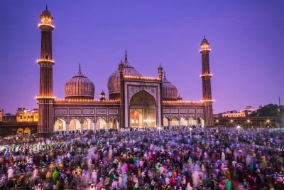
Fasting is an important part of the religion of Islam practiced by Moslems. The fast takes place during a period known as Ramadan. This is a lunar month, or twenty-eight days, before the time of the pilgrimage to Mecca. This month was chosen because it was then that ‘the Koran was sent down as guidance for the people’.


According to the Koran, during Ramadan all Moslems who have reached the age of reason must not eat or drink between dawn and dusk.


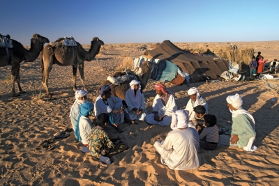
African Moslems also practice Ramadan very carefully. In the city of Fez, for example, where there is a famous Arab university, students are excused work during Ramadan so that they can pray and mediate.


In Tunisia Ramada is observed with great solemnity during the fourteenth and twentieth days. Government ministers take part in the religious ceremonies. The Libyan people also observe the fasting period with great solemnity. In Senegal, in western Africa, there are many practicing Moslems. Only special cases are allowed to break the day-long fasts. These include the very young, the old, the sick and people who are travelling.


Ramadan ceremonies are very impressive and sometimes last for several days. They usually take place towards the end of Ramadan to bring this month to a fitting conclusion. This day is called ELD.


Picture Credit : Google


Where to find the Victoria Falls?


The Zambesi is one of Africa’s longest rivers and gives rise to the world-famous Victoria Falls. These falls were named by the British missionary and explorer David Livingstone who became the first European to see them in 1855.


Livingstone was then exploring the upper reaches of the Zambesi, a river which was almost unknown. The Africans knew where to find this mighty course of water which they called ‘the smoke that thunders’ because of the noise the falls make as they drop over the cliff. But the Africans were afraid of taking Livingstone to the place: they were superstitious and feared they would be punished by the gods whom, they believed, lived inside the falls. Livingstone succeeded in persuading the Africans to help him and at last he was able to see one of the most impressive sights in the world as the Zambesi plunged 108 metres down a narrow gorge.


Livingstone was able to produce an almost perfect map of the Zambesi’s course, showing the exact location of the Victoria falls. They are situated at the far eastern end of the border that separates Zambia from Zimbabwe. It was not until the railway from Bulawayo was opened in September 1905, however, that many people were able to visit the falls.


Picture Credit : Google


Where to find the world’s largest forest?


The world’s largest forest covers and vast rivers basins of the Amazon and the Orinoco. The enormous growth of vegetation in this zone is due to its proximity to the equator. It is extremely warm and the air is very humid because of the heavy rainfall that can last from six to eight months.


The sub-equatorial forest is dense and impenetrable with many layers of vegetation, each growing to a different height. Flying over such a forest in an aeroplane one can only see the tops of the highest trees which, massed together, give the impression of an immense sea of green from which only those trees with very tall trunks emerge to heights of more than 40 metres.


Underneath this top layer grow tree ferns and beneath them are shrubs, grasses and climbing plants known as lianas. Human beings or large animals can only go through such forests by following the almost invisible tracks made by animals going to their water holes.


Picture Credit : Google


Where to find Death Valley?


The American pioneers gave this grim name of Death Valley to a very deep depression in Inyo, California, which at its bottom lies 85 metres below sea level. The entire valley had to be crossed by the prospectus in search of the famous gold deposits of California and many of these men lost their lives in Death Valley, dying of exhaustion and thirst. The pools of water that form in certain parts of the valley’s floor are extremely salty, the climate is torrid and not one blade of grass grows there. It is a real hell-on-earth and the gold prospectors struggled to get through it, but often it was the end to get through it, but often it was the end of their hopes. In the 1870s when gold was discovered in the nearby mountains, thousands of skeletons of dead animals left behind by the pioneers marked the Death Valley trail. Hundreds of Crosses littered the route and the ground was covered with wooden crosses on the graves of those people who had paid with their lives for the attempt to pass through its desolate wastes.


Picture Credit : Google


Where gold fever broke out in the Wild West?


The gold in America began on the day when a certain James Marshall discovered the first nuggets quite by chance in the waters of the river Sacramento. It was 24 January 1848. The news that California had major gold deposits soon spread far and wide. The gold rush turned into a frantic stampede towards the regions of the river Sacramento by gold prospectors and adventurers. Those who did not want to waste time on the long sea journey by way of Cape Horn (the Panama Canal had not yet been opened), faced the terrible hardships of the Oregon trail, crossing the Sierra Nevada mountains and coping with all the difficulties of such a journey Nevertheless tens of thousands of people went to the west, lured on by dreams of riches.


In 1848 California had 22,000 inhabitants. Ten year later this figure had grown to 225,000. Some of the prospectors became rich but others were bitterly disappointed. Later gold was also discovered in Colorado, Nevada, Montana and in the Yukon.


Picture Credit : Google


Where the first inhabitants of America came from?


According to the latest students the first human beings appears to have come to America about 20,000 years ago. This was during one of the great Ice Ages that affected the Earth during the Quaternary Era of its history. At that time enormous glaciers joined Asia and North America, forming a natural bridge between the two continents across the Bering Strait. It was over this bridge that waves of Asiatic people of mongoloid stock passed, pushing on farther to the south as time went on.


Little by little these peoples grew accustomed to their new surroundings and their descendants completed the occupation of the entire American continent, reaching its southernmost tip at what is now Tierra del Fuego. The descendants of those ancient peoples still live in that region.


Picture Credit : Google


Which is the America’s biggest river?


The Mississippi is about 3,760 kilometres long. With its two huge tributaries, the Missouri and the Ohio, it drains a vast area, emptying the water from thirty-one states and two Canadian provinces into the Gulf of Mexico. The enormous delta of the Mississippi starts in Louisiana, about 400 kilometres from the sea. At this place an arm of the river flows away from the main course and becomes the river Atchafalaya. Beyond this point the Mississippi opens out like a fan and develops several mouths when it reaches the sea.


The Mississippi divides the United States into two clear-cut regions. In the east lie the well-watered lands which were once covered in forests but are now intensively farmed; in the west lie the prairies which are bordered by dry, desert regions, on the slopes of the Rocky Mountains. Up to the point where it meets the Ohio River, the Mississippi follows a steep downward course and flows between rocky banks. Once it has reached the flat land of the plains, it meanders and flows very slowly. Often the surrounding land is lower is than the river itself and at these places strong ramparts and flood barriers have been built, but it has not always been possible to escape the disastrous floods that happen when the river bursts its banks. Large boats can sail up the Mississippi as far as New Orleans which is about 160 kilometres from the delta; smaller ships can go as far as Baton Rouge.


The Mississippi was discovered by Hernando de Soto in May 1541. It source, however, remained a mystery until 1832 when Henry Rowe Schodcraft found it is a small lake in Minnesota, which he named Itasca from the Latin veritas caput (true head).


Picture Credit : Google


Where to find the world’s most famous waterfalls?


The most famous waterfalls in the world are at 500,000 tons of water rush over the Niagara precipice into a gorge below every minute and make this one of the best sources of hydroelectric power in America. The dull roar of the waters can be heard from a great distance. The people who live near the falls are used to the sound and would be quite nervous if it should suddenly stop. This almost happened one night in March 1848 when the waters of the river Niagara were blocked by huge masses of ice and the great falls were reduced to a trickle for a few hours.


There are two falls at Niagara and they are separated by a huge rock, called Goad Island. The larger of the falls is in Canada and the other is in the United States. Engineers have bored a tunnel in the rock through which people can go to see the marvelous spectacle. The falls are very beautiful in winter because of the ice round them. They are visited by over 4 million sightseers a year.


Picture Credit : Google


Where the Bedouin live?


Today the word ‘Arab’ means any person who lives in a group of countries in western Asia or northern Africa such as Egypt, Algeria or Jordan. But the true Arabs are a people who live in the Arabian peninsula, across the Red Sea from place to place with their herds of goats, sheep or camels. In fact, the word ‘Arab’ means ‘normad’ in Arabic. These nomadic people are known as the Bedouin. They live in a region called in Arabic bajia, that is a vast plain with very little vegetation. Although the Bedouin make up about one-tenth of the total population of the Middle East, they occupy nearly nine-tenths of its area.


It is very difficult to trace the origins of the Bedouin. They have never learned to read or write and so have kept no records of their past. In the days of the ancient Romans the Bedouin frequently raided the coastal regions. The Romans had to build many forts to stand up to these attacks. The Bedouin used to gather together every so often in major centers of the Arab world such as Aleppo, Mecca and Hormuz. It was at these gathering that Mohamed, the prophet who is today honoured by Moslems all over the world as the founder of the Islamic religion, first preached his religious teachings.


The Bedouin live a difficult life. The Arabian desert where they live is extremely hot and water is very scare as rain does not fall for several years in certain parts. The Bedouin therefore have to keep moving to look for food for themselves and their animals. They live in tents and breed camels which they sell at markets for such foods as barely and dates. With the coming of industry of Arabia following the discovery of oil, many Bedouin have given up their wandering life and taken jobs on oilfields. Now they are much richer than the rest of the world.


Picture Credit : Google


Which city is called the ‘Venice of the East’ and why?


Thailand is an ancient kingdom in eastern Asia that was known as Siam until 1948. Its capital city, Bangkok, is a beautiful place situated on the banks of the river Maenam, about 33 kilometres from the sea. Bangkok is criss-crossed by many canals which have won the city the name of ‘Venice of the East’. Bangkok is also famous for its gardens and the hundreds of pagodas, tall, ornamental towers. The canals of the city are thronged with people on sampans, the traditional boat of Thailand, which are used to carry goods, and as shops and even homes for families.


About a fifth of the population of Bangkok lives on the waterways, working, trading, shopping, cooking, eating and sleeping on sampans. Few of the streets and modern buildings are more than fifty years old for it was only after 1900 that most of the modern buildings were constructed. Bangkok has several hundred Buddhist temples. Among the most famous are Wat Pho which has a huge gilded reclining Buddha, and the marble temple of Wat Benchamabopit. The vast Grand Palace includes the Dusit throne hall and the king’s chapel which contains a sacred jasper image of Buddha. These shrines are one reason why Bangkok attracts many tourists every year.


Picture Credit : Google


Which river contains ‘waters that purify’?


The Ganges is the sacred river for the people of India who believe that its waters have been blesses by God to cleanse and purify any person who baths in them and has faith.


Every year millions of Hindu Pilgrims bathe in the waters of the Ganger, believing the purification will affect not only themselves but their children and their children’s children as far as the seventh generation. When Hindus die their bodies are cremated and their ashes scattered on the Ganges.


The Ganges is about 2,700 kilometres long. The larger of its two main headstreams rises near the Tibetan border; the smaller begins in a cave of ice on the southern slopes of the Himalayas. Many tributaries flow into it, including the Jumna which is 1,376 kilometres long. The Ganges flows steadily for much of its course. Its waters come from steadily for much of its course. Its waters come from the glaciers in the Himalayas and from the torrential rain brought by the monsoon winds.


The valley of the Ganges is one of the most fertile and densely populated regions of India. The river flows through the holy city of Benares, and the large city of Calcutta, before emptying into the Bay of Bengal.


Before it reaches the sea, the Ganges joins with another great river, the Brahmaputra, forming a waterways and covered mainly by dense jungle.


Picture Credit : Google


When the Great Wall of China was built?


This gigantic fortification was designed as a defensive barrier to protect the Chinese empire against attacks from invading hordes of barbarians. The Great Wall was built along the northern border of China from about 200 B.C. Local feudal lords had already built some walls and forts many years previously in places such as gaps in the mountains where enemy soldiers could easily slip through into China. It was not until the great emperor Shih Huang Ti who reigned from 221 to 210 B.C. that all these walls and forts were linked up and extended as one barrier.


The great wall reached a length of about 2,400 kilometres, the longest wall ever built, winding its way up mountains and down into valleys. The height of the wall ranges from 6 to 16 metres and along its top there used to be a road more than 4 metres wide. Every so often there was a huge tower where soldiers lived and kept guard.


Picture Credit : Google


Where was the city of Troy?


Until the 1850s many historians thought that the great adventures described by Homer in the Iliad and Odyssey were all fables which had existed only in the poet’s imagination. But between 1870 and 1890 excavations carried out by as German businessman, Heinrich Schliemann, established not only that the great city had actually existed but that nine different Troys had stood on the Spot. Each city had been destroyed and a new one rebuilt during a period of 3,000 years.


Later excavations by other archaeologists confirmed Schliemann’s belief that these ruins were really the remains of Troy. The archaeologists also found that the great battles and siege in which this city, ruled by King Priam, was destroyed. Today we are certain that Troy did exist and that its towers rose from the summit of a hill called Hsarlik that now stands in Turkey by the waters of the Hellespont.


Picture Credit : Google


Which is the most beautiful city in Japan?


The cities of Japan have grown extremely rapidly since the Second World War mainly because of the spread of new industries which provided work for people but made the cities rather ugly. One city escaped this fate: Kyoto, the ancient capital of Japan founded by the Emperor Kwammu in A.D 794. For a thousand years Kyoto was the capital of the Japanese empire. During this time it became rich in monuments and the architecture of its buildings resembled that of Chinese cities. Kyoto has stout walls built all round it as a defence against attackers and the city was approached through eighteen gates in the walls. Inside were many gardens and temples of the Buddhist and Shinto religions.


Kyoto is also famous for its works of art and craftsmanship, especially porcelain and silks, and is today visited by many tourists.


Picture Credit : Google