Where is the world's largest freshwater lake?

Russia's Lake Baikal is the deepest and oldest lake in the world, and the largest freshwater lake by volume. Famous for its crystal clear waters and unique wildlife, the lake is under threat by pollution, poaching and development.

Plant and animal life in the lake is rich and various. There are between 1,500 and 1,800 animal species at different depths, and hundreds of plant species live on or near the surface. The majority of the species are endemic to Baikal. There are some 50 species of fish, belonging to seven families; the most numerous of these are the 25 species of gobies. The omul salmon is heavily fished; also important are the grayling, lake whitefish, and sturgeon. Unique to the lake is a fish called the golomyanka, of the family Comephoridae, which gives birth to live young. The one mammal species is the Baikal seal, or nerpa (Phoca sibirica). There are more than 320 bird species in the Baikal area.

Industries along the shores of Baikal include mining (mica and marble), the manufacture of cellulose and paper, shipbuilding, fisheries, and timber. There are many mineral springs, and visitors come to Goryachinsk for the curative properties of the waters. A pulp and paper mill built on Lake Baikal’s southern shore in 1966 drew strong environmental protests from Soviet scientists and writers because its wastes were polluting the water, and in 1971 the Soviet government adopted a decree to protect the lake from polluting emissions. Further pollution controls were resisted, however, and industrial waste at the site remained a concern in the late 1990s.

Credit : Britannica

Picture Credit : Google

Which country appears to be the largest?

Russia is the largest country in the world with an enormous land area of about 17million sq km. extending over a vast expanse of eastern Europe and the whole of northern Asia. Russia is so vast that it covers 11 time zones of the 24 the world is divided into. So time difference exists among regions within the country. That means when the eastern part of Russia is in the middle of the day, the western part is experiencing midnight.

The Russian economy grew strongly during the first decade of the 20th century, and in 2009 the Russian population saw a small but significant increase. The increase was reported as between 15,000 and 25,000 people and was attributed to a falling death rate and increasing migration.

There are also indications that birth rates may be increasing slightly – probably due to a combination of increased confidence in Russia’s economic prospects and government incentives to new mothers -- especially a $10,000 payment which is made to mothers who have three or more children.

Population growth and demographics have long been a problem for Russia, as a decade ago the nation was losing 1 million people a year, and many doubt Vladimir Putin's plans will work. Time will tell if Russia is able to overcome its issues and see greater growth, as otherwise it will be prone to collapsing infrastructure with its massive land area and untapped natural resources.

Picture Credit : Google

Which is the 3rd largest diamond?

A gem-quality diamond weighing more than 1,000 carats has been discovered in Botswana, a country in South Africa. What's special about this diamond, you might ask. Well, it could be the third-largest white diamond mined in history.

Who unearthed it?

The 1,098-carat diamond was unearthed by the diamond firm, Debswana, on June 1. Further, it is said to be the largest gem-quality rough diamond ever recovered by the firm in its history of over five decades in operation. Debswana is a joint venture between global diamond giant De Beers and the government of Botswana. The new stone, found in the Jwaneng mine, is yet to be named. Considering only white diamonds, the Debswana discovery would be the world's third-largest.

Biggest diamond

The diamond is the hardest natural substance found on Earth. Diamonds form 90-120 miles beneath the surface of the Earth under extreme heat and pressure, and are carried to the surface by volcanic eruptions. Most diamonds found are between one and three billion years old. There are different gradations of diamonds, ranging from flawless (the most rare) to industrial stones used in cutting. Besides jewellery making, diamonds have varied uses in health, beauty, medicine, and industries.

Large diamonds are rarely found. So far, only five 1,000 carat-plus diamonds have been excavated. The biggest diamond ever mined was the 3,106-carat Cullinan diamond found in South Africa in 1905. It was cut into nine separate stones, many of which are in the British Crown Jewels. The second-largest diamond, Lesedi La Rona, weighing 1.109 carat, was also found in Botswana in 2015 by Lucara Diamonds. Botswana, where diamonds were first discovered in 1967, is the world's largest producer of diamonds. Diamonds account for two-thirds of the country's exports.

Other big diamonds

Rough diamonds are classified as gem-quality, near-gem quality or industrial-quality, based on their colour, clarity, size, and shape. Though bigger, the Sewelo, a 1758-carat rough discovered in 2019 at the Karowe mine in Botswana, was not considered gem quality. It was covered in carbon, and looking like a big lump of coal.

A week after the Debswana discovery, an even bigger rock weighing 1.174.76 carat was found in the Karowe mine by Lucara. However, like the Sewelo, it's not considered 100% gem quality.

Picture Credit : Google

Which is the classical dance style of Orissa?

Odissi is one of the most elegant classical dance styles of India based on the feminine style of dancing known as Lasya, hailing from Orissa. Prevailing for more than 2,000 years, evidence proves that Odissi existed in the 2nd century, but over the centuries went through various stages of both progression and regression like other classical dances of India. Through the medium of varied movements and expressions, different stories of Hindu mythology are portrayed, particularly Vaishnavism. Nevertheless, stories from other religions are also interpreted in Odissi. Hence, Odissi is a fine representation of secularism and spiritualism.

Evolution and History

Odishee (original name) archeological sites related to Hinduism, Buddhism and Jainism and the carvings of dance and music in the Manchapuri Cave in Udayagiri, reveal that Odissi existed in the 1st to 2nd century during the reign of Jain king Kharavela. Hathigumpha inscriptions further ascertain the fact of the existence of this lyrical and graceful classical dance of India.

The "Shilpa prakasha", Odia architecture and sculptures at the Lord Jagannath Temple, the Konark Temple with a "nritya mandapa", the Brahmeshwara temple in Bhubaneshwar, are other evidences of the Odissi form. The 8th century saw the emergence of the saint composer and philosopher Shankaracharya, and in the 12th century, the saint-composer Jayadeva wrote the immortal classic Geet Govinda which is considered the mainstay of Odissi repertoire.

Odissi dancers were referred to as Maharis (devadasis). The dancers used to perform inside the sanctum sanctorum of the temple and there were other dancers who danced in the temple courtyards and further moved on to rich landlords and palaces, hence the degradation of dance started for which not only the dancers but also the society is responsible. Alongside, the traditional emergence of Gotipua (boy dancers) prevailed wherein young boys danced dressed as girls.

Technique and music

Like other classical dance styles, Odissi is also based on the text of dance and dramaturgy, Bharata Muni's Natya Sastra and Nandikesvaroa's Abhinaya Darpana. Natya Sastra mentions four vrittis (methods of expressive delivery) in vogue like Avanti, Dakshinatya, Panchali and Odra-Magadhi. Odra refers to Odissi. The Odissi technique comprises various bhangas (symmetry body bends), torso deflections and hand movements. It all starts, with the chauka (basic stance) followed by other movements in different rhythmic beats. Broadly, Odissi can be divided into two sections: movements known as pure dance and abhinaya (expressional dancing). Students start learning at an early age as it is not easy to master this art of geometrical symmetry and stylized movements.

Classical and folk music with Odia lyrics forms the music with raags like Kalyana, Nata, Baradi, Karnata, Bhairavi, Saveri, etc., are used. Musical composers like Jayadeva, Dinakrisha Dasa, Kabi Samrata, Upendra Bhanja, Banmali Dasa and Kavichandra Kalicharan Patnaik form the mainstay of the Odissi repertoire.

The performance normally begins with an invocation to Lord Jagannath known as Mangalacharan, followed with a rhythmic pure dance item known as Pallavi, a fine combination of rhythm, music and melody, Abhinaya numbers like Dashaavataram, Ashtapadis from Geet Govinda, and finally Moksham, that symbolises the union of the human soul (jeevatma) with divine soul (parmatma).

Pioneer mentors and repertoire

The pioneer mentors of Odissi are Kelucharan Mohapatra, Gangadhar Pradhan, Pankaj Charan Das and Raghunath Dutta, top dancers like Sanjukta Panigrahi, Sonal Mansingh, Ragini Devi, placed Odissi on the international platform followed with Dr Priyambada Mohanty, Laxmipriya Mohapatra and Kum Kum Mohanty and Kasturi Pattnaik further enhanced the repertoire by increasing the numbers with new choreographic items. Sharon Lowen from America and Illeana Citaristi from Italy are recognized as devoted performers.

Some of the professional dancers from Mumbai are Jhelum Paranjape, Daksha Mashruwala, Shubhada Varadkar and Debi Basu. Young talented dancers include Madhur Gupta, Vinod Kevin Bachan (disciple of Padmashri Ranjana Gauhar), Ankur Balal and Debasis Patnaik.

Credit : Guru Vijay Shanker (The Teenager Today)

Picture Credit : Google

Tripura storehouse of natural beauty

Tripura, the third smallest state in the country, is coyly located on the North-eastern most part of India, cuddled as it were on the north, south and west by Bangladesh. A little bit of its border in the East and Northeast, however, is left to Mizoram and Assam.

Decades ago, Tripura used to be referred to as inaccessible, geographically isolated and remote. Not anymore. Today it has the second busiest airport in the region, with only Guwahati ahead of it; its capital city Agartala is, population-wise, the second biggest city in the region, and well connected by road, rail, air, and lately by waterways too, thereby ridding itself of the stigma of being a land-locked state.

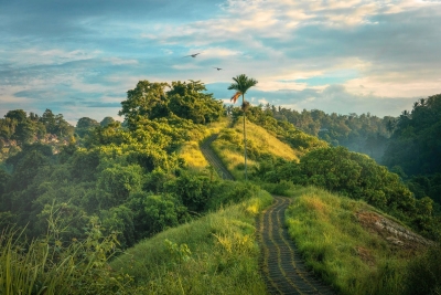
Its undulating hills sensuously clad in lush greenery conceal an ancient culture, one that is characterized by a heady mixture of gods, legends, myths, fables and folklores on the one hand, and on the other, a long line of actual flesh and blood kings, wars, struggles and earthy engagement of an entire people with nature and destiny.

The very location of Tripura 'on the other side of Bangladesh' can sound unnerving to someone not familiar with the geography of these areas. Flanked by Bangladesh on three sides, this enchanting landmass of 10,491.69 square kms is home to 3,671,032 residents (2011) who constitute 0.3% of the country's population.

Glorious past

The State of Tripura was one of the ancient princely States of India. According to the royal chronicles called Rajmala, Tripura was continuously ruled by as many as 184 Tripuri kings with sovereign and independent status prior to its merger with the Indian Union in 1949. At the time of the death of the last ruling King, Bir Bikram Kishore Deb Barman in 1947, his successor Kirit Bikram Kishore Deb Barman was hardly 12 years old, and therefore a Council of Regency was formed to run the administration under the presidency of Queen Kanchan Prava Devi, mother of Kirit Bikram Kishore Deb Barman

Among those who ruled Tripura, the Manikya dynasty is the most prominent. Since the early 15th century, it was the Manikya dynasty that ruled the Twipra Kingdom and later the princely Tripura State. At its height the dynasty controlled a large swathe of the north-east of the Indian subcontinent. After coming under British influence, in 1761 they transitioned from feudal monarchs into rulers of a princely State. The Manikyas maintained their control of the region until 1949, the year of merger with India.Kirit Pradyot Manikya Deb Barma Bahadur is the current head of Tripura Royal Family and is the 186th King Titular. He is the son of Kiri Bikram Kishore Manikya.

Ethnic mosaic

Today, indigenous communities consisting of 19 tribes and many sub-tribes form about 30 per cent of the state's population. They are broadly classified on the basis of language into Kokborok group of tribes, the Bru tribe and Halam group of tribes. With each tribe having its own distinctive forms of cultural expression - music, dance, attire, folklore and festival, it is no wonder Tripura is an invaluable storehouse of culture, traditions and ethnic diversity. The rich culture of the Bengali people who form the ethno-linguistic majority of the State further enriches the beauty and wealth of this tiny State.

Some of the tribes residing in Tripura are: Tripuri, Jamatia, Reang, Molsom, Chakma, Halam, Garo, Lushai, Darlong.

HUK 'the hearth' of culture

That Tripuri culture is predominantly agrarian in nature is clear from its folklores most of which happen in agricultural settings. Although more than half its population depends on agriculture, only about 27% of its land is available for cultivation, large swathes of land being under forest cover. Nevertheless 'huk' or the jhum cultivation traditionally practised by large number of indigenous population not only provided them with provisions needed for daily living but also became the mise en-scene in which many a drama of life unfolded. Scarcity of land and arrival of more sophisticated methods of cultivation have now considerably reduced the number of people dependent on huk.

Bamboo is a very important factor in the life and culture of the Tripura's indigenous population. They double up as just about anything that situation demands. From cutting the umbilical cord of the new born to preparation of the cremation pyre, bamboo is used. Bamboo technology has also considerably developed, thanks to initiatives by agencies like Bamboo Mission. Engaging in production of Bamboo handicrafts and furniture have today become profitable means of earning livelihood.

Gairing is a temporary watch house built on one's jhum field. The place of huk often being far from one's village and home, a work-place shelter that protects one from the elements and from wild animals is essential. Gairing is also the subject of many folklores of the Tripuri people.

Agriculture

In addition to rice which is the major crop of the state, other crops are also cultivated. Tripura pineapples are known widely and have even been exported to foreign countries in the recent years.

On the rubber map of India, Tripura occupies a pivotal position. With large areas of rural Tripura coming under rubber plantation, the state has become the second highest rubber cultivating and producing state in India. Rubber cultivation has certainly enhanced the economic prowess of those sections of the population who were able to take advantage of the opportunity.
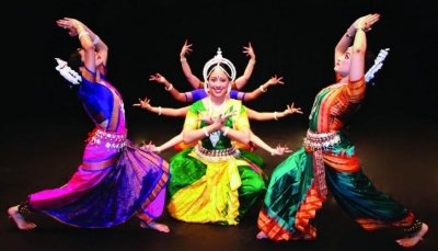
Music and dance

Like other North-eastern tribes, music and dance are an integral part of the life of Tiprasa too. Every tribe in Tripura can boast of its own songs, and its own dances. Some of the more well-known dances are: Goria dance is performed during Goria puja. Garia is an indigenous deity believed in by the Tripuri tribe and the Jamatia tribe.

Tangbiti dance is performed during the harvest season. Lebang, Mamita, and Mosak Sulmani are other dances connected to cultivation and harvest. Hojagiri dance is the unique and well known dance of Reang tribe. This dance performed by young girls, who while gracefully swaying their waist to the beat of the drum performs many acrobatic feats including balancing oneself atop an earthen pitcher and bending backwards to pick up with their teeth a kerchief placed on the ground. The Bizhu dance is performed by the Chakmas during the Bizhu festival (the last day of the month of Chaitra). Other tribal dances are Wangala dance of the Garo people, Hai-hak dance of the Halam branch of Kuki people, Sangrai dance and Owa dance of the Mog tribe, and others.

A complex form of music called 'Jaduni' is the traditional music form of the Kokborok speaking tribes. It is said that 'Jaduni' or 'jadu kolija' was used for all sorts of social interactions and expressions such as courtship, marriage proposal, mourning, lullaby, story-telling, etc. It is a pity that 'Jaduni' has nearly become extinct. However, in recent years efforts have been made to revive this intriguing and unique art form.

According to Tripuri tradition there are nine different ways of contracting a marriage. They are the following: Nok kaisa Kaimung (Marriage by exchange), Kharlai Kaijakmani (Marriage by elopement), Phuisai Tubuma (Marriage by purchase), Koklam Kwrwi Kaimung (Marriage by capture), Hamjaklai Kaijakmani (Marriage by love), Siklasogya kaimani (Child marriage), Chamariomor (Marriage by service), Chamariompa, Sundul phulmani (Widow re-marriage).

Must-see places in Tripura

Although Tripura is small in area it is a rich storehouse of natural beauty, ethnic wealth, diversity and tradition. Its hills and plains, meadows and valleys, lakes and rivers, flora and fauna, wildlife and forests, have a measure of pristine freshness and grandeur about it. Home to rich wildlife, one often hears from within its thick forests a cacophony of jungle music indicating the presence of bears, wolves, elephants, leopards, monkeys and of course numerous birds.

Thanks to its ancient history, Tripura today has numerous buildings of historical importance, some of them architectural masterpieces. They attract tourists from all parts of the country. We take a quick look at some of them.

Ujjayanta Palace: The present-day Ujjayanta Palace was built between 1899 and 1901 by Maharaja Radha Kishore Manikya Debbarma after the original palace was destroyed by a massive earthquake in 1897. Standing majestically on the banks of two lakes surrounded by gorgeous European styled gardens the palace was the home of the ruling Manikya dynasty until Tripura's merger into India in October 1949. It is now a State Museum and primarily showcases the lifestyle, arts, culture, tradition and utility crafts of communities residing in northeast India, along with a lot of stone sculptures, coinage of the Manikya dynasty and some other artifacts. It is believed the Nobel laureate Rabindranath Tagore gave the palace its name.

Neermahal: Built by Maharaja Bir Bikram Kishore Manikya between 1930 and 1938, in the middle of the lake Twijilikma at Melaghar, 53 kilometres away from Agartala, Neermahal Palace or water palace was designed to serve as his summer residence. The heavily ornate structureis said to resemble Jag Niwas Palace in Udaipur, Rajasthan, in terms of architectural style and design. Numerous migratory birds are sighted at Neermahal in certain seasons. Neermahal is a regular stopover for every tourist who comes to Tripura.

Unakoti: Unakoti, an archaeological site located in the Kailasahar subdivision of Tripura, is a visual treat for all but especially those who have a penchant for archeology. Giant-sized rock carvings spread across a significant area are a marvel to behold and are said to date back to the 7th century AD. Unakoti in Bengali means ‘one less than a crore’. According to Hindu mythology that has come to be associated with the place, it is believed that there are unakoti carvings found there, one for each of the gods and goddesses that were turned into stone by the curse of Lord Shiva.

Matarbari: Matarbari or Tripureshwari Temple of Tripura is one of the major Shakti Peethas in the country and therefore held in great reverence by devotees. Situated at Udaipur, erstwhile capital of the Tripura at the time of the Maharajas, the temple is visited by large numbers of people from near and far. The city of Udaipur, third biggest in the State, is also called 'Lake City' after the many lakes found in it.

Well-known personalities of Tripura

The annals of Tripura's history contain names of many extraordinary people who have achieved excellence in one field or other. Legendary music directors like S. D. Burman, for example, who was from Tripura's royal family. In sports, particularly swimming, quite a few from Tripura have excelled. Given below are just three 'young people who belong to the present times and have made it to international status.

Somdev Kishore Devvarman (b. 1985): Somdev is a former professional Indian tennis player whose best achievement on the ATP World Tour was reaching the final of the Chennai Open in 2009, as a wild card entry. In 2010, Somdev won the gold medal in the men's singles event of XIXth Commonwealth Games in New Delhi, and he followed it up with both men's singles and doubles gold in the 2010 Asian Games in Guangzhou, China.

Sourabhee Debbarma (b.1985): Sourabhee became the first female Indian Idol winner. She is also a Guinness World record holder. Versatile Sourabhee is a singer, performer and entertainer who has performed across India and abroad. Countries where Sourabhee has performed include Hong Kong, Nigeria, Durban, New York City, London, Kuwait, Bangladesh and Nepal.

Dipa Karmakar (b.1993): The first Indian woman and the second person from the country to clinch a Commonwealth Games medal in artistic gymnastics. She also won a bronze medal at the Asian Gymnastics Championships and finished fifth at the 2015 World Artistic Gymnastics Championships, both firsts for her country. Karmakar represented India at the 2016 Summer Olympics in Rio de Janeiro, becoming the first Indian female gymnast ever to compete in the Olympics. She missed the bronze medal by a narrow margin finishing fourth in Women's Vault gymnastics event.

Credit : Joseph Pulinthanath (The Teenager Today)

Picture Credit : Google

Why are EVs popular in Norway?

Norway is the Electric Vehicle (EV) Capital of the World. In 2020, 54 per cent of the new cars that were sold in Norway were EVs - fully electric cars and not plug-in hybrids. Norway sells 80,000 EVs per year, equal to 148 EVs per 10,000 people - 261% more than any other country. China sells over 1 million EVs a year, equal to just seven EVs per 10,000 of the population. Norway has more than 16,000 charging stations, including 3,300 fast chargers, and in 2021, 40 new electric car models will be launched. The goal is for the whole of the Norwegian car fleet to be zero-emission by 2025.

The reason EVs are so popular in Norway isn’t because Norwegians are specifically trying to be green or that they feel an outstanding sense of duty towards global citizenry. While a significant 39 per cent of Norwegians surveyed listed “environment” as one of their reasons for buying an EV, a full 64 per cent said the biggest reason for their EV purchase was “economic motivation” — EVs are incredibly cheap to own and operate in the country.

The other huge reason for the popularity of electric cars in Norway is the thorough and far-reaching network of charging stations. There are 5,600 stations in Norway and 1,400 of those within the city of Oslo. That’s one charging station per 446 cars. For Canada to have the same ratio, we would need 47,700 charging stations.

Picture Credit : Google

Why is Iron Pillar in Delhi not rusted?

The Iron Pillar of New Delhi is famous for its rust-resistant facade. Measuring 23 feet and 8 inches in height, 16 inches in diameter, and weighing 3 tonnes, it stands in the Qutb complex at Mehrauli. The pillar has attracted the attention of archaeologists and materials scientists because of its high resistance to corrosion and has been called a "testimony to the high level of skill achieved by the ancient Indian iron smiths in the extraction and processing of iron". The corrosion-resistance results from an even layer of crystalline iron hydrogen phosphate hydrate forming on the high-phosphorus content iron, which protects it from the effects of the Delhi climate. The oldest inscription on the pillar is that of a king named Candra, generally identified as the Gupta Emperor Chandragupta II (c. 375-415 CE).

The oldest inscription on the pillar is that of a king named Chandra (IAST: Candra), generally identified as the Gupta emperor Chandragupta II.

The inscription covers an area of 2?9.5? × 10.5?. The ancient writing is preserved well because of the corrosion-resistant iron on which it is engraved. However, during the engraving process, iron appears to have closed up over some of the strokes, making some of the letters imperfect.

It contains verses composed in Sanskrit language, in shardulvikridita metre. It is written in the eastern variety of the Gupta script. The letters vary from 0.3125? to 0.5? in size, and resemble closely to the letters on the Allahabad Pillar inscription of Samudragupta. However, it had distinctive m?tr?s (diacritics), similar to the ones in the Bilsad inscription of Kumaragupta I. While the edges of the characters on the Allahabad inscription are more curved, the ones on the Delhi inscription have more straight edges.

Picture Credit : Google

Which is the third largest diamond on the planet?

A 1,098-carat diamond discovered in a Botswana diamond mine is the third largest diamond on the planet. It is only smaller than the 3,106 carat Cullinan stone found in South Africa (1905) and the 1,109 carat Lesedi La Rona unearthed in Botswana (2015). Measuring 73 mm long by 55 mm wide and 27 mm thick, the gem-quality stone was discovered at Jwaneng, the world's richest mine by value. Botswana relies on diamonds for 90% of its exports.

The giant gem was uncovered June 1 in the Jwaneng mine in southern Botswana, which is considered the world's most valuable mine, according to Bloomberg. A spokesperson for mining company Debswana  — a joint venture between the De Beers corporation and the government of Botswana — said that the whopping gemstone is the largest diamond ever discovered in the company's five-decade history.

Botswana is Africa's leading diamond producer, The Guardian reported, and is also home to the mine where the world's second-largest diamond — a 1,109-carat stone called the Lesedi La Rona — was unearthed in 2015.

Picture Credit : Google

What is Nemo point in the Pacific Ocean?

At Point Nemo in the Pacific you're closer to space than anywhere on Earth! This unique spot, the farthest on the entire planet from land, goes by "the oceanic pole of inaccessibility". It is named after the famous submarine sailor from Jules Verne's 20,000 Leagues under the Sea. Located in the southern Pacific Ocean, you'd have to travel 1,000 miles from even the closest points of land to reach it. These include Motu Nui off the west coast of Chile; Ducie Island between South America and Australia; and Maher Island off the coast of Antarctica. That's so far that the closest people to Point Nemo are up in space! The International Space Station orbits just 250 miles above Earth's surface.

Point Nemo is so far from land, the nearest humans are often astronauts. The International Space Station orbits the Earth at a maximum of 258 miles (416km). Meanwhile the nearest inhabited landmass to Point Nemo is over 1,670 miles (2,700km) away.

In fact the whole region around Point Nemo is well known to space agencies.

The area is officially known to space agencies as the "South Pacific Ocean Uninhabited Area". In particular, the Russian, European and Japanese space agencies have long used it as a dumping ground, because it is the point on the planet with the fewest human inhabitants and the quietest shipping routes.

Picture Credit : Google

Which is the fifth-longest river system in the world, and the largest to drain into the Arctic Ocean?

The Yenisei River is the world's fifth-longest river system and the largest draining into the Arctic Ocean.

The world’s sixth largest river in terms of discharge, the Yenisey runs from south to north across the great expanse of central Siberia. It traverses a vast region of strikingly varied landscapes where ancient peoples and customs as well as an enormous economic infrastructure are found.

About half of the Yenisey’s water comes from snow, a little more than one-third from rainwater, and the remainder from groundwater. For the greater part of the system, the eastern Siberian hydrologic regime prevails: violent spring floods are followed first by a rapid fall of levels, then by a slower fall, with summer and autumn rain floods punctuating the sequence; in winter the runoff is reduced sharply, but levels remain high as ice jams are formed. In terms of runoff, the Yenisey is the largest river in Russia, with about 150 cubic miles (620 cubic kilometres) annually.

Hunting, fishing, the breeding of reindeer, and fur farming are the traditional occupations of the more northerly peoples, and there is some mining of coal and nonferrous ores (copper, nickel) around Norilsk. Since the 1950s, power stations have been built on the Angara at Irkutsk, Bratsk, and Ust-Ilimsk and on the upper and middle Yenisey at Krasnoyarsk and Sayan, with a combined total generating capacity exceeding 25 million kilowatts. Another station on the Angara, at Boguchany, was completed in the late 1980s. Lumber is the main cargo. Some of the cargo goes upstream to Krasnoyarsk, but the downstream traffic carries bread, coal, petroleum products, and machinery, as well as lumber.

Credit : Britannica

Picture Credit : Google

Which is the longest river in Asia and runs through nine of China’s provinces?

The Yangtze or Yangzi is the longest river in Asia, the third-longest in the world and the longest in the world to flow entirely within one country. Its drainage basin comprises one-fifth of the land area of China, and is home to nearly one-third of the country's population.

The name Yangtze—derived from the name of the ancient fiefdom of Yang—has been applied to the river mainly by those in the West. Chang Jiang (“Long River”) is the name used in China, although it also is called Da Jiang (“Great River”) or, simply, Jiang (“[The] River”). The Yangtze is the most important river of China. It is the country’s principal waterway, and its basin is China’s great granary and contains nearly one-third of the national population.

In its upper reaches the Yangtze River drains across the Plateau of Tibet, which is still uplifting as the Indian and Eurasian tectonic plates collide. The bedrock comprises an assemblage of marine sedimentary, igneous, and metamorphic rocks. Within intermontane basins, thick deposits of sediments of Cenozoic age—i.e., less than about 65 million years old—overlie the bedrock. The Yangtze descends abruptly from the Tibetan Plateau to flow across deeply eroded mountain plateaus consisting of Paleozoic and Mesozoic rocks roughly 350 to 150 million years old. In its lower reaches, the Yangtze River flows across basin fills of Cenozoic material that is about 65 to 25 million years old. These are the result of fluvial sedimentation as the Yangtze has migrated across its lower basin throughout its Cenozoic history.

Credit : Britannica

Picture Credit : Google

Which river flows through 10 U.S. States?

The Mississippi River runs through or along 10 states, from Minnesota to Louisiana, and is used to define portions of these states borders, with Wisconsin, Illinois, Kentucky, Tennessee, and Mississippi along the east side of the river, and Iowa, Missouri, and Arkansas along its west side.

Although the Mississippi can be ranked as the fourth longest river in the world by adding the length of the Missouri-Jefferson (Red Rock) system to the Mississippi downstream of the Missouri-Mississippi confluence—for a combined length of 3,710 miles (5,971 km)—the 2,340-mile length of the Mississippi proper is comfortably exceeded by 19 other rivers. In volume of discharge, however, the Mississippi’s rate of roughly 600,000 cubic feet (17,000 cubic metres) per second is the largest in North America and the eighth greatest in the world.

As the central river artery of a highly industrialized nation, the Mississippi River has become one of the busiest commercial waterways in the world, and, as the unruly neighbour of some of the continent’s richest farmland, it has been subjected to a remarkable degree of human control and modification. Furthermore, the river’s unique contribution to the history and literature of the United States has woven it like a bright thread through the folklore and national consciousness of North America, linking the names of two U.S. presidents—Abraham Lincoln and Ulysses S. Grant—with that of the celebrated author Mark Twain.

Credit : Britannica

Picture Credit : Google

Which river is the second longest in the world, although some people consider this the longest?

The Amazon River is the second longest river in the world, slightly shorter than the Nile River (4,258 miles or 6,853 km), although some experts contend that the two rivers are so close in length (since measuring methods vary and there is still some dispute over their true sources) that it is difficult to say which river is actually longer. 

The modern Amazon and its tributaries occupy a vast system of drowned valleys that have been filled with alluvium. With the rise in sea level that followed the melting of the Pleistocene glaciers, the steep-sided canyons that had been eroded into the Pliocene surface during the period of lower sea levels were gradually flooded. In the upper part of the basin—in eastern Colombia, Ecuador, Peru, and Bolivia—more-recent outwash from the Andes has covered many of the older surfaces.

There are more than 1,000 tributaries of the Amazon that flow into it from the Guiana Highlands, the Brazilian Highlands, and the Andes. Six of these tributaries—the Japurá (Caquetá in Colombia), Juruá, Madeira, Negro, Purus, and Xingu rivers—are each more than 1,000 miles (1,600 km) long; the Madeira River exceeds 2,000 miles (3,200 km) from source to mouth. The largest oceangoing ships can ascend the river 1,000 miles to the city of Manaus, Brazil, while lesser freight and passenger vessels can reach Iquitos, Peru, 1,300 miles (2,090 km) farther upstream, at any time of year.

Credit : Britannica

Picture Credit : Google

Which is the longest river in the world, stretching for 6,650 km from East Africa to the Mediterranean?

Nile River, the longest river in the world, called the father of African rivers. It rises south of the Equator and flows northward through northeastern Africa to drain into the Mediterranean Sea.

The name Nile is derived from the Greek Neilos (Latin: Nilus), which probably originated from the Semitic root na?al, meaning a valley or a river valley and hence, by an extension of the meaning, a river.

The availability of water from the Nile throughout the year, combined with the area’s high temperatures, makes possible intensive cultivation along its banks. Even in some of the regions in which the average rainfall is sufficient for cultivation, marked annual variations in precipitation often make cultivation without irrigation risky.

The Nile River is also a vital waterway for transport, especially at times when motor transport is not feasible—e.g., during the flood season. Improvements in air, rail, and highway facilities beginning in the 20th century, however, greatly reduced dependency on the waterway.

Credit : Britannica 

Picture Credit : Google