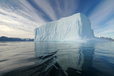
What is special about Cocos Island?

Situated more than 500 km off the Pacific Coast of Central America's Costa Rica, Cocos Island National Park spreads across more than 2,000 sq km. and includes both the Island and the protected marine regions surrounding it. Established by Costa Rica as a National Park in 1978, this remote region is said to have inspired the popular classic Treasure Island". It is made up of different kinds of land and water areas such as forested mountains, rivers, waterfalls, cliffs, beaches, bays, and coral reefs, in addition to the pelagic zone. The pelagic environment supports and witnesses large congregations of marine species, including many that are near-threatened, vulnerable, and endangered such as silky sharks, whale sharks, and hammerhead sharks. The Park was declared a UNESCO World Heritage Site in 1997 for its rich marine biodiversity. While the region sees limited human presence in the form of conservation staff, scientists, and tourists, illegal fishing in the waters has been of concern, despite monitoring. Another major threat it has faced is from invasive alien species, both plants and animals. Efforts are on to eradicate these while also watching out for new invasions.

Wildlife

Among the birds that can be spotted in the Island are grebes, teals, crakes, rails, coots, gullinules, petrels, shearwaters, pelicans, herons, egrets, frigatebirds, boobies, plovers, sandpipers, terns, gulls, ospreys, hawks, falcons, grosbeaks, flycatchers, kingfishers, orioles, swallows, and martins. The Cocos cuckoo, Cocos flycatcher, and Cocos finch are endemic to the Island. The region does not have a variety of mammals to boast of Even a few mammals such as boars introduced in the region decades ago are said to have become extinct. There are several species of insects and a few reptiles too. However, more significantly, the pelagic species that the surrounding marine ecosystem hosts is much larger and diverse. It includes several species of sharks, tuna, dolphins, and rays. The large marine animals that cross the waters include humpback whales, pilot whales, bottlenose dolphins, sea lions, and hawksbill, green and olive ridley turtles.

What is pelagic zone?

  • Pelagic zone is the entire water column or open ocean (that's not close to the bottom or coastline). It is the world's most expansive habitat. The number of creatures and species in the zone decrease with increase in depth.
  • This zone supports thousands of species in varying sizes and shapes from plankton to whales. The distribution of marine life here depends on several factors such as nutrients, prey availability, water temperature and sunlight.
  • The creatures in the pelagic zone include jellyfish, krill, many species of squids, octopuses, turtles, birds, dolphins, sharks and fish, including tuna and swordfish.
  • A few creatures such as sea birds and turtles in this zone have to travel long distances between their feeding and breeding areas. This means, they are directly in the line of threat from predators in the water or those outside of it (humans).

Picture Credit : Google
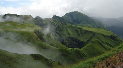
Why is Mount Nimba Strict Nature Reserve a World Heritage Site?

Covering an area of more than 180 sq.km., the Mount Nimba Strict Nature Reserve is located in the western part of Africa, straddling the borders of Guinea and Cote d'Ivoire. Towering over the region is Mount Nimba. One of the highest elevation forest ecosystems in this part of the continent, the area is a stunning mosaic of valleys, plateaus, and cliffs. The slopes of the mountain are marked by dense forests and savannahs, offering fantastic habitats for a wide variety of flora and fauna, many of them endemic to the region. The Reserve is said to support more than 2,000 species of plants, 300 species of vertebrates, and 2.500 species of invertebrates. Among its most noted endemic species are micropotamogale (otter shrew- an insectivore), the viviparous toad (unusually for a reptile, it gives birth to young ones rather than lay eggs), and "chimpanzees capable of using tools". These creatures, however, are critically endangered or are on the brink of extinction. In fact, this Reserve was declared a UNESCO World Heritage Site in 1981 for its "Outstanding Universal Value". But, 11 years from then, it fell under the "List of World Heritage in Danger, and remains there. While activities such as poaching and clearing the land for agriculture have had a negative bearing on the Reserve, long-term mining just outside of it too has been a cause of grave concern.

Wildlife

Among the birds that can be spotted here are ducks, garganeys, guineafowls, quails, francolins, grebes, pigeons, doves, nightjars, swifts, coucals, cuckoos, rails, flufftails. Turacos, storks, herons, bitterns, egrets, ibises, stilts, lapwings, plovers, jacanas, sandpipers, kites, buzzards, vultures, hawks, eagles, owls, owlets, trogons, hombills, hoopoes, honeyguides, woodpeckers, barbets, tinkerbirds, bee-eaters, rollers, kingfishers, falcons, kestrels, pittas, broadbills, orioles, cuckooshrikes, flycatchers, drongos, sunbirds, weavers, finches, waxbills, sparrows, pipits, buntings, larks, warblers, swallows, martins, babblers, starlings, and robins.

Threats

The conservation outlook for this site has been assessed as "critical" in the latest assessment cycle (2020) by the International Union for Conservation of Nature. According to the report, several aspects such as poaching, bush fires, and increasing human activity on the periphery of the Reserve are all together putting pressure on it, and causing "progressive ecological isolation of the region. Adding to the concern is the fact that "the buffer zone is not very functional in Guinea and does not exist in Ivory Coast". Further, many iron mining projects happen to occur close to Reserve's boundaries in Guinea. This points to open pit mining, and it could have a negative impact on wildlife, especially key species, and habitats, particularly if their effects are continuous. Though the Reserve straddles the borders of two countries, there is no transboundary master plan in place. In fact there is no common management system for the whole region either. This could be one of the main reasons for poaching. It could also be aggravated by the lack of good monitoring. Unlike in many regions across the world local communities here are not engaged that well in conservation initiatives or for that matter, even the development of alternative income generating activities is insufficient to reduce the pressure on natural resources”.

Picture Credit : Google

How is Northeast Greenland National Park affected by climate change?

On the world's largest island is located the world's largest national park. The Northeast Greenland National Park (in Greenland) spans more than nine-and-a-half lakh sq.km... which is, in fact, larger than several countries in the world! Also the northernmost national park in the world, it was set up in 1974 to govern this uninhabited region. It remains uninhabited to this day and has no permanent residents. While the place is visited only by researchers and scientists, sealers and whalers have regular access to the region. Offering spectacular scenery, this Park is significant as a biosphere reserve for a variety of tundra vegetation and wildlife. The region is said to have a very high concentration of musk ox close to about half the world's population.

Wildlife

While a majority of the birds here is migratory, the Park nurtures more than 50 species of permanent breeders. The birds that can be spotted here include geese, eiders, ducks, divers, fulmars, cormorants, plovers, sandpipers, razorbills, puns, skuas, gulls, terns, eagles, falcons, doves, ptarmigans, black ravens, snow buntings, pipits, and wheatears. The animals roaming the region include polar bears, seals, grey wolves, Arctic hares, Arctic foxes, caribou, walruses, and musk oxen.

Threats

Greenland's only national park is not without its share of concerns. Since the region does not have permanent residents, direct threats from humans hardly exist. However, climate change, considered by many to be the direct result of human activity has its impact on the region. Rising global temperature, rising sea levels, and intensification of extreme events are of great concern, and could impact the landscape and the wildlife of the region. In fact, a study by scientists last year revealed that another threat to Greenland's glaciers is lurking beneath the ice. It has been long-known that increasing air temperatures are adding to the surface melting on the island's ice sheet. But the new study discovered that warm ocean water moving beneath the vast glaciers is causing them to melt even more quickly. The study focussed on a glacier in northeast Greenland. Interestingly, a more recent study - earlier this month - stated that these very glaciers could help offset the effects of climate change.

A wonder material!

As a consequence of global warming, Greenland glaciers are retreating. But these retreating glaciers also expose ultra-fine silt deposit. "Known as glacial rock flour, the silt is crushed to nano-particles by the weight of the retreating ice sheet, which deposits roughly one billion tonnes of it on the world's largest island per year." It has been learnt that the silt could actually be used as nutrient-rich mud on agricultural lands for boosting agricultural output. And not just that. They also absorb carbon dioxide from the air in the process. It has been found that "adding 25 tonnes of glacial rock flour per hectare increased crop yield on barley fields in Denmark by 30%", and also "researchers from the University of Ghana, managed to increase maize yields by 30% using glacial rock flour to offset the impact of rain and heat on poor farmland", offering a glimpse of what is perhaps a rare benefit from global warming?

Picture Credit : Google