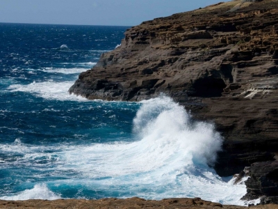
DOES THE SEA WEAR AWAY LAND?

Sea waves constantly crash into coasts, crushing rocks and pebbles. Rising waves hurl small rocks onto seaside cliffs, eroding them or tearing away at their base until they collapse. Waves and water currents carry sand and gravel that can alter coastlines. The sea and its waves can certainly wear away the land.

Coastal erosion is the wearing away of the land by the sea often involves destructive waves wearing away the coast (though constructive waves also contribute to coastal erosion).

There are four main processes of coastal erosion. These are corrasion, abrasion, hydraulic action and attrition.

Corrasion is when destructive waves pick up beach material (e.g. pebbles) and hurl them at the base of a cliff. Over time this can loosen cliff material forming a wave-cut notch.

Abrasion occurs as breaking waves, concentrated between the high and low watermarks, which contain sand and larger fragments wear away the base of a cliff or headland. It is commonly known as the sandpaper effect. This process is particularly common in high-energy storm conditions.

Waves hitting the base of a cliff causes air to be compressed in cracks, joints and folds in bedding planes causing repeated changes in air pressure. As air rushes out of the cliff when the wave retreats it leads to an explosive effect as pressure is released. This process is supported further by the weakening effect of weathering. The material breaks off cliffs, sometimes in huge chunks. This process is known as hydraulic action.

Attrition is when waves cause rocks and pebbles to bump into each other and break up.

Credit: internet geography

Picture Credit : Google

HOW DID THE AMAZON RIVER GET ITS NAME?

The Spanish soldiers who explored the region for the first time in 1541 battled native female warriors who fought bravely. The name the invaders gave to the river came from the Persian hamazan, meaning ‘those who fight together’ - also used in Greek mythology for outstanding women warriors.

Before the conquest of South America, the Rio Amazonas had no general name; instead, indigenous peoples had names for the sections of the river they occupied, such as Paranaguazu, Guyerma, Solimões, and others.

In the year 1500, Vicente Yañez Pinzon, in command of a Spanish expedition, became the first European to explore the river, exploring its mouth when he discovered that the ocean off the shore was freshwater. Pinzon called the river the Rio Santa Maria de la Mar Dulce, which soon became abbreviated to Mar Dulce, and for some years, after 1502, it was known as the Rio Grande.

Pinzon's companions called the river El Río Marañón. The word Marañón is thought by some to be of indigenous origin. This idea was first stated in a letter from Peter Martyr to Lope Hurtado de Mendoza in 1513. However, the word may also be derived from the Spanish word maraña; meaning a tangle, a snarl, which well represents the bewildering difficulties that the earlier explorers met in navigating not only the entrance to the Amazon, but the whole island-bordered, river-cut, and indented coast of what is now the Brazilian state of Maranhão.

The name Amazon arises from a battle that Francisco de Orellana had with a tribe of Tapuyas where the women of the tribe fought alongside the men, as was the custom among the entire tribe. Orellana derived the name Amazonas from the ancient Amazons of Asia and Africa described by Herodotus and Diodorus.

Credit: New World Encyclopedia

Picture Credit : Google

HOW MUCH WATER DOES THE AMAZON CARRY?

The Amazon River or River Amazon of South America has a greater total flow than the next six largest rivers combined. It is sometimes known as The River Sea. The Amazon is also regarded by most geographic authorities as the second longest river on Earth, the longest being the Nile in Africa.

The drainage area of the Amazon in Brazil, called the Amazon Basin, is the largest on Earth. If the Basin were an independent country, it would have more than twice the area of India.

The quantity of fresh water released by the Amazon to the Atlantic Ocean is enormous: up to 300,000 m³ per second in the rainy season. The Amazon is responsible for a fifth of the total volume of fresh water entering the oceans worldwide. It is said that offshore of the mouth of the Amazon potable water can be drawn from the ocean while still out of sight of the coastline, and the salinity of the ocean is notably lower a hundred miles out to sea. This mixture of fresh and salt water is known as brackish water.

This quantity of water causes the Amazon to have no clouds above the channel near its mouth. These are usually taken in the morning, when water is colder and land is beginning to be much warmer. Above big rivers (the Orinoco and Caura rivers in Venezuela and many more have the same characteristic), cold waters create a high pressure air mass which make rivers easy to see through clouds. On the contrary, during afternoons, clouds cover most river channels.

Credit: cs.mcgill.ca

Picture Credit : Google

HOW OLD IS THE COLORADO RIVER?

Colorado River, major river of North America, rising in the Rocky Mountains of Colorado, U.S., and flowing generally west and south for 1,450 miles (2,330 kilometres) into the Gulf of California in northwestern Mexico. Its drainage basin covers 246,000 square miles (637,000 square kilometres) and includes parts of seven states—Wyoming, Colorado, Utah, New Mexico, Nevada, Arizona, and California. For 17 miles the river forms the international boundary between the U.S. state of Arizona and Mexico. The river drains a vast arid and semiarid sector of the North American continent, and because of its intensive development it is often referred to as the “Lifeline of the Southwest.”

For more than a thousand miles of its course, the Colorado has cut a deep gorge. Where the river system is joined by lateral streams—the Virgin, Kanab, Paria, Escalante, Dirty Devil, and Green rivers from the west, and the Little Colorado, San Juan, Dolores, and Gunnison from the east—a transverse system of narrow, winding deep canyons has been cut. Each entering river and each lateral creek has cut another canyon, and thus the upper and middle parts of the Colorado basin are traversed by a labyrinth of deep gorges. The longest of these unbroken trunk canyons through which the Colorado flows is the spectacular Grand Canyon, extending from the mouth of the Paria to the Grand Wash Stream. Other canyons cut by the river include Marble Canyon, Glen Canyon, and Cataract Canyon. Canyonlands National Park encompasses another of these regions at the juncture of the Green and Colorado rivers in southeastern Utah.

Credit: Britannica

Picture Credit : Google

HOW OLD IS THE NILE RIVER?

The Nile River flowing through Egypt could be six times as old as previously thought, according to a study which estimated it to have originated at least 30 million years ago. The study, published in the journal Nature Geoscience, assessed the links between the geographical and physical features — or topography — of the Nile River to the flow of molten rocks in the Earth’s mantle.

The researchers, including those from the University of Texas (UT) at Austin in the US, connected the tilted nature of the Nile’s topography to a conveyor belt of mantle rock pushing up against the Ethiopian Highlands in the south, and pulling the surface down in the north. This gentle gradient, they said, keeps the Nile on a consistent northward course from its beginning to the end. The study said the Nile would have turned west long ago — probably changing the course of history along with it — if it weren’t for the mantle movement keeping the river on course.

Picture Credit : Google 

HOW DO CANYONS FORM?

A canyon is a vast, bounded valley with steep, rising sides. Canyons are formed by weathering and erosion. Over millions of years, the land is continuously worn away by water. Rocks and silt on the riverbed are carried away by the river, which further gouges out a narrow channel-shaped landscape.

A canyon is a deep, narrow valley with steep sides. “Canyon” comes from the Spanish word cañon, which means “tube” or “pipe.” The term “gorge” is often used to mean “canyon,” but a gorge is almost always steeper and narrower than a canyon.

The movement of rivers, the processes of weathering and erosion, and tectonic activity create canyons.

River Canyons

The most familiar type of canyon is probably the river canyon. The water pressure of a river can cut deep into a river bed. Sediments from the river bed are carried downstream, creating a deep, narrow channel.

Rivers that lie at the bottom of deep canyons are known as entrenched rivers. They are entrenched because, unlike rivers in wide, flat flood plains, they do not meander and change their course.

Weathering and Erosion

Weathering and erosion also contribute to the formation of canyons. In winter, water seeps into cracks in the rock. This water freezes. As water freezes, it expands and turns into ice. Ice forces the cracks to become larger and larger, eroding bits of stone in the process. During brief, heavy rains, water rushes down the cracks, eroding even more rocks and stone. As more rocks crumble and fall, the canyon grows wider at the top than at the bottom.

When this process happens in soft rock, such as sandstone, it can lead to the development of slot canyons. Slot canyons are very narrow and deep. Sometimes, a slot canyon can be less than a meter (3 feet) wide, but hundreds of meters deep. Slot canyons can be dangerous. Their sides are usually very smooth and difficult to climb.

Tectonic Uplift

Canyons are also formed by tectonic activity. As tectonic plates beneath the Earth’s crust shift and collide, their movement can change the area’s landscape. Sometimes, tectonic activity causes an area of the Earth’s crust to rise higher than the surrounding land. This process is called tectonic uplift. Tectonic uplift can create plateaus and mountains. Rivers and glaciers that cut through these elevated areas of land create deep canyons.

Credit: National Geographic Society

Picture Credit : Google 

HOW DO RIVER CURRENTS IMPACT THE LANDSCAPE?

Current refers to the speed of the movement of water. This can be very fast, especially in the mountains, close to the source of the river. River currents have tremendous power - they can tear out boulders and carry huge rocks and smash them deep into the riverbed. As the river reaches the plains, the current slows it down; causing it to deposit a lot of the debris it carried, creating a wider valley with fertile soil.

Rivers and streams begin their lives as smaller creeks, often called "the headwaters". These small tributaries flow downhill until they merge to form bigger tributaries, which continue merging to form larger rivers. Rivers keep flowing to lower altitudes, towards the oceans. River systems are similar to the blood vessels in your body. Tiny capillaries that carry blood keep merging together until all of the blood empties into large veins, which deliver the blood to your heart.

All rivers are surrounded by a certain amount of land that is higher in altitude (upgradient) than the actual river. Precipitation that falls in this area eventually flows downhill towards the river. At any particular point on a river, the land upgradient of the point is the river's watershed, or drainage basin. This example of a watershed gives a rough idea of how precipitation flows downhill into rivers (and lakes) movement of a fluid within a larger body of that fluid. Fluids are materials capable of flowing and easily changing shape. The most familiar natural fluid is water. But air is considered a fluid as well. Electricity can also flow as a current.

Air currents flow in the atmosphere, the layer of air surrounding the Earth. Water currents flow in rivers, lakes, and, oceans. Electric currents flow through power lines or as lightning.

Credit: usgs.gov

Picture Credit : Google

WHAT IS A WATERSHED?

A river can originate from the end of a melting glacier or snow. It can also start from a lake or a spring. As it flows downstream, the river is joined by many tributaries, which increase its flow to make one large river. The land area that feeds, or drains into, a specific river and its tributaries is the watershed for that river system.

A watershed is an area of land that drains or “sheds” water into a specific waterbody. Every body of water has a watershed. Watersheds drain rainfall and snowmelt into streams and rivers. These smaller bodies of water flow into larger ones, including lakes, bays, and oceans. Gravity helps to guide the path that water takes across the landscape.

Not all rain or snow that falls on a watershed flows out in this way. Some seeps into the ground. It goes into underground reservoirs called aquifers. Other precipitation ends up on hard surfaces such as roads and parking lots, from which it may enter storm drains that feed into streams.

Watersheds can vary in size. A watershed for a tiny mountain creek might be as small as a few square meters. Some watersheds are enormous and usually encompass many smaller ones. The Mississippi River watershed is the biggest watershed in the United States, draining more than three million square kilometers (one million square miles) of land. The Mississippi River watershed stretches from the Appalachian Mountains in the east to the Rocky Mountains in the west. Thirty-one U.S. states and two Canadian provinces fall within the Mississippi River watershed.

Credit: National Geographic Society

Picture Credit : Google 

HOW MANY TRIBUTARIES DOES THE NILE RIVER HAVE?

The Nile in Africa is the longest river in the world. The river has three tributaries; the two main ones are the White Nile that begins in Burundi and the Blue Nile that has its source in Ethiopia. Both rivers merge in Sudan. The third tributary, Atbara River, is dry most of the year and flows only if it rains in Ethiopia.

The Nile River, considered the longest river in the world, is approximately 4,258 miles (6,853 kilometers) long, but its exact length is a matter of debate. Flowing northward through the tropical climate of eastern Africa and into the Mediterranean Sea, the river passes through 11 countries: Tanzania, Uganda, Rwanda, Burundi, the Democratic Republic of the Congo, Kenya, Ethiopia, Eritrea, South Sudan, Sudan and Egypt.

The Nile has two major tributaries: the longer White Nile, considered the prime stream and headwaters; and the Blue Nile, which carries about two-thirds of the river's water volume and most of the silt.

The White Nile begins at Lake Victoria, Africa's largest lake, which touches the countries of Uganda, Kenya and Tanzania. But Lake Victoria isn't necessarily the most distant and "true" source of the Nile River because the lake itself has many feeder rivers coming in from the surrounding mountains. In 2006, a British explorer named Neil McGrigor said he'd traveled to the Nile’s most distant source at the beginning of the Kagera River, Lake Victoria’s longest feeder river.

Credit: Live Science

Picture Credit : Google 

WHAT IS AN OXBOW LAKE?

When a river flows through low-lying plains, it slows down, carving out a meandering path with many U-shaped curves. Over time, some of these curves become cut off from the main flow of the river by the build-up of silt deposits, and form oxbow lakes. These distinctive, curved water bodies are close to a river but separate from it.

An oxbow lake starts out as a curve, or meander, in a river. A lake forms as the river finds a different, shorter, course. The meander becomes an oxbow lake along the side of the river.

Oxbow lakes usually form in flat, low-lying plains close to where the river empties into another body of water. On these plains, rivers often have wide meanders.

Meanders that form oxbow lakes have two sets of curves: one curving away from the straight path of the river and one curving back. The corners of the curves closest to each other are called concave banks. The concave banks erode over time. The force of the rivers flowing water wears away the land on the meanders concave banks.

The banks opposite the concave banks are called convex banks. The opposite of erosion happens here. Silt and sediment build up on convex banks. This build-up is called deposition.

Erosion and deposition eventually cause a new channel to be cut through the small piece of land at the narrow end of the meander. The river makes a shortcut. Oxbow lakes are the remains of the bend in the river.

Oxbow lakes are stillwater lakes. This means that water does not flow into or out of them. There is no stream or spring feeding the lake, and it doesnt have a natural outlet. Oxbow lakes often become swamps or bogs, and they often dry up as their water evaporates.

Credit: National Geographic Society

Picture Credit : Google