WHAT IS A KAME?

A kame, or knob, is a glacial landform, an irregularly shaped hill or mound composed of sand, gravel and till that accumulates in a depression on a retreating glacier, and is then deposited on the land surface with further melting of the glacier. Kames are often associated with kettles, and this is referred to as kame and kettle or knob and kettle topography. The word kame is a variant of comb (kame, or kaim is the Old Scottish word for comb), which has the meaning "crest" among others. The geological term was introduced by Thomas Jamieson in 1874.

According to White, "kames were formed by meltwater which deposited more or less washed material at irregular places in and along melting ice. At places the material is very well washed and stratified; at others it is more poorly washed, with inclusions of till masses that fell from ice but were covered before they were completely washed. Kame gravels thus tend to be variable and range from fine to coarse grained and even to cobbly and boulder."

With the melting of the glacier, streams carry sediment to glacial lakes, building kame deltas on top of the ice. However, with the continuous melting of the glacier, the kame delta eventually collapses onto the land surface, furthering the "kame and kettle" topography.

Credit: Wikipedia

Picture Credit : Google 

WHAT ARE MORAINE RIDGES?

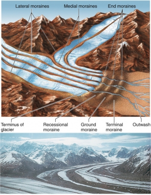
The variety of loose rocks and sediments dumped over landscape give evidence about the type of glacier and glaciation that took place in the area. A moraine ridge is the landform created by the debris left by a glacier after it has moved away. Moraine ridges are given names according to the size of debris and how they were formed. Examples are: lateral moraine, recessional moraine, medial moraine and ground moraine.

A moraine is material left behind by a moving glacier. This material is usually soil and rock. Just as rivers carry along all sorts of debris and silt that eventually builds up to form deltas, glaciers transport all sorts of dirt and boulders that build up to form moraines.

Moraines only show up in places that have, or used to have, glaciers. Glaciers are extremely large, moving rivers of ice. Glaciers shape the landscape in a process called glaciation. Glaciation can affect the land, rocks, and water in an area for thousands of years. That is why moraines are often very old.
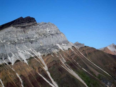
Lateral Moraine

A lateral moraine forms along the sides of a glacier. As the glacier scrapes along, it tears off rock and soil from both sides of its path. This material is deposited as lateral moraine at the top of the glacier’s edges. Lateral moraines are usually found in matching ridges on either side of the glacier. The glacier pushes material up the sides of the valley at about the same time, so lateral moraines usually have similar heights.

Medial Moraine

A medial moraine is found on top of and inside an existing glacier. Medial moraines are formed when two glaciers meet. Two lateral moraines from the different glaciers are pushed together. This material forms one line of rocks and dirt in the middle of the new, bigger glacier.

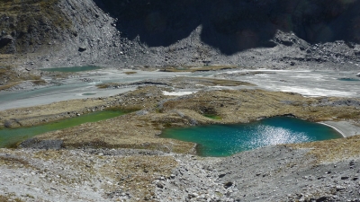
Supraglacial Moraine

A supraglacial moraine is material on the surface of a glacier. Lateral and medial moraines can be supraglacial moraines. Supraglacial moraines are made up of rocks and earth that have fallen on the glacier from the surrounding landscape. Dust and dirt left by wind and rain become part of supraglacial moraines. Sometimes the supraglacial moraine is so heavy; it blocks the view of the ice river underneath.
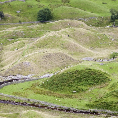
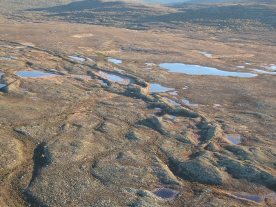
Ground Moraine

Ground moraines often show up as rolling, strangely shaped land covered in grass or other vegetation. They don’t have the sharp ridges of other moraines. A ground moraine is made of sediment that slowly builds up directly underneath a glacier by tiny streams, or as the result of a glacier meeting hills and valleys in the natural landscape. When a glacier melts, the ground moraine underneath is exposed.
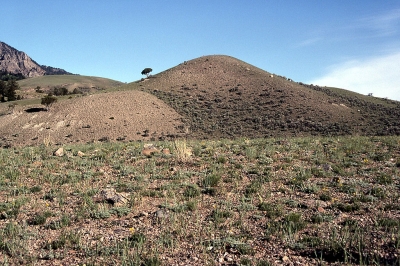
Terminal Moraine

A terminal moraine is also sometimes called an end moraine. It forms at the very end of a glacier, telling scientists today important information about the glacier and how it moved. At a terminal moraine, all the debris that was scooped up and pushed to the front of the glacier is deposited as a large clump of rocks, soil, and sediment.

Credit: National Geographic

Picture Credit : Google 

WHAT IS A KETTLE?

kettle, also called Kettle Hole, in geology, depression in a glacial outwash drift made by the melting of a detached mass of glacial ice that became wholly or partly buried. The occurrence of these stranded ice masses is thought to be the result of gradual accumulation of outwash atop the irregular glacier terminus. Kettles may range in size from 5 m (15 feet) to 13 km (8 miles) in diameter and up to 45 m in depth. When filled with water they are called kettle lakes. Most kettles are circular in shape because melting blocks of ice tend to become rounded; distorted or branching depressions may result from extremely irregular ice masses.

Two types of kettles are recognized: a depression formed from a partially buried ice mass by the sliding of unsupported sediment into the space left by the ice and a depression formed from a completely buried ice mass by the collapse of overlying sediment. By either process, small kettles may be formed from ice blocks that were not left as the glacier retreated but rather were later floated into place by shallow melt water streams. Kettles may occur singly or in groups; when large numbers are found together, the terrain appears as mounds and basins and is called kettle and kame topography.

Credit: Britannica

Picture Credit : Google 

WHAT ARE DRUMLINS?

Rounded or mound-shaped hills created by glacial ice, drumlins are often found in clusters. They are largely made up of sediment deposited by a glacier and can vary greatly in size. The name derives from a Gaelic word droimin meaning ‘smallest ridges’.

Drumlin's meaning is quite simple. Drumlins are elongated, oval-shaped or say teardrop-hills of rock, sand, and gravel. A drumlin is by and large made up of glacial drift, formed underneath an ice sheet or moving glacier and oriented in the direction of ice flow. There are no strict specifications with respect to the size of a drumlin but they tend to be up to a few kilometers up to 2 kilometers long and up to 50m in relief.

Drumlin glacier develops in the form of clusters apparently close to the terminus of glaciers. The mechanisms of formation are though disputed. They seemingly have significant interpretive value for rate and direction of glacial movement.

Drumlins are usually found in wide-ranging lowland regions, with their long axes approximately parallel to the path of glacial flow. Though they are observed in a multitude of shapes, the glacier side is always steep and high, while the lee side is tapered and smooth mildly in the direction of ice movement. Drumlins can hugely differ in size, with lengths from 1 to 2 km, heights from 50 to 100 feet, and widths from 400 to 600 m.

Credit: Vedantu

Picture Credit : Google 

HOW DO WE KNOW THAT ICE ONCE COVERED AN AREA?

A study of rocks found in an area reveals much about its past. The debris and way that sediments have been changed and distorted gives evidence of ice covering that area. Also, land eroded by ice shows certain typical landforms such as glaciated valleys with cirques, arêtes and horns. All these indicate the presence of ice sometime in the past.

Sea ice may have covered the Earth's surface all the way to the equator hundreds of millions of years ago, a new study finds, adding more evidence to the theory that a "snowball Earth" once existed.

The finding, detailed in the March 5 issue of the journal Science, also has implications for the survival and evolution of life on Earth through this bitter ice age.

Geologists found evidence that tropical areas were once covered by glaciers by examining ancient tropical rocks that are now found in remote northwestern Canada. These rocks have moved because the Earth's surfaces, and the rocks on it, are in constant motion, pushed around by the roiling currents of the planet's interior, a process called plate tectonics.

Credit: Live Science

Picture Credit : Google

WHAT IS AN ESKER?

Sometimes a stream cuts a channel under a slow-moving glacier, creating a long, winding ridge of sand and gravel that is called an esker. Before the glacier melted, the banks of these streams were defined by glacier ice. The deposited gravel now stands high above the surrounding land.

An esker is an attractive landform formed through fluvioglacial deposition. It is a winding ridge of low-lying stratified sand or gravel dominating the terrain and providing the vintage point and dry routes. An esker occurs in a glaciated area or a formerly glaciated region, especially in Europe and North America. The esker lies on valley floor within the ice margins marked by a moraine system suggesting that the eskers are formed beneath the glacier. The word esker is an Irish word meaning a ridge or an elevation which separates two plains. The term is also used to refer to ridges which are deposits of fluvioglacial material. Eskers vary in size and shapes with most of them being sinuous. The longest eskers are continuous and measure few kilometers while most of them are short and discontinuous.

Eskers are formed on washed sands and gravel. Most eskers are formed within ice-walled tunnel by streams which flow under and within glaciers. When the ice wall melts away, water deposits remain as winding ridges. Eskers can also be formed above the glacier through the accumulation of sediments in supraglacial channels. Eskers are formed at the terminal zones of glaciers where the ice is flowing relatively slowly. The melt water collects and flows through a network of tunnels. This water carries highly charged with debris which is composed of coarse-grained gravel which are stratified and sorted. The shape and size of the subglacial tunnel are determined by the flow and melting of the ice. The form of the tunnel then determines the shape and structure of an esker.

Credit: World Atlas

Picture Credit : Google