DOES ANTARCTICA HOLD MOST OF THE WORLD’S FRESH WATER?

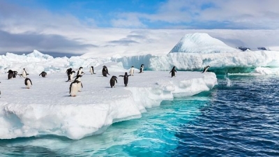
The Antarctic ice cap contains about 91% of all the ice in the world and about 86% of all freshwater that occurs in the form of ice. But despite all this freshwater, Antarctica is considered one of the most arid places on Earth.

Antarctica is the highest, coldest, driest, and windiest of the world’s continents. It is also “tallest” in terms of average height above sea level. Nearly 99% of this land mass is covered with an ice cap with an average altitude of around 2 200 metres above sea level. The area of this vast continent – some 14 million square kilometres – doubles in the winter, when sea ice can stretch as much as 1000 km outwards from the coastline.

Most of the continent of Antarctica lies south of 70°S, although the Antarctic Peninsula stretches northward as far as 60°S. The continent is surrounded by the Southern Ocean, a circumpolar sea that isolates Antarctica from the other continents.

Most of Antarctica is covered with ice, but in many places mountain peaks (nunataks) stick up out of the ice. The Vinson Massif in West Antarctica, with an elevation of 5 140 m, is the highest peak in Antarctica. In addition to the nunataks, there are large ice-free regions called oases where the ice has retreated and where melting outstrips accumulation of new snow. Other areas, known as dry valleys, are free of ice because essentially no precipitation falls there.

Picture Credit : Google 

HOW OLD IS GLACIER ICE?

  • The age of the oldest glacier ice in Antarctica may approach 1,000,000 years old
  • The age of the oldest glacier ice in Greenland is more than 100,000 years old
  • The age of the oldest Alaskan glacier ice ever recovered (from a basin between Mt. Bona and Mt. Churchill) is about 30,000 years old.

Glacier flow moves newly formed ice through the entire length of a typical Alaskan valley glacier in 100 years or less. Based on flow rates, it takes less than 400 years for ice to transit the entire 140 + mile length of Bering Glacier, Alaska’s largest and longest glacier.

Credit: USGS

Picture Credit : Google 

HOW MUCH OF THE WORLD IS COVERED BY ICE?

Almost 10 per cent of Earth’s total landmass is covered by ice. This includes glaciers, Ice caps and ice sheets. Glaciers cover 15 million km2. During the last ice age, 32 per cent of the total land area was covered by ice.

Most of the Earth’s ice that we see is to be found in large masses of “nearly” pure ice: ice-sheets and glaciers of various types, ice shelves and sea ice packs. It is quite easy to calculate the surface of the areas covered with ice: it has been calculated that this amounts to approximately 15 million km2, equal to one tenth of the surface of the Earth’s emersed land. It is more difficult, on the contrary, to calculate the volume of ice because the thickness of the entire covered area must be known: using special techniques it is possible to measure the ice thickness in various points of a glacier and therefore to estimate the volume. For example the average thickness of the Antarctic sheet is 2,100 m, with peaks of 4,800 m in Land of Wilkes, in the Eastern sector: with a surface of little less than 13,600,000 km2, the total volume of the Antarctic ice is 30 million km3.

Credit: Energy & environment

Picture Credit : Google 

WHAT IS AN ICE AGE?

A very long period, it could be millions of years, during which major parts of Earth are covered with ice because of a significant drop in temperature, is termed an ice age. Geologists say that the most recent was the Little Ice Age, which started in the 16th century in Europe and many regions across the world and reached its peak in 1850.

An ice age is a period in which the earth's climate is colder than normal, with ice sheets capping the poles and glaciers dominating higher altitudes. Within an ice age, there are varying pulses of colder and warmer climatic conditions, known as 'glacials' and 'interglacials'. Even within the interglacials, ice continues to cover at least one of the poles. In contrast, outside an ice age temperatures are higher and more stable, and there is far less ice all around. The earth has thus far made it through at least five significant ice ages.

One glance at our icy poles and frozen peaks makes it clear that our current epoch (the Holocene, c. 12,000-present day) actually represents an interglacial within the ice age that spans the Quaternary geological period, which started around 2,6 million years ago and encompasses both the Pleistocene (c. 2,6 million years ago - c. 12,000 years ago) and the Holocene epochs. This entire period is characterised by cycles of ups and downs in ice sheet volumes and temperatures which can sometimes change as much as 15°C within a couple of decades. This rapidly overturning climate can have huge knock-on effects all around the world, altering vegetation and the types of animals that can survive in certain areas, and it helped shape human evolution, too.

Credit: World History Encyclopedia

Picture Credit : Google 

WHAT IS A GLACIAL ERRATIC?

A rock resting on rocks from which it differs drastically is a glacial erratic. It would have been transported to a location many kilometres away from its place of origin by glacial erosion. An erratic can vary in size from a small rock to a very big boulder. Studying such rocks helps scientists define the path of glacial movement.

A glacial erratic is glacially deposited rock differing from the type of rock native to the area in which it rests. Erratics, which take their name from the Latin word errare (to wander), are carried by glacial ice, often over distances of hundreds of kilometres. Erratics can range in size from pebbles to large boulders such as Big Rock (16,500 tonnes or 18,200 short tons) in Alberta.

Geologists identify erratics by studying the rocks surrounding the position of the erratic and the composition of the erratic itself. Erratics are significant because:

  • They can be transported by glaciers, and they are thereby one of a series of indicators which mark the path of prehistoric glacier movement. Their lithographic origin can be traced to the parent bedrock, allowing for confirmation of the ice flow route.
  • They can be transported by ice rafting. This allows quantification of the extent of glacial flooding resulting from ice dam failure which release the waters stored in proglacial lakes such as Lake Missoula. Erratics released by ice-rafts that were stranded and subsequently melted, dropping their load, allow characterization of the high-water marks for transient floods in areas like temporary Lake Lewis.
  • Erratics dropped by icebergs melting in the ocean can be used to track Antarctic and Arctic-region glacial movements for periods prior to record retention. Also known as dropstones, these can be correlated with ocean temperatures and levels to better understand and calibrate models of the global climate.

Credit: Wikipedia

Picture Credit : Google 

WHAT IS A KAME?

A kame, or knob, is a glacial landform, an irregularly shaped hill or mound composed of sand, gravel and till that accumulates in a depression on a retreating glacier, and is then deposited on the land surface with further melting of the glacier. Kames are often associated with kettles, and this is referred to as kame and kettle or knob and kettle topography. The word kame is a variant of comb (kame, or kaim is the Old Scottish word for comb), which has the meaning "crest" among others. The geological term was introduced by Thomas Jamieson in 1874.

According to White, "kames were formed by meltwater which deposited more or less washed material at irregular places in and along melting ice. At places the material is very well washed and stratified; at others it is more poorly washed, with inclusions of till masses that fell from ice but were covered before they were completely washed. Kame gravels thus tend to be variable and range from fine to coarse grained and even to cobbly and boulder."

With the melting of the glacier, streams carry sediment to glacial lakes, building kame deltas on top of the ice. However, with the continuous melting of the glacier, the kame delta eventually collapses onto the land surface, furthering the "kame and kettle" topography.

Credit: Wikipedia

Picture Credit : Google 

WHAT IS A KETTLE?

kettle, also called Kettle Hole, in geology, depression in a glacial outwash drift made by the melting of a detached mass of glacial ice that became wholly or partly buried. The occurrence of these stranded ice masses is thought to be the result of gradual accumulation of outwash atop the irregular glacier terminus. Kettles may range in size from 5 m (15 feet) to 13 km (8 miles) in diameter and up to 45 m in depth. When filled with water they are called kettle lakes. Most kettles are circular in shape because melting blocks of ice tend to become rounded; distorted or branching depressions may result from extremely irregular ice masses.

Two types of kettles are recognized: a depression formed from a partially buried ice mass by the sliding of unsupported sediment into the space left by the ice and a depression formed from a completely buried ice mass by the collapse of overlying sediment. By either process, small kettles may be formed from ice blocks that were not left as the glacier retreated but rather were later floated into place by shallow melt water streams. Kettles may occur singly or in groups; when large numbers are found together, the terrain appears as mounds and basins and is called kettle and kame topography.

Credit: Britannica

Picture Credit : Google 

WHAT IS A BLOWHOLE?

Sometimes, the rocks along a coastline have a crevice or hole just above the low-tide mark. When the high tide rushes in, the crevice fills up with water, which tries to escape through this narrow hole. The build-up of pressure sprays out the water as an upward plume with a loud sound. This is a blowhole. Over time, a blowhole can create caves or even a pool of water near the coast.

When sea caves grow towards the land and upwards creating a vertical shaft that exposed on the surface, it results in a blowhole. Water often gushes out at the top part of the landform when waves move to the sea cave with significant force. The activities of the blowhole depend on the sea conditions as well as its geometry and that of the sea cave. A blowhole is characterized by an opening on the ground and a connection to an opening which interacts with the sea, mostly a cave.

Sea Caves are a common feature along the coasts and are formed through mechanical erosion of cliffs. Parts of weakness in the cliffs are weathered out by wave action thereby forming large cavities known as sea caves. These caves are regularly exposed to waves. Hydraulic pressure, built up by a succession of waves, eventually carves out a hole at the top of the cave to create an opening for water pressure to be expelled as a jet of spray. A blowhole can also be formed when lava flows make openings in the ground which extend towards the sea. The landform manifests as a crack or fissure once formed.

Credit: World Atlas

Picture Credit : Google