WHAT ARE SANDSTORMS?

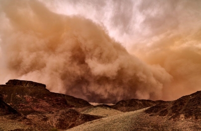
When strong winds storm across sandy deserts, they lift huge amounts of sand into the air and blow it about forcefully in what is called a sandstorm. The force and speed of the wind can carry the sand for thousands of kilometres before depositing it again. The coarseness of the particles can make a sandstorm really devastating. Smaller grains can remain suspended in the air for a long time.

A sandstorm is described as a natural phenomenon that occurs when a strong wind, such as a gust front, blows fine sand particles and dust from a dry surface. These particles become suspended in the air, causing erosion where they initially were. The wind drops these particles in another place where silt is formed.

Also known as a dust storm, a sandstorm is common in arid and semi-arid regions. The primary terrestrial sources of airborne dust include the drylands around the Arabian Peninsula and North Africa. The Takla Makan and Gobi desert of China, and the Sahara desert also experience sandstorms.

A sandstorm is usually confined to the lowest ten feet. It rarely rises to more than fifty feet above the ground. The sand particles which are picked up by the sandstorm are larger than dust particles. They usually fall out of the storm more rapidly, causing it to launch not far from where the sand was initially at.

It is thought that the particles also fall to the ocean, significantly affecting the marine ecosystem. It is worth noting that the frequency of sandstorms has been increasing, albeit a well-known meteorological phenomenon since the ancient times. It has raised several health and environmental concerns due to the gravity of its surge.

Credit: Earth Eclipse

Picture Credit: Google

WHAT ARE DRUMLINS?

Rounded or mound-shaped hills created by glacial ice, drumlins are often found in clusters. They are largely made up of sediment deposited by a glacier and can vary greatly in size. The name derives from a Gaelic word droimin meaning ‘smallest ridges’.

Drumlin's meaning is quite simple. Drumlins are elongated, oval-shaped or say teardrop-hills of rock, sand, and gravel. A drumlin is by and large made up of glacial drift, formed underneath an ice sheet or moving glacier and oriented in the direction of ice flow. There are no strict specifications with respect to the size of a drumlin but they tend to be up to a few kilometers up to 2 kilometers long and up to 50m in relief.

Drumlin glacier develops in the form of clusters apparently close to the terminus of glaciers. The mechanisms of formation are though disputed. They seemingly have significant interpretive value for rate and direction of glacial movement.

Drumlins are usually found in wide-ranging lowland regions, with their long axes approximately parallel to the path of glacial flow. Though they are observed in a multitude of shapes, the glacier side is always steep and high, while the lee side is tapered and smooth mildly in the direction of ice movement. Drumlins can hugely differ in size, with lengths from 1 to 2 km, heights from 50 to 100 feet, and widths from 400 to 600 m.

Credit: Vedantu

Picture Credit: Google

WHAT IS AN ESKER?

Sometimes a stream cuts a channel under a slow-moving glacier, creating a long, winding ridge of sand and gravel that is called an esker. Before the glacier melted, the banks of these streams were defined by glacier ice. The deposited gravel now stands high above the surrounding land.

An esker is an attractive landform formed through fluvioglacial deposition. It is a winding ridge of low-lying stratified sand or gravel dominating the terrain and providing the vintage point and dry routes. An esker occurs in a glaciated area or a formerly glaciated region, especially in Europe and North America. The esker lies on valley floor within the ice margins marked by a moraine system suggesting that the eskers are formed beneath the glacier. The word esker is an Irish word meaning a ridge or an elevation which separates two plains. The term is also used to refer to ridges which are deposits of fluvioglacial material. Eskers vary in size and shapes with most of them being sinuous. The longest eskers are continuous and measure few kilometers while most of them are short and discontinuous.

Eskers are formed on washed sands and gravel. Most eskers are formed within ice-walled tunnel by streams which flow under and within glaciers. When the ice wall melts away, water deposits remain as winding ridges. Eskers can also be formed above the glacier through the accumulation of sediments in supraglacial channels. Eskers are formed at the terminal zones of glaciers where the ice is flowing relatively slowly. The melt water collects and flows through a network of tunnels. This water carries highly charged with debris which is composed of coarse-grained gravel which are stratified and sorted. The shape and size of the subglacial tunnel are determined by the flow and melting of the ice. The form of the tunnel then determines the shape and structure of an esker.

Credit: World Atlas

Picture Credit: Google

WHAT IS A BLOWHOLE?

Sometimes, the rocks along a coastline have a crevice or hole just above the low-tide mark. When the high tide rushes in, the crevice fills up with water, which tries to escape through this narrow hole. The build-up of pressure sprays out the water as an upward plume with a loud sound. This is a blowhole. Over time, a blowhole can create caves or even a pool of water near the coast.

When sea caves grow towards the land and upwards creating a vertical shaft that exposed on the surface, it results in a blowhole. Water often gushes out at the top part of the landform when waves move to the sea cave with significant force. The activities of the blowhole depend on the sea conditions as well as its geometry and that of the sea cave. A blowhole is characterized by an opening on the ground and a connection to an opening which interacts with the sea, mostly a cave.

Sea Caves are a common feature along the coasts and are formed through mechanical erosion of cliffs. Parts of weakness in the cliffs are weathered out by wave action thereby forming large cavities known as sea caves. These caves are regularly exposed to waves. Hydraulic pressure, built up by a succession of waves, eventually carves out a hole at the top of the cave to create an opening for water pressure to be expelled as a jet of spray. A blowhole can also be formed when lava flows make openings in the ground which extend towards the sea. The landform manifests as a crack or fissure once formed.

Credit: World Atlas

Picture Credit: Google

What is a spit?

A spit is a narrow, extended piece of land that develops where a coastline sharply turns in towards the landmass. Attached to the coast at one end, the spit seems to grow out of it, as the movement of waves and tides deposits sand and pebbles at the angle of the landmass. The other end extends out into the sea, growing longer over time as more debris accumulates along it.

Spit is a landform in geography that is created from the deposition of the sand by the tide movements. One end of the spit remains attached to the mainland while the other end is open out in the water. It is narrow and elongated. Also known as sandspit, this type of landform is found off the coasts or the lake shores.

Spits are usually formed when re-entrance takes place by the longshore drift process from longshore currents. When waves at an oblique angle meet the beach, drift occurs. There is a deposit of sediment in a narrow strip in zigzag pattern moving down the beach. The same waves also cause longshore currents that complement the formation of the spit.

At the re-entrance, the longshore current spreads out or dissipates and not being able to carry the full load, drops much of the sediment which is called deposition. The longshore or littoral drift continues to transport sediment with the help of this submerged bar of deposit into the open waters alongside the beach in the direction the waves are breaking

This process forms an above-water spit. The formation of spit will continue out into the sea until the water pressure obstructs in the deposition of sand. As it grows, it becomes stable and often fertile; vegetation starts to grow and supports habitation.

Credit: Earth Eclipse

Picture Credit: Google