What is a heat dome?

Europe recently experienced an intense heatwave resulting in record temperatures owing to the creation of a heat dome. But what is a heat dome? Come, let's find out.

A high-pressure system hovering in the atmosphere over Europe trapped the heat in a phenomenon called "heat dome". This weather phenomenon begins when there is a strong change in ocean temperatures.

Imagine a overhead water tank in summer. As the heat rises, the water in the tank turns warm but the moisture and steam cannot escape due to the tank lid. Similarly, a heat dome occurs when the atmosphere traps a mass of hot ocean air like a lid or cap over an area in dry summer conditions.

When this hot air attempts to escape, the high pressure in the atmosphere pushes it down. Under the dome, the air unable to escape sinks and compresses, releasing even more heat. Besides, it also blocks other weather systems from moving in. This leads to an increase in temperatures at ground level. So people, crops, and other living beings under it suffer terribly.

According to scientists, heat domes are linked to the behaviour of the jet stream, a band of strong winds high in the atmosphere that generally runs from west to east. "Normally, the jet stream has a wavelike pattern, meandering north and then south and then north again. When these meanders in the jet stream become bigger, they move slower and can become stationary. That's when heat domes can occur."

This dome of hot air can stretch over vast regions and last for days together, leading to extreme temperatures and the formation of a relentless heatwave. The hotter the temperature the stronger the heat dome gets.

This stagnant weather pattern usually leads to weak winds and a rise in humidity. Heat domes can badly affect us, raising the risk of heat illnesses and deaths as people would not be able to cool down properly.

Picture Credit : Google 

HOW DO SANDSTORMS IMPACT LANDSCAPES?

Not only can sandstorms damage and bury plants and seedlings, when sand is carried in the wind, the suspended particles trap the Sun’s heat before it can reach the ground. As a result, the air in the area where this sand is deposited or remains suspended becomes warmer and drier. It cannot retain moisture any more. The increase in temperature and decreased precipitation reduce plant growth and result in greater soil erosion, which leads to changes in the landscape.

Sand and dust storms cause significant negative impacts on society, economy and environment at local, regional and global scale.  There are three key factors responsible for the generation of sand and dust storms – strong wind, lack of vegetation and absence of rainfall. The environmental and health hazards of such storms cannot be reduced permanently; however its impact can be reduced by taking appropriate measures.

As the dust cloud rises, it reduces the horizontal visibility which can impact human life in many ways. The fine suspended particles also contain contaminants, bacteria, pollens, which cause negative health impacts such as allergies and respiratory diseases.

Dust also carries airborne pollutants such as toxins, heavy metals, salt, sulphur, and pesticides etc. which cause significant health impacts when people inhale the contaminated dust.  Dust can corrode buildings and other built infrastructure as it contains high level of salts, especially in the GCC countries.

Picture credit: Google

WHAT ARE ICEBERGS AND WHY ARE THEY DANGEROUS?

Icebergs are huge pieces of ice that break off glaciers and float into the ocean. They can be more than five metres in height but most of their bulk remains submerged. Icebergs are dangerous. If a ship hits an iceberg, it can be badly damaged and sink. The dangerous waters are in the North Atlantic, around Greenland, and in the Southern Hemisphere around Antarctica. Since I912, after the luxury liner Titanic hit an iceberg and sank, the International Ice Patrol tracks icebergs and warns ships in the North Atlantic. However, satellite data used to monitor icebergs can only spot icebergs larger than 500 m2.

Icebergs are large chunks of ice that break off from glaciers. This process is called calving. Icebergs float in the ocean, but are made of frozen freshwater, not saltwater.

Most icebergs in the Northern Hemisphere break off from glaciers in Greenland. Sometimes they drift south with currents into the North Atlantic Ocean. Icebergs also calve from glaciers in Alaska.

In the Southern Hemisphere, almost all icebergs calve from the continent of Antarctica.

Some icebergs are small. Bergy bits are floating sea ice that stretch no more than 5 meters (16.5 feet) above the ocean. Growlers are even smaller.

Icebergs can also be huge. Some icebergs near Antarctica can be as big as Sicily, the largest island in the Mediterranean Sea. As little as one-eighth of an iceberg is visible above the water. Most of the mass of an iceberg lies below the surface of the water. This is where the phrase "tip of the iceberg" came from, meaning only part of an idea or problem is known.

There are many different kinds of icebergs. Brash ice, for instance, is a collection of floating ice and icebergs no more than 2 meters (6.5 feet) across. A tabular berg is a flat-topped iceberg that usually forms as ice breaks directly off an ice sheet or ice shelf.

The ice below the water is dangerous to ships. The sharp, hidden ice can easily tear a hole in the bottom of a ship. A particularly treacherous part of the North Atlantic has come to be known as Iceberg Alley because of the high number of icebergs that find their way there. Iceberg Alley is located 250 miles east and southeast of Newfoundland, Canada.

Picture credit: Google 

DOES ANYONE LIVE AT THE NORTH POLE?

Drifting ice makes it very difficult to create settlements at the North Pole. It is an uninhabited area that does not belong to any nation. But it does have research stations based there to study the region and look for changes in the ecosystem.

No one really resides at the true North Pole, not even the Inuit people who dwell in the nearby Arctic regions of Greenland, Russia, Canada, etc. It’s almost impossible to build a permanent home here, as the ice is in constant motion and shrinks significantly in summers. Thus, it is not viable to build permanent structures or establish any sort of community there. Another challenge of establishing a community at the true North Pole is that there is no availability of potable water. Even the adventurous explorers who come to the North Pole just for a short trip must ensure that there is a sufficient supply of water available to them. Early Arctic explorers had a very hard time keeping themselves hydrated here. The water of the nearby Arctic is too salty to meet day-to-day consumption requirements. In extreme cases, people survived by eating snow. Eating snow isn’t a good thing either and increases the risk of hypothermia, a condition in which the body loses heat rapidly, plunging to alarming or fatal levels.

Picture credit: Google

WHAT IS IT LIKE AROUND THE NORTH POLE?

In geographical terms, the North Pole is the northernmost point on Earth’s axis of rotation. It is located in the Arctic, on the drifting, two to three metres thick ice that covers the waters of the ocean here. The warmest the North Pole gets is 0°C. Usually, though, the temperature is a bitterly cold sub-zero. In summer, the North Pole is bathed in the constant daylight, but the winter is a long, continuous dark night.

The North Pole is the northernmost point on Earth. It is the precise point of the intersection of the Earth's axis and the Earth's surface.

From the North Pole, all directions are south. Its latitude is 90 degrees north, and all lines of longitude meet there (as well as at the South Pole, on the opposite end of the Earth). Polaris, the current North Star, sits almost motionless in the sky above the pole, making it an excellent fixed point to use in celestial navigation in the Northern Hemisphere.

The North Pole sits in the middle of the Arctic Ocean, on water that is almost always covered with ice. The ice is about 2-3 meters (6-10 feet) thick. The depth of the ocean at the North Pole is more than 4,000 meters (13,123 feet).

The Canadian territory of Nunavut lies closest to the North Pole. Greenland, the world's largest island and an independent country within the Kingdom of Denmark, is also close to the pole.

The North Pole is much warmer than the South Pole. This is because sits at a lower elevation (sea level) and is located in the middle of an ocean, which is warmer than the ice-covered continent of Antarctica. But it's not exactly beach weather. In the summer, the warmest time of year, the temperature is right at the freezing point: 0 degrees Celsius (32 degrees Fahrenheit.)

Because the Earth rotates on a tilted axis as it revolves around the sun, sunlight is experienced in extremes at the poles. In fact, the North Pole experiences only one sunrise (at the March equinox) and one sunset (at the September equinox) every year. From the North Pole, the sun is always above the horizon in the summer and below the horizon in the winter. This means the region experiences up to 24 hours of sunlight in the summer and 24 hours of darkness in the winter.

Credit: National Geographic

Picture credit: Google

IN A YEAR HOW MANY CLOUD-FREE NIGHTS DOES THE ATACAMA DESERT GET?

At 16,570 feet (5,050 meters) in elevation, the Atacama Desert plateau may be the best place in the world to spot the solar system's secrets. To the delight of amateur astronomers, the desert sees as many as 330 cloud-free nights each year. High along the Atacama Desert plateau, an array of observatories track the celestial bodies in our solar system and beyond.

The Atacama Large Millimeter Array/submillimeter (ALMA) — a network of 66 telescopes run by an international collaboration of scientific organizations from Europe, North America, East Asia and the Republic of Chile — spies on faraway stars and the planets birthed around them.

The European Space Observatory's Very Large Telescope, helped spot the TRAPPIST-1 system of Earth-like planets, located a mere 40 light-years from Earth, and has gathered data on distant exoplanet atmospheres. This telescope, along with others, has uncovered some of the universe's most intriguing oddities and provided a wealth of data to researchers and astronomers worldwide.

Credit: LIVE SCIENCE

Picture Credit: Google

HOW OLD IS THE KALAHARI DESERT?

The Kalahari Desert is not really a desert, but rather a large arid to semi-arid sandy area in southern Africa, covering much of Botswana and parts of Namibia and South Africa. Though it is semi-desert, it has huge tracts of excellent grazing after good rains and is rich in wildlife.

The Kalahari has existed as an inland desert since the Cretaceous period (65-135 million years ago). It has experienced both periods of greater humidity and more aridity, documented in fossil dune fields. It was during a period of greater rainfall that the Makgadikgadi Depression in northern Botswana was formed. The former lake at one point covered 23,000 square miles (60,000 square kilometers), about the same size as Lake Victoria today. The dry riverbeds that now only hold water when it rains are also from such periods.

Credit: New World Encyclopedia

Picture Credit: Google

IN WHICH DESERT WERE DINOSAUR EGGS DISCOVERED?

The Gobi Desert straddles Mongolia’s southern border with China’s autonomous region of Inner Mongolia. It is a cold desert formed in the rain shadow of the Himalayas. The world’s highest mountain chain blocks clouds from the Indian Ocean from making it over the Tibetan Plateau and into the Gobi area.

During the late Cretaceous, some 70-80 million years ago, the Gobi region was a lot different. Parts of it were covered by dense conifer forests, criss-crossed by streams and dotted with lakes. Today, though, thanks to the desert’s barren, rock-strewn landscapes, paleontologists have found so many incredible fossils. The rocks from the lush dinosaur age are already exposed at the surface and ready to be explored.

The first-ever positively identified dinosaur eggs became one of the first sensational finds from a rocky outcrop called the Flaming Cliffs. Andrews thought the eggs belonged to a dinosaur called Protoceratops, a small hornless relative of Triceratops. Intriguingly, in other finds, a feathered carnivorous dinosaur called Oviraptor had also been found fossilized on top of Protoceratops eggs. In the 1990s scientists discovered that the eggs actually belonged to Oviraptor and these fossils were the first known evidence of dinosaur brooding behavior, a further evolutionary link with birds. Sadly, because of scientific naming rules, Oviraptor will always bear the Latin name “egg plunderer”.

Credit: EARTH ARCHIVES

Picture credit: Google

WHAT IS A MUSHROOM ROCK?

A rock that is shaped like a mushroom! What’s interesting is how the rock gets that shape. The strong winds blowing across desert landscapes erode the base of massive boulders more than the top. Over many years, this results in a thin stem supporting a broad cap - a mushroom rock.

Mushroom rock is a naturally occurring rock with the shape of a mushroom. The rocks are deformed in a variety of ways due erosion and weathering, glacial action, and sudden disturbances. Mushroom rocks are generally formed due to such deformations. We will learn about mushroom rocks associated with wind Erosional Landforms/ Aeolian Landforms.

  • Mushroom Rock, also known as a perched rock or pedestal rock, is a boulder balanced on a pinnacle rock or over another boulder or in some other position.
  • Rainwash generally removes the fine debris from around the boulder, causing some elevated rocks to develop.
  • Mushroom rocks are usually found with a strong capping and crumbling or exudation along their edges.
  • these types of rocks are generally found in deserts.

Formation of Mushroom Rocks

  • In mushroom rocks, the wind-carried sand rarely rises more than three or four feet above the ground, although the concentration of the sand is highest at eighteen inches closest to the ground.
  • As a result, the sandblast or abrasion effect will be greatest at or near the ground level.
  • The upstanding rocks at their bottoms are undercut by continued abrasive action, resulting in Rock pedestal or Mushroom rocks.
Picture credit: Google

How is climate change affecting penguin in Antarctica?

The warming climate is having an impact on Antarctica and its large penguin population. Here's a firsthand account of a trip through the frozen continent by an agriculture and environment scientist

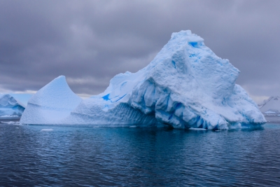
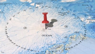
No one owns Antarctica, but the penguins call it home. A frozen landmass that is over four times bigger than India, it has become a bellwether of the climate crisis.

Last year, a large chunk of ice-1.270 sq. km wide-split from the continental shelf causing concern among scientists. Was it due to climate change? Scientists are not sure. But what they know is that the rate of ice loss in Antarctica has tripled since 2012 compared to two decades earlier. Large chunks are splitting regularly from ice shelves, often requiring maps to be redrawn. The warming climate is having an impact on the 6-km-deep ice sheets and the resident penguin population.

Home of penguins

An estimated 12 million penguins live in Antarctica, though it is not their only habitat. Of the 18 species, only five live in Antarctica, including the renowned emperor penguins who march across the frozen tundra in a mating ritual that was featured in the documentary. "March of the Penguins" (Unfortunately, a new report forecasts that the entire population of emperor penguins may disappear by the year 21001)

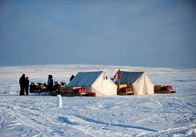
Inspired in part by the movie and a desire to see the impact of climate change, I flew with two friends to Antarctica a few years ago. It was quite an adventure.

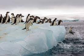
A plane took us from Punta Arenas, Chile, to the Chilean air base on King George Island. As it landed, a group of curious gentoo penguins came out to greet us. They were probably wondering who we were and why we were invading their space! We saw more of their cousins and their colonies as well as elephant seals and leopard seals when we explored the land and the sea over the next few days.

Cause for concern

About 90 per cent of the world's ice and 70 per cent of fresh water is in Antarctica. Some have calculated that if all of Antarctica's ice melted, sea levels would rise 60 to 70 m. drowning all coastal cities. Should we be concerned? Most certainly, as we would want to bequeath a better planet to future generations.

Antarctica is regarded by scientists as the perfect place to do research on flora and fauna, climate and a variety of issues-so there are 70 research stations involving 29 countries. Though there is no native human population, visiting researchers hope to find new organisms or data that could reveal the Earth's climate history and signs of a changing environment.


Living and doing research in a place, where temperatures can dip to minus 90 degrees Celsius and dark winters last six months, can be a challenge in the best of times. But it became a bigger challenge during the pandemic. In December 2020, the Chilean research station reported 36 COVID cases and the affected persons had to be evacuated to their home country.

New research

In 1985, British scientists discovered a hole in the ozone layer above Antarctica, which revealed the damage done to the Earth's atmosphere by manmade chemicals. In 2012, U.S. researchers discovered that Antarctica was melting twice as fast as previously thought. They also found that a warming ocean west of Antarctica would enable the king crab to move from the deep sea to shallower waters, making it a big predator and disrupting the ecosystem.

In 2017, India's polar biologists stumbled upon a species of moss they named Bryumbharatiensis. How had moss survived in this barren landscape? Dr Felix Bast, a member of the Indian research team, observed that the moss is nourished by penguin poop, which contains nitrogen and does not decompose in a frigid climate.

Impact of climate change

Sadly, Antarctica will not remain a winter wonderland for long on account of climate change. A group of scientists led by Stephen Rintoul have presented two stark images of Antarctica by 2070. In Vision 1, assuming global air temperatures rise 2.9 degrees Celsius, they predict sea levels will rise 27 cm, ice sheets will be reduced by 23 per cent and damage to the ecosystem will be most severe. In Vision 2, assuming a 0.9 degrees Celsius temperature rise, sea levels will rise only 6 cm, ice shelf loss will be 8 per cent, and damage to the ecosystem will be less severe. The outcomes will be determined by the climate actions we take in this decade. If global warming remains unchecked, it is quite possible that Antarctica will "be the world's only habitable continent by the end of this century," warns Sir David King, former Chief Scientist to the British government. Will humanity rise to the climate challenge?

Picture Credit : Google