WHAT CAUSES OCEAN CURRENTS?


Currents of water in the world’s oceans and seas are generated by wind and the movement of warm and cold water. Warm currents created by wind flow near the surface of the water and move away from the Equator. Cold water from the poles sinks below the warm water and moves into its place. Warm and cold currents often flow in the same area in different directions. The rotation of the Earth affects some currents by turning them into twisting movements called gyres.


Ocean currents are giant flowing streams of water that continually move through the ocean in a specific prevailing direction. Some currents flow at the ocean's surface (the upper 400 meters) , while some are found much deeper in the ocean. All ocean currents make a system that circulates around the global ocean. The volume of water transported by the global oceanic Conveyor Belt, (more about it later), is equivalent to the flow of about 100 Amazon Rivers or 16 times the flow of all the world’s rivers combined. This enormous potential of current energy could be utilized. Just think about clean, reliable, and inexhaustible "hydro" energy that is embedded in ocean currents!


Some currents carry warm water, typically from the equatorial parts of the ocean toward the poles, while others move cold water - usually from the polar areas toward the Equator.


It is difficult to map an ocean current, as the ocean water is clear and the reflection of light on the water surface does not depend on the velocity or temperature of the floating water. One way to map the ocean currents is by using sea surface temperatures derived from satellite imagery, as on these illustrations. Some surface currents carry water with temperature that may significantly vary from nearby water.


The rotation of the globe and the force of prevailing winds blowing over the ocean result in the flow of the ocean currents. More specifically, the ocean currents are controlled by three major factors: global winds, the Coriolis force, and the shape of the continents and locations of the major islands. The strongest currents are additionally "powered" by the differences in water temperature and salinity, which both result in the differences of water density, and consequently its weight.


The energy that the Earth absorbs from the Sun's radiation is not evenly distributed over the planet's surface, which causes convection, which in turn creates the prevailing winds, and finally, the ocean currents. Atmospheric circulation and ocean currents are the means to transfer heat from the warmest equatorial areas toward the Polar Regions. Clearly, ocean currents move significantly slower than winds, but they hold (first absorb, then release) more heat than the winds that push masses.


It is estimated that 20% of the spatial redistribution of heat on Earth is the effect of flowing ocean currents. Winds account for the remaining 80%.


Picture Credit : Google


HOW MUCH OF THE EARTH IS COVERED BY WATER?


Though the hulk of our planet is made of rock, around 70% of its surface is covered with water. The Earth's seas and oceans account for most of this coverage -- the Pacific Ocean (done covers more than a third of the Earth.


            The Earth is a watery place. But just how much water exists on, in, and above our planet? The oceans hold about 96.5 percent of all Earth's water. Water also exists in the air as water vapor, in rivers and lakes, in icecaps and glaciers in the ground as soil moisture and in aquifers, and even in you and your dog.


Water is never sitting still. Thanks to the water cycle, our planet's water supply is constantly moving from one place to another and from one form to another. Things would get pretty stale without the water cycle!


The vast majority of water on the Earth's surface, over 96 percent, is saline water in the oceans. The freshwater resources, such as water falling from the skies and moving into streams, rivers, lakes, and groundwater, provide people with the water they need every day to live. Water sitting on the surface of the Earth is easy to visualize, and your view of the water cycle might be that rainfall fills up the rivers and lakes. But, the unseen water below our feet is critically important to life, also. How do you account for the flow in rivers after weeks without rain? In fact, how do you account for the water flowing down a driveway on a day when it didn't rain? The answer is that there is more to our water supply than just surface water, there is also plenty of water beneath our feet.


Even though you may only notice water on the Earth's surface, there is much more freshwater stored in the ground than there is in liquid form on the surface. In fact, some of the water you see flowing in rivers comes from seepage of groundwater into river beds. Water from precipitation continually seeps into the ground to recharge aquifers, while at the same time water in the ground continually recharges rivers through seepage.


Humans are happy this happens because we make use of both kinds of water. In the United States in 2010, we used about 275 billion gallons (1,041 billion liters) of surface water per day, and about 79.3 billion gallons (300.2 billion liters) of groundwater per day. Although surface water is used more to supply drinking water and to irrigate crops, groundwater is vital in that it not only helps to keep rivers and lakes full, it also provides water for people in places where visible water is scarce, such as in desert towns of the western United States. Without groundwater, people would be sand-surfing in Palm Springs, California instead of playing golf.


Picture Credit : Google


WHY DO SOME CAVES HAVE STALACTITES AND STALAGMITES?


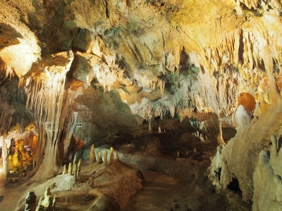
Stalactites and stalagmites can be found in limestone caves. As water drips down through limestone, it dissolves it and leaves behind deposits of a mineral called calcite. This produces distinctive stalactites that hang from the roof of the cave. When the calcite forms in pools of water on the cave floor, deposits grow upwards, forming stalagmites. Where the two features meet, they form columns.


Stalactite and stalagmite, elongated forms of various minerals deposited from solution by slowly dripping water. A stalactite hangs like an icicle from the ceiling or sides of a cavern. A stalagmite appears like an inverted stalactite, rising from the floor of a cavern.


Stalactites hanging from the ceilings of caverns commonly exhibit a central tube or the trace of a former tube whose diameter is that of a drop of water hanging by surface tension. A drop on the tip of a growing stalactite leaves a deposit only around its rim. Downward growth of the rim makes the tube. The simplest stalactite form, therefore, is a thin-walled stone straw, and these fragile forms may reach lengths of 0.5 m (20 inches) or more where air currents have not seriously disturbed the growth. The more common form is a downward-tapering cone and is simply a thickening of the straw type by mineral deposition from a film of water descending the exterior of the pendant.


Stalagmites have thicker proportions and grow up on the bottom of a cavern from the same drip-water source, the mineral from which is deposited after the water droplet falls across the open space in the rock. Not every stalactite has a complementary stalagmite, and many of the latter may have no stalactite above them. Where the paired relation exists, however, continual elongation of one or both may eventually result in a junction and the formation of a column.


The dominant mineral in such deposits is calcite (calcium carbonate), and the largest displays are formed in caves of limestone and dolomite. Other minerals that may be deposited include other carbonates, opal, chalcedony, limonite, and some sulfides.


Picture Credit : Google


HOW DO CAVES FORM?


Caves can form in different ways, depending on the type of landscape in which they are situated. Limestone is a very soft rock, and caves are quite common in limestone areas as it dissolves in rainwater. Caves can be formed out of coastal cliff faces by waves crashing against them, and ice caves may appear where streams of melt water run beneath a glacier. The hardened lava of a volcanic eruption may also leave a hollow beneath, producing a lava cave.


Caves are formed by the dissolution of limestone. Rainwater picks up carbon dioxide from the air and as it percolates through the soil, which turns into a weak acid. This slowly dissolves out the limestone along the joints, bedding planes and fractures, some of which become enlarged enough to form caves.


The largest caves form where water flows onto the limestone from the adjacent impermeable Portishead Formation (Old Red Sandstone), and Avon Group mudstones. The water sinks underground into holes known locally as 'swallets' or 'slockers'. The streams reappear at the base of the limestone outcrop at large springs, for example at Cheddar and Wookey Hole. Over time, the water finds new lower routes leaving some caves high and dry. Some of these have been dug out by cavers.


The dipping Carboniferous limestones have produced a particular style of cave. A typical Mendip swallet cave is developed where a stream sinks underground at the contact between the Avon Group and the Carboniferous Limestone.


Initially the cave descends steeply, often down dip or along joints, via a series of small cascades or pitches. On reaching the water table the passage enters the phreatic, (sub water table) zone, marked by a water-filled section known as a sump. These phreatic passages display a characteristic looping profile as the water flows down a bedding plane, and then ascends up a joint or other fracture to gain higher bedding planes within the limestone en route to the resurgence. As time progresses, the cave will tend towards a more graded even profile.


Erosion at the spring outlet may cause the stream to find a new lower course, leaving the former passage high and dry. In this way a whole series of abandoned former stream courses may lie above the active streamway. For example, Gough's Cave in Cheddar, is a former, abandoned, course of the River Yeo. Detailed studies of these passages can give clues about how the cave evolved over time and former water-table positions. These abandoned passages may become modified by breakdown and collapse, be partially infilled by sediment or stalagmite deposition, or even become reactivated or destroyed at a later date.


Picture Credit : Google


WHAT ARE RIFTS AND CANYONS?


River water does not always carve out wide valleys. In some areas, where there are fairly soft rocks, for instance, very deep, narrow valleys with vertical sides called canyons are formed. In places where continents are drifting apart, very wide rift valleys and flat areas known as plateaux can appear. The Great Rift Valley in Africa is the biggest example of these.


The resistant parts of the canyon walls of the Martian rift complex Valles Marineris have been used to infer an earlier, less eroded reconstruction of the major troughs. The individual canyons were then compared with individual rifts of East Africa. When measured in units of planetary radius, Martian canyons show a distribution of lengths nearly identical to those in Africa, both for individual rifts and for compound rift systems. A common mechanism which scales with planetary radius is suggested. Martian canyons are significantly wider than African rifts. This is consistent with the long-standing idea that rift width is related to crustal thickness: most evidence favors a crust on Mars at least 50% thicker than that of Africa. The overall pattern of the rift systems of Africa and Mars are quite different in that the African systems are composed of numerous small faults with highly variable trend. On Mars the trends are less variable; individual scarps are straighter for longer than on Earth. This is probably due to the difference in tectonic histories of the two planets: the complex history of the Earth and the resulting complicated basement structures influence the development of new rifts. The basement and lithosphere of Mars are inferred to be simple, reflecting a relatively inactive tectonic history prior to the formation of the canyonlands.


Picture Credit : Google


HOW IS A RIVER VALLEY FORMED?


Over time, rainfall has the effect of eroding the land to form valleys and other features. At mountain peaks, the rainwater flows quickly to form narrow gullies. Slowing down as it moves further downhill, the water forms a wide valley.


A valley is an extended depression in the Earth's surface that is usually bounded by hills or mountains and is normally occupied by a river or stream. Since valleys are usually occupied by a river, they can also slope down to an outlet which can be another river, a lake or the ocean.


Valleys are one of the most common landforms on the Earth and they are formed through erosion or the gradual wearing down of the land by wind and water. In river valleys?, for example, the river acts as an erosional agent by grinding down the rock or soil and creating a valley. The shape of valleys varies but they are typically steep-sided canyons or broad plains, however, their form depends on what is eroding it, the slope of the land, the type of rock or soil and the amount of time the land has been eroded.


There are three common types of valleys which include V-shaped valleys, U-shaped valleys, and flat-floored valleys.


V-Shaped Valleys


A V-shaped valley is a narrow valley with steeply sloped sides that appear similar to the letter "V" from a cross-section. They are formed by strong streams, which over time have cut down into the rock through a process called downcutting. These valleys form in mountainous and/or highland areas with streams in their "youthful" stage. At this stage, streams flow rapidly down steep slopes.


An example of a V-shaped valley is the Grand Canyon in the Southwestern United States. After millions of years of erosion, the Colorado River cut through the rock of the Colorado Plateau and formed a steep-sided canyon V-shaped canyon known today as the Grand Canyon.


U-Shaped Valley


A U-shaped valley is a valley with a profile similar to the letter "U." They are characterized by steep sides that curve in at the base of the valley wall. They also have broad, flat valley floors. U-shaped valleys are formed by glacial erosion as massive mountain glaciers moved slowly down mountain slopes during the last glaciation. U-shaped valleys are found in areas with a high elevation and in high latitudes, where the most glaciation has occurred. Large glaciers that have formed in high latitudes are called continental glaciers or ice sheets, while those forming in mountain ranges are called alpine or mountain glaciers.


Due to their large size and weight, glaciers are able to completely alter topography, but it is the alpine glaciers that formed most of the world's U-shaped valleys. This is because they flowed down the pre-existing river or V-shaped valleys during the last glaciation and caused the bottom of the "V" to level out into a "U" shape as the ice eroded the valley walls, resulting in a wider, deeper valley. For this reason, U-shaped valleys are sometimes referred to as glacial troughs.


One of the world's most famous U-shaped valleys is Yosemite Valley in California. It has a broad plain that now consists of the Merced River along with granite walls that were eroded by glaciers during the last glaciation.


Picture Credit : Google


ARE SOME MOUNTAINS OLDER THAN OTHERS?


Mountains form over many millions of years, and due to the continual movement of the Earth's plates, they are still being formed. Young mountain ranges are those that have formed in the last 50 million years or so, such as the Himalayas in Asia. Older mountain ranges, such as the Urals in Russia or the Scottish Highlands, were formed many more millions of years ago and have eroded significantly.


It’s true. Mountains are seriously old. They date back millions and millions of years. As for how they formed, it happened over time. For instance, some mountains formed when volcanoes erupted over and over. The lava that spewed from the volcanoes built up over time. And eventually, this formed a mountain. In other cases, mountains formed when two layers beneath the Earth’s crust moved, collided and pushed against each other. This caused the land to crumple and rise up to form the shape of a mountain.


According to most scientists, the oldest mountain range on Earth is called the Barberton Greenstone Belt and is found in South Africa. It’s estimated that the range is at least 3.2 billion (yes, billion!) years old. As for the youngest mountain on Earth? That title goes to the Himalayas in Asia. It’s thought that this range formed about 40 million years ago. Although that’s not exactly what we’d call young!


If you really want to learn more about mountains, it helps to know the features that make up these land masses. The highest point of a mountain is called the peak or summit. And the bottom of the mountain where the ground begins is known as the base. There’s also the snow line. That’s where ice and snow begin to appear on a mountain. Then there’s the gorge, which is a narrow valley between mountains. And while we’re talking mountains, it’s probably worth mentioning that the name for a long group of mountains is called a range. Some mountain ranges can stretch great distances. For instance, the Rocky Mountains extend all the way from Canada to Mexico. 


Picture Credit : Google


WHERE ARE THE WORLD'S HIGHEST MOUNTAINS?


No fewer than ten of the highest mountains in the world are in the Himalayas. Highest of all is Everest, which lies on the border of Nepal and China. At a height of 8848m (29,028ft), it is almost 2000m (6562ft) higher than the highest mountain outside the Himalayas — Aconcagua in Argentina, South America.


The mountain's height was first determined in 1856. The Great Trigonometric Survey of British India pegged the mountain, known to them as Peak XV, at 29,002 feet (8,840 meters). But those surveyors were at a disadvantage because Nepal would not grant them entry due to concerns that the country would be invaded or annexed. The current accepted elevation was determined by an Indian survey in 1955 and backed up by a 1975 Chinese measurement.


In 1865, Andrew Waugh, the British Surveyor General of India, suggested that the mountain be named after his predecessor in the job, Sir George Everest. The Tibetans had referred to the mountain as "Chomolungma," or Holy Mother, for centuries, but Waugh did not know this because Nepal and Tibet were closed to outsiders.


Mount Everest attracts experienced mountaineers as well as less-seasoned climbers who typically enlist guides known as sherpas. Climbing more than 8,000 feet is no easy feat. Altitude sickness, weather and wind are the major roadblocks to making the summit for most climbers. More than 5,000 people have climbed Everest and 219 have died trying. About 77 percent of those ascents have been accomplished since 2000. In 2007, a record number of 633 ascents were recorded.


Mount Everest has two main climbing routes, the southeast ridge from Nepal and the north ridge from Tibet. Today, the southeast ridge route, which is technically easier, is more frequently used.


Picture Credit : Google


WHAT ARE THE DIFFERENT TYPES OF MOUNTAIN?


There are four basic kinds of mountains:


  1. Fold Mountains (Folded Mountains)

  2. Fault-block Mountains (Block Mountains)

  3. Dome Mountains

  4. Volcanic Mountains


These different types of mountain names not only distinguish the physical characteristics of the mountains, but also how they were formed.


Fold Mountains


Fold mountains are the most common type of mountain. The world’s largest mountain ranges are fold mountains. These ranges were formed over millions of years.


Fold mountains are formed when two plates collide head on, and their edges crumbled, much the same way as a piece of paper folds when pushed together.


The upward folds are known as anticlines, and the downward folds are synclines.


Examples of fold mountains include:


  • Himalayan Mountains in Asia

  • the Alps in Europe

  • the Andes in South America

  • the Rockies in North America

  • the Urals in Russia


The Himalayan Mountains were formed when India crashed into Asia and pushed up the tallest mountain range on the continents.


In South America, the Andes Mountains were formed by the collision of the South American continental plate and the oceanic

Pacific plate.


 Fault-block Mountains


These mountains form when faults or cracks in the earth's crust force some materials or blocks of rock up and others down.


Instead of the earth folding over, the earth's crust fractures (pulls apart). It breaks up into blocks or chunks. Sometimes these blocks of rock move up and down, as they move apart and blocks of rock end up being stacked on one another.


Often fault-block mountains have a steep front side and a sloping back side.


Examples of fault-block mountains include:


  • the Sierra Nevada mountains in North America

  • the Harz Mountains in Germany


 Dome Mountains


Dome mountains are the result of a great amount of melted rock (magma) pushing its way up under the earth crust. Without actually erupting onto the surface, the magma pushes up overlaying rock layers. At some point, the magma cools and forms hardened rock. The uplifted area created by rising magma is called a dome because of looking like the top half of a sphere (ball). The rock layers over the hardened magma are warped upward to form the dome. But the rock layers of the surrounding area remain flat.


As the dome is higher than its surroundings, erosion by wind and rain occurs from the top. This results in a circular mountain range. Domes that have been worn away in places form many separate peaks called Dome Mountains.


Volcanic Mountains


As the name suggests, volcanic mountains are formed by volcanoes.


Volcanic Mountains are formed when molten rock (magma) deep within the earth, erupts, and piles upon the surface. Magna is called lava when it breaks through the earth's crust. When the ash and lava cools, it builds a cone of rock. Rock and lava pile up, layer on top of layer.


Examples of volcanic mountains include:


  • Mount St. Helens in North America

  • Mount Pinatubo in the Philippines

  • Mount Kea and Mount Loa in Hawaii


Picture Credit : Google


WHAT CAUSES AN AVALANCHE?


Avalanches are huge masses of snow that suddenly crash down a mountainside. They are caused by a combination of heavy snow and a sudden rise in temperature. Avalanches can be up to 1 km (0.6 miles) across and generate winds of up to 300km/h (185mph). Their effects on towns and local populations can be devastating.


Avalanches can be caused by many things. Some of them are natural. For example, new snow or rain can cause built up snow to loosen and fall down the side of a mountain. Earthquakes and the movement of animals have also been known to cause avalanches.


Artificial triggers can also cause avalanches. For example, snowmobiles, skiers, gunshots, and explosives have all been known to cause avalanches. Avalanches usually occur during the winter and spring, when snowfall is greatest. As they are dangerous to any living beings in their path, avalanches have destroyed forests, roads, railroads and even entire towns.


Warning signs exist that allow experts to predict — and often prevent — avalanches from occurring. When over a foot of fresh snow falls, experts know to be on the lookout for avalanches. Explosives can be used in places with massive snow buildups to trigger smaller avalanches that don't pose a danger to persons or property.


When deadly avalanches do occur, the moving snow can quickly reach over 80 miles per hour. Skiers caught in such avalanches can be buried under dozens of feet of snow. While it's possible to dig out of such avalanches, not all are able to escape.


If you get tossed about by an avalanche and find yourself buried under many feet of snow, you might not have a true sense of which way is up and which way is down. Some avalanche victims have tried to dig their way out, only to find that they were upside down and digging themselves farther under the snow rather than to the top!


Experts suggest that people caught in an avalanche try to “swim" to the top of the moving snow to stay close to the surface. Once the avalanche stops, do your best to dig around you to create a space for air, so you can breathe easier. Then, do your best to figure out which way is up and dig in that direction to reach the surface and signal rescuers.


Picture Credit : Google


HOW ARE MOUNTAINS FORMED?


Mountain ranges make up some of the world's most impressive landscapes. Like earthquakes and volcanoes, they are formed as a consequence of the activity of the Earth's tectonic plates. Where the plates push up against one another, the Earth's crust buckles and folds, resulting in ranges of Rocky Mountains. Volcanoes also make up some of the world's greatest mountains.


There are a few ways that mountains can form. One thing these methods have in common is that they all take millions of years!


Most mountains formed from Earth’s tectonic plates smashing together. Below the ground, Earth’s crust is made up of multiple tectonic plates. They’ve been moving around since the beginning of time. And they still move today as a result of geologic activity below the surface. On average, these plates move at a rate of about one to two inches each year.


When two tectonic plates come together, their edges can crumple. Think of what happens to an aluminum can when you crush it. It’s a bit like that! The result of these tectonic plates crumpling is huge slabs of rock being pushed up into the air. What are those called? Mountains, of course! Specifically, these are called “fold mountains.” 


For example, the tectonic plates that lie underneath India and Asia crashed into each other over 25 million years ago. What happened? The Himalayas, including Mount Everest, formed. And they’re still pushing against each other. That means the Himalayas are still growing even today!


Sometimes, instead of crashing together, two tectonic plates grind against each other. Occasionally, this results in one plate lifting up and tilting over. The result? A fault-block mountain range! One example is the Sierra Nevada mountain range in California.


Other times, a unique type of mountain is made when one plate is pushed below the other, pushing magma to the surface. This is how volcanoes, like Mount Fuji, are made. Volcanic activity below Earth’s surface can also result in new mountains when magma is pushed up toward the surface. When that happens, it cools and forms hard rock. The result is dome mountains. 


Mountains can also form by way of erosion. In an area with a high plateau, rivers and streams can carve away stone in the form of deep channels. Over millions of years, what is left is a mountain between deep river valleys!


Picture Credit : Google


WHAT CAN SCIENTISTS DISCOVER IN THE POLAR REGIONS?


Scientists who study glaciers and polar ice are called glaciologists. There are permanent research stations based in Polar Regions, manned by glaciologists who can discover a great deal about the Earth. Working in laboratories dug out of the ice, they investigate layers of ice that contain gases and substances from climatic conditions of the past. Ice cores are also drilled from the ice and taken back to laboratories for detailed testing.


Earth has two polar regions – the Arctic and the Antarctic – and each is considerably larger than the lower 48 United States.  The most distinctive features of both polar regions are cold climate and abundant snow and ice, caused by the extreme annual variation of sunlight.  At the North and South Poles, the sun is below the horizon for six consecutive months, then above the horizon for the next six months.  Poleward of the Arctic and Antarctic Circles (currently approximately 66º 34’ North and South) there is at least one 24-hour period each year when the sun is continuously above the horizon, and one when it is continuously below it.  These circles are sometimes used to define the boundaries of the polar regions. Other definitions are poleward of treeline and poleward of the line where the average surface air temperature exceeds 10º C in the warmest month of the year.


The central Arctic is an ocean with depths exceeding 4000 meters, topped by sea-ice (frozen seawater) of average thickness 3 meters.  The sea-ice moves continually in response to winds and ocean currents, with typical speeds of 5-10 km per day.  Tundra, a treeless land of low growing vegetation, covers the northern fringes of the surrounding continents.


The central Antarctic is a continent, covered by a massive sheet of glacial ice (formed by accumulation of snowfall) of average thickness 2000 meters.  The glacial ice moves slowly downhill in response to gravity, with horizontal speed on the order of 10m per year.  The vast Southern Ocean surrounds the continent, and supports a canopy of sea-ice thinner on average than its Arctic counterpart.


People settled in the Arctic thousands of years ago, and when explorers from lower latitude reached the Arctic, they found established cultures based on subsistence hunting.  In the Antarctic the human presence is limited primarily to tourists and scientists who stay for a season or a year.


The polar regions are home to a surprising variety of animals and plants.  Each species has adapted to the prolonged periods of sunlight and darkness, the low temperature, and the snow and ice.  In the central Arctic, polar bears and Arctic foxes roam the surface of the pack ice.  In Antarctica penguins inhabit the perimeter of the continent, feeding in the coastal waters and rearing their young on the ice surface.  Marine mammals such as whales and seals abound in the Arctic and the Antarctic, though there are differences of species, for example the walrus lives only in the Arctic, while the leopard seal is an Antarctic resident.  Caribou, musk ox, grizzly bears and lemmings range over the Arctic tundra.


Polar science is a broad term encompassing the scientific study of any aspect of the polar regions.  Science treats phenomena as consequences of general laws, which may be refuted or not refuted by following the scientific method of observation, hypothesis, experiment and measurement.  Polar science has its disciplines, sub-disciplines and inter-disciplines, e.g. physics, chemistry, biology, anthropology, sociology, oceanography, meteorology, biogeochemistry, botany, zoology, and ecology.  A large fraction of polar science fits well under the heading “environmental science”, which sometimes is taken to mean the study of everything non-human that interacts with humans.  Thus defined, polar science encompasses much.  It applies equally to the zoologist fastening a tracking device to a polar bear on the Arctic pack ice, as to the theoretical physicist working on mathematical expressions of thermodynamic principles to predict how a gas migrates through the glacial ice sheet on Antarctica.  The last 30 years or so have seen a notable increase in research concerned with long term, progressive changes in the polar regions.  This increase has been spurred by theories of climate change as a response to increased concentrations of greenhouse gases in the atmosphere, and by observations of large scale environmental change, especially in the Arctic.


Picture Credit : Google


DOES THE SEA EVER FREEZE?


When the temperature of the sea dips below —1.9°C (28°F), it can freeze. This happens off the Antarctic coast and other glaciated regions. The whole of the North Pole is in fact frozen sea that is never more than a few metres thick. Sea ice is often referred to as pack ice.


If the temperature is cold enough, ocean water does freeze. The polar ice cap at earth's North Pole is a giant slab of frozen ocean water. At earth's South Pole, the land mass constituting Antarctica complicates the situation, so most of the ice there is compacted snow. Over cold regions such as Antarctica, Greenland, and Canada, the fresh water in the air freezes to snow and falls onto the land without a melting season to get rid of it. Over time, this snow builds up and compacts into an ice mass known as a glacier. Gravity slowly pulls the glacier downhill until it reaches out onto the ocean, forming an ice shelf. The ocean-bound edge of the ice shelf slowly crumbles into icebergs which float off on their own path. For this reason, glaciers, ice shelves, and icebergs are all thick sheets of frozen fresh water and not frozen ocean water. In contrast, when ocean water freezes, it forms a thin flat layer known as sea ice or pack ice. Sea ice has long been the enemy of ships seeking an open route through cold waters, but modern ice breaker ships have no problem breaking a path through the fields of frozen ocean.


Despite the fact that the oceans do freeze when the temperature is cold enough, ocean water does indeed stay liquid under much colder weather than one would first expect. For instance, go to the beach on a winter day and you may be surprised to find that the ocean is still liquid despite the snow and ice on the ground being frozen. There are four main factors that keep the ocean in a liquid state much more than may be expected, as described in the textbook Essentials of Oceanography by Tom Garrison.


Salt

The high concentration of salt in ocean water lowers its freezing point from 32° F (0° C) to 28° F (-2° C). As a result, the ambient temperature must reach a lower point in order to freeze the ocean than to freeze freshwater lakes. This freezing-point depression effect is the same reason we throw salt on icy sidewalks in the winter. The salt lowers the freezing point of the ice below the ambient temperature and it melts. Note that if the ambient temperature is lower than 28° F (-2° C), the ocean water would be ice if this were the only effect involved. Such is not the case, so there must be other effects involved.


Ocean currents


The gravitational pull of the moon, earth's spinning motion, and thermal convection combine to create large-scale flows of ocean water known as ocean currents. This constant motion of the ocean water helps keep the water molecules from freezing into the somewhat stationary state of ice crystals. More significantly, the ocean currents continuously pump warm water from the equatorial regions to the colder ocean regions.


High volume


The larger the volume of water, the more heat has to be removed in order to freeze it. A teaspoon of water placed in the freezer will become completely solid long before a gallon jug of water. More accurately, it is the surface-area to volume ratio for a given external temperature that determines the rate of heat loss and therefore the speed of freezing. Because the heat must be lost through its surface, a small shallow puddle with a large surface will freeze quicker than a deep lake. The immense volume and depth of the oceans keeps them from freezing too quickly, thereby allowing the heating mechanisms to have a larger effect.


Earth's internal heating


As miners are well aware, the earth gets hotter and not colder as you dig straight down, despite the fact that you are getting farther away from the warm sunlight. The reason for this is that the earth has its own internal heat source which is driven primarily by the nuclear decay of elements inside earth's mantle. The earth's internal heat is most evident when lava flows and hot springs poke through the surface. Because earth's insulating crust is much thinner under the oceans than under the continents, most of the earth's internal heat escapes into the oceans. Although the temperature of the air at an ocean's surface may be freezing, the temperature of the water deep in the ocean is significantly warmer due to internal heating.


This combination of salt, ocean currents, high volume, and internal heating keeps most of the ocean in liquid form even during cold winters.


Picture Credit : Google


HOW ARE ICEBERGS FORMED?


Icebergs are formed from freshwater ice brought to the sea by glaciers, or when chunks are broken off an ice cap due to the effect of the tide and waves. This effect is known as calving. Icebergs contain large amounts of rock fragments that make them heavy, and they sit low in the sea. Once an iceberg has broken off, its movement depends upon the wind and sea currents.


Iceberg, floating mass of freshwater ice that has broken from the seaward end of either a glacier or an ice shelf. Icebergs are found in the oceans surrounding Antarctica, in the seas of the Arctic and subarctic, in Arctic fjords, and in lakes fed by glaciers.


Icebergs of the Antarctic calve from floating ice shelves and are a magnificent sight, forming huge, flat “tabular” structures. A typical newly calved iceberg of this type has a diameter that ranges from several kilometres to tens of kilometres, a thickness of 200–400 metres (660–1,320 feet), and a freeboard, or the height of the “berg” above the waterline, of 30–50 metres (100–160 feet). The mass of a tabular iceberg is typically several billion tons. Floating ice shelves are a continuation of the flowing mass of ice that makes up the continental ice sheet. Floating ice shelves fringe about 30 percent of Antarctica’s coastline, and the transition area where floating ice meets ice that sits directly on bedrock is known as the grounding line. Under the pressure of the ice flowing outward from the centre of the continent, the ice in these shelves moves seaward at 0.3–2.6 km (0.2–1.6 miles) per year. The exposed seaward front of the ice shelf experiences stresses from subshelf currents, tides, and ocean swell in the summer and moving pack ice during the winter. Since the shelf normally possesses cracks and crevasses, it will eventually fracture to yield freely floating icebergs. Some minor ice shelves generate large iceberg volumes because of their rapid velocity; the small Amery Ice Shelf, for instance, produces 31 cubic km (about 7 cubic miles) of icebergs per year as it drains about 12 percent of the east Antarctic Ice Sheet.


Most Arctic icebergs originate from the fast-flowing glaciers that descend from the Greenland Ice Sheet. Many glaciers are funneled through gaps in the chain of coastal mountains. The irregularity of the bedrock and valley wall topography both slows and accelerates the progress of glaciers. These stresses cause crevasses to form, which are then incorporated into the structure of the icebergs. Arctic bergs tend to be smaller and more randomly shaped than Antarctic bergs and also contain inherent planes of weakness, which can easily lead to further fracturing. If their draft exceeds the water depth of the submerged sill at the mouth of the fjord, newly calved bergs may stay trapped for long periods in their fjords of origin. Such an iceberg will change shape, especially in summer as the water in the fjord warms, through the action of differential melt rates occurring at different depths. Such variations in melting can affect iceberg stability and cause the berg to capsize. Examining the profiles of capsized bergs can help researchers detect the variation of summer temperature occurring at different depths within the fjord. In addition, the upper surfaces of capsized bergs may be covered by small scalloped indentations that are by-products of small convection cells that form when ice melts at the ice-water interface.


Picture Credit : Google


HOW DOES AN ICE CAP FORM?


An ice cap is a glacier, a thick layer of ice and snow, that covers fewer than 50,000 square kilometers (19,000 square miles). Glacial ice covering more than 50,000 square kilometers (19,000 square miles) is called an ice sheet.


An interconnected series of ice caps and glaciers is called an ice field. Ice caps and ice fields are often punctuated by nunataks. Nunataks are areas where just the summits of mountains penetrate the ice.


Ice caps form like other glaciers. Snow accumulates year after year, then melts. The slightly melted snow gets harder and compresses. It slowly changes texture from fluffy powder to a block of hard, round ice pellets. New snow falls and buries the grainy snow. The hard snow underneath gets even denser. It is known as firn.


As years go by, layers of firn build on top of each other. When the ice grows thick enough—about 50 meters (165 feet)—the firn grains fuse into a huge mass of solid ice. At this point, the glacier begins to move under its own weight.


Ice caps tend to be slightly dome-shaped and spread out from their center. They behave plastically, or like a liquid. An ice sheet flows, oozes, and slides over uneven surfaces until it covers everything in its path, including entire valleys, mountains, and plains. Ice caps and ice fields exist all over the world. Ice caps in high-latitude regions are often called polar ice caps. Polar ice caps are made of different materials on different planets. Earth’s polar ice caps are mostly water-based ice. On Mars, polar ice caps are a combination of water ice and solid carbon dioxide.


Many indigenous people have adapted to life around ice caps. The Yupik people of Siberia live in coastal communities along the Chukchi Peninsula, Russia, and St. Lawrence Island, in the U.S. state of Alaska. They rely primarily on marine life to supply food and material goods, however. Seaweeds, walruses, bowhead whales, and fish provide food staples as well as material for dwellings and transportation such as sleds and kayaks.


Northern Europe is home to many ice caps. Vatnajökull, Iceland, is an ice cap that covers more than 8% of the island nation. Austfonna, in the Svalbard archipelago of Norway, is the largest of many ice caps in Scandinavia. The largest ice cap in the world is probably the Severny Island ice cap, part of the Novaya Zemlya archipelago in the Russian Arctic.


Ice caps and ice fields are found far beyond polar regions, however. Mountain ranges, such as the Himalayas, Rockies, Andes, and the Southern Alps of New Zealand are all home to many ice caps and ice fields.


Mount Kilimanjaro, Tanzania, the tallest mountain in Africa, used to have enormous ice caps on its summit. Today, the Furtwangler glacier is the mountain's only remaining ice cap, at 60,000 square kilometers (23,166 square miles). The Furtwangler glacier is melting at a very rapid pace, however, and Africa may lose its only remaining ice cap.


Picture Credit : Google