The Zamberi river is situated on the border of which two countries?


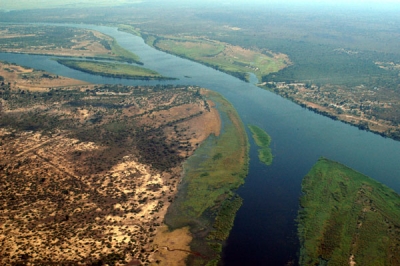
The 2,574-kilometre-long river (1,599 mi) arises in Zambia and flows through eastern Angola, along the north-eastern border of Namibia and the northern border of Botswana, then along the border between Zambia and Zimbabwe to Mozambique, where it crosses the country to empty into the Indian Ocean.


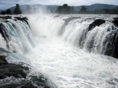
By far the most notable feature of the Zambezi River is the mighty Victoria Falls – one of the Seven Natural Wonders of the World and World Heritage Site. Not to be disregarded, other well-known falls over which the river cascades are the Chavuma Falls in north-west Zambia, and widely inaccessible Ngonye Falls in western Zambia.


The Kariba Dam (or Lake Kariba) in Zimbabwe, and the Cahora Bassa Dam in Mozambique are both man-made dams constructed to provide hydroelectic power to Zambia and Zimbabwe, and Mozambique and South Africa respectively. 200km from Victoria Falls, Kariba is the world largest man-made lake – 226km long and up to 40km in several places. Cahora Bassa, on the other hand, is an arch dam with a length of 171m and a maximum width of 303m.


Due to the fact that the Zambezi River runs through many game reserves and national parks, it provides sustenance to a diverse array of game, birdlife and fish species. Wildlife to be spotted on a game drive along its banks, or a cruise within its waters include elephant, hippos, crocodiles, water buck, buffalo, zebras, and even lion.


Picture Credit : Google


Why is Hogenakkal named so?


The name Hogenakkal is derived from Kannada words hoge, meaning “smoke” and kal meaning “rock,” because the mist created when the water lands at the bottom of the falls makes it look as if the rocks are smoking.


In the western part of Tamil Nadu in India, the Kaveri River tumbles over rocks to create Hogenakkal Falls. Sometimes called the “Niagara Falls of India,” Hogenakkal Falls is dwarfed in size and strength by the Niagara, but it offers an impressive view nonetheless. The Hogenakkal Falls are formed where the river cuts through the rocky terrain on the border between the two states. The falls are made up of a number of individual waterfalls, which range from about 15 feet to 65 feet tall. 


This place has many waterfalls on the river cauvery. Hogenakkal is a hamlet situated in Tamil Nadu bordering Karnataka.


The 15 km descent from Pennagaram to Hogenakkal snakes through very interesting terrain. In these lands, one can see villages with lush fields of mulberry, fodder for busy silkworms, and the broad-leaved though often scraggy castor. On the outskirts of the rural settlements en route are their fascinating guardian deities, often referred to as Aiyanars. Made of terracotta or plastered brick, these giant figures are brightly colored and generally depict fearsome and mustachioed warriors. But exceptions to this excessively macho rule are also seen at some places.


Picture Credit : Google


In which river does Jog Falls originate?


Jog Falls is a waterfall on the Sharavati river located in the Western Ghats in Siddapur taluk of Uttara Kannada district and its viewpoint is in Sagara taluk, Shimoga district. It is the second highest plunge waterfall in India The Jog Falls are located 18 miles (29 km) upstream from Honavar at the river’s mouth on the Arabian Sea. As it plunges 830 feet (253 metres) into a chasm, the river splits into four cascades known as the Raja, or Horseshoe; Roarer; Rocket; and Ranee (“Queen”), or La Dame Blanche (“The White Lady”). A leading scenic attraction, the falls can be observed from bungalows on either bank of the river. A large hydropower project has been developed at Jog, downstream.


Many smaller waterfalls make an appearance in this area. Even if the main waterfall is completely hidden by mist, which does occur, you are likely to catch a glimpse of the other seasonal waterfalls. The nearby district of Uttara Kannada has plenty of waterfalls too. Sharavathi Valley Viewpoint, Linganamakki Dam, and Muppane backwaters are a few other attractions near Jog Falls. The green paddy fields, tree canopies, and undulating terrain in and around Jog provide an experience which no movie can recreate.


Picture Credit : Google


Why is the Angel Falls named so?


The waterfall has been known as the Angel Falls since the mid-20th century; they are named after Jimmie Angel, a US aviator, who was the first person to fly over the falls. Angel's ashes were scattered over the falls on 2 July 1960.


The common Spanish name Salto Ángel derives from his surname. In 2009, President Hugo Chávez announced his intention to change the name to the purported original indigenous Pemon term ("Kerepakupai Vená", meaning "waterfall of the deepest place"), on the grounds that the nation's most famous landmark should bear an indigenous name. Explaining the name change, Chávez was reported to have said, "This is ours, long before Angel ever arrived there ... this is indigenous land." However, he later said that he would not decree the change of name, but only was defending the use of Kerepakupai Vená.


Picture Credit : Google


In which country will you find the Angel Falls – the highest waterfall in the country?


Angel Falls, Spanish Salto Ángel, also called Salto Churún Merú, waterfall in the Guiana Highlands in Bolívar state, southeastern Venezuela, on the Churún River, a tributary of the Caroní, 160 miles (260 km) southeast of Ciudad Bolívar. Angel Falls in Venezuela is the world's tallest waterfall, with a total height of 3212 feet (979 meters). This total height includes a single uninterrupted drop of 2648 feet (807 meters), plus 564 feet (172 meters) of steep cascades and smaller drops downstream from the main falls.


Angel Falls was named for James Angel, an American pilot, who in 1933 was the first aviator to fly over the falls. Within a few years, Angel's story of a "mile-high waterfall" had been widely publicized through stories and trivia items in popular media. This occurred before the height of the falls was properly measured and before the name Angel Falls was in popular use


Angel falls has been in its current location for thousands of years. It will remain there until gravity pulls another block of the highly fractured sandstone away from the mountain. The block will fall to the ground and explode into a catastrophic rain of rock. The river will flow without interruption, but the position of the waterfall will change.


Picture Credit : Google