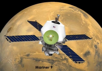
Did Mars have liquid water in the past?

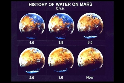
Looking at the photographs of the dry and dusty Mars, would you believe that billions of years ago the planet had enough water to cover about one-fifth of its surface? Scientists say that the Red Planet once used to have rivers, lakes and vast oceans as well! Back then, Mars may have had a thicker atmosphere which made it a warmer and wetter planet than it is today.

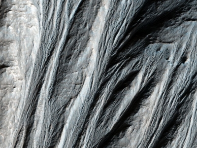
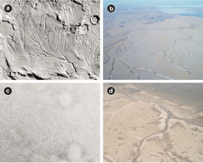
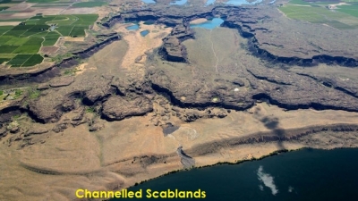
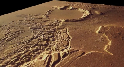
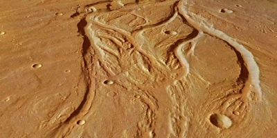
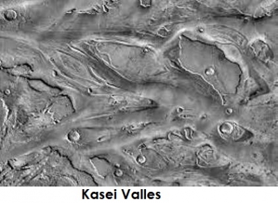
Evidence of Mars’ “watery” past can be found on its surface itself. Certain minerals found in Martian rocks could have formed only in places where water was present. The Martian outflow channels and valley networks point to a time when liquid water used to flood or flow across the Martian surface. Lake beds with tell-tale delta formations have also been reported. Even Martian meteorites found on the Earth show that they were exposed to water on their parent planet!

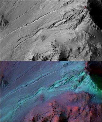
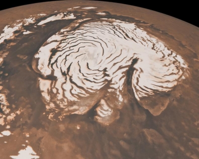
Today, the thin atmosphere of Mars would cause any liquid water on the surface to evaporate. But still water exists in the frozen form as polar ice caps, and potentially beneath the Martian surface. Scientists have also found dark streaks on steep slopes, called Recurring Slope Lineae, or RSL, that were believed to be a mixture of soil and highly concentrated salt water flowing down the Martian slopes. (But some scientists argue that they may just be streams of sand and dust.)

Picture Credit : Google

What are gullies?

On photographs gullies look like little wrinkles on the surface of Mars. But they are actually channels that run for hundreds of metres!

Called gullies, because of their similarity with the gullies seen on the Earth, they are found on both the northern and southern hemispheres of Mars, but are more common on the southern side. They are seen on steep slopes, like those inside craters, mostly on the sides that face the nearest pole. Looking at the near absence of craters in gullies, scientists say they may be very young formations!

Gullies usually have an hourglass shape - starting with “alcoves” (branched, root-like formations made up of smaller grooves) at the top of the slope that merge into a single channel, and ending in a fan-shaped deposit of debris called “apron” at the bottom. Smaller forms of gullies, called linear dune gullies, are found on the slopes of Martian sand dunes.

Though the grooves they cut are long, their alcoves are very small, and they may not even have aprons. Instead, they have raised banks known as levees on either side of their channels.

Picture Credit : Google

How were gullies formed on Mars?

When scientists first discovered gullies on Mars, the news generated a lot of excitement. Similar features on the Earth are created by flowing water, and so Martian gullies seemed to indicate the presence of liquid water on the planet!

Initially, all evidence seemed to point to just that - water that might have come from the melting of glaciers or snow packs during summers, from underground stores of water (called aquifers), or from the thawing of ice trapped in the frozen Martian ground. This liquid water might have eroded the ground as it flowed down the slopes, carving out the gullies we see today, and deposited debris, collected along the way, in the gully aprons at the bottom of the slope.

Later on, scientists studying the images of linear dune gullies taken by the U.S. National Aeronautics and Space Administration’s (NASA) Mars Reconnaissance Orbiter noticed something peculiar - the gullies seemed to form during spring-time. This could have been because they were carved by chunks of dry ice, not water! Scientists say that during Martian winters, a layer of carbon dioxide frost forms over the upper reaches of the gullies. With the arrival of spring, blocks break off from this sheet of dry ice, slide down the dune slopes and create the grooves we call linear dune gullies!

Picture Credit : Google

What do we know about the valley networks on Mars?

A branching network of grooves that look like the river drainage basins on the Earth — who would have thought we would see them on Mars? These are the valley networks, found mainly in the southern highlands region of Mars.

Martian valley networks are typically made up of narrow channels that are a couple of hundred kilometres long, one to five kilometres wide, and 50 to 200 metres deep, even though some may be longer. Like that of a river on the Earth, their cross sections are initially V-shaped, and gradually change to a U-shaped or flat-bottomed form towards the lower ends of the channel. Some of them also seem to carry evidence of flowing water.

The networks are made up of small channels that merge into bigger tributaries over and over until they join to form a single stream. This gives a valley network the appearance of the roots of a tree!

Scientists used to say that the Martian valley networks may have formed billions of years ago when liquid water used to flow across the Martian surface. But some argued that they may also be the products of tectonic activity, or other types of erosion, such as by wind, glaciers, or lava.

Most recent reports support the theory that they were carved by water seeping under glaciers that once used to cover the southern highlands!

Picture Credit : Google

What do scientists say about the origin of valley networks?

Based on the impact craters found in and around these valley networks, scientists say that a majority of the Martian valley networks were formed around 3.7 billion years ago or earlier. A few are relatively young too - evidence suggests that they may have formed about three billion years ago. But there is still a lot of confusion regarding how exactly they were created! There are mainly three theories.

The first is that rain- or snow-fed streams of liquid water once used to flow across the Martian terrain creating valley networks that look very similar to the ones we have on the Earth. For this, Mars had to be a warmer and wetter place than it is now, with a thicker, carbon dioxide-rich atmosphere. But looking at the climate of Mars today (and many other factors), scientists are unable to fully explain how this could be.

The second is that these channels were created by the flow of groundwater beneath the surface. This process, known as “sapping,” may have happened when the cold Martian ground got heated by volcanic or impact events. The third theory is that the water that carved at least some of the valley networks on Mars, did not flow in the open, but under glaciers which protected it from getting frozen.

Picture Credit : Google

How were outflow channels formed?

From glacial erosion to the flow of lava, from mudslides to floods, many theories have been proposed to explain the formation of outflow channels on Mars. But after studying the size and shape of the channels, scientists say that they were probably created by huge and sudden floods known as “outburst floods”. Why? Because, our Earth too has had its share of massive flooding events in the past even though they never were on the scale of what seems to have happened on Mars.

Channelled Scablands in the state of Washington, U.S.A, is said to have formed in a similar manner thousands of years ago when an ice dam holding back a glacial lake burst. It repeated over 40 times creating the Scablands we see today with its dry waterfalls, giant ripple marks and streamlined islands. These are flow features similar to the ones found on the beds of Martian outflow channels!

Scientists say that the outburst floods that created outflow channels on Mars may have been triggered by volcanic explosions or impact events. When they fractured the ground, large stores of liquid water trapped underground beneath layers of ice were released. Rather like a Martian fizzy drink can being popped open! As water rushed out, it must have eroded the sides of the cracks, widening them further, and creating the canyons we see on Mars today.

Picture Credit : Google

What is Kasei Valles?

With a length of about 1,580 kilometres, a width of up to 480 kilometres, and (at certain locations) a depth of two to three kilometres, Kasei Valles is one of the largest outflow channels on Mars. In comparison, the famous Grand Canyon in Arizona, USA (446 kilometres long, up to 29 kilometres wide, and up to1.9 kilometres deep) seems tiny!

Following the general way in which Martian outflow channels are named, Kasei Valles is also named after the Red Planet Kasei means “Mars” in Japanese, and Valles means “valley” in Latin. It is located on the north of Valles Marineris, the largest canyon system on Mars. It starts from a chasma (a deep, steep-sided depression) called Echus Chasma, runs northwards for a while before bending east and ending at Chryse Planitia, a circular smooth plain lying to the east of the Tharsis bulge. Scientists say intense volcanic activity in the Tharsis region around three billion years ago ripped up Echus Chasma, releasing groundwater, and causing outburst floods that created Kasei Valles.

If you look at the images of Kasei Valles, you can see that it splits into two channels that rejoin before reaching Chryse Planitia. The landmass between them is called Sacra Mensa. Kasei Valles also has a 100-kilometre wide impact crater, called Sharonov, and huge dry waterfalls that are 400 to 500 metres high!

Picture Credit : Google

How do we classify Martian channels?

When scientists started looking closely at the photographs of Martian channels, they saw that the channel layouts showed certain unique characteristics that said a lot about how liquid water used to flow through the channels. These landmasses are called “flow features.” They give scientists critical information about how and when the channels were created and shaped. Some of them are streamlined islands (landmasses in the shape of tear drops formed when large rocks or craters with ejecta around them stand in the way of floods), terraces on the sides of the channel, smaller grooves formed within the channel bed, dry waterfalls (ledges within the channel that are also called cataracts), meanders (winding curves), and deltas - features very similar to those found on the Earth’s river beds too!

Martian channels are divided into three - outflow channels, valley networks and gullies - based on their dimensions, and the flow features found in them. Mars also has lava channels created by the flow of, you guessed it, lava!

Even though they may have many characteristics in common with the water-made channels, they are not put under the same group because of the obvious differences in the way they were created. Of the three Martian channels, outflow channels are the biggest and the widest, and gullies are the smallest.

Picture Credit : Google

What are the specialities of Martian outflow channels?

The outflow channels of Mars are huge! As the biggest of the Martian water-eroded channels, they stretch over several hundreds of kilometres, are ten to one-hundred kilometres wide, and are often at least a kilometre deep.

The Kasei Valles, one of the largest outflow channels on the planet, is itself about 1,580 kilometres long, and up to 480 kilometres wide. It may be two to three kilometres deep at certain locations. More than twenty outflow channels have been identified and named by scientists, and most of them are concentrated around major volcanic plains of Mars.

However, it is not their massive size alone that differentiates outflow channels from valley networks and gullies (the other Martian channel types) but also in their structure. The beds of these channels have streamlined islands, massive cataracts and terraces, and many other flow features typically associated with heavy flooding events.

Another speciality of outflow channels is that they are ancient formations! After studying the number of impact craters on their surface, scientists found that some of the oldest outflow channels on Mars may have formed as early as around 3.7 billion years ago. There are also certain other channels in the Elysium and Amazonis areas of Mars that are very old.

Picture Credit : Google

Are the channels on Mars real?

By mid-1900s the Martian-canal confusion had cleared completely, and scientists were convinced that Mars was a dry planet. Photographs taken by the U.S. National Aeronautics and Space Administration’s (NASA) Mariner 4 spacecraft in 1965 and other Mars missions after that had played a huge role in it. That was why everyone was puzzled when about a decade later, in 1972; NASA’s Mariner 9 sent back images of a Martian surface lined with grooves! These were no Martian-made canals like Lowell had predicted, or straight, crisscrossing canali like the ones Schiaparelli had sketched on his maps. They were winding channels carved into the surface of Mars, kilometres long, and very similar to the river-made features we see on the Earth, except that they were completely dry!

It clearly looked as if flowing water had created such terrains but Mars had no liquid water! In fact, its atmosphere is so thin and dry that any water poured on its surface will immediately freeze or evaporate. Gradually, as more and more evidence of its past was discovered, scientists understood that Mars might have been quite a different planet millions of years ago - with a denser atmosphere, it might have been warmer and wetter than it is today. This justifies the possibility that the Martian channels may have been created by floods!

Picture Credit : Google

What was the best thing that came out of Lowell’s obsession over Martian canals?

During the years he spent studying Mars and its “system of canals,” the American astronomer, Percival Lowell, popularized the idea of the presence of intelligent life on Mars through newspapers and his books Mars (1895), Mars and its Canals (1906), and Mars as the Abode of Life (1908). Even though his theories were ultimately proven false, Lowell made great contributions to the field of astronomy. The Lowell Observatory he established in Arizona, U.S.A, in 1894 is one among them.

Using the 24-inch refracting telescope installed in his observatory, Lowell observed not only Mars but also Venus. In the later years of his career, he focused his energies on finding Planet X, the imaginary tenth planet in our solar system that was believed to orbit beyond Neptune. Lowell never found his Planet X. But in 1930, nearly three decades after his death, Clyde Tombaugh, an astronomer working at Lowell’s observatory, discovered the dwarf planet, Pluto.

Though unintentional, another major contribution made by Lowell is in the field of literature! His ideas about extra-terrestrial life, aliens on a dying planet struggling to survive, excited the public, and inspired writers of science fiction to craft the bestsellers of those times. H. G. Wells’ 1897 novel, The War of the Worlds, is one such example!

Picture Credit : Google

What is Solis Lacus?

Solis Lacus, meaning “Lake of the Sun” in Latin, is a dark patch lying south of the canyon system, Valles Marineris. It is surrounded by a light-coloured region known as Thaumasia. This colour contrast, along with the way Solis Lacus seems to change in size and shape occasionally, gives it the appearance of the pupil of an eye. So it is also known as Oculus (which means “eye” in Latin), and more simply, the Eye of Mars!

Though Solis Lacus was first observed and sketched by a French-Italian astronomer, Jacques Maraldi, in 1704, it was the Italian astronomer, Giovanni Schiaparelli, who gave it its present name. But what had he seen in Solis Lacus that made him call it a lake where there was none?

During the late 1800s, astronomers were limited by the ability of their telescopes - their magnification power was low, compared to that of the telescopes of today. So Schiaparelli, who could see only light- and dark-coloured patches on Mars, thought the paler areas were continents and the darker areas were seas (“mare” in Latin) or lakes “lacus”)! The American astronomer, Percival Lowell, took this belief one step further. He thought he saw his Martian channels intersect in this dark area, and concluded that Solis Lacus was the capital city of Mars. Today we know that the changing shape of Solis Lacus is due to dust storms that frequently pass over this area.

Picture Credit : Google

How did the Martian canal controversy finally resolve?

Have you heard the expression, “seeing is believing?” So even though many well-known scientists had questioned the existence of Martian canals, as far as some astronomers of the late 19th century were concerned, canals were what they saw on Mars!

The field of astronomy was also quite different back then. Observers had to manually focus their low-power telescopes on Mars, sometimes wait for hours for the image to become sharp, and make sketches to record what they saw.

Even though astrophotography (taking photographs of astronomical objects) was first attempted as early as in 1839, it had not become popular in astronomical research work till early 20th century.

The camera-equipped telescope installed in the Pic du Midi Observatory, France, in the summer of 1909 changed all that! A French astronomer, Count Aymar de la Baume Pluvinel, and his assistant, Fernand Baldet, observed Mars through the telescope and took photographs.

The images were so clear that they helped settle, once and for all, this three-decade-long canal controversy - there were no artificial canals on Mars! By this time, scientists studying the Martian atmosphere based on the way light interacted with it had also realised that Mars was a dry planet.

A clearer “picture” emerged when the U.S. National Aeronautics and Space Administration’s (NASA) Mariner 4 spacecraft took close-up photographs of the planet in 1965.

There were craters on Mars, but no canals!

Picture Credit : Google

Who disputed the presence of canals on Mars?

Though Schiaparelli’s canali and Lowell’s irrigation canals may have looked fascinating on paper, most astronomers were not able to see them through their telescopes.

To settle the debate about the existence of these canals, Edward Maunder, a British astronomer, and Joseph Evans, the headmaster of a prestigious school in England, conducted an experiment in 1903. With the help of a group of schoolboys, they were able to show that the lines astronomers seemed to have seen on Mars were most likely optical illusions, or the tricks our eyes play on us! (Have you noticed that when you look at closely-spaced markings placed just outside the limits of your vision, you are sometimes able to see them as lines?)

A.E. Douglass, Lowell’s assistant at his observatory, too began to grow concerned about the influence of these illusions on their astronomical observations. But Lowell continued to believe the canals he had seen on Mars were real, and Douglass eventually had to leave his job!

Meanwhile, Alfred Wallace (a British biologist and explorer famous for his theory of evolution by natural selection - an honour he shares with Charles Darwin) also dismissed Lowell’s theories about intelligent beings on Mars in his book Is Mars Habitable? published in 1907.

Soon after, even astronomers who had initially supported the canal theory, like Eugene Antoniadi, observed Mars through better telescopes, and argued that there were no canals on Mars.

Picture Credit : Google

Why did many people believe that there were canals on Mars?

Mars has always been the subject of countless movies and books on extra-terrestrial life. But do you know what gave rise to this sci-fi trend? We have a simple translation mistake and an optical illusion to thank for that!

In 1877, about the same time when Asaph Hall was trying to find the Martian moons, an Italian astronomer, Giovanni Schiaparelli, was trying to map the Martian surface. He carefully marked the network of crisscrossing lines he saw through his telescope, and called them canali, Italian for “grooves.” But when it got translated to English, canali became “canals.” This made many think that Mars has, or once had residents intelligent enough to design and construct waterways!

Among them was a wealthy American astronomer, Percival Lowell. He established an observatory called the Lowell Observatory in Arizona, U.S.A, and dedicated around 15 years of his life to the study of these Martian canals. He also published many of his theories about Mars and life on the Red Planet (such as how Martians had built canals to transport melt water from the poles to water dry areas on the equator) which also shaped popular imagination. Though a few other astronomers too saw these “canals,”” many more did not, and this became a controversy of “astronomical” proportions! Today, we know that the lines Schiaparelli, Lowell and others saw were just optical illusions seen through low-power telescopes working at their limits of magnification.

Picture Credit : Google