How can I choose a good pediatrician?


Every family wants a pediatrician who’s dependable, competent caring, and easy to talk to. Some doctors are all of these things, and others are not. Therefore, when parents are looking for a pediatric they should (to the extent allowed by insurance) take the time to visit several doctors, seek recommendations, and ask questions. Because the family’s relationship with its pediatrician will be a long and involved one, it’s important that parents choose their child’s doctor carefully.


To get the names of pediatricians you can interview, ask for recommendations from friends, relatives, your obstetrician or midwife, and your insurance company. Check with local hospitals and the referral services of local medical societies. Once you have the names of several pediatricians, set up appointments to visit. It’s always best to see at least two doctors so you can compare them before you make your decision. Some charge for consultations, so ask about fees.


When you visit each pediatrician’s office, look around. Are there toys and books available for children? Is the floor clean enough for a baby to crawl on? Are sick and healthy children and newborns separated? Do the receptionists and nurses seem pleasant?


When you talk to the doctor, ask questions and pay attention to how she responds. Does she answer you fully in terms you can understand and does she listen to your point of view? Do you feel comfortable with her? How do you think she relates to children?


Here are some of the questions you might want to ask during your interview: where and when will the pediatrician examine your newborn? How does she feel about breast feeding and bottle feeding, and does she approve of the feeding method you’ve chosen? Does she make herself available to discuss nonmedical issues such as pacifier use, sleeping habits, and nutrition? Does she have regular call-in hours when you can ask questions over the phone? Is there a fee for phone consultations?


As you consider which pediatrician to use, think about such practical issues as the distance from the office to your home, the office (some pediatricians have extended hours for working parents), the doctor’s fees, her procedure for emergency visits, and how her office handles insurance. If she practices alone, find out who covers for her when she’s sick or on vacation, and try to meet that doctor briefly. If the pediatrician you interview is part of a group practice, ask if you can choose one of the doctors as your primary pediatrician.


Choose a doctor you feel comfortable talking to, since you will frequently consult with her about your child’s growth and development, as well as medical problems. You may find that after you start taking your child to a pediatrician, your feelings about that doctor will change. You may not have known at the time you first interviewed her that you would be facing such issues as thumb-sucking, sleep problems, or late toilet use. Now you discover that her opinions about these issues are contrary to yours. She may, for example, be against giving bottles to a toddler, while you think it’s acceptable.


In such situations, parents who feel intimidated by their pediatrician choose to hide their child’s habits when they come in for appointments. They leave their child’s blanket, pacifier, or bottle at home, rather than face the doctor’s disapproval. Such parents may eventually grow distant from their pediatrician, seeking her advice only on medical issues. Other parents in the same situation may become more open with their doctor, letting her know just how their child behaves and discussing differences of opinion on parenting issues. If you find yourself disagreeing with your child’s doctor too often, you’ll have to decide whether to work out a compromise or switch pediatricians and start a new relationship.


Picture Credit : Google
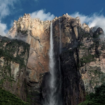


Which is the world’s tallest waterfall?


Spectacular Angel Falls is the world’s tallest waterfall. With a drop of 979 m (3,212 ft), it is more than twice the height of New York’s Empire State Building. American pilot Jimmy Angel first spotted the waterfall from the air in 1933.


Lying within the Canaima National Park, Angel Falls is part of the plateau that underlies the lands located in Venezuela to the south of the Orinoco River. The plateau's age is estimated at two billion years. Important geological transformations can be seen at the park, from its beginnings in the Precambrian period dating back to the time of the formation of the super continent Pangaea.


This continent began to separate due to the formation of a fracture in the planet's crust resulting in the formation of the Atlantic Ocean, and the creation of different portions of lands called shields. The geographic region in Venezuela, known as the Guyanese Shield, existed from the start as a great plain at an elevation roughly as high as today's visible tepuis, about 6500 to 9800 feet. After the formation of the great plain, during a long period of time—approximately 400 to 200 million years ago—a series of climate-related phenomena caused important changes in the geography of the Guyanese Shield.


The transformation of the landscape was due to drastic variations of arid climate to humid and vice versa; of strong, constant and lingering precipitations; droughts, freezing, discharges with high and low temperatures; storms, hurricanes, and the tectonic movements of the earth. The erosion was caused by atmospheric agents removing the material deposited in the great plain during millions of years. In places where the rock was less resistant, the erosion was greater resulting in this great transformation, the Tepuis, and the fantastic scenery at the Falls.


Picture Credit : Google


Which is the driest place on earth?


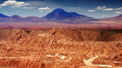
Covering 1,000 km (600 miles), Atacama Desert, Chile South American desert is one of the driest places on Earth. Some parts have not seen rainfall since records began at least 400 years ago! The northern part of the Atacama Desert contained valuable minerals. Bolivia and Chile attempted to claim the area in the 1800s, causing the War of the Pacific from 1879 to 1884. Chile claimed victory and won control of the region. The extreme ecosystem of the Atacama makes survival difficult for animals. However, red scorpions, grey foxes, desert wasps and butterflies are among the species able to cope with the dry environment. You can also find penguins, sea lions and pelicans nearer the Pacific side.


The Atacama Desert was at the centre of the world’s attention in 2010. Famous for the ‘Copiapo mining accident’, whereby 33 miners survived a record 69 days buried in a 120-year-old copper-gold mine. Thankfully, all 33 miners were safely rescued on 13th October 2010. Often compared to the planet Mars, the Atacama’s landscape and soils are unique. Its appearance is unlike other deserts and several movies and television programmes have been filmed in the area. One of the most famous of which is A Space Odyssey. The Atacama Desert is one of the top three destinations for visitors to Chile. The other top attractions include Easter Island and Chile’s Lake District.


Picture Credit : Google


Which is the world’s deepest cave?


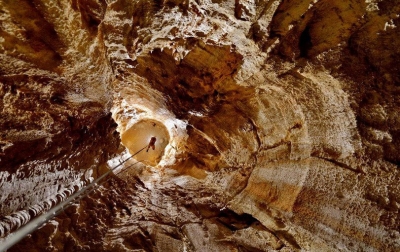
Krubera Cave, Georgia is the world’s deepest cave lies in Asia, Stretching down 2,197 m (7,208 ft), it is nearly as deep as seven of Paris’s Eiffel Towers. Russians call the cave Voronya, meaning “crow’s cave”, after the many crows nesting at the entrance.


Krubera Cave is a deep, mostly vertical cave system. Passages in the cave system can be narrow and difficult to pass or wide and very large. In order to explore the caves completely cave divers need to be prepared to put on scuba gear because tunnels in the caves can sometimes become flooded. Flooded tunnels are referred to as sumps. Some of the passageways in Krubera Cave had to be widened to make it possible for cave divers and explorers to venture further.


Picture Credit : Google


Which is the world’s longest river?


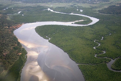
The world’s longest river is the Nile, at 6,825 km (4,238 miles) in length. It flows through 11 African countries, from Burundi to Egypt, where it meets the Mediterranean Sea. The Nile takes its name from the Greek for “river valley”.


The availability of water from the Nile throughout the year, combined with the area’s high temperatures, makes possible intensive cultivation along its banks. Even in some of the regions in which the average rainfall is sufficient for cultivation, marked annual variations in precipitation often make cultivation without irrigation risky.


The Nile River is also a vital waterway for transport, especially at times when motor transport is not feasible—e.g., during the flood season. Improvements in air, rail, and highway facilities beginning in the 20th century, however, greatly reduced dependency on the waterway.


Picture Credit : Google


Which is the world’s highest mountain?


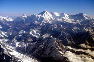
The peak of Mount Everest lies 8,848 m (29,029 ft) above sea level, making it the world’s highest mountain. It is ten times taller than the world’s tallest building- the Burj Khalifa skyscraper in Dubai.


Mount Everest attracts many climbers, some of them highly experienced mountaineers. There are two main climbing routes, one approaching the summit from the southeast in Nepal (known as the "standard route") and the other from the north in Tibet. While not posing substantial technical climbing challenges on the standard route, Everest presents dangers such as altitude sickness, weather, and wind, as well as significant hazards from avalanches and the Khumbu Icefall. As of 2017, nearly 300 people have died on Everest, many of whose bodies remain on the mountain.


Picture Credit : Google


What is Column?


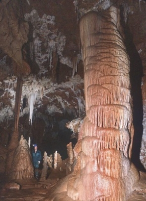
If a stalagmite and stalactite become long enough and meet, they will form a rocky column. Columns are also created when a stalactite grows down to touch the cave floor.


As compound cave formations, they include among their ranks the tallest free-standing speleothems in the world. (Certain flowstone falls--sheets of calcite lining vertical shafts--are undoubtedly taller, but rarely measured). The towering specimens of the upper left photo, from Ogle Cave in Carlsbad Cavern National Park, New Mexico, USA, are indeed impressive. These, however, are only about half as high as the 61-meter tall column in Tham Sao Hin, a cave in Thailand.


Picture Credit : Google


What are Soda straws?


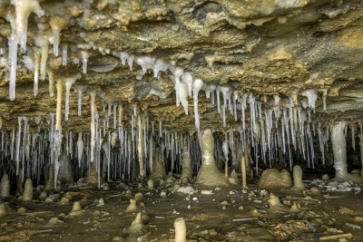
These thin, hollow tubes also form from dissolved particles in water, dripping slowly through the roof of a cave. They may grow into stalactites if the water keeps dripping for a very long time.


These tubes form when calcium carbonate or calcium sulfate dissolved in the water comes out of solution and is deposited. In soda straws, as each drop hovers at the tip, it deposits a ring of mineral at its edge. It then falls and a new drop takes its place. Each successive drop of water deposits a little more mineral before falling, and eventually a tube is built up. Stalagmites or flowstone may form where the water drops hit the cave floor.


Soda straws are some of the most fragile of speleothems. Like helictites, they can be easily crushed or broken by the slightest touch. Because of this, soda straws are rarely seen within arms' reach in show caves or others with unrestricted access. Kartchner Caverns in southern Arizona has well-preserved soda straws because of its recent discovery in 1974 and highly regulated traffic.


Picture Credit : Google


What is Stalactite?


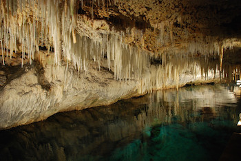
These hang down like icicles. They form in the same way as stalagmites, from rocky particles dissolved in water, this time dripping from the caves ceiling.


A drop on the tip of a growing stalactite leaves a deposit only around its rim. Downward growth of the rim makes the tube. The simplest stalactite form, therefore, is a thin-walled stone straw, and these fragile forms may reach lengths of 0.5 m (20 inches) or more where air currents have not seriously disturbed the growth. The more common form is a downward-tapering cone and is simply a thickening of the straw type by mineral deposition from a film of water descending the exterior of the pendant.


Picture Credit : Google


What is Stalagmite?


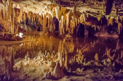
Water dripping onto the cave floor leaves behind tiny rocky particles that were dissolved in it. As the dripping continues, these particles can build up form a pillar of rock, or stalagmite.


Stalagmites have thicker proportions and grow up on the bottom of a cavern from the same drip-water source, the mineral from which is deposited after the water droplet falls across the open space in the rock. Not every stalactite has a complementary stalagmite, and many of the latter may have no stalactite above them. Where the paired relation exists, however, continual elongation of one or both may eventually result in a junction and the formation of a column.


Picture Credit : Google


What are Caves? What are the types of cave?


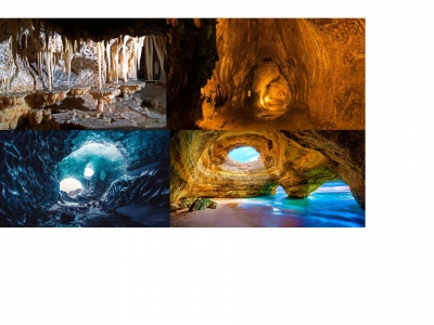
Caves are underground spaces or hole that are large enough for someone to enter. They form in many different ways, but mostly because of rock in the Earth’s surface being worn away or crumbling. Caves usually have lots of interesting and exciting features to explore.


There are many types of caves formed through different processes: some are small, and it is difficult for man to penetrate into; others, on the contrary, stretch underground for tens or hundreds of kilometres, reaching depths of over 2,000 m. Formation processes control length, development and shape of a cave, and also the difficulties that will arise when exploring them. Most of the longest and deepest caves do not consist in an isolated cavity, but they form a system, which at times may be very complex, made of rooms, sinkholes, shafts, meanders, canyons, interconnecting galleries, which are arranged to form a system or karst complex.

Large quantities of underground water move through karst systems, caves may therefore be classified in different sub-areas, i.e. occupied by air and completely dry or scoured by streams, they may be flooded at times, or permanently invaded by fresh and salt water.


Caves are found all over our planet. Some are small, single spaces, but others contain many chambers, linked by tunnels to form a huge maze of different areas. Although most caves are found in rock, some form in ice or lava.


Solutional caves


These are the most common type of cave. They are created when a build up acidic water dissolves the rock around it. Holes and tunnels start to appear, getting bigger and bigger as more rock dissolves and is washed away.


Solution caves are formed when groundwater seeps underground via cracks, faults, joints, bedding places, and other surface openings. Over geological epochs, small cracks in the rock become large cave systems. Limestone solution caves are very picturesque as they are often adorned with cave formations like stalactites and stalagmites formed by calcium carbonate precipitation. Such caves are formed by the dissolution of limestone by acidic water (water with dissolved carbonic acid).


Lava caves


When lava flows slowly over land around a volcano, it can harden on the surface, leaving liquid lava flowing underneath. This liquid drains away, leaving a hollow tube of rock that forms a cave.


When hot liquid lava flows down the slope of a volcano, the surface of the lava cools and solidifies. However, hot liquid lava continues to flow beneath the solidified surface and when the flow stops, a hollow tube remains. Such types of caves are called lava tubes. Lava mold caves, rift caves, inflationary caves, and volcanic conduits are other caves formed by volcanic activity. The Kazumura Cave in Hawaii is an example of a 65.8 km long lava tube.


Ice caves


Ice melting on top of a glacier can form a stream or waterfall that flows through the glacier. Eventually, this flowing water will hollow out part of the glacier, creating an ice cave.


The second type of ice cave occurs either when frigid winter air settles into downward-leading caverns where it cannot be forced out or when moisture freezes in currents of cold air. Frozen lakes, icicles, and ice draperies are common formations. Helictite-like icicles also form where air currents deflect the freezing water. The splendid ice deposits formed in the lava caves of the northwestern United States are dwarfed by the limestone ice-cave systems of the Alps.


Sea Caves


These are formed by waves constantly battering against cliffs along the seashore. This leads to cracks appearing in the cliffs that get larger as beating waves continue to wear away the rock.


Sea caves are often a major tourist attraction. Some sea caves can be accessed only by boats during low tide while others are more easily accessible and occur along beaches where it is possible to walk into the caves. Cathedral Cove Sea Cave, in Coromandel, New Zealand is an example of a sea cave.


Picture Credit : Google


What is the source of river?


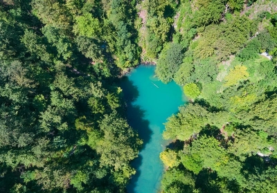
This is where a river starts, high up in the mountains. The source, or place where the river starts from, could be a springs or a lake, or even a melting glacier. A river can have more than one source.


The source is the farthest point of the river stream from its estuary or its confluence with another river or stream. Rivers are usually fed by many tributaries. The farthest stream is called the head-stream or head water. There is sometimes disagreement on which source is the head water, hence on which is the true source. Headwaters are usually in mountains. Glacial headwaters are made by melting glaciers.


The source is where a river begins, and the mouth is where it joins the sea. The source of a river generally discharges water with less force leading to the formation of Interlocking spurs.


The river mouth is the opposite of a river source. The mouth is where the river ends as it meets the ocean, and may have a river delta.


Picture Credit : Google


What are Rivers?


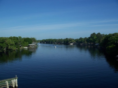
A river is a natural channel of fresh water that flows across the Earth’s surface. All rivers start in mountains or hills and flow down towards the sea or ocean, or into another large area of water. They may be short or flow for hundreds of kilometres.


Rivers are part of the hydrological cycle; water generally collects in a river from precipitation through a drainage basin from surface runoff and other sources such as groundwater recharge, springs, and the release of stored water in natural ice and snowpacks (e.g., from glaciers). Potamology is the scientific study of rivers, while limnology is the study of inland waters in general. Most of the major cities of the world are situated on the banks of rivers, as they are, or were, used as a source of water, for obtaining food, for transport, as borders, as a defensive measure, as a source of hydropower to drive machinery, for bathing, and as a means of disposing of waste.


Picture Credit : Google


What is weathering? What are the types of weathering?


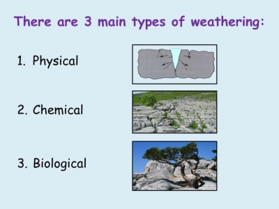
Weathering occurs when rocks are weakened, so that they crack and then break up into smaller pieces. This natural process can be caused by rainfall, changes in temperature or even by plants as they grow. Weathering and erosion constantly change the rocky landscape of Earth. Weathering wears away exposed surfaces over time. The length of exposure often contributes to how vulnerable a rock is to weathering. Rocks, such as lavas, that are quickly buried beneath other rocks are less vulnerable to weathering and erosion than rocks that are exposed to agents such as wind and water.


As it smoothes rough, sharp rock surfaces, weathering is often the first step in the production of soils. Tiny bits of weathered minerals mix with plants, animal remains, fungi, bacteria, and other organisms. A single type of weathered rock often produces infertile soil, while weathered materials from a collection of rocks is richer in mineral diversity and contributes to more fertile soil. Soils types associated with a mixture of weathered rock include glacial till, loess, and alluvial sediments.


Biological Weathering:


This is when plants or animals cause rocks to break up. Plant rocks to break up. Plant roots often grow into small cracks in rocks, splitting them apart. An animal digging can also turn rocks into rubble.


Microscopic organisms like algae, moss, lichens and bacteria can grow on the surface of the rocks and produce chemicals that have the potential of breaking down the outer layer of the rock. They eat away the surface of the rocks. These microscopic organisms also bring about moist chemical micro-environments which encourage the chemical and physical breakdown of the rock surfaces. The amount of biological activity depends upon how much life is in that area. Burrowing animals such as moles, squirrels and rabbits can speed up the development of fissures.


Chemical Weathering: 


Chemical reactions can break up rock. Acid rain, for example, destroys the stone in statues and buildings.


The natural chemical reactions within the rocks change the composition of the rocks over time. Because the chemical processes are gradual and ongoing, the mineralogy of rocks changes over time thus making them wear away, dissolve, and disintegrate.


The chemical transformations occur when water and oxygen interacts with minerals within the rocks to create different chemical reactions and compounds through processes such as hydrolysis and oxidation. As a result, in the process of new material formations, pores and fissures are created in the rocks thus enhancing the disintegration forces.


Physical or Mechanical Weathering: 


Wind water and temperature changes weaken rock. If water in a crack freezes, it expands and can tear a rock apart. One of the most common mechanical actions is frost shattering. It happens when water enters the pores and cracks of rocks, then freezes. Frost weathering, frost wedging, ice wedging or cryofracturing is the collective name for several processes where ice is present. These processes include frost shattering, frost-wedging and freeze-thaw weathering.


Another type of mechanical weathering is called salt wedging. Winds, water waves, and rain also have an effect on rocks as they are physical forces that wear away rock particles, particularly over long periods of time. These forces are equally categorized under mechanical or physical weathering because they release their pressures on the rocks directly and indirectly which causes the rocks to fracture and disintegrate.


Picture Credit : Google


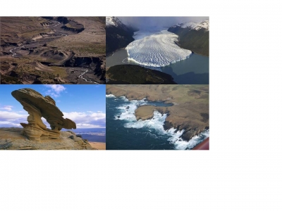
What is erosion? What are the agents of erosion?


Erosion is the wearing away of rocks and other matter on the Earth’s surface by a natural force, such as a sliding glaciers, a flowing river, or the wind. Material that is rubbed off is carried away and deposited somewhere else.


Most erosion is performed by liquid water, wind, or ice (usually in the form of a glacier). If the wind is dusty, or water or glacial ice is muddy, erosion is taking place. The brown color indicates that bits of rock and soil are suspended in the fluid (air or water) and being transported from one place to another. This transported material is called sediment.


Water erosion


This is caused by falling rain or flowing water. Rivers, for example, wear away the land that they flow over, changing the surrounding landscape. Raindrops hit bare soil with enough force to break the soil aggregates. These fragments wash into soil pores and prevent water from infiltrating the soil. Water then accumulates on the surface and increases runoff which takes soil with it.


Well-structured soils are less prone to break up, and the impact of raindrops is minimized if the soil surface is protected by plant or litter cover. 


Wind erosion


The force of the wind can remove pieces of rock and carry them off. Wind erosion is common in deserts. Wind erosion is a serious environmental problem attracting the attention of many across the globe. It is a common phenomenon occurring mostly in flat, bare areas; dry, sandy soils; or anywhere the soil is loose, dry, and finely granulated. Wind erosion damages land and natural vegetation by removing soil from one place and depositing it in another. It causes soil loss, dryness and deterioration of soil structure, nutrient and productivity losses and air pollution. Suspended dust and dirt is inevitably deposited over everything. It blows on and inside homes, covers roads and highways, and smothers crops. Sediment transport and deposition are significant factors in the geological changes which occur on the land around us and over long periods of time are important in the soil formation process.


Ice erosion


As glaciers move, they rub away the land under them, carrying the broken-down material with them. Ice erosion occurs in one of two forms, the movement of glaciers, or thawing processes. In the latter formation, water inside pores and rock fractures expand, which causes further cracking. Glaciers erode through one of three different processes, including abrasion, plucking, and thrusting. Debris caught in the basal brushes along the bed, which polishes and gouges the rocks underneath. Glaciers also cause bedrock to fall off during the plucking phase. In addition, glaciers freeze and then move forward, which dislodges the sediments at the glacier’s base. The latter method produces thousands of lake basins that lie across the edge of the Canadian Shield. All of these combined processes form moraines, drumlins, kames, moulins, and glacial erratics, especially at the glacier retreat.


Extreme cold weather temperatures cause trapped water particles to expand in its cracks, which breaks the rock into several pieces. This senior care leads to gravity erosion, particularly on steep slopes, and the formation of scree at the bottom of a mountainside. Morning thaws can present structural problems for roads alongside mountain cliffs. Additionally, trapped water in the wedge of a rock causes fissures, which eventually breaks down the rock.


Coastal erosion


Crashing waves gradually wear away the rock in cliffs, and sweep up material from the beach. Coastal erosion is typically driven by the action of waves and currents, but also by mass wasting processes on slopes, and subsidence (particularly on muddy coasts). Significant episodes of coastal erosion are often associated with extreme weather events (coastal storms, surge and flooding) but also from tsunami, both because the waves and currents tend to have greater intensity and because the associated storm surge or tsunami inundation can allow waves and currents to attack landforms which are normally out of their reach. On coastal headlands, such processes can lead to undercutting of cliffs and steep slopes and contribute to mass wasting. In addition, heavy rainfall can enhance the saturation of soils, with high saturation leading to a reduction in the soil's shear strength, and a corresponding increase in the chance of slope failure (landslides).


Coastal erosion is a natural process which occurs whenever the transport of material away from the shoreline is not balanced by new material being deposited onto the shoreline. Many coastal landforms naturally undergo quasi-periodic cycles of erosion and accretion on time-scales of days to years. This is especially evident on sandy landforms such as beaches, dunes, and intermittently closed and open lagoon entrances. However, human activities can also strongly influence the propensity of landforms to erode.


Picture Credit : Google