Which is the only country in the world where both the Prime Minister and the President are women?

The European nation of Estonia has become the only country currently in the world led by women. It means that both the president and the prime minister of the country are women. Estonia achieved this feat after Prime Minister Kaja Kallas took office on January 26.

It should be noted that Estonia is the only country where both women leaders are elected by the people. New Zealand, Barbados, and Denmark are three other countries with female prime ministers and heads of state, but the latter in these countries are monarchs and therefore not elected.

Estonia's President Kersti Kaljulaid appointed the 15-member Cabinet of Prime Minister Kaja Kallas and it was approved by the lawmakers in the country's parliament. Kallas, who is from the centre-right Reform Party, is also the first female prime minister of the country. In 2016, Kalijulaid became the first female president of Estonia since its independence.

Estonia with a population of 1.3 million is dealing with economic issues as a result of the coronavirus pandemic. That is going to be a big challenge for Kallas' new government.

Even though it is interesting that both Estonia's PM and the president are women, it may not last too long as the country will elect its new president in September. Kaljulaid has not specified yet if she would be in the fray for reelection.

Picture Credit : Google

Why is Arunachal Pradesh called the Land of the Rising Sun?

Known as "the Land of the Rising Sun", Arunachal Pradesh constitutes the mountainous area in the extreme northeastern part of the country and is bordered by Bhutan to the west, the Tibet Autonomous Region of China to the north, Myanmar and Nagaland to the south and southeast, and Assam to the south and southwest. The capital of the State is Itanagar.

It has long been recognized as part of the Indian subcontinent, receiving mention in such ancient Hindu literature as the Kalika-purana and the epic poems Mahabharata and Ramayana. Formerly known as the North East Frontier Agency (from the British colonial era), the area was part of Assam until it was made a Union Territory on 20 January, 1972. In 1987, it became an Indian State. Surprising as it may sound, Hindi is the lingua franca (common language) of Arunachal. The state bird of Arunachal is the Hornbill. Some of the major tribes like Nyishi wear hornbill hats at traditional rites and rituals and weddings.

Land

Most of Arunachal Pradesh's terrain consists of deep valleys flanked by highland plateaus and ridges that rise to the peaks of the Himalayas. The State encompasses three broad physiographic regions. Farthest south is a series of foothills, similar in type to the Siwalik Range (a narrow sub-Himalayan belt stretching across much of the northern part of India that ascends from the Assam plains to elevations of 1,000 to 3,300 feet). These hills rise rapidly northward to the Lesser Himalayas, where some ridges and spurs reach 10,000 feet. Farther north, along the Tibetan border, lie the main ranges of the Great Himalayas, where Kangto, the highest peak in the State, dominates the landscape, reaching about 23,260 feet.

People of Arunachal


Arunachal Pradesh is home to dozens of distinct ethnic groups, most of which are in some way related to the peoples of Tibet and the hill region of western Myanmar. More than two-thirds of the people are designated officially as Scheduled Tribes. In western Arunachal the Nissi (Nyishi or Dafla), Sherdukpen, Aka, Monpa, ApaTani, and Hill Miri are the main tribes.

The Adi, constituting the largest tribal group in the State, live in the centralregion. The Mishmi inhabit the northeastern hills, and the Wancho, Nocte, and Tangsa are concentrated in the southeastern district of Tirap. The Wanchos inhabit the Patkai hills of Longding District. They have a population of 35,000. Culturally Naga, they are ethnically related to the Nocte and Konyak Naga of the Mon and Tirap districts.

Most tribes generally share similar rural lifestyles and occupations; many are farmers who supplement their diet by hunting, fishing, and gathering forest products. Other than the Scheduled Tribes, much of the rest of the population consists of immigrants from Bangladesh, from Assam, Nagaland, and other States.

The art of weaving is especially important, and textile designs are unique to each group. The tribal groups speak about 50 languages and dialects, most belonging to the Tibeto-Burman branch of the Sino Tibetan language family. They are often mutually unintelligible; Hindi and English are highly used in the region. Each of the tribes follows its own social, cultural, and religious practices, and most are endogamous (marrying within the group).

Arunachal Pradesh has the lowest population density of any State in India. Most of the populace is concentrated in the low-lying valleys, with the hill peoples living in scattered upland communities. There are no cities and fewer than two dozen towns. Itanagar, in the southwest, is the state's largest town.

Plants and animal life

The State's diverse terrain, climate, and soils are reflected in its fauna and flora. About two thirds of the State is forested, with a wide belt of swampy rainforest lying along the foothills. Forests of tropical evergreens and subtropical pines (as well as subtropical mixed broad-leaved and pine forests) are found in lower elevations. As elevation increases, the woodlands give way to mixed and coniferous temperate forests.

Animal life includes tigers, snow leopards, elephants, wild buffalo, goral goats, species of deer, and primates such as gibbons, slow lorises, macaques, and capped langurs. Animals found at higher elevations include bharals (wild sheep), black bears, and red pandas. The rare musk deer and takin also are found. Arunachal has also plenty of fish, varieties of snakes, and many species of birds.

Agriculture and forestry

More than half of the population of the State is engaged in agriculture. Although settled agriculture, including wet-rice farming, has now expanded considerably, many still practise shifting agriculture (jhum), whereby the land is cleared by burning the vegetation, is cultivated for several years, and then abandoned in favour of another site. Rice, corn (maize), millet, and buckwheat are among the main crops grown by this method. Major commercial crops include oilseeds, potatoes, ginger, sugarcane, and vegetables.

Resources and power

Arunachal has significant, though largely unutilized, resource potential. Among its resources for generating energy are rivers, coal and petroleum; most of the State's power is provided by hydroelectric plants. In addition to hydrocarbons, other mineral resources of the State include dolomite, quartzite, limestone and marble. Efforts are now being made to expand hydroelectric and solar power generation.

The State's manufacturing sector consists primarily of medium-and small-scale industries. Basketry, weaving, and carpets are the main handicraft manufactures. Smaller-scale industries include rice and vegetable-oil milling, fruit processing, the manufacture of forest-based products, and steel fabrication. Sericulture (raw silk production) also is important, and the State produces many varieties of silk yarns.

Transportation and Telecommunications

The State's rugged terrain makes transport and communications extremely difficult. With few paved roads and with no railways, for long time, Arunachal's links with the rest of India are limited. Most of the major transportation centres serving Arunachal are in the neighbouring State of Assam: the nearest airport, near Lilabari, and the nearest railway station is in Harmoti. In 2014, a railway line was opened between Harmoti and Naharlagun. There are regular bus services from Itanagar to Guwahati, Tezpur, Dibrugarh, Tinsukia, Jorhat in Assam, and to Shillong in Meghalaya.

Telecommunications were largely undeveloped in the state, with landline telephone service limited mainly to the larger towns. Greater efforts have been made in expanding mobile service into the remote mountain areas. Internet access, although still fairly limited, has also increased now.

Constitutional framework

Arunachal Pradesh is a constituent unit of India, and, as such, the structure of its government, like that of most Indian states, is defined by the national constitution of 1950. The governor, appointed by the President of India, is the head of State and is assisted by an elected Chief Minister, Council of Ministers, and a unicameral Legislative Assembly.

Arunachal falls under the jurisdiction of the High Court of Guwahati, Assam. To handle cases from Arunachal Pradesh more effectively, a permanent Bench of the Guwahati High Court has been established in Itanagar, with a Chief Justice appointed by the Chief Justice of Assam.

Education

Despite the presence of numerous primary, middle, and secondary schools, the literacy rate in Arunachal Pradesh continues to rank among the lowest in India even in the early 21st century. There are a number of post secondary institutions, including Arunachal University at Itanagar, which was founded in 1984. Arunachal has specialized colleges focusing on such fields as education, engineering, industry, and forestry and agriculture.

The Catholic Education in Arunachal, for the past 25 years, records nearly 20,000 students studying in its 46 schools. Catholic education has reached Tirap, Changlang and Longding districts having 31 of the 46 schools. Changlang has maximum schools with 11 NES run schools and Tirap and Longding has 10 schools each. Lohit District has six schools, Namsai District has five and Lower Dibang Valley District has four. Lohit District has six schools, and Namsai District has five schools.

Institutions

Arunachal Pradesh has an array of notable cultural institutions, which together underscore the State's religious and cultural diversity. The state museum, which houses an ethnographic collection consisting of local archaeological finds, musical instruments, weavings, carvings, and other examples of material culture, is located in Itanagar. Situated there also are the Governor's Bungalow and a picturesque Buddhist temple. The northwestern extremity of Arunachal is famous for its 17th century Mahayana Buddhist Monastery with gold-lettered Buddhist scriptures. Parasuramkund, on the Lohit River in the State's eastern region, is a place of Hindu pilgrimage.

Festivals/Dances

The festival seasons are simply the best time to visit Arunachal as one has the opportunity to learn more about its cultural diversity. There are many agricultural, religious and socio-cultural festivals where people dance, sing, pray, express gratitude and make merry as a community. Some of its most popular festivals are Siang River Festival, Pangsau Pass Winter Festival, Ziro Festival of Music, Solung, Nyokum, Losar Festival, and Dree Festival.

Dances are an integral part of Arunachal's community life. Losar, Mopin, and Solung are major tribal festivals. Some of the important festivals of the State are: Mopin and Solung of the Adis, Lossar of the Monpas and Boori boot of the Hill Miris, Sherdukpens, Dree of the Apatanis, Si-Donyi of the Tagins, Reh of the ldu-Mishmis, Nyokum of the Nyishis, etc.

The biggest festival of the Nyishi tribe is Nyokum, celebrated on 26-28 February, every year. The word 'Nyokum' is a combination of the words Nyok which means 'land' and kum means 'togetherness', and during the festivals days all the gods and goddesses of the Universe are invited and invoked.

Places of tourist interest

Arunachal Pradesh offers numerous parks, gardens, wildlife sanctuaries, and other natural settings for outdoor recreation. Bhalukpong and Tippi, both in the southwest, and Bomdila all are noted for their abundant flora, especially orchids. Namdapha National Park, near Dibrugarh, has a wildlife sanctuary inhabited by tigers and leopards. In Naharlagun, the botanical garden at Polo Park sits atop a ridge overlooking the town.

Interesting facts about Arunachal Pradesh

1. Dong Valley, situated at an elevation of 1,240 metres, is the first to receive sunrise in the country.

2. In the Asian subcontinent, Arunachal is the only region inhabited by 26 major tribes and over 100 sub-tribes. It is the most linguistically-enriched region, with over 30 languages spoken.

3. Tawang Monastery in Tawang district is the largest monastery in India.

4. With a wide variety of mammals and nearly 200 species, Arunachal Pradesh is a Botanist Paradise.

5. Young innovator of the State, Anang Tadar, received the National Grassroots Innovator Award for his innovation 'Smart Goggle for the Blind'. The award was presented to him by President Ram Nath Kovind during the Festival of Innovation and Entrepreneurship 2019 at NIF Complex, Gandhi Nagar in Gujarat. Tadar invented a unique pair of goggles that uses ultrasound and infrared sensors to help the visually impaired detect obstacles in their path.

6. 26-year-old Taba Chake is quietly making his mark on the independent music scene from Mumbai. Taba sings in Hindi, English and Nyishi.

Picture Credit : Google

What flag is not a quadrilateral?

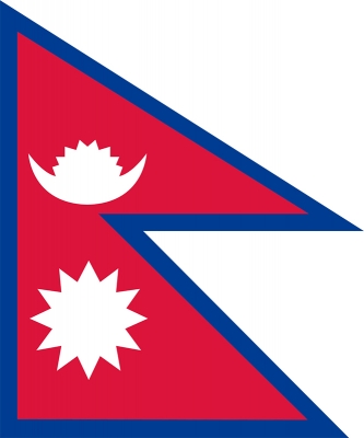
The national flag of Nepal is the world’s only national flag that is non-quadrilateral (non-rectangular) in shape. The flag is a combination of two single, triangular pennons or pennants, called a double-pennon. Nepal even has an article in its Constitution detailing the steps for making the flag.

The blue border symbolizes the peace and harmony that has been prevalent in the country since the age of Gautama Buddha, who was born in Nepal. The crimson red is Nepal's national color, and it indicates the brave spirits of the Nepalese people. The two triangles symbolize the Himalaya Mountains and represent the two major religions, Hinduism and Buddhism. The red triangular flag has been a Hindu symbol of victory since the time of Ramayana and Mahabharata. The depiction of celestial bodies represents permanence, the hope that Nepal will last as long as the sun and the moon. The moon symbolizes that the Nepalese are soothing and calm, while the sun symbolizes fierce resolve. The moon also symbolizes the shades and the cool weather of the Himalayas, whereas the sun symbolizes the heat and the high temperature at the lower part of Nepal. Another interpretation: The flag's shape symbolizes a Nepalese pagoda. Putting a mirror at the side of the flag closest to the flagpole will generate an image of a pagoda.

Picture Credit : Google
China is home to the first panda-shaped solar farm

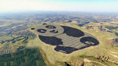
China is home to the first panda-shaped solar farm. Celebrating China’s iconic animal, the Panda Power Plant in Datong has an installed capacity of 50MW and will produce 3.2 billion KW of clean energy over the next 25 years. The panda is cherished by the Chinese people and the symbol of wildlife conservation. The plant was designed with a view to getting more young people interested in renewable energy. The solar farm is also home to an educational centre to teach students how a solar plant works and its advantages.

The project of the Panda Power Plant is ambitious. In fact, its installed capacity will reach 1MW in a 100-hectare area. According to the Panda Green Energy Group, once completed the Datong solar farm will produce 3.2 billion KW of clean energy over the next 25 years, saving 1,056 million tonnes of coal and reducing CO2 emissions by 2.74 million tonnes, equal to taking 73,000 cars off the road for 25 years.

Seen the success of the first solar farm, the Panda Green Energy Group aims to install more panda-shaped solar farms in China over the next five years. The projects will be included in the “Belt and Road” areas, i.e. those regions targeted by the economic development strategy of President Xi Jinping aimed at the cooperation between Eurasian countries. Also, the company doesn’t exclude that projects of this kind will be realised out of the country to celebrate local iconic animals like koalas, rhinos, and other animals that will bring clean energy to our future.

Picture Credit : Google

In which city is the highest cricket ground in the world?

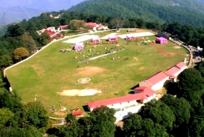
Standing at 2,444 metres above sea level, the Chail Cricket Ground located in Chail, Himachal Pradesh, is the highest cricket ground in the world. Built in the year 1893, it is being used as a playground by the Chail Miltary School.

This ground was made by the cricket loving Maharaja of Patiala- Bhupinder Singh. He decided to make his summer capital at this village but Lord Kitchener blocked his entry to Shimla in 1891. But, later he discovered a hilltop and built a cricket ground on it, which is covered by huge deodar and pine trees. During that period, the Maharaja used to play cricket with the British here but now it is under the control of Indian Army. On the other side of the ground, you'll find the colossal Himalayan ranges splendidly glittering in the sun and snow-clad everything thereunder.

Visitors can relish a splendid view of Sutlej Valley, Shimla and Kasauli at night from here. This ground is also used as the school playground by Chail Military School. There is a well maintained basket ball court and the same cricket ground also has goal posts that is used for playing football.


Picture Credit : Google

Who founded the modern Indian postal system and when?

India Post previously known as Department of Post, is a government-operated postal system in India, which is under the jurisdiction of Ministry of Communications. Generally called "the Post Office" in India, it is the most widely distributed postal system in the world. Warren Hastings had taken initiative under East India Company to start the Postal Service in the country in 1788. It was initially established under the name "Company Mail". It was later modified into a service under the "Crown" in 1854 by Lord Dalhousie. Dalhousie introduced uniform postage rates (universal service) and helped to pass the India Post Office Act 1854 which significantly improved upon 1837 Post Office act which had introduced regular post offices in India.[6] It created the position Director General of Post for the whole country.

The country has been divided into 23 postal circles, each circle headed by a Chief Postmaster General. Each circle is divided into regions, headed by a Postmaster General and comprising field units known as Divisions. These divisions are further divided into subdivisions. In addition to the 23 circles, there is a base circle to provide postal services to the Armed Forces of India headed by a Director General. One of the highest post offices in the world is in Hikkim, Himachal Pradesh operated by India Post at an altitude of 14,567 ft (4,440 m).


Picture Credit : Google

Which city of India has a floating post office?

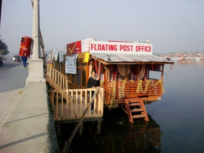
India is the only country in the world to have floating post office. This post office is located in Srinagar, Kashmir, on a houseboat in Dal Lake. It was inaugurated in August 2011. Did you know India has the largest postal network in the world? It has over 1,50,000 post offices across the country.

However, this post office marks its presence way before 2011. 

This floating post office is more than 200 years old established during the British Rule in India named as Nehru Post.

However, it was shut closed in 1990 due to the ongoing turmoil in the state. 

Later, it was started again in 2011 to provide a boost to the tourism sector in the state. 

It was then renamed as 'Floating post Office' by the Post Master, John Samuel.

During the devastating floods of 2014 in Kashmir, it was damaged badly but then restored to its previous glory.

It is the first floating post office in India provides services to more than 10 thousand residents of Srinagar.

However, it is not typically the only floating post office in the world.


Picture Credit : Google

Which senator sits at the candy desk?

In the last row of the Senate chamber, there is a desk that is always stocked with candy. It is on the Republican side, next to the chamber’s busy entrance. The tradition dates back to 1965 when California Senator George Murphy, who had a sweet tooth, kept candy on his desk for himself and other members. When Murphy’s term ended, other senators followed the custom.

When George Murphy departed the Senate in 1971, he left behind the tradition of the candy desk, but that’s just a small part of his legacy. Today, when senators reach into that well-stocked drawer, they might remember Senator Murphy—a one-time song-and-dance man whose political activism helped to promote a post-war resurgence of the Republican Party and set the stage for one of the party’s most influential leaders. There was a lot more to George Murphy than his sweet tooth.

The candy desk is not a specific desk in the Senate Chamber, but rather a specific seating within the chamber, and any desk that the senator seated in that position chooses to use becomes the candy desk. The desk's location has remained static since at least the 97th Congress (1981–1983). It is next to the eastern door to the senate chamber. Most senators enter the chamber through this door, which is adjacent to elevators leading to one of the stops on the United States Capitol subway system.

The desk is the first desk on the right, or Republican, side, and is in the last row of desks. Traditionally, the candy desk is always on the Republican side of the Senate Chamber and is used by a Republican senator. Since 2015, the desk has been occupied by Pennsylvania Senator Pat Toomey.


Picture Credit : Google

How did mariachi style music originate?

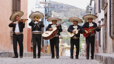
Walk into any Mexican restaurant and you will probably be greeted by musicians wearing wide-brimmed sombrero hats serenading you with their guitars. Do you know that these musicians, known as the mariachi, are part of an ancient musical tradition of Central America? Or that the mariachi was recognized by the UNESCO as an intangible cultural heritage in 2011?

Developed in the Mexican countryside, this form of music can be traced back to hundreds of years.

Whether it is a Quinceanera or a Cinco da Mayo celebration, the mariachi music is played on all special occasions. The music celebrates the joys, struggles, and the triumphs of the Mexican people.

How it evolved

The mariachi is not just a form of music, it encompasses an entire ensemble of music and dance. Varied versions of the mariachi exist in different regions of Central America. The musical form that is popular today took shape in the 19th Century in the state of Jalisco near Guadalajara. In 2011, the mariachi music made it to the UNESCO’s list of ‘intangible cultural heritage.’

Mariachi originated when Spanish conquistador Hernan Cortes invaded Mexico in the year 1519. Along with him came professional musicians carrying the harp and the vihuela (a smaller version of the guitar), commonly used in Spanish theatres. Their style of music was influenced by African sounds and was categorized under the mestizo folk music.

Etymology

No one knows how the term mariachi exactly originated. It is widely believed to have derived from the French word ‘mariage’. Mariachi bands would often play at weddings. However, over the years, it was discovered that the word had been in use in Mexico much before the French settled there. According to modern theories, mariachi has come from a native word for a tree whose wood is used to make the instruments and the platforms on which the musicians perform.

The modern mariachi

Mariachi bands today feature at least four musicians along with the violin, guitar, guitarron (a large bass guitar), and vihuela. Modern mariachi bands usually include trumpets and sometimes harps. Members of the band are attired in traditional charro suits with intricate embroidery and embellishments, waist-length jackets, bow ties, fitted pants, and sombreros.

Even today, the mariachi continues to be a huge part of the lives of the Mexican people. The serenata performed by the mariachi, for instance, is a form of communication between a young couple. It is a musical message of love delivered by the mariachi form is the “Las Mananitas”, which is performed during birthdays and days of religious significance. It is traditionally played early in the morning.

Picture Credit : Google

Which are the grand old trees of the world?

Old Tjikko

Old Tjikko is a 9,550-year-old Norway spruce, located in Sweden. The age of the tree was determined by carbon dating of its root system. It is 16 ft tall and is located on Fulufjallet Mountain of Dalarna province. Geologists Leif Kullman, who discovered the tree, named it after his dead dog.

Old Tjikko is, however, a clonal tree that has regenerated new trunks, branches and roots over millennia rather than an individual tree of great age. And it is believed to be the only living trunk of an ancient clonal colony. Clonal colonies are made up of genetically identical trees connected by a single root system. In general, spruce trees can multiply with the root penetrating branches to produce exact copies of themselves. So while the individual trunk is younger (only a few hundred years), Old Tjikko has been cloning itself for at least 9,550 years.

Scientists also reported that a cluster of around 20 spruces were found in the Swedish mountains that are estimated to be over 8,000 years old. The trees are able to survive very harsh weather conditions, and a warming climate has allowed them to thrive.

Methuselah

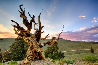
Methuselah, a bristlecone pine tree in California’s White Mountain range, is believed to be the oldest non-clonal tree in the world. It is over 4,800 years old. Methuselah is located between 9,500 and 9,800 ft above sea level in the “Methuselah Grove” in the Ancient Bristlecone Pine Forest within the Inyo National Forest in the United States. The exact location of Methuselah (and many other famous trees) is kept a secret due to fears of vandalism. All three species of bristlecone pine are long-lived and highly resilient to harsh weather and bad soil. The bristlecone pine is extremely drought-tolerant due to its branched shallow root system, its waxy needles, and thick needle cuticles that aid in water retention. The wood is also resistant to invasion by insects, fungi, and other potential pests.

Another bristlecone pine, nicknamed Prometheus, found in Nevada, was estimated to be 4,900 years old, when it was felled accidentally a scientist in 1964.

Llangernyw Yew

Llangernyw Yew, a lush tree in North Wales, is estimated to be 4,000 to 5,000 years old – must have germinated sometime in the prehistoric Bronze Age. Today it’s situated in the churchyard of St. Digain’s Church in Llangernyw village. Yew trees survive by regenerating. The centre of the Llangernyw yew is a void, where the original growth died back over the millennia. Younger wood grows around the void, drawing nutrients from the prehistoric roots. The girth of the tree at the ground level is 35.3 ft.

It is believed to be the oldest tree in Britain. In 2002, in celebration of the golden jubilee of Queen Elizabeth II’s accession to the throne, the tree was designated as one of 50 Great British trees by the Tree Council.


Picture Credit : Google

What is gold hallmarking?

The Government has called for mandatory hallmarking of gold jewellery in the market from June 1, 2021.

Certifying the purity of gold

The process of certifying the purity of gold is known as hallmarking. A hallmark is an official mark embossed on a piece of jewellery to guarantee the purity of the precious metal in it. Hallmarking gold jewellery instills confidence in the mind of the buyer. Let’s assume you are buying hallmark 22-karat gold jewellery. Do you know what it means? It means what you are purchasing has 22/24 parts gold, nothing more nothing less. This will ensure that you get the correct value of gold for the money you pay.

At present, gold hallmarking is voluntary. When hallmarking becomes mandatory, it would protect buyers against lower caratage and adulteration, and ensure that they got the purity as marked on the jewellery and are not cheated.

The Bureau of Indian Standards (BIS) is a government body that certifies the purity of the gold in the jewellery sold in the country. When a piece of jewellery conforms to a set of standards laid down by the BIS, it is awarded the BIS mark. The BIS logo on the jewellery indicates its purity has been verified. There are BIS-recognised Assaying & Hallmarking (A&H) Centres across the country to test jewellery and hallmarking it.

Gold of different karatage

24-karat gold is considered to be the purest form of gold. As it is soft, it does not lend itself to making ornaments. Other metals such as zinc, silver, and copper are added to strengthen gold to make jewellery. That’s the reason ornamental gold is categorized as 22-, 18- and 14-karat, which means 22-karat jewellery has 22/24 parts gold and 18-karat has 18/24 parts gold and the rest is a mixture of other metals.

What do the new rules say?

In 2019, the government had announced that mandatory hallmarking of gold jewellery would come into force on January 15, 2021, but was postponed to June due to the pandemic. According to the new rules, jewellers need to register themselves with the BIS. They can sell gold ornaments only in three variants – 22, 18 and 14 karat from June 1. They are prohibited from holding non-hallmarked jewellery. If jewellery or an artifact made of 22-18- and 14-karat gold is sold without the BIS hallmark, the jeweler could be penalized five times the cost of the object or imprisoned up to one year. It is said that the BIS has rolled out a host of reforms to make compliance easier. As an incentive to start-ups, the BIS has reduced the minimum marking fee by 50%. (According to the BIS site, it costs Rs. 35 plus taxes to hallmark a gold ornament.)

Meanwhile, jewellers citing their inability to get the old stock cleared or get all the jewellery pieces hallmarked on account of the pandemic, want the existing deadline to be extended to the start of 2022.

Picture Credit : Google

What are tropical cyclones? Why is their frequency increasing over the Arabian Sea in recent years?

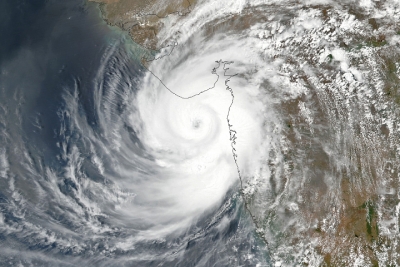
 As parts of India prepared to welcome the south-west monsoon, a powerful cyclonic system named Tauktae (pronounced ‘tau-tay’) wreaked havoc on the coastal areas of Gujarat, Maharashtra, Goa, Karnataka, and Kerala, mid-May.

Categorised as Extremely Severe Cyclone, Tauktae made landfall in Gujarat on May 17 and weakened into a ‘Very Severe’ category, with wind speeds of up to 160kmph. Unleashing a fury of rainfall and winds in the States along the west coast, the cyclone left a trail of destruction. Off the coast of Mumbai and Gujarat, two barges (freight-carrying boats) and an oil rig with hundreds of personnel on board were underway. Rains from the storm also killed many in Kerala, Karnataka, and Goa.

Cyclone Tauktae was the fifth-strongest cyclone ever in recorded history in the Arabian Sea. Scientists have been observing something unusual in the Arabian Sea in the recent years. There has been an increase in the frequency and strength of storms that originate in the sea.

What is cyclone?

The term cyclone refers to any spinning storm that rotates around a low-pressure centre. It is referred to by different names, depending on where it originates. If it forms over the South Pacific and the Indian Ocean, it is called a cyclone, if it originates in the Atlantic basin, it is a hurricane; and if it originates in the Northwestern Pacific Basin, it is called a typhoon.

In general such storms form over tropical or subtropical waters, and hence are called tropical cyclones.

How does a cyclone form?

Cyclones occur when warm, moist air over a warm ocean rises. As the air moves up, there is less air left on the surface, causing an area of low air pressure below. This area soon gets filled by air from the surrounding areas. Because of its proximity to the warm ocean water, this ‘new’ air gets warmer rapidly. It rises and condenses to form clouds and winds. This cycle continues. The whole system of clouds and winds gathers momentum and begins to swirl like a top, due to the rotation forms a relatively calm centre. This is called the eye of the storm.

High pressure air from above flows down into the eye, whipping up huge waves that are carried makes landfall at a coast, it not only brings very strong winds, but also heavy rains, causing a lot of damage. The cyclone gets stronger as it crosses the ocean, but loses strength once it hits the land.

Impact of cyclones

  • The cyclone comes with a wind speed ranging from 63 kmph to more than 200 kmph. At such speeds, the winds can be destructive, causing extensive damage to people and property.
  • The wind also brings heavy rains, sometimes leading to flooding.
  • Another deadliest outcome of a cyclone is a storm surge. A storm surge occurs when water level rises dramatically, with powerful winds pushing the ocean water towards the land. Storm surge is a threat to life and property. Surges can extend for dozens of miles inland, overwhelming buildings and cutting off roads quickly. The walls of water can begin even before a storm makes landfall, leaving little time to save lives. One of the best protections is evacuation of people to areas of higher elevation.

Different types

The wind speed of a cyclone determines its type. Based on the Tropical Cyclone Intensity Scale, which IMD uses, a cyclone is categorized in the following ways…

  • Super cyclonic storm (wind speed more than 221 kmph).
  • Extremely severe cyclonic storm (166-220 kmph).
  • Very severe cyclonic storm (118-165 kmph).
  • Cyclonic storm (63-88 kmph).

How cyclones get their names

  • Tropical storms and cyclones were earlier tracked by year and order of occurrence. Over time, they were given names for easy recognition. The World Meteorological Organisation, a UN body, maintains a list to name tropical cyclones around the world. Countries in the regions of hurricanes, typhoons and cyclones send suggestions for the list to the global met authority. Tauktae has been suggested by Myanmar, and in Burmese, it refers to a type of gecko.
  • The IMD is among six regional specialized meteorological centres in the world that have been mandated to name tropical cyclones in the north Indian Ocean region. Countries such as Bangladesh, the Maldives, Myanmar, Oman, Pakistan, Sri Lanka and Thailand suggest names for cyclones that form over the Bay of Bengal and the Arabian Sra, and they are used sequentially.

Spotlight on Arabian Sea

Historically, the Arabian Sea sees an average of two or three cyclones, that were typically weak, in a year. It is also a lot cooler than the Bay of Bengal, which is why it had fewer severe cyclones than the Bay of Bengal.

A study by the Indian Institute of Tropical Meteorology has shown that both the frequency and intensity of cyclones in the Arabian Sea are on the rise. Cyclone Tauktae is the first time since the start of satellite records in 1980 in India that there have been four consecutive years of pre-monsoon cyclones in the Arabian Sea. This is also the third consecutive year when a cyclone has come so very close to the west coast of India.

The experts believe the key reason is a rise in the ocean temperature as the Arabian Sea has become one of the fastest warming basins across the global oceans. Arabian Sea temperatures prior to cyclone formation are now 1.2-1.4  higher in the recent decades, compared to those four decades ago. This has led to an increase in the frequency and intensity of cyclones in the Arabian Sea, they say.

Role of global warming

Oceans soak up more than 90% of the heat generated by greenhouse gases, leading to rising water temperatures.

As cyclones draw their energy from warm waters, rising temperatures are causing intense storms to become more common.

The intensity of cyclones, hurricanes and typhoons might increase in the next century due to global warming, a joint British-American study published in April 2021, has said. Scientists, part of the study, analysed 90 peer-reviewed articles to understand the impact of a changing climate on tropical cyclones. They concluded that there could be a 5% increase in maximum cyclonic wind speeds if the world warmed by two degree Celsius by 2100.

Moreover, rising sea levels could also boost storm surges from cyclones, making them even more deadly and destructive.


Picture Credit : Google

Warming-Driven Glacier Melt Leads to ‘River Piracy’

As glaciers around the world are retreating rapidly, communities will be robbed of their rivers in the years to come, warn scientists.

They draw our attention to geomorphological phenomenon called ‘river piracy’, or ‘stream capture’, occurring when a stream or river drainage system is diverted from its own bed, and flows instead down the bed of a neighbouring stream. This can happen when there is a glacier melt, erosion, tectonic earth movement or landslide.

Alaskan river under threat

A new study has found that a major Alaskan river is under threat of being redirected in this way – stealing an essential source of water away from the ecosystem and people that rely on it. Scientists attribute this river piracy to glacier melt caused by global warming.

Scientists from the US National Park Service have predicted that a rapidly retreating glacier within Glacier Bay national park and reserve in Alaska is expected to change the course of the Alsek River it feels. The waterway originates in the St Elias mountain range in Canada and flows south into Alaska, entering the Pacific Ocean in a channel that flows through Dry Bay. Based on the researchers’ predictions, the mouth of the Alsek River could end up almost 30 km to the south east within the next 30 years. That has an impact on the surrounding wildlife, including the fish in the Alsek River and the community that has built up around the Dry Bay. The Dry Bay is a major point for fishery and rafting activities.

Impact on Slims River

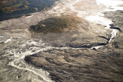
Scientist had earlier documented a river piracy event in 2016 in Canada’s Yukon Territory. A period of intense melting of the Kaskawulsh glacier permanently redirected the meltwater of the Slims River. The melting formed an ice-walled canyon, which redirected the Slims River flowing out to the Bering Sea, to flow into the Kaskawulsh River instead. River piracy which typically takes centuries happened over the course of one spring here.

It redrew the landscape of the area and affected the people, animals and birds are dependent on the river. Shifts in sediment transport, lack chemistry, fish populations, wildlife behaviour, and other factors continued to occur as the ecosystem adjusted to the new reality.

While river piracy, or a stream capture, is known to have happened in the past because of swings in Earth‘s climate, most of those examples were from thousands of years ago. These instances are the firsts attributed to human-caused climate change.


Picture Credit : Google

What is the Death Zone?

In mountaineering, it refers to altitudes beyond 26,000 ft above sea level, where oxygen levels are not sufficient to sustain human life.

The human body functions best at sea level where the atmospheric pressure is 101,325 Pa or 1013.25 millibars (or 1 atm, by definition). The concentration of oxygen (O2) in sea level air is 20.9% so the partial pressure of O2 (PO2) is about 21.2 kPa. In healthy individuals, this saturates hemoglobin, the oxygen-binding red pigment in red blood cells.

In the death zone and higher, no human body can acclimatize. The body uses up its store of oxygen faster than it can be replenished. An extended stay in the zone without supplementary oxygen will result in deterioration of body functions, loss of consciousness and, ultimately, death. Scientists at the High Altitude Pathology Institute in Bolivia dispute the existence of a death zone, based on observation of extreme tolerance to hypoxia in patients with chronic mountain sickness and normal fetuses in-utero, both of which present pO2 levels similar to those at the summit of Mount Everest.

Mountaineers use supplemental oxygen in the death zone to reduce deleterious effects. An open-circuit oxygen apparatus was first tested on the 1922 and 1924 British Mount Everest expeditions; the bottled oxygen taken in 1921 was not used (see George Finch and Noel Odell). In 1953 the first assault party of Tom Bourdillon and Charles Evans used closed-circuit oxygen apparatus. The second (successful) party of Ed Hillary and Tenzing Norgay used open-circuit oxygen apparatus; after ten minutes taking photographs on the summit without his oxygen set on, Hillary said he "was becoming rather clumsy-fingered and slow-moving".


Picture Credit : Google

Which is the deepest and highest point of the earth?

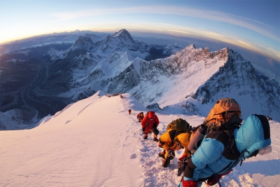
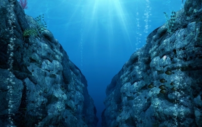
Located between Nepal and Tibet in the Himalayas range in Asia, Mt. Everest is the highest point on Earth. Its peak is 29.035 ft above sea level. The Mariana Trench in the western Pacific Ocean is the deepest natural point at 36, 201 ft below sea level.

Oxygen, needed to sustain animal life, comprises about 20.9 percent of the Earth’s atmosphere. Above 26,000 feet, the air contains insufficient oxygen to support human life. Climbers ascending the tallest mountains must bring breathing oxygen with them.

Below the surface of the sea, water pressure increases rapidly. At a depth of 33 feet (10 meters), the pressure increases to two atmospheres (that is, equal to twice the pressure of air at sea level. Every 33 feet, the pressure increases by one atmosphere.

Oceans cover about 71 percent of the Earth’s surface and support 50 percent of Earth’s species of life. The average depth of the ocean floor is 12,080.7 feet (3,682.2 m).


Picture Credit : Google