King George Island is located in which ocean?

King George Island (Argentina: Isla 25 de Mayo, Chile: Isla Rey Jorge, Russian: ????????? Vaterloo) is the largest of the South Shetland Islands, lying 120 km (75 miles) off the coast of Antarctica in the Southern Ocean.

The island was first claimed by the British in 1819 and named after King George III, however the following years were turbulent with many disputes about who owned the island.  In some form or another, Argentina, Brazil, Chile, China, South Korea, Poland, Russia, Uruguay, the Netherlands, Ecuador, Germany, Peru and the US all have a presence on the island. In so doing, these countries earn the status of a consultative party, or full member, of the Antarctic Treaty.

King George Island now serves as an aerodrome for flights to Antarctica, and is known as the unofficial capital of the continent because of the numerous research stations there. Aside from the scientific significance, the island is a haven for wildlife, and is home to many marine mammals such as Elephant, Weddell and Leopard seals, and colonies of Chinstrap and Gentoo penguins.

Picture Credit : Google

Greenland Island is located in which ocean?

Greenland is the world's largest island, located between the Arctic and Atlantic oceans, east of the Canadian Arctic Archipelago. Greenland is an autonomous territory within the Kingdom of Denmark. 

The coastline is rugged, mountainous and barren, with the land rising to a sloping ice cap that covers most of the island. Northeast Greenland National Park is the world’s largest national park. The Greenland ice sheet covers approximately 83% of the surface. The extreme north, Peary Land, is not covered by ice because the air is too dry to produce snow. If the Greenland ice sheet were to melt away completely, there would be a measurable rise in the world’s sea level.

Much of the economy is based on fishing, with shrimp fishing the largest income producer. Greenland appears to have large reserves of fossil fuels. The state oil company Nunaoil was created to help develop the future hydrocarbon industry. Mining of ruby deposits began in 2007.

Picture Credit : Google

The Bahamas Island is located in which ocean?

The Bahamas known officially as the Commonwealth of The Bahamas, is a country within the Lucayan Archipelago of the West Indies in the Atlantic. It takes up 97% of the Lucayan Archipelago's land area and is home to 88% of the archipelago's population. The archipelagic state consists of more than 700 islands, cays, and islets in the Atlantic Ocean, and is located north of Cuba and northwest of the island of Hispaniola (split between Haiti and the Dominican Republic) and the Turks and Caicos Islands, southeast of the US state of Florida, and east of the Florida Keys. The capital is Nassau on the island of New Providence. The Royal Bahamas Defence Force describes The Bahamas' territory as encompassing 470,000 km2 (180,000 sq mi) of ocean space.

Extensive and beautiful forests of Caribbean pine are found on Grand Bahama, Abaco, Andros, and New Providence islands. Hardwood forests also occur on some of the islands. Elsewhere the woody vegetation consists mostly of shrubs and low trees. Animal life is dominated by frogs, lizards, and snakes, all of them nonpoisonous, and several species of bats are found in caves along the more rocky coasts. Larger animals include the agouti, a rodent; the raccoon; the iguana; and the elegant flamingo, the national bird. All of these have been much reduced in numbers and in distribution. In addition, several animals—notably sheep, horses, and other livestock—have been introduced from Europe. The surrounding waters abound with fish and other edible marine animals, such as conch and spiny lobster (crayfish).

Picture Credit : Google

Fiji Island is located in which ocean?

Fiji is generally considered to be located in the South Pacific Ocean, the area between Viti Levu Island and the Lau Islands is actually called the Koro Sea.

Almost half of Fiji’s total area remains forested, while dry grasslands are found in western areas of the large islands. Coconut palms are common in coastal areas, and almost all tropical fruits and vegetables can be grown. Much of the shoreline is composed of reefs and rocks, while mangrove swamps are found on eastern coasts. There are few white-sand swimming beaches and, because of the encircling reef, little surf. Most animals, including pigs, dogs, cattle, and a few horses, are domesticated. Mongooses, introduced to prey on snakes and rats, are often seen.

The economy also has a strong service and light-industrial component serving small neighbouring countries as well as Fiji; activities range from boatbuilding (especially fishing boats and pleasure craft) to brewing and paint manufacture. The government offers incentives (including residence) for investors but insists on potential for job creation and training programs for local employees.

Picture Credit : Google

Madagascar Island is located in which ocean?

Madagascar is located in the southwestern Indian Ocean and is separated from the African coast by the 250-mile- (400-km-) wide Mozambique Channel.

Madagascar belongs to the group of least developed countries, according to the United Nations. Malagasy and French are both official languages of the state. The majority of the population adheres to Christianity, traditional beliefs, or an amalgamation of both. Ecotourism and agriculture, paired with greater investments in education, health, and private enterprise, are key elements of Madagascar's development strategy. Under Ravalomanana, these investments produced substantial economic growth, but the benefits were not evenly spread throughout the population, producing tensions over the increasing cost of living and declining living standards among the poor and some segments of the middle class. As of 2017, the economy has been weakened by the 2009–2013 political crisis, and quality of life remains low for the majority of the Malagasy population.

Along the length of the eastern coast runs a narrow and steep escarpment containing much of the island's remaining tropical lowland forest. To the west of this ridge lies a plateau in the center of the island ranging in altitude from 750 to 1,500 m (2,460 to 4,920 ft) above sea level. These central highlands, traditionally the homeland of the Merina people and the location of their historic capital at Antananarivo, are the most densely populated part of the island and are characterized by terraced, rice-growing valleys lying between grassy hills and patches of the subhumid forests that formerly covered the highland region. To the west of the highlands, the increasingly arid terrain gradually slopes down to the Mozambique Channel and mangrove swamps along the coast.

Picture Credit : Google

Why is the Sumatran rainforest in danger?

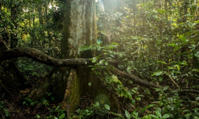
Declared a UNESCO World Heritage Site in 2004, the tropical rainforest regions in Indonesia's Sumatra Island comprise three national parks, namely Gunung Leuser National Park, Kerinci Seblat National Park, and Bukit Barisan Selatan National Park. Spread across more than 25,000 sq.km. a portion of the area falls within Sumatra's Leuser ecosystem that's often described as "the last place on Earth where tigers, rhinos, orangutans and elephants still live together".

The Parks, which are located on the spine of Bukit Barisan Mountains of Sumatra, show amazing uniqueness in biodiveristy, and are home to 10,000 species of plants. The regions also show a stunning variety in ecosystem from lowland rainforest to montane forest and subalpine low forest to scrub and shrub vegetation. The Gunung Leuser National Park is the place to see both the world's largest flower (Rafflesia arnoldi) and the tallest flower (Amorphophallus titanum).

Wildlife

The area is said to nurture more than 500 species of birds. Ducks, geese, partridges, scrubfowls, pheasants, grebes, pigeons, doves, quails, cuckoos, coucals, malkohas, koels, frogmouths, nightjars, swifts, swiftlets, needletails, rails, waterhens, crakes, thickknees, stilts, plovers, lapwings, snipes, jacanas, sandpipers, pratincoles, gulls, terns, petrels, shearwaters, storks, frigatebirds, tropicbirds, boobies, darters, cormorants, pelicans, herons, bitterns, egrets, ibises, kites, buzzards, eagles, owls, harriers, trogons, hornbills, kingfishers, bee-eaters, rollers, woodpeckers, barbets, kestrels, falcons, parakeets, broadbills, pittas, ioras, minivets, shrikes, orioles, drongos, fantails, flycatchers, magpies, swallows, bulbuls, warblers, tailorbirds, white eyes, babblers, thrushes, mynas, starlings, leafbirds, flowerpeckers, sunbirds, spiderhunters, wagtails, weavers, munias, and finches are among the birds that can be spotted in the region. The place also supports more than 200 mammal species, including several that are endemic and endangered. The mammals include the endemic Sumatran orangutan, the Sumatran tiger, dlouded leopard, rhinoceros, elephant, and the Malayan sun bear.

Threats

  • Given the expansive wealth of natural resources in the region, Sumatra has attracted heavy international financing zeroing in on extractive industries, "from precious hardwoods and minerals to palm oil, rubber, and coal". As a result, the precious wildlife in the area is losing their habitats and faces a very bleak future.
  • Road development in the rainforests is of great concern because they not just destroy the natural landscape and displace wildlife, but also provide access to people for illegal logging, encroachment, and poaching.
  • Agriculture is another cause of worry. As rainforests are wiped off to give way for agriculture, it becomes difficult to reclaim the lost forest area. In fact, a study less than a decade ago had said that the rainforests of Sumatra are likely to disappear in 20 years. So, right now, we have perhaps about 10 years to save the rainforests. This would also mean the eventual, permanent disappearance of some of the rarest wildlife species on the planet.
  • In 2011, the UNSECO placed the region under its List of World Heritage in Danger. Mining, encroachment, development activities, and, to a certain extent, invasive species are among the several threats to the rainforests in Sumatra listed by it.

Picture Credit : Google