What is the Four Corners area of the US?

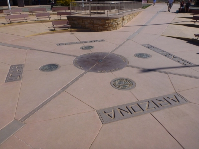
The Four Corners is a region of the United States where the boundaries of the four states of Utah, Arizona, New Mexico, and Colorado meet. The quadripoint is marked by a monument in granite and bronze. It is the only place where you can be in all four states at the same time. A popular tourist attraction, the site is maintained by the Navajo Nation which is the largest Native American territory in the U.S.

The Four Corners are marked by the Four Corners Monument, which is a popular tourist attraction. However, that isn’t all that the region has to offer. Many other areas in the region are visited by tourists, including Mesa Verde National Park and the Canyon de Chelly National Monument.

Most of the land that makes up the Four Corners area is owned by semi-autonomous Native Americans, including the Navajo Nation, the Ute, Zuni, and Hopi tribes.

Most of the region is rural. The only metropolitan area, which is also the economic hub of the region, is Farmington, a city in New Mexico. This is the most populous city with a population of just over 45,000 people.

The United States has many interesting landmarks. From the Grand Canyon to Mount Rushmore to Niagara Falls, you can see it all in the United States. One of the unique landmarks in the United States is the Four Corners Monument, which marks an area of the nation where four states meet.

What makes the Four Corners region so unique is that it is the only point in the U.S. where four states meet. This region in the Southwestern United States was originally Indian land before being claimed by Spain. After Mexico became independent from Spain, it became the owner of this land. However, Mexico ceded the property over to the United States in the mid-1800s during the Mexican-American War. In the years that followed, territories were broken up into states, and the 4 Corners region became the first of its kind in the nation.

Credit : World Population Review

Picture Credit : Google

What causes desertification in the Gobi Desert?

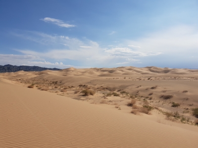
Spanning large parts of southern Mongolia and northern China the Gobi Desert is the largest desert in Asia and the fifth largest in the world. This cold desert is in the rain shadow of the Himalayas. It covers an area of about 13.00,000 sq.km, and despite its popularity as a desert, a large expanse of the region is bare rock. The Desert is almost entirely waterless, but there are salt marshes within its confines. Since it is spread across a vast area, the place has been divided into five distinct ecoregions, including those exhibiting characteristics of semi-desert and desert steppes. The conditions are harsh, and the climate, remarkably extreme in several areas with very cold winters and very humid summers. The vegetation is sparse in the region, and is dominated by succulents, desert grass, and bushes. Despite this, the region exhibits variety in terms of birds, animals, insects and the like.

This cold desert is also of great importance to study the evolution of life on our planet, since fossils of dinosaurs and mammals dating back to millions of years have been excavated from here. As with most places across the world, the Gobi Desert has its share of concerns too, chief among them being desertification.

Wildlife

Despite the sparse vegetation, several species of birds can be spotted in the region. Among them are falcons, sandgrouses, Mongolian groundjays, wheatears, sparrows, plovers, warblers, cuckoos, owls, doves, pigeons, cranes. hoopoes, partridges, stints gulls, terns, lapwings, stilts, grebes, spoonbills, egrets ,herons, kestrels, pintails, geese, ducks, pochards, eagles, goshawks, buzzards, vultures, bustards, cormorants, stonechats, redstarts, flycatchers, tits, starlings, thrushes, buntings, wagtails, pipits, and larks. Among the animals found here are Bactrian camels, foxes, wolves, gazelles, antelopes, Mongolian wild ass, Gobi ibex bears, and rodents such as marmots and jerboas. The snow leopard is said to inhabit the Desert too and is among the chief predators. In addition to snake species such as pit vipers and many varieties of frogs, the region hosts about 30 species of lizards that thrive well in and around the desert sands.

Threats

  • Desertification refers to the degradation of fertile land to dry land. Among reasons that cause this are climate change and human activity Desertification has severe ecological and environmental impact. The Gobi Desert is the fastest growing desert today. Due to this, several km of grassland has been gradually turning into wasteland with each passing day
  • Overgrazing of livestock too is considered one of the reasons for the desertification of lands. Not just that it also has led to the reduction in the quality of existing desert soil, thereby depriving the soil of sources of nutrients that support life.
  • In addition to these, over-cultivation badly drained irrigation systems and the mismanagement of water in the region risk to this ecosystem. When the environment is thus affected, it invariably affects the wildlife in the region too. Since the area pose a supports millions of people, long-term degeneration will have a negative impact on humans also. There have been reports of mining in the area, and it has been of grave concern.

Picture Credit : Google

What is Dholavira famous for?

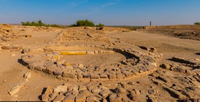
Dholavira is a well-preserved Harappan-era city situated in the Rann of Kutch, Gujarat. It is the fifth largest metropolis of Indus Valley Civilisation excavated so far, after Mohenjo Daro, Harappa, and Ganeriwala in Pakistan, and Rakhigarhi in Hanjana, India. Dholavira is also the most dominant archaeological site of the Indus Civilisation in India.

The ancient city, dating from the 3rd to mid-2nd millennium BCE (3000-2500 BCE), was excavated by the Archaeological Survey of India in 1967. The site, which served as a commercial hub for over 1,500 years before its decline in 1500 BC has a citadel, a middle town, and a lower town with walls made of stone. According to UNESCO, the ancient urban settlement stands out for its water management system, multi-layered defensive mechanisms, extensive use of stone in construction, and special burial structures. A range of artefacts of copper, shell, stone, jewellery, and terracotta had been found at the site. Sites such as these provide valuable insights into the ways of life of earlier societies, their knowledge, and customs.

With Dholavira joining the coveted list,Gujarat now has four world heritage sites - the others being Rani Ki Vav of Patan, Champaner fort, and Ahmedabad City.

The Indus Civilisation

The Indus Valley Civilisation or Harappan Civilisation was one of the earliest human civilisations which flourished around 2.500 BC in the western part of South Asia (present day Pakistan and western  India) Basically an urban civilisation, it was characterised by neatly planned, well-built cities which served as centres of trade. So far over 1.400 sites of the indus Civilisation have been discovered, of which over 900 are in India and over 400 in Pakistan.

What is a World Heritage Site?

 A World Heritage Site is a place designated by UNESCO (the United Nations Educational, Scientific and Cultural Organization) for its special cultural, historic or physical significance. The list of World Heritage Sites is maintained by the World Heritage Programme administered by the UNESCO World Heritage Committee. UNESCO, headquartered in Paris, France, seeks to encourage the identification, protection and preservation of heritage around the world.

What does the status mean?

UNESCO awards world heritage status to sites considered to be of special value to humanity. The sought-after distinction brings intangible benefits boosts tourism, and can help secure funding for the preservation of sites.

Picture Credit : Google

Where is Giant’s Causeway located?

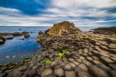
Giant’s Causeway, Irish Clochán an Aifir, promontory of basalt columns along 4 miles (6 km) of the northern coast of Northern Ireland. It lies on the edge of the Antrim plateau between Causeway Head and Benbane Head, some 25 miles (40 km) northeast of Londonderry. 

Formed 50 to 60 million years ago, during the Paleogene Period, the Giant’s Causeway resulted from successive flows of lava inching toward the coast and cooling when they contacted the sea. Layers of basalt formed columns, and the pressure between these columns sculpted them into polygonal shapes that vary from 15 to 20 inches (38 to 51 cm) in diameter and measure up to 82 feet (25 metres) in height. They are arrayed along cliffs averaging some 330 feet (100 metres) in elevation.

First documented in 1693, the formation has been intensively studied by geologists. The Giant’s Causeway and its coastal environs were bequeathed to the National Trust (a British organization that promotes the preservation of natural and architectural wonders) in 1961. Subsequently, the site was extended to some 200 acres (80 hectares); it was designated a UNESCO World Heritage site in 1986. It is protected not only for its beauty but also because its cliffs, seashores, marshes, and grasslands are home to some 50 species of birds, as well as to more than 200 species of plants. Humans settled around the Giant’s Causeway in the 19th century, but the site is now uninhabited. It does, however, attract some 300,000 tourists annually. Deriving its name from local folklore, it is fabled to be the work of giants, particularly of Finn MacCumhaill (MacCool), who built it as part of a causeway to the Scottish island of Staffa (which has similar rock formations) for motives of either love or war.

Credit : Britannica

Picture Credit : Google

Where is Salar de Uyuni located?

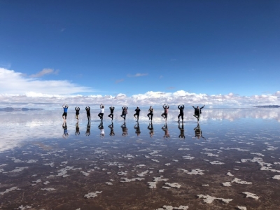
The largest salar (salt flat) in the world, Salar de Uyuni, is located within the Altiplano of Bolivia in South America. The Altiplano is a high plateau formed during uplift of the Andes Mountains. The plateau harbors fresh and saltwater lakes, together with salars, that are surrounded by mountains with no drainage outlets—all at elevations greater than 3,659 meters (12,000 feet) above mean sea level. The Salar de Uyuni covers approximately 8,000 square kilometers (3,100 square miles), and it is a major transport route across the Bolivian Altiplano due to its flatness.

The Salar was formed as a result of transformations between several prehistoric lakes. It is covered by a few meters of salt crust, which has an extraordinary flatness with the average elevation variations within one meter over the entire area of the Salar. The crust serves as a source of salt and covers a pool of brine, which is exceptionally rich in lithium. The large area, clear skies, and exceptional flatness of the surface make the Salar ideal for calibrating the altimeters of Earth observation satellites. Following rain, a thin layer of dead calm water transforms the flat into the world's largest mirror, 129 km (80 mi) across.

The Salar serves as the major transport route across the Bolivian Altiplano and is a prime breeding ground for several species of flamingos. Salar de Uyuni is also a climatological transitional zone since the towering tropical cumulus congestus and cumulonimbus incus clouds that form in the eastern part of the salt flat during the summer cannot permeate beyond its drier western edges, near the Chilean border and the Atacama Desert.

Picture Credit : Google

Where is Crystal Cave located?

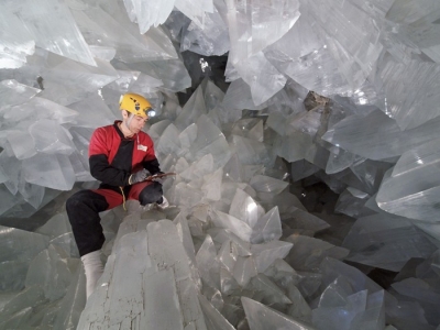
Cave of the Crystals or Giant Crystal Cave (Spanish: Cueva de los cristales) is a cave connected to the Naica Mine at a depth of 300 metres (980 ft), in Naica, Chihuahua, Mexico. 

The cave was discovered in April 2000 by brothers Juan and Pedro Sanchez while drilling in the mine. As of October 2015, the mine had reflooded and the cavern filled once more with the water rich in minerals required for the crystals to grow.

A group of scientists in the Naica Project have been studying these caverns.

In 1910, miners discovered a cavern beneath the Naica Mine workings, the Cave of Swords (Spanish: Cueva de las espadas). It is located at a depth of 120 metres (390 ft), above the Cave of the Crystals, and contains spectacular, smaller (1-metre (3 ft 3 in) long) crystals. It is speculated that at this level, transition temperatures may have fallen much more rapidly, leading to an end in the growth of the crystals.

Giant Crystal Cave was discovered in April 2000 by miners excavating a new tunnel for the Industrias Peñoles mining company located in Naica, Mexico, while drilling through the Naica fault, which they were concerned would flood the mine. The mining complex in Naica contains substantial deposits of silver, zinc and lead.

The Cave of Crystals is a horseshoe-shaped cavity in limestone. Its floor is covered with perfectly faceted crystalline blocks. Huge crystal beams jut out from both the blocks and the floor. The crystals deteriorate in air, so the Naica Project attempted to visually document the crystals before they deteriorated further.

Two other smaller caverns were also discovered in 2000, Queen’s Eye Cave and Candles Cave, and another chamber was found in a drilling project in 2009. The new cave, named Ice Palace, is 150 metres (490 ft) deep and is not flooded, but its crystal formations are much smaller, with small "cauliflower" formations and fine, threadlike crystals.

Picture Credit : Google

Where is Mount Roraima located?

Mount Roraima, Spanish Cerro Roraima or Monte Roraima, Portuguese Monte Roraímã, giant flat-topped mountain, or mesa, in the Pakaraima Mountains of the Guiana Highlands, at the point where the boundaries of Brazil, Venezuela, and Guyana meet. 

Mount Roraima is situated on the border of Venezuela, Guyana and Brazil, with almost 75% of the mountain falling into Venezuelan territory.
Whilst the tepui (table-top mountain) is the highest landform in Guyana, both Brazil and Venezuela have higher landmarks.
The summit experiences heavy rainfall all year round, which as a result of its flat surface, leads to random waterfalls popping up at various locations across the plateau.
Angel Falls, the tallest waterfall in the world, is located on a similar table-top mountain approximately 130 miles away, and falls within the same national park.
The formation was first described by the English explorer Sir Walter Raleigh in 1596 after his visit to Guyana in search of the legendary golden city of El Dorado, but frustratingly he was unable to climb it as no viable route to the summit was known at the time.
Mt. Roraima was the first major tepui in the world to be climbed in 1884, when Everard Thurn trekked up a forested trail. This trail is the only ‘easy’ way up, following a natural staircase like route on the Venezuelan side. Other routes do exist, though are extremely difficult and require technical rock climbing experience. Everard Thurn later went on to become the Governor of Fiji.

The summit measures 31 sq. km (12 sq. mi), and is usually covered in fog. It features black rocks, gorges, wildflower gardens and a number of pools.
The mountain has always had special significance to the indigenous Pemon Indians, and is central to many legends and myths passed down through generations. They view Roraima as the stump of a ginormous tree that once held all the fruits and vegetables in the world.
Translated, roroi means “blue green” and ma means “great” in the native language of the Pemon.
Mount Roraima and the other tabletop mountains in Canaima National Park are considered to be the oldest geological formations on Earth, dating back around 2 billion years to the Precambrian Era.

Credit : Britannica

Picture Credit : Google

Where is Darvaza gas crater?

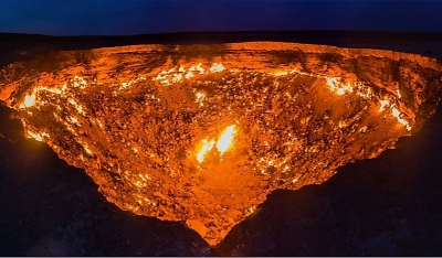
The Darvaza gas crater also known as the Door to Hell or Gates of Hell, is a natural gas field collapsed into a cavern near Darvaza, Turkmenistan.

The gas crater is near the village of Darvaza, also known as Derweze. It is in the middle of the Karakum Desert, about 260 kilometres (160 mi) north of Ashgabat, the capital of Turkmenistan. The gas reserve found here is one of the largest in the world. The name "Door to Hell" was given to the field by the locals, referring to the fire, boiling mud, and orange flames in the large crater, which has a diameter of 70 metres (230 ft). The hot spots range over an area with a width of 60 metres (200 ft) and to a depth of about 20 metres (66 ft).

The crater was featured in an episode of the National Geographic Channel series Die Trying. In the July 16, 2014, episode "Crater of Fire", explorer George Kourounis became the first person to set foot at the bottom, gathering samples of extremophile microorganisms. An edited photograph of the crater was also released as publicity for the then-upcoming 2014 Godzilla film, with the image depicting MONARCH agents and vehicles investigating the site.

Although the crater has captured public imagination as a mystery and has been named the "Gates of Hell", the crater is a simple geological anomaly; a superficial gas pocket which allowed the ground to sink into a natural depression, allowing the slowly escaping natural gas from a large deeper natural gas field to both accumulate and burn without being extinguished by the wind, or rapidly diluted. The gas from similar, smaller gas leaks in the area is rapidly dispersed by the desert wind. "Burning ground" sites where natural gas escaping from the ground has been ignited are found in other parts of the world.

Picture Credit : Google

Which is world's largest third-order island?

Victoria Island in Canada's Nunavut territory is the eighth largest island in the world and the second largest island in Canada. As of now, it houses the world's largest third-order island (an island in a lake on an island in a lake on an island), which measures about four acres. The third-order islet remains unnamed.

Amazingly, a third order inception is not in itself unique; a third order island is also found inside the crater lake of Taal Volcano Island in the Philippines, for example. But at four acres, the third order island in Canada is much larger than that of the Philippines, and possibly the largest in the world. 

It is quite possible that this small island has never been visited before. The nearest civilians live in Cambridge Bay, 90 miles away from this isolated island, and no roads come anywhere near. Hire a helicopter and you could be the first person to set foot on this sub-sub-sub island.

It is also quite possible, though, that this island is not the largest third order island in the world after all. The terrain of Victoria Island and nearly half of Canada is freckled with tiny, splotched lakes. This means that there is likely another—perhaps larger—third order island in another part of Canada. 

Credit : Atlas Obscura

Picture Credit : Google

Where are gharials found in Odisha?

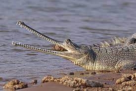
This May, a forest protection team spotted a gharial female with as many as 28 of its hatchlings at a nest on the banks of the Mahanadi in Odisha. Why is this news of significance?

Around the early 1970s, the gharial population in Satkosia gorge (part of the Satkosia Tiger Reserve's core area) had come down drastically. This is said to have largely been due to fishing and poaching in the area. Shortly, in a move to conserve gharials, the government, in collaboration with various stakeholders, started the captive breeding programme for the reptile. It is said that in the four decades since 1977, more than 850 gharials were released into the Mahanadi. And shockingly, a census in 2018 revealed that only a dozen of those had survived!

Research was taken up immediately to find out what had gone wrong so a solution could be found. The team found that illegal fishing and mining practices were affecting the creatures as was their conflict with mugger crocodiles. Just as importantly, these reptiles were also getting caught in fishing nets and meeting unfortunate ends. And so, the team came up with a brilliant solution-waiting longer before releasing captive-bred gharials.

Earlier, the gharials were released when they were about one metre long. These young ones wandered off far and quickly, invariably to untimely deaths. So, gharials only at least two metre long were released. Since they were now fitted with radio transmitters, they could be tracked too. Thus fisherfolk were alerted about the reptile movement, helping these creatures dodge death. Also, fisherfolk and villagers in the surrounding areas were educated about the need for reptile conservation, and fisherfolk were compensated if their nets were damaged due to gharial entanglement. Meanwhile, personnel also stepped up vigil along the banks of the Mahanadi.

And it was after all these efforts that the gharial breeding in the wild seems to have happened. Though the hatchlings appeared to have done fine, their survival rate is low. But the fact that the initiative has paid off has given officials hope and renewed vigour to step up conservation efforts. Perhaps this heartening story of success could be emulated elsewhere and for other species too.

Picture Credit : Google

What is hydrography?

Our Earth is a water world. It is the availability of water that makes our planet unique in the solar system. Approximately 71% of the earth's surface is covered by water. The oceans and the seas account for 97%. The rest exists as lakes and rivers, as glaciers and ice caps, and as aquifers. This is so enormous an area that any amount of knowledge of the science and geography of water sources wouldn't be enough. There are different forms of studies such as hydrology, oceanography and limnology that try to understand water and water bodies. And today, we are going to focus on hydrography.

What is hydropgraphy? In the past, ships were one of the major transport systems - they ferried people and goods across the world. But they often ran aground or overturned after striking an underwater rock or mudbank. The need to know the geography of the ocean floors, thus, was strongly felt. Individual mariners began to make charts and describe the bodies of the water to aid navigation. Today, surveyors use technology to map the sea floor. and scientifically and systematically measure and describe the physical features of bodies of water, including the ocean, coastal zones, rivers, and lakes. This is called hydrography.

Hydrography involves measuring the depth of the water and fixing the position of all the navigational hazards that lie on the senfloor, such as: wrecks and rocks. That data is used to update nautical charts and develop hydrographic models Hydrography also involves measuring the tide and the currents

Hydrography comprises two distinct branches. While marine hydrography is the study of the ocean floor, the coasts, tides and currents, hydromorphometric is dedicated to the study of river basins their shapes, dimensions and composition. The second branch helps us apply the knowledge for irrigation, river navigation and power generation.

Today, hydrographic maps are important in informing ocean resource management policies, predicting geohazards, and characterising habitats. Some hydrographers also study the physical and chemical properties of the sea and other water bodies, such as temperature, dissolved oxygen, and salinity.

How is hydrography done?

Surveying with multibeam echo sounders is the primary method of obtaining hydrographic data. The beams sweep the seafloor and bounce off details of the depth of the surveyed area. Sonan, aircraft fitted with lasers and satellite observations are also used in hydrography.

Picture Credit : Google

What causes sea-level rise?

The Intergovernmental Panel on Climate Change's (IPCC) Sixth Assessment Report (AR6) 'Climate Change 2021: The Physical Science Basis' was released recently. The report was approved by 195 member governments of the IPCC through virtual sessions held over two weeks in July and August. The report pointed out that every region in the world is witnessing irreversible changes in climate due to human influence. Sea level rise, floods, heavy rainfall and glacier melting are some of these irreversible effects. The report warned that extreme sea level events that previously occurred once in 100 years could happen every year by the end of this century.

Using the extensive data on future sea level rise from the IPCC, the National Aeronautics and Space Administration (NASA) of the United States has created a visualisation tool accessible to the public. The tool allows users to view both global and regional sea level projections from 2020 to 2150, along with how these projections differ depending on future scenario. Users can click on a point anywhere in the ocean to obtain the IPCC projection of sea level for that individual location.

As for India, the NASA tool predicts some grim future. The rising sea level threatens to submerge at least 12 coastal cities in the country. What are these cities and how grave is the threat? What causes sea level rise?

What does the tool predict for Indian cities?

From Okha in Gujarat to Khidirpur in Kolkata, the NASA tool offers sea-level projection for 12 Indian coastal cities, which are likely to sink nearly three feet underwater by 2100. Refer the table here to see how your city fares.....

What does the report say about global sea level rise?

By 2100, the global mean sea level will rise between 1.3 feet and 2.6 feet. How high the seas rise depends on how much and how quickly we manage to cut greenhouse gas emissions, the report says.

What is the IPCC report all about?

The Intergovernmental Panel on Climate Change is a climate-science-focused organisation of the United States. It's been around since 1988, and it has 195 member countries. Every seven years or so, the IPCC releases a report summarising the most up-to-date, peer-reviewed research on the science of climate change, its effects and ways to adapt to and mitigate it.

The purpose of these reports is to provide everyone, particularly governing bodies, with the information they need to make important decisions regarding climate change. The IPCC essentially provides governments with thousands of papers published regarding the science, risks, and social and economic components of climate change.

The report released this month was authored by 234 scientists nominated by IPCC member governments around the world. These scientists are Earth and climate science experts.

What causes sea-level rise?

Global warming: The burning of fossil fuels, deforestation, decomposition of waste in landfills and livestock have released enormous amounts of greenhouse gases into the atmosphere. These emissions have caused the Earth's surface temperature to rise, causing global warming, which leads thermal expansion and melting of glacier, and thereby directly contribute to sea-level rise.

Thermal expansion

The oceans are absorbing more than 90% of the increased atmospheric heat associated with greenhouse gas emissions. When water heats up, it expands. The ocean water expands to fill a greater volume and takes up more space. This is called thermal expansion, and it is responsible for one-third of the sea-level rise, according to studies.

Melting of glaciers and ice caps

Warmer temperatures cause land-based ice, such as glaciers and ice sheets to melt, and the meltwater flows into the ocean to increase sea level. Melting ice causes about two-thirds of the rise in sea level.

How does sea-level rise impact coastal regions?

  • The impact of sea-level rise includes flooding of coastal areas, increased soil erosion, disappearance of low-lying islands, saltwater intrusion and habitat destruction in coastal areas. Rising sea levels also make storm surges capable of much greater damage. (Storm surge is the abnormal rise in seawater level during a storm. Storm surge can penetrate well inland.)
  • Higher sea levels are coinciding with more hurricanes, contributing to more powerful storm surges that can strip away everything in their path.
  • Saltwater intrusion is the flow of seawater into water bodies such as rivers and aquifers (underground waterbearing rocks). It is a major concern as it can induce contamination of water resources, used for drinking, household purposes and agriculture. Increased salinity of coastal freshwater can threaten vegetation and wildlife of the region.
  • Many birds use coastal ecosystems to find food, live and breed. Sea turtles lay their eggs on beaches, returning to the same location every year. When beaches erode, these animals and birds will be affected.
  • Islands and island life will be particularly affected due to sea level rise.
  • Rising sea levels will lead to the displacement of people. It could create 187 million climate refugees by 2100, according to a study.

What are the important takeaways from the report?

  • The report says almost all of the warming that has occurred since pre-industrial times was caused by the release of heat-trapping gases such as carbon dioxide and methane. Much of that is the result of humans burning fossil fuels - coal, oil, wood and natural gas.
  • The global temperatures have already risen by 1.1 degrees Celsius since the 19th century, reaching their highest in over 100.000 years, and only a fraction of that increase can have come from natural forces.
  • The report concludes that ice melt and sea level rise are already accelerating. Wild weather events from storms to heat waves are also expected to worsen and become more frequent.
  • Even if emissions are drastically cut, some changes will be "irreversible" for centuries, the report said.
  • While many of the report's predictions paint a grim picture of humans' impact on the planet and the consequences that will have going forward, the IPCC also found that so-called tipping points, like catastrophic ice sheet collapses and the abrupt slowdown of ocean currents, are "low likelihood," though they cannot be ruled out.
  • Although temperatures are expected to overshoot the 1.5 degree Celsius target in the next decade, the report suggests that warming could be brought down through "negative emissions." (Negative emission is the removal of more carbon dioxide out of the atmosphere than is added) But many scientists are sceptical about this mitigation measure.
  • The assessment shows the ocean surface has warmed slightly less, by about 0.9 degree Celsius as a global average, than the land surface since 1850, but about two thirds of the ocean warming has taken place during the last 50 years. It is certain that the heat content of the ocean will continue to increase until at least 2300, even under low emissions scenarios.
  • Carbon dioxide emissions are the main driver of acidification in the open ocean, Oxygen levels have dropped in many ocean regions since the mid 20th century and marine heatwaves have doubled in frequency since 1980, also becoming longer and more intense, says the report.

Picture Credit : Google

What is famous in Sikkim?

Sikkim borders the Tibet Autonomous Region of China in the north and northeast, Bhutan in the east, Nepal in the west, and West Bengal in the south. Sikkim is also close to India's Siliguri Corridor near Bangladesh. The Tibetan name for Sikkim is Drenjong (Wylie-translation: bras ljongs), meaning "Valley of Rice", while the Bhutias call it Beyul Demazong, meaning "the Hidden Valley of Rice". According to folklore, after establishing Rabdentse as his new capital, Bhutia king Tensung Namgyal built a palace and asked his Limbu Queen to name it. The Lepcha people, the original inhabitants of Sikkim, called it Nye-mae-el, meaning "paradise".

History

The Lepchas are considered to be the earliest inhabitants of Sikkim. However, the Limbus and the Magars also lived in the inaccessible parts of West and South districts as early as the Lepchas lived in the East and North districts. The Buddhist saint Padmasambhava, also known as Guru Rinpoche, is said to have passed through the land in the 8th century. The Guru is reported to have blessed the land, introduced Buddhism, and foretold the era of monarchy that would arrive in Sikkim centuries later,

In 1975, the Prime Minister of Sikkim appealed to the Indian Parliament for Sikkim to become a State of India. In April that year, the Indian Army took over the city of Gangtok and disarmed the Chogyal's palace guards. Thereafter, a referendum was held in which 97.5 per cent of voters supported abolishing the monarchy, effectively approving union with India. On 16 May 1975, Sikkim became the 22nd State of the Indian Union, and the monarchy was abolished. To enable the incorporation of the new State, the Indian Parliament amended the Indian Constitution. The 35th Amendment laid down a set of conditions that made Sikkim an "Associate State", a special designation not used by any other State. Later, the 36th Amendment repealed the 35th amendment, making Sikkim a full State and adding its name to the First Schedule of the Constitution.

Infrastructure

Sikkim's roads are maintained by the Border Roads Organisation (BRO), an offshoot of the Indian Army. The roads in southern Sikkim are in relatively good condition, landslides being less frequent in this region. The State government maintains 1,857 kilometres of roadways that do not come under the BRO's jurisdiction.

On 8 December 2008, Sikkim became the first State in India to achieve 100 per cent sanitation coverage, becoming completely free of public defecation, thus attaining the status of "Nirmal State". The official languages of the state are English, Nepali, Sikkimese (Bhutia) and Lepcha. Additional official languages include Gurung, Limbu, Magar, Mukhia, Newar, Rai, Sherpa and Tamang for the purpose of preservation of culture and tradition in the state. Nepali is the lingua franca of Sikkim, while Sikkimese (Bhutia) and Lepcha are spoken in certain areas. English is spoken and understood in most part of Sikkim.

Education

Sikkim's adult literacy rate is 84.2 per cent: 87.29 per cent for males and 76.43 per cent for females. There are a total of 1,157 schools in the State, including 765 schools run by the State government, seven central government schools and 385 private schools. There is one Institute of National Importance, one central University and four private Universities in Sikkim offering higher education.

Districts

There are four districts in Sikkim, each overseen by a Central Government appointee, the district collector, who is in charge of the civilian areas of these districts. The Indian army has control of a large territory, as the State is a sensitive border area.

The majority of Sikkim's residents are of Nepali ethnic origin. The native Sikkimese consists of the Bhutias, who migrated from the Kham district of Tibet in the 14th century, and the Lepchas, who are believed to pre-date the Bhutias and are the oldest-known inhabitants.

Tibetans reside mostly in the northern and eastern reaches of the state. Migrant resident communities include Bengalis, Biharis and Marwaris, who are prominent in commerce in South Sikkim and Gangtok. Religions in Sikkim (2011) includes Hinduism (57.76%), Buddhism (27.39%), Christianity (9.91%), Islam (1.62%), Sikhism (0.31%), Jainism (0.05%), Others (2.67%).

Flora and fauna

Sikkim is situated in an ecological hotspot of the lower Himalayas, one of the three eco-regions of India. The forested regions of the State exhibit a diverse range of fauna and flora. Owing to its altitudinal gradation, the State has a wide variety of plants, from tropical species to temperate, alpine and tundra ones, and is perhaps one of the few regions to exhibit such diversity within a small area.

Places of tourist interest

Gangtok: The capital city of Sikkim, Gangtok is nestled in the Eastern Himalayas and is one of the kaleidoscopic tourist destinations in the state.

Yuksom: It is the origin of several enthralling treks into the Himalayas or the magical Kanchenjunga. Once a capital of Sikkim, this hamlet is more known for its pristine beauty and rustic appeal.

Tsomgo Lake: Located only 38 kms from Sikkim's capital, it lies at an altitude of 12,400 feet and is one of the highest lakes in India.

Nathula Pass: One of the highest motorable passes in the world, this amazing pass is located at a towering height of 4,310 metres above sea level and connects Sikkim with Tibet.

Pelling: It is from this Sikkimese town that one can have the best view of the Himalayas and the Kanchenjunga Peak.

Lachung: While its location at an enthralling height of 8,610 feet makes it a popular snow-destination in Sikkim, its untouched and surreal beauty makes it one of the scenic and charming tourist places in Sikkim.

Rumtek Monastery: Counted amongst the largest monasteries in Sikkim, it is also one of the oldest monasteries in the State. An ode to the Buddhist culture and traditions, it is located near Gangtok and is also known as the 'Dharma Chakra Centre'.

Namchi: Translated into the native Tibetan language, Namchi means the top of the sky'. Located around 92 kms from Gangtok and at a height of 1,675 metres above sea level, it is one of the most gorgeous cities in the State.

Do-Drul Chorten: The largest stupa in Sikkim, Do Drul Chorten was built in 1945 under the leadership of Truslshi Rimpoche. Holding a high prominence amongst all the religious sites in the State, it is laced with 108 Mani Lhak or prayer wheels and is the ultimate place to connect with the essence of one's inner-self.

Jawaharlal Nehru Botanical Garden: Located in close proximity to the Rumket Monastery, this lush and verdant botanical garden is home to several rare and exotic species of plants and trees. Some of the orchids found in this garden are indigenous to only this part of the world and hold high medicinal and commercial value as well.

Zuluk: Touching a towering height of 10,000 feet, Zuluk is one of the least-discovered destinations in Sikkim. Located on the ancient Silk Route, this Sikkimese village takes pride in being a vintage point to enjoy panoramic views of Mt Kanchenjunga.

Namgyal Institute of Tibetology: Nestled amidst lush and evergreen thickets, the Institute is an ideal centre to learn about Buddhist culture and traditions. Established in 1958, it is home to the largest collection of Tibetan preaching outside Tibet, including relics from the 11th and 12th centuries collected from different parts of the world.

Yumthang Valley: Located at an elevation of 3,500 metres, this scenic valley is home to several exotic, rare and wild flowers. It is often said that one who visits this quintessential valley gets pleasantly affected by its alluring beauty! During the monsoon, the entire valley blooms at its best and displays the most enchanting colours of the nature. Primrose, cobra-lilies, louseworts and cinquefoils are some of the most commonly found species in Yumthang.

Gurudongmar Lake: One of the highest freshwater lakes in the world, this gorgeous place is located at a towering height of 17,800 feet and is also known as Tso Lhsmo Lake.

Festivals of Sikkim

Pang Lhabsol is unique as it celebrates nature. The festival and all its celebrations are surrounding the third highest peak in the world, the Kanchenjunga. Besides celebrating the peak, the festival also honours the treaty signed by the Bhutias and Lepchas where all the local deities were welcomed to witness this occasion.

Rechungma is a typical Sikkimese dance performed to show gratitude to God for his continued blessings. It is usually arranged on occasions like childbirth, marriage and other social gatherings.

Tamang Selo is a Nepali form of dance depicting the Tamangs community. The dance is accompanied by the harmonious tunes of the Damphoo, a musical instrument that the dancers carry in their hands. Owing to it, Tamang Selo is also known as the Damphoo Dance. The dance is performed on occasions like marriages, childbirth and village fairs.

Limboo or Subba Folk Dance is a traditional folk dance of the Sikkimese. The dancers hang the Chyap-brungs, a musical instrument, around their necks. The drum is beaten with a palm on one side and with a stick on the other side. The fancy trick creates two different sounds. The dance comprises of complex footwork that is tuned with the beats of Chyap-Brung.

Yak Chaam and Singhi Chaam are both Tibetan forms of dance. Yak Chaam is a tribute to the yak, an animal on which people rely for survival at high altitudes. Singhi Chaam is another important dance form linked with the five peaks of Mount Kanchunjunga forming an image of the snow lion.

Losoong or Sonam Losar is the Farmer's New Year like the Baisakhi festival of the North where farmers celebrate their bountiful harvest. The lama dancers keep in mind the tradition of expelling of evil spirits and welcoming the New Year.

International Flower Festival: Held in Gangtok in May every year, it is another example of Sikkim's love and respect for nature, Orchids, gladioli, ferns, herbs, roses, cacti, creepers, are all have it on display. The colourful display and the intoxicating fragrance of so many flowers will definitely soothe one's soul.Losar, the Tibetan New Year: The Festival is heralded by the Guthor Chaam that witnesses the lamas of Rumtek and Pemayangtse showcasing the traditional and beautiful dances. Celebrated in February, Gyalpo Losar is about offering flowers to the monasteries, visiting friends and families and hoping for a better year.

Dances of Sikkim

The cultural heritage of Sikkim is expressed in its traditional folk dances, which have become and inseparable part of Sikkim culture. The majority of the dances are associated with the startling beauty of the natural environs. They go together with the tunes of many musical instruments.

Lu Khangthamo is a Bhutia folk dance celebrated to thank all the gods and deities of the three worlds. It is enjoyed by all age groups in their traditional dress and ornaments. It is performed on occasions like house warming, New Year, etc., in the company of pleasing songs and music.

Tamang Selo is a Nepali form of dance performed with the harmonious tunes of "Damphoo', a musical instrument that the dancers carry in their hands. It is also known as 'Damphoo Dance' and is performed on occasions like marriages, childbirth, village fair, etc.

Limboo or Subba is a traditional folk dance of the Sikkimese. The dancers hang the 'Chyap-brungs', a musical instrument around their necks. The drum is beaten with a palm on one side and with a stick on the other side.

Yak Chaam and Singhi Chaam: Both of these are Tibetan forms of dance. Yak Chaam is a tribute to Yak, an animal on which people rely for survival at high altitudes. Singhi Chaam is another important dance form, linked with five peaks of Mount Kanchunjunga forming an image of snow lion, regarded as an important cultural symbol of Sikkim.

Mask Dance is the most famous dance of Sikkim and is almost synonymous with Sikkim. It is divided into various types: Enchey Chaam, Rumtek Chaam and Gouthor Chaam. Gouthor Chaam is performed two days prior to Losar in February. Rumtek Chaam is the most important religious masked dance that is performed on the 10th day of the 5th month of the Tibetan calendar, parallel to the month of June.

Enchey Chaam is performed by lamas and illustrates flawless footwork with grace. Lamas costume themselves with casually painted masks, ritual swords and dazzling jewels. Drums, trumpets and chanting of monks accompany the dancers. It is annually celebrated on the 18th and 19th days of the 11th month of the Tibetan Buddhist Calendar parallel to the months of December January.

Credit : C. Joseph 

Picture Credit : Google
Who was the first person to climb Mount Everest without dying?

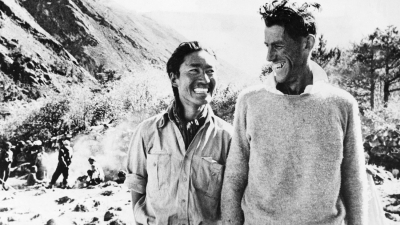
The Hillarys are the "first family" of Himalayan mountaineering with two generations of Everest climbers. When Peter Hillary, son of adventurer Sir Edmund Hillary, who, with mountaineer Tenzing Norgay, completed the first successful ascent of Mount Everest, climbed Everest in 1990, he and his father became the first father-son duo to achieve the feat. Peter has achieved two summits of Everest, an 84-day trek across Antarctica to the South Pole, and completed the Seven Summits, reaching the top of the highest mountains on all seven continents.

In 1960, Hillary organised the 1960–61 Silver Hut expedition,[60] with Griffith Pugh; and Pugh showed that Mount Everest could be climbed without oxygen, with a long period of acclimatisation by living at 20,000 feet (6,100 m) for six months. An assault on Makalu, the world's fifth-highest mountain, was unsuccessful. Hillary was with the expedition for five months, although it lasted for ten.

The expedition also searched for the fabled abominable snowman. No evidence of Yetis was found, instead footprints and tracks were proven to be from other causes. During the expedition, Hillary travelled to remote temples which contained "Yeti scalps"; however after bringing back three relics, two were shown to be from bears and one from a goat antelope. Hillary said after the expedition: "The yeti is not a strange, superhuman creature as has been imagined. We have found rational explanations for most yeti phenomena".

Picture Credit : Google

Krishna's Butter Ball – A Balancing Rock at Mahabalipuram

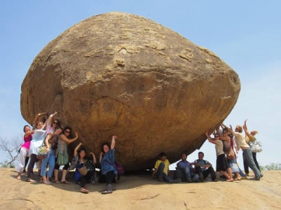
Krishna’s Buutterball in Mahabalipuram, Tamil Nadu, refuses to give in to gravity or the shoves of tourists! The giant granite boulder, six metres high and five metres wide, is perched on a slope, defying all laws of physics. Weighing around 250 tonnes, it is said to have been at the same place for 1200 years. It is part of the Group of Monuments at Mamallapuram built during 7th and 8th century CE by the Pallava Dynasty. The original name, Vaan Irai Kal, translates from Tamil as “Stone of Sky God”. According to Hindu mythology, Lord Krishna often stole butter from his mother’s butter handi; the big stone has been likened to a giant dollop of butter that the god dropped.

The rock’s awkward position makes it quite popular with locals and tourists alike as it makes for an interesting backdrop for some whacky photographs. It’s a common sight to see visitors placing hands under the stone posing for pictures, which looks as though they are holding it up. The rock provides welcome shade if you dare to sit underneath it, and local kids have discovered that the slippery nearby hillside also makes a great natural slide.

Mahabalipuram is an ancient historic town and was a bustling seaport during the time of Periplus (1st century CE) and Ptolemy (140 CE). Ancient Indian traders who went to countries of South East Asia sailed from the seaport of Mahabalipuram. Today's Mahabalipuram is purely a tourist town and one of the major attractions around Chennai. People visit this place to see the magnificent rock carvings, temples, cave sanctuaries, giant open-air reliefs such as the famous 'Descent of the Ganges', and the temple of Rivage, with thousands of sculptures to the glory of Shiva.

Picture Credit : Google