What is the height of the highest tsunami wave ever recorded?
The megatsunami in Spirit Lake, Washington, USA that was caused by the 1980 eruption of Mount St. Helens reached 260 metres (853 ft), while the tallest megatsunami ever recorded (Lituya Bay in 1958) reached a run-up height of 520 metres (1,720 ft).
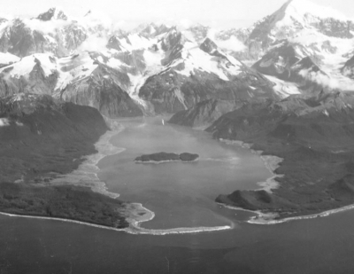
Lituya Bay is an ice-scoured tidal inlet on the northeast shore of the Gulf of Alaska. It is about seven miles long (11.3 kilometers) and up to two miles wide (3.2 kilometers). It has a maximum depth of about 720 feet (219 meters), but a sill of only 32 feet (9.7 meters) in depth separates it from the Gulf of Alaska between La Chaussee Spit and Harbor Point.
The Fairweather Fault trends across the northeast end of the Bay and is responsible for the T-shape of the bay. Glacial scour has exploited the weak zone along the fault to produce a long linear trough known as the Fairweather Trench. The Lituya Glacier and North Crillon Glacier have scoured portions of the Fairweather Trench in the area of Lituya Bay. Gilbert Inlet and Crillon Inlet occupy the Fairweather Trench on the northeast end of Lituya Bay.
The rockfall of July 9, 1958 occurred on steep cliffs above the northeast shore of Gilbert Inlet. It is marked on the map above in red. The rocks fell from an elevation of about 3000 feet (914 meters). The impact of 40 million cubic yards (30.6 million cubic meters) of rock hitting the water produced a local tsunami that swept the entire length of the Lituya Bay and over the La Chaussee Spit. This wave stripped all vegetation and soil from along the edges of the bay. This damaged area is shown in yellow on the map above. The numbers are elevations (in feet) of the upper edge of the wave damage area and represent the approximate elevation of the wave as it traveled through the bay.
Credit : Geology.com
Picture Credit : Google