WHAT ARE DESERTS?

Deserts are vast and extremely dry lands, which receive very little or no rainfall. They can be both hot and cold - in both cases, the amount of evaporation is higher than the precipitation received, and the land remains very dry.

A desert is a barren area of land where little precipitation occurs and consequently living conditions are hostile for plant and animal life. The lack of vegetation exposes the unprotected surface of the ground to the processes of denudation. About one third of the land surface of the world is arid or semi-arid. This includes much of the Polar Regions where little precipitation occurs and which are sometimes called “cold deserts”. Deserts can be classified by the amount of precipitation that falls, by the temperature that prevails, by the causes of desertification or by their geographical location.

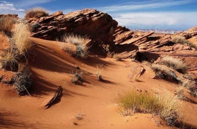
Deserts are formed by weathering processes as large variations in temperature between day and night put strains on the rocks which consequently break in pieces. Although rain seldom occurs in deserts, there are occasional downpours that can result in flash floods. Rain falling on hot rocks can cause them to shatter and the resulting fragments and rubble strewn over the desert floor is further eroded by the wind. This picks up particles of sand and dust and wafts them aloft in sand or dust storms. Wind-blown sand grains striking any solid object in their path can abrade the surface. Rocks are smoothed down, and the wind sorts sand into uniform deposits. The grains end up as level sheets of sand or are piled high in billowing sand dunes. Other deserts are flat, stony plains where all the fine material has been blown away and the surface consists of a mosaic of smooth stones. These areas are known as desert pavements and little further erosion takes place. Other desert features include rock outcrops, exposed bedrock and clays once deposited by flowing water. Temporary lakes may form and salt pans may be left when waters evaporate. There may be underground sources of water in the form of springs and seepages from aquifers. Where these are found, oases can occur.

Credit: Earth Science

Picture credit: Google

HOW DO GLACIERS SHAPE LAND?

The sheer weight and size of glaciers give them an enormous power to carve out the landscape. Much like mega bulldozers, they crush and grind everything that comes in their way, pushing the debris along until it is deposited in distinctive piles called moraine.

Glaciers are huge masses of ice that move across the land. ?Glaciers? are often called rivers of ice for the way they move down mountainsides and carve valleys. Though climate change is threatening glaciers today, there are still many glaciers changing landscapes around the world through erosion and material deposition. Glacial landforms left behind by glaciers include moraines, drumlins, troughs, aretes, horns and cirques.

There are three distinct ways that glaciers shape the land: 1) erosion 2) transportation and 3) deposition. Erosion picks up material through weathering through plucking and abrasion. That material is then transported as it moves downhill. Sometimes the material is hidden inside or at the base of the glacier, or sometimes it is on top of the glacier, accounting for the dirty color of some glaciers. Those rocks and other transported materials eventually get deposited to a new place as the glacier melts; this leftover material is called glacial till, and it's what forms many of our landscapes today from the last ice age!

Credit: labroots

Picture credit: Google

WHAT IS AN ALPINE GLACIER?

When they form in the high mountains, these rivers of ice are called alpine glaciers. They flow down through the mountains, cutting and breaking up the rocks, creating sharp peaks, ridges and gouging out unique, U-shaped valleys.

A glacier that is surrounded by mountains is called an alpine or mountain glacier. They are a persistent body of snow that moves under its weight at a slow pace. Alpine glaciers are a sheet of snow that forms over a cirque or high rock basin. The iceberg’s uppermost layer is brittle, but the ice beneath behaves like a plastic substance flowing gently.

The glacier usually forms in a cirque or high rock basin where snow accumulates throughout the year. The most amazing fact about this glacier is that the rate of accumulation at the upper surface balances the rate of evaporation and melting at the lower end.

The glacier begins to occupy a sloping valley situated in between the creeks or steep rock walls. Following that, the accumulation of snow occurs at the upper part of the bowl-shaped depression called a cirque.

The glacial ice starts flowing downwards, slowly abrading and plucking the bedrock. The accumulation of snow that is compacting and recrystallizing is called firn.

The flow then accelerates across the steep rock where the deep crevasses or gaping fractures mark the icefall. The lower part of the glacier denotes ablation. As the ice thins, it evaporates and melts, thereby losing its plasticity. There are chances of developing fissures, as the glacier tries depositing debris at the terminus when it melts.

Credit: EARTHECLIPSE

Picture Credit : Google