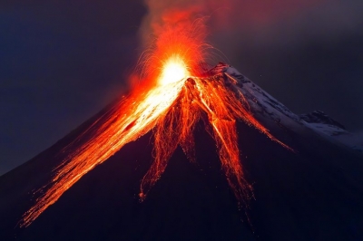
Which is the world’s largest, active volcano?

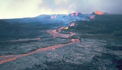
Mauna Loa is not only the world’s largest active volcano; it is also one of the tallest mountains on Earth! It originates deep beneath the Pacific Ocean and rises to more than 9,170 m from base to peak. This is higher than Mt. Everest, which is only 8,848 m.

Mauna Loa is one of the five volcanoes that form the island of Hawaii. It is an active shield volcano and the largest subaerial volcano both in mass and volume on Earth. It is a gently sloping mountain that takes up almost half of the land area of the island of Hawaii. It was created by a large number of fluid lava flows. Its dome is 120 km long and 103 km wide.

 Mauna Loa has erupted 33 times since 1843 but has not seen any eruptions since 1984. However, since March 2021, a series of small earthquakes have been recorded under Mauna Loa, indicating that perhaps this dormant volcano is waking up.

Picture Credit : Google

Why do volcanoes erupt?

A volcano is an opening in the Earth’s crust through which lava, volcanic ash and gases escape. This lava starts out as magma which originates beneath the Earth’s surface. Magma is a thick-flowing, molten rock mixture that, being lighter than the surrounding rock, rises and collects in magma chambers.

If a magma chamber experiences great pressure it may cause fissures or cracks in the Earth’s surface. The magma then erupts through these fissures and reaches the surface as lava. Many volcanoes sit over magma chambers.

Eruptions also happen when tectonic plates move or collide against one another or when one plate slides under another. The magma is squeezed out between the plates and rises up to erupt as a volcano.

Picture Credit : Google

How can we classify volcanoes?

Volcanoes are classified as extinct, dormant or active. An extinct volcano is one that has not had an eruption for at least 10,000 years and is not expected to erupt in the future. Kohala in Hawaii last erupted 120,000 years ago and is now an extinct volcano. Mt. Thielsen in Oregon, USA last erupted 250,000 years ago and is another extinct volcano.

A dormant volcano is an active volcano that is not erupting at present, but is expected to do so in the future. Mauna Kea in Hawaii is a dormant volcano. It last erupted around 4,000 years ago.

An active volcano is a volcano that has had at least one eruption in the last 10,000 years. An active volcano may be erupting or dormant. Mt. Kilauea in Hawaii is an active volcano. It last erupted in December, 2020.

Picture Credit : Google

What are volcanoes?

The Earth is made of three parts - Crust, mantle and core. The crust is the outer layer of the earth. It is about 5-70 km thick. This is the part we can see and live on. The mantle is the second layer under the crust. It is about 2,890 km thick. The innermost layer is called the core. It is mostly made of iron.

Between the Earth’s crust and mantle is a substance called magma which is made of molten rock and gases. When pressure in the molten rocks builds up, it escapes through fissures (narrow cracks in the earth’s crust) in the form of a volcano. Volcanoes are mostly formed by the movement of tectonic plates.

There are about 1,500 potentially active volcanoes in the world today. Many of these are positioned along the Pacific Ring of Fire, a horseshoe-shaped belt that extends around 40,000 km along South America, North America, the Bering Strait, Japan, Indonesia and New Zealand.

Volcanoes can be destructive but they are also of great use to us. Their explosive force brings minerals from deep within the earth to the surface. Geothermal energy is being harnessed from the internal heat of volcanoes. Volcanoes are therefore a productive force of nature.

Picture Credit : Google

Why are the Appalachian Mountains important?

The Appalachian Mountains are found in the north-eastern region of North America. They were formed around 480 million years ago and are one of the oldest mountains in the world. They extend almost 3,200 km from the Canadian province of Newfoundland to Alabama in the United States. Mt. Mitchell in North Carolina is the highest peak in the Appalachians at 2,037 m. The Appalachian Mountains are divided into three sections - Northern, Central and Southern.

The origins of the word Appalachian can be traced back to the remains of a native American village that was discovered in Tallahassee, Florida in 1528, which was called ‘Apalachen’. Did you know that in the early 19th century, Washington Irving proposed the name ‘Appalachia’ for the USA?

Picture Credit : Google

Why are the Ural Mountains important?

The Ural Mountains, or the Urals, are found in Russia and mark Europe’s eastern continental border with Asia. They were formed between 250 and 300 million years ago due to continental collisions.

These mountains form a natural divide between Europe and Asia and separate Russia into western Russia and eastern Russia. Western Russia lies in Europe and Eastern Russia, also called Siberia, lies in Asia.

The Urals are rich in mineral and metal deposits and are part of a highly developed industrial complex. They are divided into five sections. The Polar Urals, Subpolar Urals, Northern Urals, Middle Urals and the Southern Urals.

Picture Credit : Google

Why do we say that the beauty of the Rockies is well protected?

To protect the Rockies from commercial and economic exploitation, they have been divided into many national parks. This ensures that these mountains are protected with many controls in place regarding what may and may not be done in these areas.

These parks are known for their magnificent beauty and receive millions of visitors every year. Activities carried out here are done in harmony with nature and resorts and hotels use clean energy sources and encourage guests to be environment friendly.

One of the best known of these parks is the Yellowstone National Park in Wyoming, USA. At an elevation of 2,438 m, Yellowstone was the first national park to be established in the USA in 1872. Yellowstone’s natural forest cover extends nearly 9,000 sq km and comprises lakes, canyons, rivers and mountain ranges. It is home to 67 species of mammals including grizzly bears, wolves, bison and wapitis, as well as 300 species of birds and 6 species of reptiles.

It is centred on the Yellowstone caldera, the largest supervolcano on the continent. Yellowstone also has the world’s largest concentration of geysers. More than 300 geysers are found here, including ‘Old Faithful’ one of the most well-known geysers which has erupted every 44 minutes to 2 hours since 2000!

Picture Credit : Google

Where are the Rocky Mountains located?

The Rocky Mountains, or Rockies, are located on the western side of North America. They extend 4,800 km from the northern part of British Columbia in Canada to New Mexico in south-western United States. The Rockies have some of North America’s highest peaks.

The highest peak in the Rockies is Mt. Elbert in Colorado which is at an elevation of 4,401 m. It was first summited by Henry W Stuckle in 1874 and is often referred to as a ‘gentle giant’, as it is relatively easier to climb than other mountains in the same category.

The Rockies comprise at least 100 separate ranges and are divided into four sections. These are the Southern Rockies, found mainly in Colorado and New Mexico; the Middle Rockies found in Wyoming, Utah and south eastern Idaho; the Northern Rockies in Montana and north east Idaho; and the Canadian Rockies in British Columbia and Alberta.

Did you know that a super volcano lies hidden in the Rocky Mountains? The volcano is located in the Yellowstone National Park and is called the Yellowstone Caldera. This is one of the reasons why you can see geysers in Yellowstone, and why there is an overpowering smell of phosphor in the air throughout the national park.

Picture Credit : Google

Why does the climate in the Rockies vary greatly?

The Rockies have a cold steppe climate with everlasting snow in the higher areas. The weather can change rapidly depending on altitude and latitude of the region. The windward side gets more rain than the leeward side. In general the summers are warm and dry but mountain rain and thunderstorms can occur, while winters are very cold with a lot of rain and snow.

Climate in the Rockies varies from the frozen wastelands of Alaska in the north to sunny Mexico in the south. The Rockies affect the climate of the North American continent by acting as a barrier to rain bearing winds. As a result, in the south the climate tends to be dry, especially in the rain-shadow valleys. The San Luis Valley in Colorado, for example, has a mountain-desert climate and is one of the driest areas of the Rockies. The Northern Rockies tend to receive rain and snow more evenly throughout the year from Pacific cyclonic storms.

Picture Credit : Google

What is the climate of the Alps like?

The unique location of the Alps allows for the interplay of several factors that have resulted in huge variations in climate here. Different types of winds converge and play a prominent role in the daily weather and microclimate conditions of the Alps.

Four kinds of wind influence the climate on the Alps. Mild, moist air of the Atlantic pours in from the west. Cool polar air blows down from northern Europe. Continental air masses, that are cold and dry in winter and hot in summer, play a big role in the eastern regions of the mountains, and from the south, warm Mediterranean air flows northward into the Alps.

Daily weather on the Alps is also influenced by the location and passage of cyclonic storms, as well as the direction of the winds as they pass over the mountains.

The Alps are split into 5 climatic zones in which the weather varies: The colline zone lies between 500 m and 100 m. The montane zone lies between 800 m and 1.700 m. The sub-alpine zone is found between 1,600 m and 2,400 m, while the alpine zone extends from the treeline to the snowline. The glacial zone covers the glaciated areas of the mountains.

Picture Credit : Google

Which are the notable mountains in the Alps?

The Alps are the longest and highest mountain range in Europe. The name Alps most likely comes from the Latin word ‘albus’ which means ‘white’. These mountains have 82 official summits of 4,000 m and above. All these peaks, also referred to as ‘four-thousanders’, are located within France, Italy or Switzerland.

The highest of the four-thousanders is Mont Blanc which rises to 4,807 m. Mont Blanc means White Mountain, both in French and Italian. It is named so because it is covered in heavy snow all year round. Mont Blanc is part of the Mont Blanc massif (group of mountains) which contains eleven major independent summits, each over 4,000 m in height. Mont Blanc was first summited in 1786 by Jacques Balmat and Michel-Gabriel Paccard.

Monte Rosa lies between Italy and Switzerland. At 4,634 m, it is the second highest mountain in the Alps and the highest in the Swiss Alps, which has 10 peaks higher than 4,000 m. Monte Rosa was first summited in August 1855 by a group of alpinists.

Another notable mountain is the Matterhorn. It lies on the border between Italy and Switzerland and is Switzerland’s most famous mountain. At 4,478m the Matterhorn is one of the highest mountains in the Alps. The mountain’s four sides face the four cardinal directions- north, south, east and west. It was first summited in 1865 by a group of mountaineers. Around 500 alpinists have died trying to climb the Matterhorn, making it one of the deadliest peaks in the world.

Jungfrau, which falls in Switzerland, is one of the main summits of the Bernese Alps (Jungfrau’s parent range). The mountain is 4,158 m tall and is located between the northern Canton of Bern and the southern Canton of Valais. Jungfrau was first summited in August 1811 from the eastern side by two Swiss brothers named Rudolf and Hieronymus Meyer.

Picture Credit : Google

How were the Alps formed? Why is it said that the Alps boast of an incredibly complex topography?

Millions of years ago, the map of the world was very different. There were different land masses and different water bodies on the Earth. One such water body was called the Tethys Ocean. A part of this ancient and mighty ocean lay between Africa and Europe.

Around 180 million years ago, the continent of Africa began slowly pushing into southern Europe. This caused the Tethys Sea to drain away in that region and the underlying seabed was lifted up along with parts of the Earth’s crust to form the Alps.

This process took many millions of years and the Alps are still growing to this day, as movements of the Earth’s crust continue, pushing them upwards bit by bit.

The Alps are the highest mountains in Europe with a variety of elevations and shapes. They exhibit an incredibly complex topography with majestic peaks, lakes, glaciers, waterfalls and ice-scoured valleys cradling alpine forests and pristine meadows.

Picture Credit : Google

Why are the Alps known as ‘Europe’s playground’?

Before the mid-19th century the economy of the Alps was mostly agricultural and pastoral based. After World War II, many tourists began flowing into the Alps. The Alps provided a beautiful and spectacular setting to shake off the horrors of war and indulge in the beauty of nature.

Over the years tourism has become the central activity in the Alps. The pristine, snow-covered slopes attract skiers by the thousands. Forest trails for hikers, swift flowing rivers for river rafting, craggy peaks for rock climbing, lakes for boating and swimming all lead to a heavy influx of tourists to the Alps. So much so, that the Alps have become a summer and winter playground for millions of Europeans and tourists from around the world.

Around 120 million tourists visit the Alps every year and this is resulting in many changes in the Alps. Forests and slopes have been cleared of trees, resorts are being built, roads are being cut through the mountains and adventure sports enthusiasts like hikers, bikers, skiers, paragliding and boating enthusiasts and mountaineers are leaving behind a huge carbon footprint. The increasing urban sprawl has led to pollution of the soil, water and air, loss of habitat and a direct threat to biodiversity in the Alps.

Picture Credit : Google

Which is the highest mountain in the Andes Mountain Range?

Mt. Aconcagua at a height of 6,961 m is the highest mountain in the Andes Mountain Range and also in the western and southern hemispheres. It is located in Argentina, in the province of Mendoza and lies 15 km from the border of Chile.

Aconcagua is one of the ‘Seven Summits’. The Seven Summits are the highest mountains on each of the seven continents. Climbing to the summit of all of them is regarded as a mountaineering feat, which was first achieved by Richard Bass from the USA in 1985.

The name Aconcagua is believed to mean ‘sentinel of stone’ in Quechua. Aconcagua used to be an active volcano till about 10 million years ago. It is part of the Aconcagua Provincial Park, a protected natural area in the Andes that was established in 1983. It has a number of glaciers, the largest of which is Ventisquero Horcones Inferior which is about 10 km long.

Aconcagua was first climbed in 1897 by Swiss mountaineer, Matthias Zurbriggen. The youngest person to reach the summit was Tyler Armstrong of USA. He was 9 when he reached the summit in December 2013.

Kamya Karthikeyan from India became the youngest girl to reach the summit in February 2020.

Picture Credit : Google

Where are the Alps located?

The Alps are located in the southern part of central Europe. These crescent-shaped mountains stretch for 1,200 km across the countries of Italy, Switzerland, France, Germany, Liechtenstein, Monaco, Slovenia and Austria.

The Alps lie north of the Mediterranean Sea and begin near Monaco on the coastline of southern France and extend into Switzerland, northern Italy, Germany and Vienna in Austria. The mountains continue downwards through the countries of Slovenia, Croatia, Bosnia and Herzegovina, Serbia, and Montenegro before ending in Albania on the rugged Adriatic Sea coastline.

The Alps are divided into Western, Central and Eastern segments, each of which consists of distinct ranges.

The Western Alps extend north from south-eastern France and north-western Italy to Lake Geneva and the Rhone Valley in Switzerland. The highest peak in the Alps, Mont Blanc, which rises to 4,807 m, lies in this region.

The Central Alps occupy an area from the Great St. Bernard Pass east of Mont Blanc on the Swiss-Italian border, to the region north of Splugen Pass. The great glacial lakes of Como and Maggiore fall in this region.

The Eastern Alps consist of the Dolomite Alps in Italy, the Bavarian Alps of southern Germany, the Tauern Mountains in Austria, the Julian Alps in north-eastern Italy and the Dinaric Alps along the Balkan Peninsula.

Picture Credit : Google