Which river is largely referred to as Tsangpo throughout its upper case?


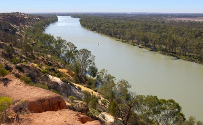
The Brahmaputra called Yarlung Tsangpo in Tibet, Siang/Dihang River, in Arunachal Pradesh and Luit, Dilao in Assam, is a trans-boundary river which flows through Tibet, India and Bangladesh. It is the ninth largest river in the world by discharge, and the 15th longest.


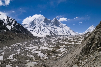
The BrahmaputraRiver originates in the Chemayungdung mountain ranges which nearly sixty miles south-east of Mansarovar lake in the MountKailash range in Southern Tibet at an elevation of 5300 m.A spring called Tamchok Khambab spills from the glaciers which later gather breath and volume to become the Tsangpo, the highest river in world.


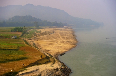
Apart from the name Tsangpo, the Brahmaputra is also known by its Chinese name, Yarlung Zangbo in Tibet.  There are several tributaries of Tsangpo in Tibet. Before entering India, the river passes Pi (Pe) in Tibet and suddenly turns to the north and northeast and cuts a course through a succession of great narrow gorges between the mountain Gyala Peri and Namjabarwa (Namcha Barwa) in a series of rapids and cascades.


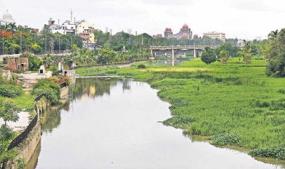
In India the total basin area of BrahmaputraRiver is 197 316 sq. km. which 5.9% of the total geographic area of the country. In India the river is spread over states of Arunachal Pradesh, Assam, West Bengal, Meghalaya, Nagaland and Sikkim.


Picture Credit : Google


The Harappan civilization flourished around which river valley?


The Harappan civilization was located in the Indus River valley. Its two large cities, Harappa and Mohenjo-daro, were located in present-day Pakistan’s Punjab and Sindh provinces, respectively. Its extent reached as far south as the Gulf of Khambhat and as far east as the Yamuna (Jumna) River.


Before the excavation of these Harappan cities, scholars thought that Indian civilization had begun in the Ganges valley as Aryan immigrants from Persia and central Asia populated the region around 1250 BCE. The discovery of ancient Harappan cities unsettled that conception and moved the timeline back another 1500 years,situating the Indus Valley Civilization in an entirely different environmental context.


The Indus River Valley Civilization is considered a Bronze Age society; inhabitants of the ancient Indus River Valley developed new techniques in metallurgy—the science of working with copper, bronze, lead, and tin. Harappans also performed intricate handicraft using products made of the semi-precious gemstone Carnelian.


Picture Credit : Google


On which river bank is the Taj Mahal situated?


 The Taj Mahal was built on the banks of the river Yamuna, between 1631 and 1643, by the Mughal emperor Shah Jahan as a mausoleum for his beloved wife Arjumand Banu Begum, who was also known by the title Mumtaz Mahal. 


The Taj Mahal was designated as a UNESCO World Heritage Site in 1983 for being "the jewel of Muslim art in India and one of the universally admired masterpieces of the world's heritage". It is regarded by many as the best example of Mughal architecture and a symbol of India's rich history. The Taj Mahal attracts 7–8 million visitors a year and in 2007, it was declared a winner of the New 7 Wonders of the World (2000–2007) initiative.


The Taj Mahal incorporates and expands on design traditions of Persian and earlier Mughal architecture. Specific inspiration came from successful Timurid and Mughal buildings including the Gur-e Amir (the tomb of Timur, progenitor of the Mughal dynasty, in Samarkand), Humayun's Tomb which inspired the Charbagh gardens and hasht-behesht (architecture) plan of the site, Itmad-Ud-Daulah's Tomb (sometimes called the Baby Taj), and Shah Jahan's own Jama Masjid in Delhi. While earlier Mughal buildings were primarily constructed of red sandstone, Shah Jahan promoted the use of white marble inlaid with semi-precious stones. Buildings under his patronage reached new levels of refinement.


Picture Credit : Google


Which is the last Indian State the Himalayan River Ganges enters before flowing into Bangladesh and eventually into the Bay of Bengal?


 West Bengal is the last Indian state that the Ganges enters, and, after it flows into Bangladesh, the Mahananda River joins it from the north. In West Bengal in India, as well as in Bangladesh, the Ganges is locally called the Padma. The westernmost distributaries of the delta are the Bhagirathi and the Hugli (Hooghly) rivers, on the east bank of which stands the huge metropolis of Kolkata (Calcutta). The Hugli itself is joined by two tributaries flowing in from the west, the Damodar and the Rupnarayan. As the Ganges passes from West Bengal into Bangladesh, a number of distributaries branch off to the south into the river’s vast delta. In Bangladesh the Ganges is joined by the mighty Brahmaputra (which is called the Jamuna in Bangladesh) near Goalundo Ghat. The combined stream, there called the Padma, joins with the Meghna River above Chandpur. The waters then flow through the delta region to the Bay of Bengal via innumerable channels, the largest of which is known as the Meghna estuary.


The rivers in the West Bengal area are sluggish; little water passes down them to the sea. In the Bangladeshi delta region, the rivers are broad and active, carrying plentiful water and connected by innumerable creeks. During the rains (June to October) the greater part of the region is flooded to a depth of 3 or more feet (at least 1 metre), leaving the villages and homesteads, which are built on artificially raised land, isolated above the floodwaters. Communication between settlements during that season can be accomplished only by boat.


Picture Credit : Google


Which is the longest river in Australia?


The calculations confirmed that Australia's longest single river is the River Murray at 2508 kilometres. However, if the longest tributaries of the Darling River, the Culgoa, Balonne and Condamine, are taken into account its total length increases to 2740 kilometres, making it Australia's longest waterway.


The National Topographic Database is a nationally consistent dataset containing a range of topographic features, such as relief and drainage, which has been captured and maintained at a scale of 1:250 000 for the whole of Australia. Use of the database to digitally calculate the longest rivers has resulted in more precise estimates than those available previously.


The Murray River was first discovered by European explorers Hamilton H. Hume and William H. Hovell in 1824. It wasn't until five years later, however, that Charles Sturt navigated down the Murrumbidgee to encounter the Murray and named it after Sir George Murray, (Soldier and Tory Party Politician 1772-1846) when his exploration party encountered the Darling connection. Sturt had previously explored the Darling River to the north and was able to determine that they were indeed the same river system.


The Murray River is the world's 16th-longest river at 2,520 kilometres from its source in the Kosciusko National Park. It is fed by several rivers on it's journey from the Australian Alps. The main feeding rivers are the Darling and Murrumbidgee Rivers. The Darling River (2,740 kilometres) begins in the far inland of Australia (Queensland) and joins the Murray at Wentworth (NSW) then flows to the Southern Ocean through South Australia.


Picture Credit : Google


Which is the longest river in Europe?


The Volga is the longest river in Europe; its source is in the Valdai Hills, in a town known as Volgo-Verjovie, between the cities of Moscow and Saint Petersburg, at about 228 metres above sea level. With approximately 200 tributaries, the main ones are the Kama, Samara, Oka, Vetluga and Sura rivers.


The Volga has many tributaries, most importantly the Kama, the Oka, the Vetluga, and the Sura rivers. The Volga and its tributaries form the Volga river system, which drains an area of about 1.35 million square kilometres in the most heavily populated part of Russia. The Volga Delta has a length of about 160 kilometres and includes as many as 500 channels and smaller rivers. The largest estuary in Europe, it is the only place in Russia where pelicans, flamingoes, and lotuses may be found. The Volga freezes for most of its length during three months of each year.


The Volga drains most of Western Russia. Its many large reservoirs provide irrigation and hydroelectric power. The Moscow Canal, the Volga-Don Canal, and the Mariinsk Canal systems form navigable waterways connecting Moscow to the White Sea, the Baltic Sea, the Caspian Sea, the Sea of Azov and the Black Sea. High levels of chemical pollution currently give cause for environmental concern.


The fertile river valley provides large quantities of wheat, and also has many mineral riches. A substantial petroleum industry centres on the Volga valley. Other minerals include natural gas, salt, and potash. The Volga Delta and the nearby Caspian Sea offer superb fishing grounds. Astrakhan, at the delta, is the centre of the caviar industry.


Picture Credit : Google


Which is the longest river in Antarctica?


The Onyx River is the longest river in Antarctica, flowing for 19 miles from the coastal Wright Lower Glacier and ending in Lake Vanda. 


The Onyx River, in Wright Valley, is a seasonal stream of meltwater which flows for some 40 km from coastal piedmont glaciers inland into Lake Vanda. The stream bed is mainly braided in fine alluvial gravels, with some stretches of coarser moraine materials. A number of tributary feeders flow from the alpine glaciers of the ranges bordering the valley. Seasonal flows have been regularly monitored from two portions of the river. The Lower Wright site, close to the headwaters of the river, is about 2 km downstream from the shallow Lake Brownworth at the terminus of the Lower Wright Glacier. It is upstream from the confluence with the tributary streams and hence records only the flow contribution from the Lower Wright Glacier. The Vanda Weir is about 500 m upstream from the mouth of the river at Lake Vanda and also contains water from the Clark, Meserve and Bartley glacier streams.


There are no fish in the Onyx River, but it supports microscopic life, and the algal blooms can be quite extensive. The environment consists mainly of cyanobacteria and other algae. A few small animals (nematodes, tardigrades, and rotifers) live in the river. Skuas are also occasionally present in the area.


Picture Credit : Google


Which is the longest river in North America?


The Missouri is the longest river in the US – North America. The Missouri flows entirely though the United States, where it crosses seven states: Montana, North Dakota, South Dakota, Nebraska, Iowa, Kansas and Missouri.


The headwaters of the Missouri are located where the Jefferson, Madison and Gallatin rivers meet, in the Rocky Mountains, in Montana, 1,200 metres above sea level. It flows into the Mississippi river as its main tributary, 16 kilometres from the city of St. Louis.


The Missouri is 3,943 kilometres long. If we consider the Mississippi-Missouri river system, the total length would increase to 7,725 kilometres, forming the world’s fourth longest river, after the Amazon, Nile and Yangtze rivers.


The drainage basin spans 1,371,100 square kilometres, making it the sixth largest one in the world, comprising 16,840 square kilometres in southern Canada.


For thousands of years, the Missouri has been home to Native Americans. The first Europeans to discover the river were explorers Jacques Marquette and Louis Jolliet in 1673. After that, explorers Lewis and Clark (1804-1805) were the first to navigate from its headwaters to its mouth.


During the 19th century, steam boat traffic increased until 1858, when it started to decline. In 1944, the US Congress approved a programme for irrigation development, flood control, and hydropower generation.


Picture Credit : Google


Which is the longest river in Africa?


The Nile is the longest river in Africa and the second longest river in the world, with 6,695 kilometres. Its basin spans 3,349,000 square kilometres, approximately 10% of the surface area of Africa.


The Nile river flows through a significant portion of the African continent and has generated numerous ecological relationships among the different populations, with broad ethnic diversity.  In addition, the Nile river is used as a waterway for transport, and in some areas such as South Sudan, travelling is only possible through the Nile between the months of May and November, because of flooding.


It is also responsible for carrying water from the Nile’s furthest source. The section known as Kagera starts in Burundi and it flows out of Lake Rweru through the Burundi-Rwanda and the Tanzania-Rwanda borders to convergence with river Ruvubu. From the confluence, it flows over the Rusumo falls, through the Akagera National Park before turning east and flowing into Lake Victoria. Akagera River is fed by Ruvubu from Burundi and Nyabarongo from Rwanda.


Picture Credit : Google


Which is the longest river in South America?


South America boasts no shortage of great rivers. The Madeira River stretches some 3,250 kilometres and the Parana dwarfs it at 4,880 kilometres. Most impressive of all is the longest river in South America is the Amazon River.


The most distant source of the Amazon is the Mantaro River in Peru. The Mantaro joins with other tributaries to form river Ucayali which meets with river Maranon to create the primary stem of the Amazon. The River Ene forms at the confluence of the River Apurimac and the River Mantaro, and it is part of the Amazon river’s headwaters which originates from Mismi. After about 450 miles, the Apurimac meets with river Mantaro and becomes Ene which joins River Perene and becomes river Tambo which drains to Ucayali. Ucayali-Tambo-Ene and Apurimac join the Amazon to form the longest river in the world. The Amazon has an average discharge of 209 million liters per second. The river's discharge represents about 20% of the world flow into the ocean. The Amazon River passes through multiple countries including Venezuela, Guyana, Ecuador, Colombia, Bolivia, Peru and Brazil.


Naturally, the longest river in South America is a source of food and water for the great Amazon rainforest. It’s thought that around a third of all known species live in the rainforest, including jaguars, ocelots and sloths. It’s not all about the rainforest, though. The river itself has plenty of weird and wonderful creatures of its own. Spend a little time on the Amazon river and you might be fortunate enough to encounter the Amazon river dolphin, the Amazonian manatee and the giant otter. If you’re unfortunate, you may stumble upon an anaconda, among the largest snakes in the world and known to hunt in the river’s shallow waters.


Which is the longest river in Asia?


The Yangtze River in China is the longest river in Asia, the third longest river in the world and the longest river to flow entirely in one country. The river begins its journey in the glacial meltwaters of the Tanggula Mountains in Tibet and flows approximately 3,915 miles (6,300 kilometers) until it empties in the East China Sea near the city of Shanghai. The river flows through or borders 10 provinces. 


The river flows through a variety of terrains, including high plateaus and lowland plains, but most of its journey — approximately three-fourths of it — is spent passing through mountainous regions, including some extremely scenic areas with deep valleys, canyons and gorges. The river is fed by approximately 700 tributaries, including eight principal rivers: Yalung, Min, Jialing, Han, Wu, Yuan, Xiang and Gan rivers.


The Yangtze River basin is considered the great granary of China. The economy of the basin focuses largely on agriculture, according to Encyclopaedia Britannica. The grains produced here -- 70 percent of which is rice -- is enough to feed half of the country's population, according to Travel China Guide. Other crops grown here include barley, cotton, wheat, corn and beans.


Picture Credit : Google


On which river bank did the Battle of the Hydaspes happen?


Battle of the Hydaspes, (326 BCE), fourth and last pitched battle fought by Alexander the Great during his campaign of conquest in Asia. The fight on the banks of the Hydaspes River in India was the closest Alexander the Great came to defeat. 


The battle took place on the east bank of the Hydaspes River (now called the Jhelum River, a tributary of the Indus River) in what is now the Punjab Province of Pakistan. Alexander later founded the city of Nicaea on the site; this city has yet to be discovered. Any attempt to find the ancient battle site is complicated by considerable changes to the landscape over time. For the moment, the most plausible location is just south of the city of Jhelum, where the ancient main road crossed the river and where a Buddhist source mentions a city that may be Nicaea. The identification of the battle site near modern Jalalpur/Haranpur is certainly erroneous, as the river (in ancient times) meandered far from these cities.


Alexander had to subdue King Porus in order to keep marching east.[citation needed] To leave such a strong opponent at his flanks would have endangered any further exploits. Alexander could not afford to show any weakness if he wanted to keep the loyalty of the already subdued Indian princes. Porus had to defend his kingdom and chose the perfect spot to check Alexander's advance. Although he lost the battle, he became the most successful recorded opponent of Alexander.


Picture Credit : Google


In which country does River Kwai flow?


The River Kwai, more correctly ‘Khwae Noi’ or Khwae Sai Yok is a river in western Thailand, near, but not over the border with Myanmar. It begins at the confluence of Ranti, Songkalia and Bikhli Rivers. 


The river is chiefly known from the Pierre Boulle novel and David Lean film The Bridge on the River Kwai, in which Australian, Dutch and British prisoners of war were forced by the Japanese to construct two parallel bridges spanning the river as part of the Burma Railway, also called the Death Railway, for the many lives lost in its construction. One bridge was wooden and temporary. The other was made of concrete and steel and still exists. The bridges actually spanned the Mae Klong, but as the railway subsequently follows the Khwae Noi Valley, the bridges became famous under the wrong name. In the 1960s, the upper part of the Mae Klong was renamed the Khwae Yai (big tributary”).


River Kwai Noi also runs through a national park, Saiyok National Park. The park’s area is approximately 500 square kilometers. Its landscape and scenery are arguably the most beautiful places in Thailand where once the famous Death Railway passed though Sai Yok Noi. The park’s major attractions are its waterfalls, including Sai Yok Yai waterfall which flows into the Khwae Noi river (River Kwai Noi).


Picture Credit : Google


Why is the Yellow River often referred to as "China's Sorrow"?


The Yellow River is also called "China's Sorrow". Each year, over 1.6 billion tons of soil flows into the Yellow River, which causes the continual rise and shift of the riverbed. Before damming, it was extremely prone to flooding, and had caused millions of deaths, including the deadliest disaster in human history.


With global warming, decrease in rainfall in the Yellow River Basin, and increasing water demands for irrigation, industry, etc., the Yellow River has been used up by its lower reaches since 1972, when it ran dry for the first time in recorded history. The longest dry period lasted 226 days in 1997.


Drought in the Yellow River region has brought serious challenges to agricultural development and the cities near the Yellow River.


What's worse, the river has been abused. It has become so polluted in some reaches that it is unfit for agricultural and industrial use, because of the huge increase in factory and sewage discharges from China's fast-expanding cities.


The government is taking measures to deal with Yellow River pollution, such as setting limits on the volume of major pollutants discharged into rivers and lakes, and controlling overuse of water resources.


Picture Credit : Google


The 1908 flooding of which river divides Hyderabad into the historic old city and the new city?


As Kerala grapples with a deluge of unimaginable proportions, the second time in under 100 years, it is interesting to remember the Hyderabad experience. Around 110 years ago on September 26, 1908, it began to rain in the surrounding areas of Hyderabad as a result of a cyclone in the Bay of Bengal. Over the next 48 hours, the downpour continued in the Musi river basin logging 98.57 cm rainfall. Of the 788 tanks and lakes in the river basin, 221 breached due to the cloudburst. 


According to historian Benjamin Cohen, the flood and deaths were used by the Nizam and his advisers to remake the city in a way that made it flood-proof. It also changed the power equations of the city.


Picture Credit : Google