What are National Monuments?


Around the world, thousands of buildings, statues, and parks helps us remember the past and honour people who made a difference in the world. These places are called national monuments.


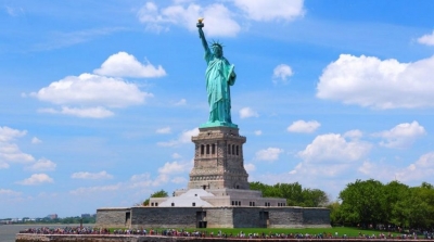
One of the world’s famous monuments is the Statute of Liberty in New York Harbor, U.S.A. This majestic copper sculpture of a woman holding a torch towers 46 metres. A stairway inside the statue lets visitors look through Liberty’s crown. For immigrants who enter the U.S.A. through New York Harbor, the statue is a symbol of freedom and opportunity. The statue was a gift from France to the U.S.A. in 1885.


At Dinosaur National Monument in the U.S.A., tourists can see fossils of prehistoric reptiles. This national monument in Colorado and Utah also has canyons cut by the Green and Yampa rivers.


One of the greatest battles ever won by the British navy is remembered with a huge statue of Admiral Horaito Nelson in Trafalgar Square in London, England. Nelson was killed in the battle, but his statue has become one of the world’s famous landmarks.


In the centre of Hiroshima, Japan, a huge sculpture stands near the ruins of a building destroyed during a nuclear bomb attack. The ruined building, and the sculpture, known as the Atomic Bomb Dome, a part of Peace Memorial Park. The monument serves as a reminder of the atomic bomb that was dropped on the city during World War II.


Picture Credit : Google


How people of different continents are connected to each other?


The seven continents are far apart from each other, but they are all part of the earth. No matter how far apart the continents are, the people who live on them are connected because they have the same needs. In addition to needing food, clothing, and a place to live, they all need to learn, to communicate, and to plan for the future.


Years ago, people knew very little about the continents. The only way they could learn about them was by travelling on ships. Today, TV’s and computers send information around the world with the flick of a switch or the click of a mouse. People watching TV in Australia can see a person rafting down the Amazon River in South America. A scientist in North America can send an instant message to a scientist in Antarctica by computer.


Yes, the continents are very far apart. But transport and technology have brought the people who live on them much closer together.


Picture Credit : Google


Which is the largest lake in Australia?


Lake Eyre, officially named Kati Thanda-Lake Eyre, is a large salt water lake in South Australia. The lake derives its name from the first European to discover it, Edward John Eyre. Lake Eyre is mostly dry, but when filled it becomes the largest lake in Australia, occupying an area of 3668 square miles. When Lake Eyre is filled with water, and it springs to life, providing a habitat for migratory birds such as pelicans and sea plants. Lake Eyre falls under two protected areas: Elliot Price Conservation Park and Kati Thanda-Lake Eyre National Park. The South Australian government protects the area surrounding the lake.


The water entering Lake Eyre comes mostly from the rivers from the northeast (in Queensland), which flow down from the Channel Country. A smaller amount of water comes down from Northern Territory from the Finke River catchment, via the Macumba River.


Generally, it takes around 6-8 weeks for water from the Channel Country to reach the lake.


One of the more disturbing facts is that as water fills the lake, the salinity increases and causes a massive fish kill. (Yes, there are about 6 or 7 species of fish which live in the lake!).


Once the lake is full, however, it’s no more salty than the sea. As the lake dries up and the water evaporates, its salinity increases again.


During this time Lake Eyre often appears to turn ‘pink’. This is in fact caused by a pigment found within an algae species that lives in the lake.


Picture Credit : Google


Which is the largest lake in Europe?


Ladoga is by far Europe’s largest lake with a total surface area of 17 700 square kilometers (6,800 sq mi), which means that it’s larger than both Onega and Vänern combined. 


It’s beautifully located in Karelia in the northwestern part of Russia. Ladoga is ranked as one of the largest lakes in the world (14th) and has an average depth at 51 meters, and maximum depth at 230 meters. 


Visitors can rent a boat to get around the lake and stop for a picnic at one of the 600 islands that are located within its boundaries.


Lake Ladoga famously serves as a source of drinking water for the city. Renowned vodka brand Russian Standard even uses it to create the nation’s favourite tipple (the word vodka is a diminutive of the Russian ‘voda’, meaning water); the company’s vodka scientists go as far as describing the lake water as ‘being alive’.


History aside, Lake Ladoga is a wonder of Nordic beauty, characterized by dense forests and rocky coastlines that can be explored by boat or on foot. The lake boasts an incredibly diverse ecosystem, with nearly 500 species of fish roaming its waters, including carp, bream, perch, and the endangered Atlantic sturgeon, whose eggs are used to make premium caviar.


Picture Credit : Google


Which is the largest lake in Antarctica?


Antarctica is the world's southernmost continent and is located almost completely south of the Antarctic Circle. It is also the coldest, driest, and windiest continent, and approximately 98% of Antarctica is covered by ice that has an average thickness of nearly 2 km. Despite being largely covered in ice, Antarctica contains numerous lakes and rivers. Many of these lakes are subglacial. The largest of the 400 known subglacial lakes in Antarctica is Lake Vostok, which is located beneath Vostok Station, a Russian research station in Prince Elizabeth Land, Antarctica. Lake Vostok is a freshwater lake situated approximately 4,000 m beneath surface of the ice sheet, which means it is approximately 500 m below sea level.


Lake Vostok was most likely sealed off by a thick ice sheet approximately 15 million years ago. Researchers initially believed the same water had been in the lake since its formation. However, researchers Robin E. Bell and Michael Studinger from Columbia University's Lamont-Doherty Earth Observatory later proved that the lake's water was continually freezing and getting carried away by moving ice sheets, and then replaced by water created through the cumulative pressure of the ice sheets. As a result, the entire lake water is replaced approximately every 13,300 years.


Picture Credit : Google


Which is the largest lake in South America?


Lake Titicaca is the largest lake in South America by surface area and volume. It covers an area of 3,232 sq mi and holds an average of 214 cu mi of water. It is the world’s "highest navigable lake” at an altitude of 12,507 ft. Titicaca is located within the boundaries of two countries; the western part lies in Puno Region of Peru while the eastern part is located in the Bolivian La Paz Department. The lake consists of two basins connected by the Strait of Tiquina. Five major rivers and more than 20 streams feed Titicaca; the Río Desaguadero is the only outlet. There are 41 islands on the lake most of which are inhabited.


The lake averages between 460 and 600 feet (140 and 180 m) in depth, but the bottom tilts sharply toward the Bolivian shore, reaching its greatest recorded depth of 920 feet (280 m) off Isla Soto in the lake's northeast corner.


More than 25 rivers empty their waters into Titicaca; the largest, the Ramis, draining about two-fifths of the entire Titicaca Basin, enters the north-western corner of the lake. One small river, the Desaguadero, drains the lake at its southern end. This single outlet empties only 5 percent of the lake's excess water; the rest is lost by evaporation under the fierce sun and strong winds of the dry Altiplano.


Picture Credit : Google