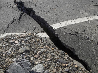
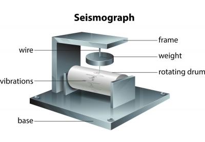
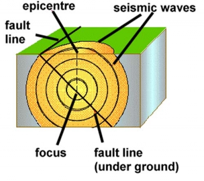
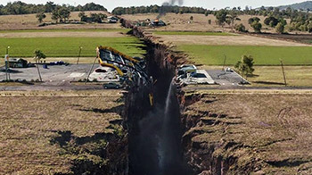
What is the history of big earthquakes after 2000?


Southern Peru 2001


The 2001 southern Peru earthquake occurred at 20:33:15 UTC (15:33:15 local time) on June 23 with a moment magnitude of 8.4 and a maximum Mercalli intensity of VIII (Severe).


At least 74 people were killed, including 26 killed by a tsunami. At least 2,687 were injured, 17,510 homes were destroyed and 35,549 homes damaged in the Arequipa-Camana-Tacna area. An additional 64 people were missing due to the tsunami in the Camana-Chala area. Landslides blocked highways in the epicentral area. Many of the historic buildings in Arequipa were damaged or destroyed, including the left tower of the Basilica Cathedral of Arequipa.


Denali 2002


The 2002 Denali earthquake occurred at 22:12:41 UTC (1:12 PM Local Time) November 3 with an epicenter 66 km ESE of Denali National Park, Alaska, United States. This 7.9 Mw earthquake was the largest recorded in the United States in 37 years (after the 1965 Rat Islands earthquake). 


Minor damage was reported over a wide area but the only examples of severe damage were on highways that crossed the fault trace and areas that suffered liquefaction, e.g. Northway Airport. Several bridges were damaged but none so severely that they were closed to traffic.


Hokkaid? 2003


The 2003 Hokkaid? earthquake, scientifically named the 2003 Tokachi-Oki earthquake, occurred off the coast of Hokkaid?, Japan on 26 September at 04:50 local time.


 The tremor affected a total of 36 local rivers, including the major Abashiri and Ishikari Rivers. Many properties received considerable damage, and although there were no deaths, 849 people sustained injuries.


Sumatra 2004


Ans: This massive earthquake had a force of 9.3! It triggered a series of huge waves, called for thousands of kilometers across the Indian Ocean, killing 280,000 people. The resulting tsunami affected 12 nations around the Indian Ocean, with Indonesia suffering the greatest damage. In Aceh, the northern province of Sumatra, the United Nations (UN) Field Office reported approximately 131,000 people confirmed dead and 37,000 missing. With more than 80,000 houses sustaining major damage or collapse, the UN estimated that more than 500,000 people were displaced from their homes in Sumatra alone. In addition to the massive damage to housing, utilities, roads, and bridges, the disaster significantly disrupted the social fabric and government of the affected communities.


Nias–Simeulue 2005


The 2005 Nias–Simeulue earthquake occurred on 28 March off the west coast of northern Sumatra, Indonesia. At least 915 people were killed, mostly on the island of Nias. The event caused panic in the region, which had already been devastated by the massive tsunami triggered by the 2004 Indian Ocean earthquake, but this earthquake generated a relatively small tsunami that caused limited damage. It was the third most powerful earthquake since 1965 in Indonesia.


On the Indonesian island of Nias, off the coast of Sumatra, hundreds of buildings were destroyed. The death toll on Nias was at least one thousand, with 220 dying in Gunungsitoli, the island's largest town. Nearly half of Gunungsitoli's population (27,000) fled.


Kuril Islands 2006


The 2006 Kuril Islands earthquake occurred on November 15 at 8:14:16 pm JST with an Mw magnitude of 8.3 and a maximum Mercalli intensity of IV (Light). This megathrust earthquake was the largest event in the central Kuril Islands since 1915 and generated a small tsunami that affected the northern Japanese coast. This earthquake is considered a doublet of the 2007 Kuril Islands earthquake that hit the same area on January 13, 2007.


Sumatra 2007


The September 2007 Sumatra earthquakes were a series of megathrust earthquakes that struck the Sunda Trench off the coast of Sumatra, Indonesia, with three of magnitude 7 or greater. A series of tsunami bulletins was issued for the area. The most powerful of the series had a magnitude of 8.4, which makes it in the top 20 of the largest earthquakes ever recorded on a seismograph.


It caused buildings to sway in Jakarta, and some buildings were reported to have collapsed in the city of Bengkulu, Bengkulu Province, about 100 km from the epicenter. The earthquake also led to a power outage in Bengkulu, which crippled communications. The death toll of the earthquakes is 21 with 88 people injured.
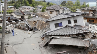


China 2008


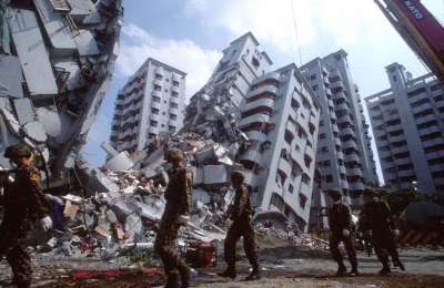
 A force-8 earthquake struck Sichuan Province, China, in 2008. Huge chunks, of rock fell down from the mountains, smashing towns and villages. Tremors were felt up to 1,700 km (1,060 miles) away.


Almost 90,000 people were counted as dead or missing and presumed dead in the final official Chinese government assessment; the officially reported total killed included more than 5,300 children, the bulk of them students attending classes. In addition, nearly 375,000 people were injured by falling debris and building collapses. Hundreds of dams, including two major ones, were found to have sustained damage.


Italy 2009


In 2009, an earthquake measuring 6.3 on a seismograph struck L’Aquila in central Italy. Many buildings collapsed and around 300 people died. Thousands of smaller earthquakes, called aftershocks, followed.


By September 2009 vigorous assistance efforts had succeeded in moving some of the dispossessed into new homes, though thousands remained housed in temporary facilities. The town’s historic centre remained off-limits more than a year after the quake as restoration efforts proceeded slowly, and officials involved in the reconstruction effort were later investigated for wrongdoing in the awarding of public contracts.


Chile 2010


The 2010 Chile earthquake occurred off the coast of central Chile on Saturday, 27 February at 03:34 local time (06:34 UTC), having a magnitude of 8.8 on the moment magnitude scale, with intense shaking lasting for about three minutes. 


 According to official sources, 525 people lost their lives, 25 people went missing and about 9% of the population in the affected regions lost their homes.


Pacific coast of T?hoku 2011


The 2011 earthquake off the Pacific coast of T?hoku  was a magnitude 9.0–9.1 (Mw) undersea megathrust earthquake off the coast of Japan that occurred at 14:46 JST (05:46 UTC) on Friday 11 March 2011, with the epicentre approximately 70 kilometres (43 mi) east of the Oshika Peninsula of T?hoku and the hypocenter at an underwater depth of approximately 29 km (18 mi). 


 It was the most powerful earthquake ever recorded in Japan, and the fourth most powerful earthquake in the world since modern record-keeping began in 1900.


Indian Ocean 2012


The 2012 Indian Ocean earthquakes were magnitude 8.6 and 8.2 Mw? undersea earthquakes that struck near the Indonesian province of Aceh on 11 April at 15:38 local time.


Four people in their 60s and 70s in Banda Aceh, and a 39-year-old man in Lhokseumawe died from heart attacks or shock. Injuries were reported in Aceh Singkil, including a child who was critically injured by a falling tree. The quake prompted people in Indonesia, Thailand and India to leave their homes and offices in fear of tsunamis. 


Okhotsk Sea 2013


The 2013 Okhotsk Sea earthquake occurred with a moment magnitude of 8.3 at 15:44:49 local time (05:44:49 UTC) on 24 May. It had an epicenter in the Sea of Okhotsk and affected primarily (but not only) Asian Russia, especially the Kamchatka Peninsula where the shaking lasted for five minutes.


Iquique 2014


The 2014 Iquique earthquake struck off the coast of Chile on 1 April, with a moment magnitude of 8.2, at 20:46 local time (23:46 UTC).


Four men died of heart attacks and one woman was reportedly crushed to death when a wall collapsed. A loader was crushed by a falling metal structure and died of the injuries afterwards. Around 80,000 were displaced by the event. Electricity and water services were interrupted in the regions of Arica y Parinacota and Tarapacá.


Illapel 2015


The 2015 Illapel earthquake occurred 46 km (29 mi) offshore from Illapel (Coquimbo region, Chile) on September 16 at 19:54:33 Chile Standard Time (22:54:33 UTC), with a moment magnitude of 8.3. 


 Illapel, an inland city of some 30,000 residents, was reported immediately to be without electricity or drinking water. Two days after the quake, about 90,000 people were still without electricity. On September 21, officials were reporting over 9,000 people had been left homeless by the quake.


Ecuador 2016


At 18:58 ECT on April 16, a 7.8 Mw earthquake struck the coast of Ecuador approximately 27 km (17 mi) south-southeast of Muisne, in the province of Esmeraldas, at a depth of 20.6 km (12.8 mi). At least 676 people were killed and more than 16,600 others were injured in the earthquake. It was the worst natural disaster to hit Ecuador since the 1949 Ambato earthquake.


Chiapas 2017


The 2017 Chiapas earthquake struck at 23:49 CDT on 7 September (local time; 04:49 on the 8th UTC) in the Gulf of Tehuantepec off the southern coast of Mexico, near state of Chiapas, approximately 87 kilometres (54 mi) southwest of Pijijiapan (alternately, 101 kilometres (63 mi) south-southwest of Tres Picos), with a Mercalli intensity of IX (Violent).


 Within Chiapas, an estimated 1.5 million people were affected by the earthquake, with 41,000 homes damaged. Jose Calzada, Minister of Agriculture, reported that at least 98 people had died in the earthquake, including 78 in Oaxaca, 16 in Chiapas and 4 in Tabasco.


Fiji 2018


A powerful 8.2 magnitude earthquake occurred in the Pacific Ocean near the islands of Fiji and Tonga on Sunday morning local time, according to the United States Geological Survey (USGS). 


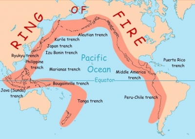
The epicentre of the quake was located 281 km northeast of the Ndoi Island in Fiji at a depth of 560 kilometres. Fiji is located in the Ring of Fire, an area in the basin of the Pacific Ocean, which is vulnerable to frequent earthquakes and volcanic eruptions.


Picture Credit : Google


What are Mild tremors?


Earthquakes that a seismograph records as having a force of 2.5-4 are felt as mild tremors. They cause little or no damage, although trees may sway and windows rattle.


Earthquakes are the vibrations caused by rocks breaking under stress against an underground surface called a fault plane while a tremor is an involuntary movement of earth surface caused by stress in the underground rocks. They are both signs of seismic movement within the earth.


The rumblings being investigated belong to the tectonic tremor, a less hazardous form of seismic activity that occurs far deeper into the earth's core than the devastating earthquakes that occur much closer to the earth's surface.


One major difference between tectonic tremor and earthquakes is that tectonic tremor causes relatively weak ground shaking and is not cause for immediate concern.


Picture Credit : Google


What is Seismograph?


This machine is used to measure the force of the vibrations caused by an earthquake. It records how powerful these vibrations are on a numbered scale.


 They are held in a very solid position, either on the bedrock or on a concrete base. The seismometer itself consists of a frame and a mass that can move relative to it. When the ground shakes, the frame vibrates also, but the mass tends not to move, due to inertia. The difference in movement between the frame and the mass is amplified and recorded electronically.


A network of seismometers is used to calculate the magnitude and source of an earthquake in three dimensions


Seismographs are used to determine:


  • Magnitude: the size of the earthquake

  • Depth: how deep the earthquake was

  • Location: where the earthquake occurred


Picture Credit : Google


What causes an earthquake?


The plates in Earth’s crust constantly side past each other, but can get stuck. Pressures then builds up until the plates finally move, sending out shock waves. The focus of an earthquake is the point inside the ground where pressure builds up. The epicenter is the point on the surface above the focus.


The point at which this slippage occurs is called the FOCUS, whilst the point on the ground surface above the earthquake FOCUS is called the EPICENTRE. Seismic shock waves will emanate radially outwards from these points and their energy will reduce with distance. This is typical of destructive margins (which account for 90% of the World's earthquakes) where the Oceanic plate grinds under a Continental plate (as on the East coast of Japan -see Kobe case study). They also occur at conservative margins, such as the San Andreas Fault line, where the North American plate and Pacific plate are grinding past one another.


Picture Credit : Google


What is Earthquake crack?


An earthquake can cause large cracks to open up in the Earth’s surface. Many are small, no more than a few metres deep or wide, but others are massive, and whole buildings can fall into them.


When an earthquake strikes, it will create fissures into the depths of the earth in random locations, usually with a lot of people. In reality, the ground often just shakes, shifts and quakes — the physical damage is usually to structures on the ground, not the ground itself. If fissures do open up, it is usually due to a landslide triggered by the quake, which means they're restricted to hillsides, mountains, and cliffs. If you see roads with cracks and fissures and dislodged pieces, it is because the wet, sandy ground underneath has liquefied, causing the road to sink unevenly and crack. And yes, that can happen to buildings too.


Picture Credit : Google


What is Earthquake?


When the rocky tectonic plates that form Earth’s crust move suddenly, large waves of energy spread out, causing the ground to shake. This is an earthquake. Some earthquakes are fairly gentle and may even go unnoticed, but others can bring terrible destruction.


Sometimes an earthquake has foreshocks. These are smaller earthquakes that happen in the same place as the larger earthquake that follows. Scientists can’t tell that an earthquake is a foreshock until the larger earthquake happens. The largest, main earthquake is called the mainshock. Mainshocks always have aftershocks that follow. These are smaller earthquakes that occur afterwards in the same place as the mainshock. Depending on the size of the mainshock, aftershocks can continue for weeks, months, and even years after the mainshock!


Picture Credit : Google


What is inside the volcano?


The magma chamber: This is the area with massive collection of magma below the earth’s crust from which magma flows out.


Crater: After an eruption, the tip or top of the volcano tends to get blown off, leaving a small depression at the top of it.


Main vent: This is the main exit point (opening or outlet) in a weak zone where molten magma is released to the surface.


Secondary vents: These are other smaller vents or opening through which ash and gases and lava escape.


Ashes, clouds and cinders: As the eruption continues, ashes and gases are discharged into the air, which is carried further by wind action.


Layers of ash and lava: The walls of a volcano are usually made up of solidified layers of lava and dust.


Picture Credit : Google


What is Volcanoes? What are the types of Volcanoes?


Volcanoes form when magma a mixture of hot gas, ash, and melted rock-erupts from a crack in the Earth’s surface. The melted rock, called lava, flows out and hardens. As layers of lava build up, the volcano gets bigger. A volcano can be active, dormant, or extinct. Volcanoes can and have existed on other worlds as well: although volcanoes on the moon and Mars have long been dormant, volcanoes are still very active on Jupiter's moon Io. Researchers are currently striving to find ways to predict when volcanic eruptions might happen on Earth by analyzing clues such as crystals and gases linked with volcanoes.


Stratovolcano


Stratovolcanoes are tall and cone-shaped, with steep sides. They are made up of lots of layers of lava and ash that have cooled and hardened. Their eruptions can be very powerful and dangerous.


Stratovolcanoes are also called composite volcanoes because they are built of layers of alternating lava flow, ash and blocks of unmelted stone, according to the U.S. Geological Survey. They are larger than cinder cones, rising up to 8,000 feet (2,438 meters). Stratovolcanoes result from a conduit system of vents leading from a magma reservoir beneath the surface. When dormant, they typically have steep concave sides that sweep together at the top around a relatively small crater.


Shield   


Shield volcanoes have gently sloping side and are formed from thin, runny lava. Their eruptions are less explosive and much less dangerous than other volcanoes. These gentle eruptions can continue for years. Eruptions of these volcanoes are not generally explosive, but are more like liquid overflowing around the edges of a container. The world's largest volcano, Mauna Loa in Hawaii, is a shield volcano, according to the U.S. Geological Survey. Mauna Loa is about 55,770 feet (17,000 meters) from its base beneath the ocean to the summit, which is 13,681 feet (4,170 meters) above sea level. It is also one of the Earth's most active volcanoes and is carefully monitored. The most recent eruption was in 1984.


Cinder Cone


Cinder cone volcanoes are the smallest and most common type of volcano. They are cone-shaped with steep sides. Their eruptions are usually not too violent. They may occur as single volcanoes or as secondary volcanoes known as "parasitic cones" on the sides of stratovolcanoes or shield volcanoes. Airborne fragments of lava, called tephra, are ejected from a single vent. The lava cools rapidly and fall as cinders that build up around the vent, forming a crater at the summit, according to the U.S. Geological Survey.


Caldera


Calderas are large, circular hollows, almost like a bowl. They form when a massive eruption forces most of the magma out of the chamber under the volcano, causing it to collapse. Craters are usually more circular than calderas. (Calderas may have parts of their sides missing because land collapses unevenly.) Craters are also usually much smaller than calderas, only extending to a maximum of one kilometer (less than a mile) in diameter. 


Picture Credit : Google


What are Mountains? What are the types of Mountains?


Mountains are formed when the Earth’s tectonic plates move and collide with one another. As the plates continue to move, magma and land may be pushed up, forming mountains.


One other way mountains form is as the result of volcanic activity below Earth's surface. Sometimes molten rock called magma gets pushed up toward the surface. When that happens, it cools and forms hard rock. Eventually, the softer rock above it erodes to reveal a dome-shaped mountain below. If the magma actually breaks through to the surface, you get a volcano!


Mountains can also form by way of erosion. In an area with a high plateau, rivers and streams can carve away stone in the form of deep channels. Over millions of years, what is left is a mountain between deep river valleys!


Fault-block mountains: Cracks in the Earth’s crust can create massive blocks of rock that then move apart. As they move, one block may slide under another, pushing it up. This leaves large blocks of rock sticking up, high above the Earth’s surface. These are fault-block mountains.


Examples of fault-block mountains include:


  • the Sierra Nevada mountains in North America

  • the Harz Mountains in Germany


Dome mountains: When large amounts of the magma under the Earth’s crust bubble up towards the surface, layers of rock above the magma are pushed up to form dome mountains. The inside of these mountains is filled with magma that has cooled and hardened. As the dome is higher than its surroundings, erosion by wind and rain occurs from the top. This

results in a circular mountain range. Domes that have been worn away in places form many separate peaks called Dome Mountains.


Fold mountains: These are the most common type of mountain. They form when two or more tectonic plates are pushed together, causing layers of rock on the seafloor to crumple and fold. Over millions of years, these folded layers are slowly pushed up higher to form mountains.


Examples of Fold Mountains include:


  • Himalayan Mountains in Asia

  • the Alps in Europe

  • the Andes in South America

  • the Rockies in North America

  • the Urals in Russia


Volcanic mountains: A volcanic eruption occurs when magma bubbles up and eventually erupts through a crack in the Earth’s crust. This causes molten rock, known as lava, to flow over the land, before it cools and hardens. Further eruptions create more layers of hardened lava, which build up to form a mountain.


Examples of volcanic mountains include:


  • Mount St. Helens in North America

  • Mount Pinatubo in the Philippines

  • Mount Kea and Mount Loa in Hawaii


Picture Credit : Google


What is the Ring of Fire?


This area in the Pacific Ocean is one of the most unstable parts of the Earth’s crust. Here, the tectonic plates move around a lot, causing some of the world’s worst earthquakes. It is also where there are many active volcanoes.


The Ring of Fire is a string of volcanoes and sites of seismic activity, or earthquakes, around the edges of the Pacific Ocean. Roughly 90% of all earthquakes occur along the Ring of Fire, and the ring is dotted with 75% of all active volcanoes on Earth. 


The Ring of Fire isn’t quite a circular ring. It is shaped more like a 40,000-kilometer (25,000-mile) horseshoe. A string of 452 volcanoes stretches from the southern tip of South America, up along the coast of North America, across the Bering Strait, down through Japan, and into New Zealand. Several active and dormant volcanoes in Antarctica, however, “close” the ring.


Picture Credit : Google


What are the Plate boundaries? What are the types of Plate Boundaries?


These are where the edges of tectonic plates meet. There are three main types – convergent, divergent, and transform boundaries. They differ in low the plates involved meet.


Convergent boundary:


Where two plates are colliding.


Subduction zones occur when one or both of the tectonic plates are composed of oceanic crust. The denser plate is subducted underneath the less dense plate. The plate being forced under is eventually melted and destroyed.


i. Where oceanic crust meets ocean crust

Island arcs and oceanic trenches occur when both of the plates are made of oceanic crust. Zones of active seafloor spreading can also occur behind the island arc, known as back-arc basins. These are often associated with submarine volcanoes.


ii. Where oceanic crust meets continental crust

The denser oceanic plate is subducted, often forming a mountain range on the continent. The Andes is an example of this type of collision.


iii. Where continental crust meets continental crust

Both continental crusts are too light to subduct so a continent-continent collision occurs, creating especially large mountain ranges. The most spectacular example of this is the Himalayas.


Transform boundary:


Where plates slide passed each other.


The relative motion of the plates is horizontal. They can occur underwater or on land, and crust is neither destroyed nor created.


Because of friction, the plates cannot simply glide past each other. Rather, stress builds up in both plates and when it exceeds the threshold of the rocks, the energy is released – causing earthquakes.


Divergent boundary:


Where two plates are moving apart.


The space created can also fill with new crustal material sourced from molten magma that forms below. Divergent boundaries can form within continents but will eventually open up and become ocean basins.


i. On land

Divergent boundaries within continents initially produce rifts, which produce rift valleys.


ii. Under the sea

The most active divergent plate boundaries are between oceanic plates and are often called mid-oceanic ridges.


Picture Credit : Google


What is the structure of the Earth?


Planet Earth is made up of a number of different layers. Some of these are solid, while others are liquid or a mixture of both. Knowing about Earth’s structure will help you understand what is happening on the surface- where you live.


Water


 Seas and oceans cover about 71 per sent of Earth’s surface.


Land


Just 29 percent of Earth surface is land, which is split up into continents.


Inside and outside


Ocean and land cover Earth’s surface, but inside are many complex layers.


Crust


The crust is the thinnest layer of the Earth and is the layer we live on.  It is made up of a variety of rocks and can reach up to 70 km thick in places.  The crust itself is divided into large chunks called tectonic plates.  There are around 7 large and 12 small plates, which ‘float’ on top of the mantle beneath them.  The plates themselves are made up of 2 different types of crust, continental crust under the land and oceanic crust under the sea.  Continental crust is thick (25-70 km) and light because it is made of rocks with a low density.  Oceanic crust is thin (6-11 km) and heavy because it is made of rocks (mostly volcanic rocks) that have a high density.  The oceanic crust covers 2/3 of the Earth’s surface.


Continental crust


Mixtures of different rocks are found in this layer, which forms all of the land found on Earth. The continental crust is older than the oceanic crust. As with oceanic crust, continental crust is created by plate tectonics. At convergent plate boundaries, where tectonic plate’s crash into each other, continental crust is thrust up in the process of orogeny, or mountain-building. For this reason, the thickest parts of continental crust are at the world’s tallest mountain ranges. Like icebergs, the tall peaks of the Himalayas and the Andes are only part of the region’s continental crust—the crust extends unevenly below the Earth as well as soaring into the atmosphere.


Oceanic crust


This rocky layer under the Earth’s seas and oceans is constantly changing, as tectonic plates move around and liquid rock, or magma, rises up from the asthenosphere, then cools and hardens.


Oceanic crust is about 6 km (4 miles) thick. It is composed of several layers, not including the overlying sediment. The topmost layer, about 500 metres (1,650 feet) thick, includes lavas made of basalt (that is, rock material consisting largely of plagioclase [feldspar] and pyroxene). Oceanic crust differs from continental crust in several ways: it is thinner, denser, younger, and of different chemical composition. Like continental crust, however, oceanic crust is destroyed in subduction zones.


Mantle


The mantle is the thickest layer of the Earth at 2,900 km thick.  It makes up nearly 80% of the volume of the Earth.  The mantle itself is divided into 2 layers, the upper and lower mantles and the heat within these layers drives convection currents.


Lower mantle


The layer of solid rock reaches temperatures of up to 3,000°C(5,432°F). This is hot enough to melt the rock, but pressure pushing down prevents this.


The lower mantle is the lower liquid portion of the mantle ranging from 400 miles below the surface to about 1,800 miles below the surface. The lower mantle is incredibly large and takes up most of the volume of the earth. Being so deep inside the earth, the temperature and pressure of the lower mantle are extremely high. Temperatures can soar to over 7,000 degrees Fahrenheit at the bottom edge of the lower mantle, near the core. Pressure in the lower mantle is a maximum of 1.3 million times that of the surface, creating minerals we normally would not see in the crust.


Upper mantle


The upper mantle begins just beneath the crust and ends at the lower mantle. The thickness of the upper mantle is between 200 and 250 miles. The entire mantle is about 1800 miles thick, which means the lower mantle makes up the bulk of this part of the Earth. The temperature of the mantle near the crust ranges from 900 to 1600 degrees Fahrenheit. It gets hotter at greater depths. The lower mantle near the core is as hot as 7000 degrees Fahrenheit.


This layer is made of both solid and liquid rock. It is constantly moving, which is why the tectonic plates that form Earth’s crust also move around on top of it.


Outer core


The outer core, about 2,200 kilometers (1,367 miles) thick, is mostly composed of liquid iron and nickel. The NiFe alloy of the outer core is very hot, between 4,500° and 5,500° Celsius (8,132° and 9,932° Fahrenheit). 


 The liquid metal of the outer core has very low viscosity, meaning it is easily deformed and malleable. It is the site of violent convection. The churning metal of the outer core creates and sustains Earth’s magnetic field.


 The hottest part of the core is actually the Bullen discontinuity, where temperatures reach 6,000° Celsius (10,800° Fahrenheit)—as hot as the surface of the sun.


Inner core


At the centre of the Earth is a huge ball of solid metal- mostly iron- called the inner core. It can reach temperatures of up to 5,500°C (10,000°F), as hot as the Sun’s surface.


The inner core was discovered by Inge Lehmann in 1929, using seismology. Lehmann was studying a large New Zealand earthquake. An earthquake makes vibrations which move through the inside of the Earth. The vibrations Lehmann studied seemed to be moving across something solid in the center of the planet. She called this the inner core. She wrote about it for many years, but it was not proved to exist until 1970.


The inner core is more than 5,000 kilometers below the earth's surface. The pressure in Earth's inner core is about 3,500,000 atmospheres. Iron can only be solid at such high temperatures because its melting temperature increases dramatically at such pressures.


Picture Credit : Google


What is the story of the Earth?


It is thought that Earth, and the other planets, formed as gravity forced material in clouds of gas and dust together, creating clumps of rock. These gradually grew bigger to form planets. This cloud of gas and dust was disturbed, perhaps by the explosion of a nearby star (a supernova), and the cloud of gas and dust started to collapse as gravity pulled everything together, forming a solar nebula—a huge spinning disk. As it spun, the disk separated into rings and the furious motion made the particles white-hot.


The center of the disk accreted to become the Sun, and the particles in the outer rings turned into large fiery balls of gas and molten-liquid that cooled and condensed to take on solid form. About 4.5 billion years ago, they began to turn into the planets that we know today as Earth, Mars, Venus, Mercury, and the outer planets.


The first era in which the Earth existed is what is known as the Hadean Eon. This name comes from the Greek word "Hades" (underworld), which refers to the condition of the planet at the time. This consisted of the Earth's surface being under a continuous bombardment by meteorites and intense volcanism, which is believed to have been severe due to the large heat flow and geothermal gradient dated to this era.Over time, the conditions on Earth evolved to support life.


Picture Credit : Google


What are Planes?


Planes usually fly in the troposphere, but may go up to the edge of the stratosphere. Little moisture enters the stratosphere, so clouds are rare. Even though the stratosphere has complex wind systems, violent storms don't occur there. Because the air temperature in the stratosphere slowly increases with altitude, it does not cause convection and has a stabilizing effect on atmospheric conditions in the region. Stability generally limits vertical extensions of cloud and leads to the lateral spreading of high cumulonimbus cloud with characteristic anvil heads. This means that weather (in the form of clouds) is almost entirely confined to the troposphere below. That's why airline pilots prefer to fly in the stratosphere.


Picture Credit : Google


What is Ozone layer?


This thin layer, running across the stratosphere, contains a large amount of ozone, a gas that absorbs ultraviolet (UV) rays from the Sun. UV rays cause sunburn, and can cause skin cancer.


Approximately 90 percent of the atmosphere’s ozone occurs in the stratosphere, the region extending from 10–18 km (6–11 miles) to approximately 50 km (about 30 miles) above Earth’s surface. In the stratosphere the temperature of the atmosphere rises with increasing height, a phenomenon created by the absorption of solar radiation by the ozone layer. The ozone layer effectively blocks almost all solar radiation of wavelengths less than 290 nanometres from reaching Earth’s surface, including certain types of ultraviolet (UV) and other forms of radiation that could injure or kill most living things.


Picture Credit : Google