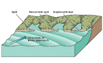
WHAT IS A BLOWHOLE?

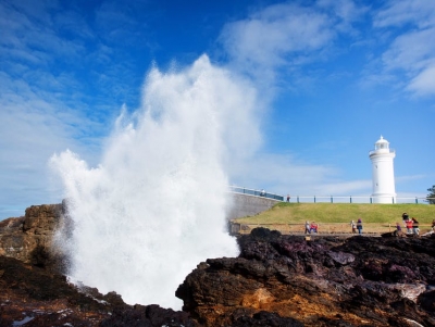
Sometimes, the rocks along a coastline have a crevice or hole just above the low-tide mark. When the high tide rushes in, the crevice fills up with water, which tries to escape through this narrow hole. The build-up of pressure sprays out the water as an upward plume with a loud sound. This is a blowhole. Over time, a blowhole can create caves or even a pool of water near the coast.

When sea caves grow towards the land and upwards creating a vertical shaft that exposed on the surface, it results in a blowhole. Water often gushes out at the top part of the landform when waves move to the sea cave with significant force. The activities of the blowhole depend on the sea conditions as well as its geometry and that of the sea cave. A blowhole is characterized by an opening on the ground and a connection to an opening which interacts with the sea, mostly a cave.

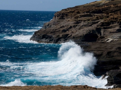
Sea Caves are a common feature along the coasts and are formed through mechanical erosion of cliffs. Parts of weakness in the cliffs are weathered out by wave action thereby forming large cavities known as sea caves. These caves are regularly exposed to waves. Hydraulic pressure, built up by a succession of waves, eventually carves out a hole at the top of the cave to create an opening for water pressure to be expelled as a jet of spray. A blowhole can also be formed when lava flows make openings in the ground which extend towards the sea. The landform manifests as a crack or fissure once formed.

Credit: World Atlas

Picture Credit : Google 

WHAT IS A BAYMOUTH BAR?

When the movement of waves deposits gravel and sand in a manner that prevents access to a bay, it builds up a baymouth bar. The existence of the bar creates a shallow lake known as a lagoon that is separated from the sea by a beach.

A baymouth bar is a depositional feature as a result of longshore drift. It is a spit that completely closes access to a bay, thus sealing it off from the main body of water. These bars usually consist of accumulated gravel and sand carried by the current of longshore drift and deposited at a less turbulent part of the current. Thus, they most commonly occur across artificial bay and river entrances due to the loss of kinetic energy in the current after wave refraction.

In most cases, a Sand Bypass System is built to prevent these bars forming across the entrance of man-made seaway's, eliminating the danger posed to commercial and recreational boat owners passing through.

credit: en-academic.com

Picture Credit : Google 

WHICH IS THE LARGEST BLOWHOLE?

The Kiama Blowhole is a blowhole in the town of Kiama, New South Wales, Australia. The name ‘Kiama’ has long been translated as “where the sea makes a noise”. It is one of the town's major tourist attractions. Under certain sea conditions, the blowhole can spray 50 litres of water up to 25 metres (82 ft) in the air, in quantities that thoroughly drench any bystanders. There is a second, less famous blowhole in Kiama, commonly referred to as the "Little Blowhole" by locals. It is much smaller than the other (called the "Big Blowhole"), but due to its narrow shape, it is more reliable than the Big Blowhole, and in the right conditions can be equally spectacular.

The blowhole attracts 900,000 tourists a year. Kiama Blowhole is just a few metres beyond the coastline. The "little blowhole" is located at the Little Blowhole Reserve, Tingira Crescent, Kiama, 2km south of the main blowhole.

The blowhole was formed from basalt lava flows approximately 260 million years ago and was first discovered by local Aboriginals who named it 'Khanterinte'. The blowhole was first written about by George Bass on 6 December 1797. Bass had captained a crew of six and set out on an open whaleboat to explore the south coast of Australia. He noticed the blowhole after anchoring his boat in a sheltered bay.

Credit: Wikipedia

Picture Credit : Google 

WHAT IS A TOMBOLO?

Tombolo, one or more sandbars or spits that connect an island to the mainland. A single tombolo may connect a tied island to the mainland, as at Marblehead, Mass. A double tombolo encloses a lagoon that eventually fills with sediment; fine examples of these occur off the coast of Italy. The shallower waters that occur between an island and the mainland are the loci of such features because sandbars form there.

Adam’s Bridge, which connected Sri Lanka (Ceylon) with India across the 33-mile (53-kilometre) wide Palk Strait, was formerly the world’s largest tombolo. It was destroyed several thousand years ago by a slight change in mean sea level, and only a chain of sandbanks that seriously hinder navigation exists there today.

Credit: Britannica

Picture credit: Wikipedia


DOES THE SEA WEAR AWAY LAND?

Sea waves constantly crash into coasts, crushing rocks and pebbles. Rising waves hurl small rocks onto seaside cliffs, eroding them or tearing away at their base until they collapse. Waves and water currents carry sand and gravel that can alter coastlines. The sea and its waves can certainly wear away the land.

Coastal erosion is the wearing away of the land by the sea often involves destructive waves wearing away the coast (though constructive waves also contribute to coastal erosion).

There are four main processes of coastal erosion. These are corrasion, abrasion, hydraulic action and attrition.

Corrasion is when destructive waves pick up beach material (e.g. pebbles) and hurl them at the base of a cliff. Over time this can loosen cliff material forming a wave-cut notch.

Abrasion occurs as breaking waves, concentrated between the high and low watermarks, which contain sand and larger fragments wear away the base of a cliff or headland. It is commonly known as the sandpaper effect. This process is particularly common in high-energy storm conditions.

Waves hitting the base of a cliff causes air to be compressed in cracks, joints and folds in bedding planes causing repeated changes in air pressure. As air rushes out of the cliff when the wave retreats it leads to an explosive effect as pressure is released. This process is supported further by the weakening effect of weathering. The material breaks off cliffs, sometimes in huge chunks. This process is known as hydraulic action.

Attrition is when waves cause rocks and pebbles to bump into each other and break up.

Credit: internet geography

Picture Credit : Google

HOW DID THE AMAZON RIVER GET ITS NAME?

The Spanish soldiers who explored the region for the first time in 1541 battled native female warriors who fought bravely. The name the invaders gave to the river came from the Persian hamazan, meaning ‘those who fight together’ - also used in Greek mythology for outstanding women warriors.

Before the conquest of South America, the Rio Amazonas had no general name; instead, indigenous peoples had names for the sections of the river they occupied, such as Paranaguazu, Guyerma, Solimões, and others.

In the year 1500, Vicente Yañez Pinzon, in command of a Spanish expedition, became the first European to explore the river, exploring its mouth when he discovered that the ocean off the shore was freshwater. Pinzon called the river the Rio Santa Maria de la Mar Dulce, which soon became abbreviated to Mar Dulce, and for some years, after 1502, it was known as the Rio Grande.

Pinzon's companions called the river El Río Marañón. The word Marañón is thought by some to be of indigenous origin. This idea was first stated in a letter from Peter Martyr to Lope Hurtado de Mendoza in 1513. However, the word may also be derived from the Spanish word maraña; meaning a tangle, a snarl, which well represents the bewildering difficulties that the earlier explorers met in navigating not only the entrance to the Amazon, but the whole island-bordered, river-cut, and indented coast of what is now the Brazilian state of Maranhão.

The name Amazon arises from a battle that Francisco de Orellana had with a tribe of Tapuyas where the women of the tribe fought alongside the men, as was the custom among the entire tribe. Orellana derived the name Amazonas from the ancient Amazons of Asia and Africa described by Herodotus and Diodorus.

Credit: New World Encyclopedia

Picture Credit : Google

HOW OLD IS THE NILE RIVER?

The Nile River flowing through Egypt could be six times as old as previously thought, according to a study which estimated it to have originated at least 30 million years ago. The study, published in the journal Nature Geoscience, assessed the links between the geographical and physical features — or topography — of the Nile River to the flow of molten rocks in the Earth’s mantle.

The researchers, including those from the University of Texas (UT) at Austin in the US, connected the tilted nature of the Nile’s topography to a conveyor belt of mantle rock pushing up against the Ethiopian Highlands in the south, and pulling the surface down in the north. This gentle gradient, they said, keeps the Nile on a consistent northward course from its beginning to the end. The study said the Nile would have turned west long ago — probably changing the course of history along with it — if it weren’t for the mantle movement keeping the river on course.

Picture Credit : Google