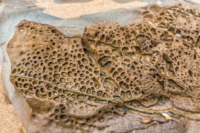
WHAT IS HONEYCOMB WEATHERING?

When salt water that collects on the rough surface of rocks, or seeps into cracks, evaporates, it leaves behind salt crystals. Over time, these crystals alter the rock, forming hundreds and thousands of tightly joined pits called honeycombs that are a classic example of both physical and chemical weathering.

Honeycomb weathering occurs throughout the world, but the origin remains a matter of controversy. Wind erosion, exfoliation, frost shattering, and salt weathering have been proposed as explanations, although few attempts have been made to substantiate these hypotheses with chemical or mineralogical studies.

Chemical analyses and field observations indicate that honeycomb weathering in coastal exposures of arkosic sandstone near Bellingham, Washington, results from evaporation of salt water deposited by wave splash. Microscopic examination of weathered surfaces show that erosion results from disaggregation of mineral grains rather than from chemical decomposition. Thin walls separating adjacent cavities seem to be due to protective effects of organic coatings produced by microscopic algae inhabiting the rock surface. Cavity walls are not reinforced by precipitation of elements released by weathering, as has often been suggested at other locations. Honeycomb weathering develops rapidly and can be observed on surfaces that were planar less than a century ago.

Credit: Geo Science World

Picture Credit : Google 

What is the difference between weathering and Erosion?

Weathering is the result of rocks wearing down because of the actions of the forces of   nature. It is a natural process. During weathering, the rocks in their changed form remain in the same place - there is no movement of material. Erosion, on the other hand, happens when the broken-down rocks are carried away by water, ice, wind or gravity, and the remains are deposited far away from the place where the change initially happened.

Weathering and erosion are forms by which rocks are separated and moved from their unique location. They vary depending on whether a rock's location is changed: weathering debases a rock without moving it, while erosion diverts rocks and soil from their unique locations. Weathering frequently prompts erosion by making rocks separate into little pieces, which erosive forces would then be able to move away.

Primarily, the difference between erosion and weathering is that weathering happens to set up though erosion includes movement to another location. Both are brought about by quite similar factors such as wind, water, ice, temperature, and even natural activity. They can likewise happen together.

                            Erosion

                              Weathering 

Erosion refers to the displacement of the solids through wind, water, and ice.

Weathering refers to the decomposition of the rocks, soil, and minerals through direct contact with the atmosphere.

The eroded materials are displaced in the case of erosion.

The weathered materials are not displaced in the case of weathering.

The several types of erosion include water, wind, thermal, ice, and gravity erosion.

The several types of weathering include physical, chemical, and biological weathering.

Wind, ice, water, and human activities are some of the major causes of erosion.

Weathering is caused because of atmospheric factors like air pressure.

Credit: Vedantu

Picture Credit : Google 

HOW QUICKLY DOES LAND GET WORN AWAY?

Erosion is the geological process in which earthen materials are worn away and transported by natural forces such as wind or water. A similar process, weathering, breaks down or dissolves rock, but does not involve movement.

Erosion is the opposite of deposition, the geological process in which earthen materials are deposited, or built up, on a landform.

Most erosion is performed by liquid water, wind, or ice (usually in the form of a glacier). If the wind is dusty, or water or glacial ice is muddy, erosion is taking place. The brown color indicates that bits of rock and soil are suspended in the fluid (air or water) and being transported from one place to another. This transported material is called sediment.

Credit: National Geographic Society

Picture Credit : Google 

WHAT IS GROUNDWATER?

Rainwater seeps below the surface of the Earth and soaks the soil. When there is more water than the soil can absorb, it can seep even further down until it is surrounded by rocks, creating a kind of storage area, known as an aquifer. The water here is groundwater, and the upper level of water is called the water table.

Water that has travelled down from the soil surface and collected in the spaces between sediments and the cracks within rock is called groundwater. Groundwater fills in all the empty spaces underground, in what is called the saturated zone, until it reaches an impenetrable layer of rock. Groundwater is contained and flows through bodies of rock and sediment called aquifers. The amount of time that groundwater remains in aquifers is called its residence time, which can vary widely, from a few days or weeks to 10 thousand years or more. 

The top of the saturated zone is called the water table, and sitting above the water table is the unsaturated zone, where the spaces in between rocks and sediments are filled with both water and air. Water found in this zone is called soil moisture, and is distinct from groundwater.

Existing groundwater can be discharged through springs, lakes, rivers, streams, or manmade wells. It is recharged by precipitation, snowmelt, or water seepage from other sources, including irrigation and leaks from water supply systems.

Credit: National Geographic Society

Picture Credit : Google 

WHAT IS SCREE?

Loose rocks of roughly the same size littered on steep mountain slopes.

Scree is a collection of broken rock fragments at the base of a cliff or other steep rocky mass that has accumulated through periodic rockfall. Landforms associated with these materials are often called talus deposits. Talus deposits typically have a concave upwards form, where the maximum inclination corresponds to the angle of repose of the mean debris particle size. The exact definition of scree in the primary literature is somewhat relaxed, and it often overlaps with both talus and colluvium.

The formation of scree and talus deposits is the result of physical and chemical weathering acting on a rock face, and erosive processes transporting the material downslope.

There are five main stages of scree slope evolution: (1) accumulation, (2) consolidation, (3) weathering, (4) encroaching vegetation, and finally, (5) slope degradation.

Credit: Wikipedia

Picture Credit : Google 

HOW DO WE MEASURE CONTINENTAL DRIFT?

Satellite tracking stations were initially used to measure continental drift. At present, an accurate measurement can be done through GPS trackers. Radio telescopes also give an accurate reading.

Geologists in the early 1900's (and earlier) observed related fossil assemblages and rock groups on the margins of different continents separated by large oceans. Continental drift theory proposed that the continents were once contiguous. Measuring the distance across the ocean basins provided a distance of drift, but not a rate.

Scientists in the 1960's used magnetometers to survey the ocean floor (the magnetometers were retired sub-hunters from WWII). They observed parallel bands of seafloor with the same magnetic orientation and intensity. They noticed that the bands were symmetric on either side of large ridges in the oceans. Plate tectonics proposes that the continents are going along for the ride as oceanic crust grows and spreads from ridges. The scientists used radiometric dating to calibrate the magnetic bands with a magnetic reversal time scale.

We now have the distance that the continents are from each other, and ages for the bands of oceanic crust between them, so we can calculate a rate. For example, the oldest crust in the Atlantic is about 180 million years old, and it is found off the eastern margin of North America and the Western margin of Africa (~6000 km).

6000km/180 million years = ~3.3 cm/year (Averaged over 180 million years, this is a very rough calculation).

This is how fast Africa and North America have cruised apart on average over the last 180 million years.

Credit: UCSB Science Line

Picture Credit : Google

FROM WHERE IN THE SUPERCONTINENT DID ANTARCTICA BREAK AWAY?

Gondwana was an ancient supercontinent that broke up about 180 million years ago. The continent eventually split into landmasses we recognize today: Africa, South America, Australia, Antarctica, the Indian subcontinent and the Arabian Peninsula.

According to plate tectonic evidence, Gondwana was assembled by continental collisions in the Late Precambrian (about 1 billion to 542 million years ago). Gondwana then collided with North America, Europe, and Siberia to form the supercontinent of Pangea. The breakup of Gondwana occurred in stages. Some 180 million years ago, in the Jurassic Period, the western half of Gondwana (Africa and South America) separated from the eastern half (Madagascar, India, Australia, and Antarctica). The South Atlantic Ocean opened about 140 million years ago as Africa separated from South America. At about the same time, India, which was still attached to Madagascar, separated from Antarctica and Australia, opening the central Indian Ocean. During the Late Cretaceous Period, India broke away from Madagascar, and Australia slowly rifted away from Antarctica. India eventually collided with Eurasia some 50 million years ago, forming the Himalayan Mountains, while the northward-moving Australian plate had just begun its collision along the southern margin of Southeast Asia.

Credit: Britannica

Picture Credit : Google

WHAT IS CONTINENTAL DRIFT?

In the early 20th century, German scientist Alfred Wegener termed the movement over geological time of Earth’s major landmasses- Europe, the Americas, Africa, Australia, Asia and Antarctica- as ‘continental drift’. However, the modern day term is plate tectonics. Wegener suggested that landmasses may have pulled apart or pushed together to create new landforms. For example, he found evidence for this when he discovered fossils in Norway that indicated they originated in a tropical climate.

Continental drift describes one of the earliest ways geologists thought continents moved over time. Today, the theory of continental drift has been replaced by the science of plate tectonics.

The theory of continental drift is most associated with the scientist Alfred Wegener. In the early 20th century, Wegener published a paper explaining his theory that the continental landmasses were “drifting” across the Earth, sometimes plowing through oceans and into each other. He called this movement continental drift. 

Pangaea

Wegener was convinced that all of Earth’s continents were once part of an enormous, single landmass called Pangaea.

Wegener, trained as an astronomer, used biology, botany, and geology describe Pangaea and continental drift. For example, fossils of the ancient reptile mesosaurus are only found in southern Africa and South America. Mesosaurus, a freshwater reptile only one meter (3.3 feet) long, could not have swum the Atlantic Ocean. The presence of mesosaurus suggests a single habitat with many lakes and rivers.

Wegener also studied plant fossils from the frigid Arctic archipelago of Svalbard, Norway. These plants were not the hardy specimens adapted to survive in the Arctic climate. These fossils were of tropical plants, which are adapted to a much warmer, more humid environment. The presence of these fossils suggests Svalbard once had a tropical climate.

Finally, Wegener studied the stratigraphy of different rocks and mountain ranges. The east coast of South America and the west coast of Africa seem to fit together like pieces of a jigsaw puzzle, and Wegener discovered their rock layers “fit” just as clearly. South America and Africa were not the only continents with similar geology. Wegener discovered that the Appalachian Mountains of the eastern United States, for instance, were geologically related to the Caledonian Mountains of Scotland.

Pangaea existed about 240 million years ago. By about 200 million years ago, this supercontinent began breaking up. Over millions of years, Pangaea separated into pieces that moved away from one another. These pieces slowly assumed their positions as the continent we recognize today.

Credit: National Geographic Society

Picture credit: Dreamstime.com

WHAT IS SIGNIFICANT ABOUT THE CENOZOIC ERA?

Life on our planet developed millions of years ago, but if large life-forms are taken into consideration, then intelligent organisms like the Homo sapiens have never dominated any specific era or even a period. The Cenozoic Era can be known as the arrival and dominance of intelligent life-forms like modern human beings, which changed the world scenario permanently.

The term 'Cenozoic' has been derived from the Greek words: kainos meaning 'new' and zoe meaning 'life'. It is the shortest era of the Earth, spanning from about 66 million years ago to the present. After the sudden K-T boundary mass extinction, mammals got a chance to evolve extensively in this era, and hence, it is also called 'The Age of The Mammals'. The climate of our planet stabilized and atmospheric oxygen slowly increases with a simultaneous decrease in carbon dioxide and other toxic gaseous elements.

Earlier, the Cenozoic comprised two periods: Tertiary and Quaternary, the former being divided into Paleogene and Neogene, but now the term Tertiary is slowly phased out. Instead, the era is now divided into three periods: Paleogene, Neogene, and Quaternary, ranging from the oldest to the youngest. They are again subdivided into a number of stages/epochs. Apart from mammals, the Aves class of Chordates, i.e., the birds also evolved a lot, and several of them were larger than the average height of a human.

Credit: science.earthjay.com

Picture Credit : Google

WHY IS THE CAMBRIAN PERIOD IMPORTANT?

The Cambrian period extended from 541 to 485.4 million years ago. It was a time when the Earth was still cold but gradually getting warmer. All pre-Cambrian life was aquatic and soft-bodied. But because Cambrian creatures had hard body parts, many of the earliest known fossils are from this period.

The Cambrian Period marks an important point in the history of life on Earth; it is the time when many kinds of invertebrates and the first vertebrates—fishes—appeared in the fossil record. The Burgess Shale contains the best record of Cambrian animal fossils including soft-bodied forms. This locality reveals the presence of creatures originating from the “Cambrian explosion”—an evolutionary burst of animal origins dating from 545 to 525 million years ago. The “explosion” describes the very rapid proliferation of a truly amazing diversity of living things on Earth. Most of these creatures are now extinct and are known only from their fossils.

During Cambrian time, life was only common in the water. The land was barren and subject to erosion; these geologic conditions led to mudslides, where sediment periodically rolled into the seas and buried marine organisms. At the Burgess Shale locality in the Canadian Rocky Mountains, sediment was deposited in a deep-water basin adjacent to an enormous algal reef with a vertical escarpment several hundred feet high.

Credit: National Park Service

Picture Credit : Google

HOW ARE FOSSILS FORMED?

When a plant or animal is buried quickly, it gets enclosed in sediment before it decomposes. As pressure transforms this sediment into rock, a hollow mould of the organism is formed. Gradually minerals seep into this hollow and harden over time to form a detailed, three-dimensional cast. Soft tissue organisms are preserved as impressions between layers of sediment. Perfectly preserved fossils of insects and other small forms of life have also been found trapped inside hardened tree sap.

The most common way an animal such as a dinosaur fossilises is called petrification. These are the key steps:

1. The animal dies.

2. Soft parts of the animal's body, including skin and muscles, start to rot away. Scavengers may come and eat some of the remains.

3. Before the body disappears completely, it is buried by sediment - usually mud, sand or silt. Often at this point only the bones and teeth remain.

4. Many more layers of sediment build up on top. This puts a lot of weight and pressure onto the layers below, squashing them. Eventually, they turn into sedimentary rock.

5. While this is happening, water seeps into the bones and teeth, turning them to stone as it leave behind minerals.

This process can take thousands or even millions of years.

Credit: Natural History Museum

Picture Credit: Learning Geology

WHY IS THE STUDY OF FOSSILS USEFUL?

Fossils, both plant and animal, are a valuable source of information on how life has evolved on Earth - they are a window into the past. They also provide insight on ecological, climatic and environmental changes that have taken place over the ages.

1. Beginnings of life. Apart from the sheer wonder they see the morphology of giant creatures millions of years ago from studying their fossil remains, fossils teach us about the beginnings and transformations of life itself.

2. Ecosystems. Fossils help us understand the environment where extinct life forms once existed.

3. Human origin. Paleo-anthropologists study the beginnings of human life, from the tools our ancestors used, the food they ate, their physical adjustments, to their social behaviour and migration.

4. Age of the country. All living organisms inhabited the Earth only at certain intervals and are reflected in the fossil record in sequence by each layer of rocky sediment.

5. Our past and future. The study of fossils also leads to discoveries and understandings of processes on Earth that may be of benefit to mankind.

It is wonderful for everyone to find stones that sometimes have figures of animals inside and out. People learn from fossils – Whether fossils are from humans or dinosaurs, they may not learn much about the species and cultures that existed in the past. Fossils give us educated guesses about the evolution of different species and what the climate looked like in the past.

Credit: Teach with Europeana

Picture Credit : Google

WHAT IS AN ARCHIPELAGO?

The word archipelago refers to an island chain. An archipelago is a type of landform that consists of a group of islands, often including similar formations like atolls or islets. The islands that make up an archipelago are clustered or form a chain within a body of water, such as an ocean, gulf, sea, or lake.

The Hawaiian Islands, the Aleutian Islands, the Florida Keys, Bermuda, The Bahamas, the Philippines, the Canary Islands, Indonesia, and islands in the Aegean Sea are all examples of archipelagos.

Archipelagos have been formed by seafloor volcanism, sea level rise or fall, coral reefs, and occasionally by the actions of people.

  • Most archipelagos include a combination of inhabited and uninhabited islands, including ones that can only be accessed by sea.
  • They can be made up of volcanic islands or continental fragments, or be formed via processes like erosion, sedimentary deposits or rising sea levels.
  • Some are large, spreading out over thousands of miles, while others extend over much smaller areas of less than 100 miles

.Credit: yourdictionary.com

Picture Credit : Google 

WHICH IS THE LONGEST BEACH?

Praia do Cassino (Portuguese for Casino Beach) is the longest sea beach in the world and is located in the southernmost of the Brazilian coast, on the South Atlantic Ocean, in the state of Rio Grande do Sul. It is the longest uninterrupted sandy seashore in the world, with various sources measuring it from 212 kilometres (132 mi) to 254 kilometres (158 mi), stretching from the Molhes (breakwaters) at the entrance of the Rio Grande seaport in the north to the mouth of the Chuí Stream, on the border with Uruguay, in the south. Praia do Cassino in Brazil stretches for 241.40 km.

Cassino Beach is known as the oldest spa in Brazil, dating back to 1890. The beach was developed by the Suburban Mangueira Company as a tourist destination. The director of the company, Antonio Condido Sequeira, and the investors of the company acquired the land in the beach area with the help of the state government and built a tourist complex on January 26, 1890. Later this tourist center became very popular and big companies started investing here. At the time, Brazilians of German, English, Portuguese, and Italian descent often came to the beach to enjoy the sea in expensive hotels. The persecution of Italians and Germans during World War II and the ban on roulette in 1948 had a devastating effect on the region’s economy.

The Praia do Casino was recognized as the longest beach in the world by Guinness World Records in 1994.

Around 150,000 tourists visits Praia do Cassino every year. During the summer season, especially from December to January, the number of tourists visiting this place increases. Tourists can be seen participating in various activities including swimming and surfing. This beach is home to the largest number of seals in the world. Many tourists visit these seals by boat.

Credit: Wikipedia

Picture Credit : Google 

HOW IS A ROCK ARCH CREATED?

When a high, rocky outcrop juts out into the water, the crashing of waves over the years erodes the base. If the layer of rock higher up stays intact as the base is worn through, a natural rock arch is carved out.

Most people understand that erosion plays an important role in creating arches and bridges. A natural rock arch is formed by erosion. There are two types of erosive forces that account for most arches and bridges – weather erosion and water erosion.

If a crack forms in the soft layers of a sandstone fin, it allows wind to penetrate into the rock. In the desert, winds are common, and they carry lots of sand – kind of like a natural sandblaster – this can cause the cracks to widen. Acidic rain can accumulate in these cracks, chemically weakening the rock. Then, freezing and thawing frosts can cause fractured sections of rock to break off. With enough time, the constant cycle of wind, ice and rain will form an arch. This is weather erosion, and most arches and bridges throughout the world were formed this way.

Water erosion relies, as the name suggests, almost entirely on running water to create arches and bridges. Streams and rivers may eventually cut through a fin of sandstone (this is how Rainbow Bridge was formed) or acidic rain-water might pool in depressions and create an arch from above (Double Arch in Arches National Park is the perfect example of this).

Credit: NATURAL UNIVERSAL SECRETS

Picture Credit : Google