WORLD ATLAS - SOUTH AMERICA


South America is a continent of extremes. The world’s longest mountain range, the Andes, stretches along the west coast. Between the snow-capped mountains lies a high, cold and windswept plain called the altiplano. Between the Andes and the Pacific Ocean coast is the Atacama Desert, the driest place on earth. Rain may not fall here for hundreds of years at a time.


In the north, most people live near the Caribbean coast or in the mountains. Further inland, the vast rainforests of the Amazon basin dominate. The Amazon River originates in the Andes and winds its way eastwards through Peru and Brazil before reaching the Atlantic Ocean.


To the east of the Amazon rainforest lie the Brazilian Highlands. Further south are wide areas of fertile grasslands, known as pampas, which cover parts of Argentina and Uruguay. In the extreme south of Argentina, grasslands give way to the dry, bleak scrublands of Patagonia. The southern Andes is an region of glaciers and volcanoes, breaking up into bleak, rocky islands at its tip.


Many people in South America are descended from Europeans, especially the Spanish and Portuguese, who began to arrive during the 15th century. Most South American people today still speak these languages. Others are descendents of African slaves brought over by the Europeans. The numbers of native peoples of South America fell dramatically after the arrival of the Europeans, but some still live in the mountains and the rainforest, keeping their own languages and traditions.


AMAZON RAINFOREST


The Amazon basin is the largest area of rainforest in the world. Many kinds of plants and animals live there, and new species are constantly being discovered. The mighty Amazon River and its tributaries flow through the forest, providing a vital transport route and source of food for the native peoples who live in forest villages. A few of these peoples still follow a traditional way of life, hunting, fishing and growing crops. Many also take advantage of modern technology, such as engines for their boats.


Today, the rainforest is disappearing at an alarming rate, because of logging for the timber industry, road-building, and clearing space for cattle farming or crop planting. The poor-quality rainforest soil means that it cannot support grazing or crops for long before the farmers must move on to new areas. So even more of the forest is lost.


Picture Credit : Google


WORLD ATLAS - MEXICO AND CENTRAL AMERICA


Mexico and the countries that make up Central America form a link between North and South America. Mexico is a mountainous country, with desert in the north, tropical forest in the south and a central plateau of fertile land. Its cities suffer from overcrowding and pollution.


Central America is a mainly agricultural area. Bananas and coffee are grown, and cattle are raised. There is a constant threat of volcanoes, earthquakes and hurricanes.


The first European settlers of this region were Spanish. They controlled the land for hundreds of years. Most Mexicans and Central Americans speak Spanish today.


CARIBBEAN ISLANDS


The beautiful islands of the Caribbean are popular tourist resorts. They also export crops such as sugar, bananas and coffee. Volcanic eruptions and frequent hurricanes are a constant threat to the islanders. Many Caribbean people are descended from black African slaves. Their cultures are a mixture of African and European traditions.


Picture Credit : Google


WORLD ATLAS - CANADA


Although larger in size than the USA, Canada has a much smaller population than its neighbour. Most of the country is covered with vast coniferous forests, mountains and lakes, where bears, wolves, cougars and moose are abundant. In the far north, and on the Arctic islands, the ground is permanently frozen. On this barren land, known as the tundra, plants grow only in the short summer.


Some native peoples, including the Inuit, live in the icy northern territories, but most Canadians live in the south, near the border with the USA. The largest cities are located in the east. Further west, in the provinces of Alberta, Saskatchewan and Manitoba, lies a wide expanse of fertile, low-lying land known as the Great Plains, or prairies, where most of Canada’s wheat crop is grown. The western part of Canada is dominated by mountain ranges, including the Rocky Mountains, which stretch on south across the USA.


In the 16th century, the first European settlers arrived in Canada from both France and Great Britain. French and English are still the official languages spoken today. Most French-speaking Canadians live in the province of Quebec, and many wish to see it declared a separate country.


Picture Credit : Google


WORLD ATLAS - UNITED STATES OF AMERICA


The United States of America stretches from the Atlantic Ocean in the east to the Pacific Ocean in the west. Numbered among its 50 states are Alaska, which lies to the northwest of Canada, and the Pacific islands of Hawaii.


Running down the northeastern side of the USA are the densely-forested Appalachian Mountains. To their northwest lie the Great Lakes, vast inland seas that were gouged out by glaciers during the Ice Ages and filled by their melt-waters. To the east lie the coastal lowlands, where great cities such as New York, Boston and Washington have grown up.


Covering the central belt of the USA is a vast, flat area of farmland. In the northern part, crops such as wheat and maize are grown, while cotton, tobacco and nuts are cultivated further south. The vast Mississippi River cuts through several of the Midwestern states, dividing the USA in two.


West of the high Rocky Mountains, the climate is drier, and the landscape more rugged. Wide areas of hot desert stretch across the southwestern states of Nevada and Arizona. Near the west coast, the climate becomes milder. Rich farmland nestles among the mountain ranges of California and the northwestern states.


Before the first settlers arrived from Europe, the Native Americans were the only inhabitants of the USA. Today, Americans can trace their ancestors from all parts of the world. Many black Americans are the descendents of slaves brought over from Africa in the 17th and 18th centuries.


WORLD ATLAS - NORTH AMERICA


North America includes Canada, the United States of America, Mexico, Central America and the Caribbean islands, as well as the largest island in the world, Greenland. In the sparsely populated north, the thick Arctic ice gives way to the barren tundra of northern Canada. The Rocky Mountains run down from Alaska to Mexico, while the forested Appalachians dominate the eastern USA. In the fertile lowlands of the Mississippi basin and the eastern seaboard, farms produce huge amounts of crops such as maize and wheat. Further south are the hot, dry deserts of southwestern USA and Mexico.


            Most people in North America are descendants of settlers from other parts of the world, the first of whom, the Europeans, arrived in the 16th century. Many Native American peoples lost their lands and their lives to the new arrivals. Today, the small groups of Native Americans that remain have their own territories. Many, especially the Inuit of northern Canada, still follow a traditional way of life.


Picture Credit : Google


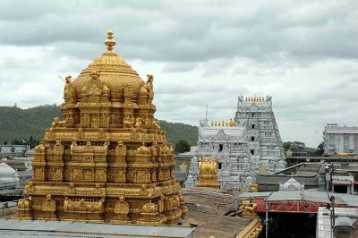
Famous for its laddu, which temple in Andhra Pradesh has the roof of its sanctum sanctorum covered in gold?


Ananda Nilayam (Abode of Happiness) is the glittering gold-plated gopuram of the Sanctum Sanctorum of the Tirumala Venkateswara Temple. "Vimana" is the style of architecture that Hindu temples followed. The Ananda Nilaya Vimanam is a three-tiered canopy.


The Temple is dedicated to Venkateswara, a form of Vishnu, who is believed to have appeared here to save mankind from trials and troubles of Kali Yuga. Hence the place has also got the name Kaliyuga Vaikuntham and the Lord here is referred to as Kaliyuga Prathyaksha Daivam. The temple is also known by other names like Tirumala Temple, Tirupati Temple, Tirupati Balaji Temple. Venkateswara is known by many other names: Balaji, Govinda, and Srinivasa


It is the richest temple in the world in terms of donations received and wealth. The temple is visited by about 50,000 to 100,000 pilgrims daily (30 to 40 million people annually on average), while on special occasions and festivals, like the annual Brahmotsavam, the number of pilgrims shoots up to 500,000, making it the most-visited holy place in the world. In 2016, it was reported that 27.3 million pilgrims visited the temple.


Picture Credit : Google


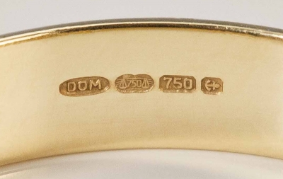
A mark is stamped on gold, certifying its standard purity. What is it called?


It has now become mandatory for all jewellers to hallmark gold jewellery. The Ministry of Consumer Affairs, Food and Public Distribution issued a notification on January 14 stating that it will give one year's time to jewellers and retailers to register themselves with the Bureau of Indian Standards (BIS) and clear their old stock.


Hallmarks are often confused with "trademarks" or "maker's marks". A hallmark is not the mark of a manufacturer to distinguish his products from other manufacturers' products: that is the function of trademarks or makers' marks. To be a true hallmark, it must be the guarantee of an independent body or authority that the contents are as marked. Thus, a stamp of "925" by itself is not, strictly speaking, a hallmark, but is rather an unattested fineness mark.


In some nations, such as the UK, the hallmark is made up of several elements, including: a mark denoting the type of metal, the maker/sponsor's mark and the year of the marking. In England, the year of marking commences on 19 May, the feast day of Saint Dunstan, patron saint of gold- and silversmiths. In other nations, such as Poland, the hallmark is a single mark indicating metal and fineness, augmented by a responsibility mark (known as a sponsor's mark in the UK). Within a group of nations that are signatories to an international convention known as the Vienna Convention on the Control of the Fineness and the Hallmarking of Precious Metal Objects, additional, optional yet official, marks may also be struck by the assay office. These can ease import obligations among and between the signatory states. Signatory countries each have a single representative hallmark, which would be struck next to the Convention mark that represents the metal and fineness.


Picture Credit : Google


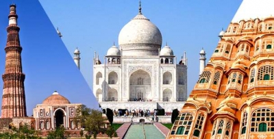
A tourist circuit connecting which three cities is called the golden triangle of India?


India's golden triangle is a tourist circuit which connects the national capital Delhi, Agra and Jaipur. The Golden Triangle is so called because of the triangular shape formed by the locations of New Delhi, Agra and Rajasthan on a map. The trips usually start in Delhi moving south to the site of Taj Mahal at Agra, then west, to the desert landscapes of Rajasthan. It is normally possible to do the trip by coach or private journey through most tour operators. The Golden Triangle is now a well traveled route providing a good spectrum of the country's different landscapes. The circuit is about 720 km by road. Each leg is about 4 to 6 hours of drive. The Shatabdi express train also connects Delhi with Agra and Jaipur.


The three cities of the Golden Triangle are unique in their own way. Delhi, the capital city, is more sophisticated and modern, with a cosmopolitan culture, and is one of the busiest cities in India. The city of Agra, on the other hand, reflects the grandeur of the Mughal Empire, showcasing their rich architectural preference and styles. Jaipur is among the most dazzling and colorful cities that speaks of the mighty Rajputs and their opulent lifestyles, culture and heritage.


Some of the major attractions in Delhi are Red Fort, Jama Masjid, Humayun's Tomb, Qutab Minar, Chandni Chowk, Lodhi Gardens, Lotus Temple, India Gate, Gandhi Smriti and the Garden of Five Senses.


Agra is famous for the Taj Mahal, which is the Seventh Wonder of the World. It is the main attraction of the circuit tour. The Taj Mahal is a mausoleum built by Emperor Shah Jahan of the Mughal Dynasty, in memory of his wife Mumtaz Mahal.


Jaipur, famously known as the Pink City, boasts of being a major tourist destination with attractions such as City Palace, Hawa Mahal, Nahargarh Fort, Amber Fort and Palace, Jaigarh Fort, Jantar Mantar, Government Central (Albert Hall) Museum, Dera Amer Elephant Safari and Galta Monkey Temple.


Picture Credit : Google


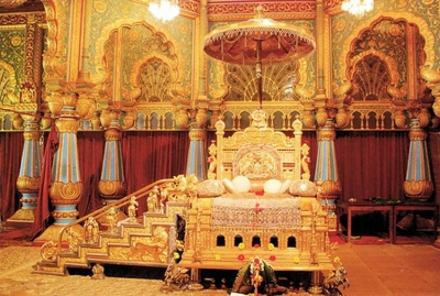
The golden throne is one of the attractions of which palace in the country?


The Golden Throne or Chinnada Simhasana or Ratna Simhasana in Kannada, was the royal throne of the rulers of the Kingdom of Mysore. It is one of the main attractions of Mysore Palace. It is kept for public viewing only during Dasara festival and on the rest of the days, it is disassembled and kept in safe lockers of the palace. The Throne comprises a main seat, steps leading to the main seat, and a golden umbrella over the main seat. The throne is carved out of figwood and decorated with ivory plaques. It was embellished with jewellery, gold, precious stones and silver figurines by "Swarnakala Nipuna" Singannacharya. 


According to tradition, the throne belonged to the Pandavas of Mahabharata fame and was in Hastinapura. Kampilaraya brought this throne from Hastinapura to Penugonda, now in Andhra Pradesh, where it was kept underground. In 1336 AD, Vidyaranya, the royal preceptor of the Vijayanagar kings, showed the spot where it was buried to Harihara I, one of the founders of the Vijayanagar empire, who retrieved the throne. The throne was then used by the Vijayanagar kings at Anegondi for more than a century and a half. During the early part of the 17th century the Governor of Vijayanagar rulers at Srirangapatna obtained the throne. In 1609, the governor Srirangaraya gave the throne to Raja Wodeyar. In 1610, Raja Wodeyar ascended the throne. Inaugurated the Dasara festivities. Epigraphical evidence shows that this royal throne was in the possession of Chikkadevaraya Wodeyar in 1699.


Picture Credit : Google


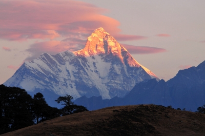
Which is the second highest mountain in India?


Nanda Devi is the second highest mountain in India after Kangchenjunga and the highest located entirely within the country. (Kangchenjunga, which is higher, is on the border of India and Nepal.) It is the 23rd-highest peak in the world. It was considered the highest mountain in the world before computations in 1808 proved Dhaulagiri to be higher. It was also the highest mountain in India until 1975 when Sikkim, the state in which Kangchenjunga is located, joined the Republic of India.


Nanda Devi is a two-peaked massif, forming a 2-kilometre-long (1.2 mi) high ridge, oriented east-west. The western summit is higher, and the eastern summit, called Nanda Devi East, (locally known as Sunanda Devi) is the lower one. The main summit stands guarded by a barrier ring comprising some of the highest mountains in the Indian Himalayas, twelve of which exceed 6,400 metres (21,000 ft) in height, further elevating its sacred status as the daughter of the Himalaya in Indian myth and folklore. The interior of this almost insurmountable ring is known as the Nanda Devi Sanctuary, and is protected as the Nanda Devi National Park. Nanda Devi East lies on the eastern edge of the ring (and of the Park), at the border of Chamoli, Pithoragarh and Bageshwar districts.


Picture Credit : Google


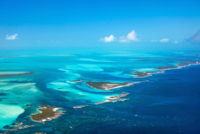
Which is the second deepest ocean?


Atlantic Ocean, body of salt water covering approximately one-fifth of Earth’s surface and separating the continents of Europe and Africa to the east from those of North and South America to the west. The ocean’s name, derived from Greek mythology, means the “Sea of Atlas.” It is second in size only to the Pacific Ocean.


Although not the largest of the world’s oceans, the Atlantic has by far the largest drainage area. The continents on both sides of the Atlantic tend to slope toward it, so that it receives the waters of a great proportion of the major rivers of the world; these include the St. Lawrence, the Mississippi, the Orinoco, the Amazon, the Río de la Plata, the Congo, the Niger, the Loire, the Rhine, the Elbe, and the great rivers draining into the Mediterranean, Black, and Baltic seas. In contrast to the South Atlantic, the North Atlantic is rich in islands, in the variety of its coastline, and in tributary seas. 


Picture Credit : Google


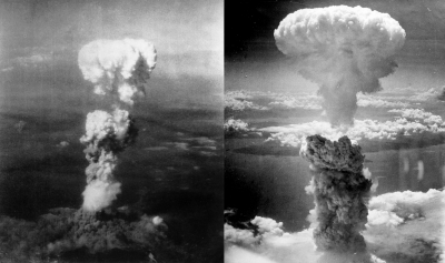
On which two Japanese cities the U.S. dropped atomic bombs?


The United States detonated two nuclear weapons over the Japanese cities of Hiroshima and Nagasaki on August 6 and 9, 1945, respectively, with the consent of the United Kingdom, as required by the Quebec Agreement. The two bombings killed between 129,000 and 226,000 people, most of whom were civilians, and remain the only uses of nuclear weapons in armed conflict.


By August 1945, the Allies' Manhattan Project had produced two types of atomic bombs, and the 509th Composite Group of the United States Army Air Forces (USAAF) was equipped with the specialized Silverplate version of the Boeing B-29 Superfortress that could deliver them from Tinian in the Mariana Islands. The Allies issued orders for atomic bombs to be used on four Japanese cities on July 25. On August 6, one of the modified B-29s dropped a uranium gun-type bomb ("Little Boy") on Hiroshima. Another B-29 dropped a plutonium implosion bomb ("Fat Man") on Nagasaki three days later. The bombs immediately devastated their targets. Over the next two to four months, the acute effects of the atomic bombings killed between 90,000 and 146,000 people in Hiroshima and 39,000 and 80,000 people in Nagasaki; roughly half of the deaths in each city occurred on the first day. 


Scholars have extensively studied the effects of the bombings on the social and political character of subsequent world history and popular culture, and there is still much debate concerning the ethical and legal justification for the bombings.


Picture Credit : Google


Which is the second largest continent (by size)?


Africa is No. 2 on both lists: population and size. In area, it spans 11.6 million square miles (30 million square kilometers). Its population is estimated at 1.3 billion. Along with Asia, these two continents are forecast to be the highest areas of world population growth in the coming decades.


Africa is home to the longest river in the world, the Nile. It stretches 4,100 miles (6,600 kilometers) from Sudan to the Mediterranean Sea.


The continent is cut almost equally in two by the Equator, so that most of Africa lies within the tropical region, bounded on the north by the Tropic of Cancer and on the south by the Tropic of Capricorn. Because of the bulge formed by western Africa, the greater part of Africa’s territory lies north of the Equator. Africa is crossed from north to south by the prime meridian (0° longitude), which passes a short distance to the east of Accra, Ghana.


Africa contains an enormous wealth of mineral resources, including some of the world’s largest reserves of fossil fuels, metallic ores, and gems and precious metals. This richness is matched by a great diversity of biological resources that includes the intensely lush equatorial rainforests of Central Africa and the world-famous populations of wildlife of the eastern and southern portions of the continent. Although agriculture (primarily subsistence) still dominates the economies of many African countries, the exploitation of these resources became the most significant economic activity in Africa in the 20th century.


Picture Credit : Google


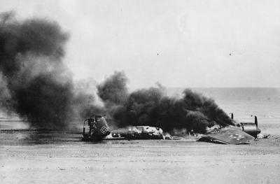
The invasion of one European country by another started World War II. Which are the countries?


After securing the neutrality of the Soviet Union (through the August 1939 German-Soviet Pact of nonaggression), Germany started World War II by invading Poland on September 1, 1939. Britain and France responded by declaring war on Germany on September 3. Within a month, Poland was defeated by a combination of German and Soviet forces and was partitioned between Nazi Germany and the Soviet Union.


The relative lull in fighting which followed the defeat of Poland ended on April 9, 1940, when German forces invaded Norway and Denmark. On May 10, 1940, Germany began its assault on western Europe by invading the Low Countries (Netherlands, Belgium, and Luxembourg), which had taken neutral positions in the war, as well as France. On June 22, 1940, France signed an armistice with Germany, which provided for the German occupation of the northern half of the country and permitted the establishment of a collaborationist regime in the south with its seat in the city of Vichy.


Post-war Germany would be divided into four occupation zones, to be controlled by the Soviet Union, Britain, the United States and France. On the divisive matter of Eastern Europe’s future, Churchill and Truman acquiesced to Stalin, as they needed Soviet cooperation in the war against Japan.


Picture Credit : Google


Which is the second most populous State of India?


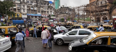
As the home of the Marathi people, Maharashtra is the second-most populous state and third-largest state by area in India. Spread over 307,713 km2 (118,809 sq mi), it is also the world's second-most populous country subdivision. Maharashtra is bordered by the Arabian Sea to the west, the Indian states of Karnataka and Goa to the south, Telangana to the southeast and Chhattisgarh to the east, Gujarat and Madhya Pradesh to the north, and the Indian union territory of Dadra and Nagar Haveli and Daman and Diu to the northwest.


Maharashtra is the most industrialised state in India while state capital Mumbai is India's biggest financial and commercial capital. The state has played a significant role in the country's social and political life and widely considered a leader in terms of agricultural and industrial production, trade and transport, and education. Maharashtra is one of the most developed and prosperous Indian states and continues to be the single largest contributor to the national economy with a share of 15% in the country's GDP.


Picture Credit : Google