WHAT ARE POLES OF INACCESSIBLILITY?

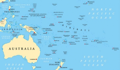
Every continent has a point hardest to reach from the coast of a landmass, either due to tough terrain or untraversable routes, or sheer distance from the coast. A pole of inaccessibility (not to be confused with the North and South Poles), is the point on any continent that is hardest to reach from the coast. There is one on every continent and a couple in the middle of the ocean! The Arctic pole of inaccessibility is a few hundred kilometres from the North Pole. Since there is no landmass so far north, the pole is calculated as the northernmost point that is furthest from land. Like the North Pole, it is located on the shifting pack ice of the northern Arctic Sea. The spot in Eurasia that is furthest from the ocean is located north of Ürümqi in northwest China, over 2,400km from the coast in the middle of desert. Both the North American an South American poles as well as the African pole are located near small towns. Two are in the midst of dense jungle and all three are over 1,760km from the nearest coast.  Australian's remotest point is only 900 km from the nearest coast, in the northern Territory.

The Southern pole of inaccessibility (750 km from the South Pole) has a Russian research station built there in 1958. Also known as the Oceanic pole of inaccessibility, Point Nemo, in the South Pacific Ocean, is over 1,400 nautical miles from the three closest islands.

Picture Credit : Google

What are the interesting facts about Croatia?

Croatia is located in the northwestern part of the Balkan peninsula. The country declared its independence from Yugoslavia in 1991. However, it faced four years of war and a decade of authoritarian nationalism under President Franjo Tudjman.

History

Historically, Croatia was a bridge connecting the central European and Mediterranean worlds.

The first Croats settled here around 500 AD. From 1868 till the end of World War II, it was ruled by Hungary and then it became a part of Yugoslavia.

In the early 1990s, Communism collapsed in eastern Europe. While being part of Yugoslavia, different ethnic groups in the Croatian region began to fight for power and independence.

After Croatia declared its independence in 1991, a civil war began between the Croatians and Serbians. The war came to an end with the signing of the Dayton Agreement in December 1995.

After the fall of Communism in Croatia, the government converted the economy from the Yugoslav system of socialist self-management to market-oriented capitalism.

Geography

The country is small, crescent-shaped, and geographically diverse. It has low mountains and highlands near the Adriatic coastline.

There are flat plains near the Hungarian border. Near the mountainous regions, winters are snowy and the summers are mild. The coastal areas have hot, sunny summers and mild winters. The highest mountain here is Dinara, located in the central mountain belt.

Flora and fauna

Due to the country's diverse geography, the flora and fauna are also varied. While on the Dalmatian coast, grapes and olives are grown, Istria is covered with firs, and Slavonia has oak forests.

The country has wolves, bears, hares, foxes, boars, wildcats, and mouflons (wild sheep). The sea life in the Adriatic includes several coral reefs, and underwater caves serve as habitats.

People

There are several ethnic groups in the country. Croats are the largest ethnic group. Serbs are the largest minority group though their population decreased after the 1990s war of independence.

The other populations include Bosnian Muslims, Hungarians, Italians, and Slovenes as well as some Albanians, Austrians, Bulgarians, Czechs, Germans, and other nationalities.

The diversity in population has influenced its cuisine. Along the coast, fish is served with blitva, which is a Swiss chard mixed with potatoes and garlic in olive oil.

The country's literary history dates back to about 1100. The first book in the Croatian language was Hrvoje's Missal, a liturgical text printed in 1483.

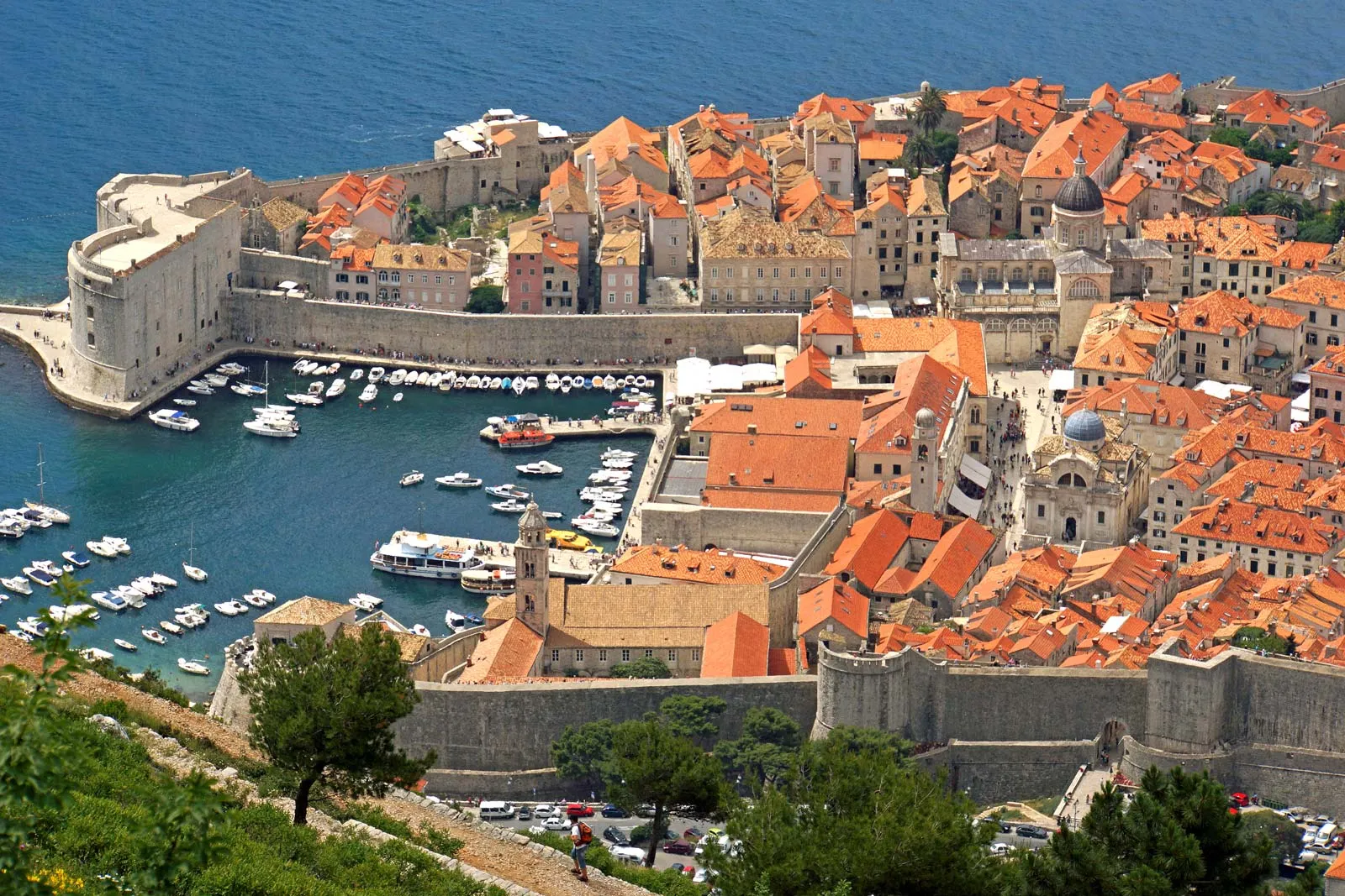
UNESCO has included several sites on its World Heritage List, such as the old city of Dubrovnik and Split, which contains the ruins of the palace of Roman emperor Diocletian.

Sports in Croatis dates back to the Roman times (medieval knights' tournaments). The organised sport began in the country in late 19th Century, when the first sports associations were founded. In 1874, Hrvatski Sokol (Croatian Falcon) was founded. It soon became the largest organisation in the country promoting modern gymnastics and other branches of sports such as cycling, fencing, equestrianism, athletics, skating, tennis, etc.

Government

By early 2003, Slovenia became the second former Yugoslav republic to have applied for membership in the European Union (EU). On July 1, 2013, the country became the 28th member state of the EU.

The President is elected by a popular vote to a five-year term. However, his role is mainly ceremonial. Though the President appoints the Prime Minister, the parliament approves the nomination.

Picture Credit : Google 
HOW DO WE KNOW THAT ICE ONCE COVERED AN AREA?

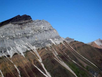
A study of rocks found in an area reveals much about its past. The debris and way that sediments have been changed and distorted gives evidence of ice covering that area. Also, land eroded by ice shows certain typical landforms such as glaciated valleys with cirques, arêtes and horns. All these indicate the presence of ice sometime in the past.

Sea ice may have covered the Earth's surface all the way to the equator hundreds of millions of years ago, a new study finds, adding more evidence to the theory that a "snowball Earth" once existed.

The finding, detailed in the March 5 issue of the journal Science, also has implications for the survival and evolution of life on Earth through this bitter ice age.

Geologists found evidence that tropical areas were once covered by glaciers by examining ancient tropical rocks that are now found in remote northwestern Canada. These rocks have moved because the Earth's surfaces, and the rocks on it, are in constant motion, pushed around by the roiling currents of the planet's interior, a process called plate tectonics.

Credit: Live Science

Picture Credit: Google

WHERE IS THE LARGEST SEAGRASS MEADOW FOUND?

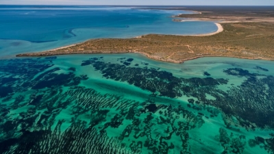
Scientists have discovered the world's largest plant off the Australia coast- a seagrass meadow that has grown by repeatedly cloning itself. Genetic analysis has revealed that the underwater fields of waving green seagrass are a single organism covering 180 sq.km. through making copies of itself over 4,500 years.

Scientists confirmed that the underwater meadow was a single organism by sampling and comparing the DNA of seagrass shoots across the bed, wrote Jane Edgeloe, a study co-author and marine biologist at the University of Western Australia.

A variety of plants and some animals can reproduce asexually. There are disadvantages to being clones of a single organism. such as increased susceptibility to diseases- but "the process can create hopeful monsters" by enabling rapid growth, the researchers wrote.

The scientists call the meadow of Poseidon's ribbon weed "the most widespread known clone on Earth", covering an area larger than Washington, the US.

Though the seagrass meadow is immense, it's vulnerable. A decade ago, the seagrass covered an additional seven square miles, but cyclones and rising ocean temperatures linked to climate change have recently killed almost a 10th of the ancient seagrass bed.

Did you know?

  • The species is commonly found along parts of Australia's coast, and grows "like a lawn" up to 35 cm a year, Which is how they arrived at this plant's age.
  • This specific plant is believed to have spread from a single seed.
  • The plant is hardy, growing in different types of conditions within its present location - from a variety of temperatures and salinities to extreme high light conditions, all of which would have been very stressful to most other plants.
  • A place in the Guinness World Records

The Poseidon's ribbon weed has entered the Guinness World Records as the "largest single living organism based on area". The weed has claimed its title from a honey mushroom, which is spread over 2,385 acres in the U.S. The mushroom is still "the world's largest fungus".

Picture Credit : Google 

WHAT IS SPECIAL ABOUT THE GEOGRAPHIC SOUTH POLE?

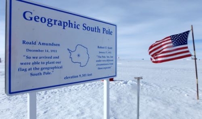
The geographic South Pole in Antarctica is the only place on earth where you can time travel! All lines of longitude converge at this exact point, so you are literally standing in all 24 time zones. You can step from today into yesterday and back into tomorrow! Since Antarctica is largely uninhabited, the continent is not officially divided into time zones. Research stations use the time zone of the country that operates them, while others observe the local time of countries nearby officially divided into time zones. Research stations use the time zone of the country that operates them, while others observe the local time of countries nearby.

What is a time zone?

A time zone can be described as a region of the Earth that observes a standard time for several purposes, including commercial, legal, and social. Time zones often follow the boundaries of a country and its subdivisions since it is convenient for places in close proximity to observe the same time. Time zones on land are usually offset from Coordinated Universal Time (UTC). The Earth’s rotation means that time zones are determined by the lines of longitude that connect the North and South Poles, and divide the globe into different time zones. A country or region may have multiple time zones. For example, the United States is spread across six time zones. However, since all lines of longitude converge at the poles, it means that the poles are technically located within all time zones simultaneously. 

Time at the geographic poles.

In most parts of the globe, lines of longitude determine the local time, such that the specific time is synchronized to the position of the Sun in the sky. However, this does not apply at the North and South Poles, where the rising and setting of the Sun occurs only once a year. At the North Pole, the sun is continuously above the horizon in the summer and below the horizon during winter. The Sun rises during the March equinox and reaches sunset around the September equinox. The South Pole does not receive any sunlight from March until September, while the Sun is continuously above the horizon from September until March, meaning that the pole experiences one of the coldest climates in the world.

How is time determined at the geographical poles?

While there are no permanent human settlements at the poles and no specific time zone has been assigned to either pole, explorers and polar expeditions choose to follow any time zone deemed convenient. Therefore, a group of explorers may choose to observe the same time zone as their country of origin or may opt to use Greenwich Mean Time. For example, a group working at the McMurdo Station in the South Pole followed the local time in New Zealand local time (UTC+12 or 13).

Credit : World atlas 

Picture Credit : Google 

Which is world's longest trail?

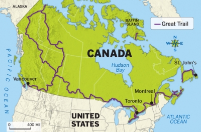
At 24,000 km long, the Great Trail in Canada is the world's longest recreational trail network of roadways, greenways and waterways. It has individual sections for walking, cycling, paddling. horseback riding and cross-country skiing.

Twenty-five years ago, Great Trail founders Pierre Camu, Bill Pratt and Paul LaBarge came up with the idea of linking Canada’s various trail networks into one mega-trail to celebrate the nation’s 125th birthday. Since then, tens of millions of dollars have been spent on trail building, signage and negotiations with landowners and local governments. Four hundred and seventy-seven groups helped to create the trail’s 432 sections, which pass through 15,000 communities.

In September of 2016, the trail was only 85 to 90 percent connected,  Over the last year, however, organizers made a monumental push to work with counties and municipalities to negotiate interim solutions for the missing bits of trail.  Not everyone is impressed by the Great Trail, former known as the Trans-Canada Trail, however, according to Jason Markusoff at MacLean’s. Reportedly, the route falls significantly short of its original goal of being an off-road trail, with only around 4,900 miles of the route, or 32 percent, composed of off-road trails. About 5,340 miles of the trail are along roads or the shoulders of highways, while 3,770 miles are water trails and 1,110 miles share the trail with ATVs.

Picture Credit : Google 

WORLD ATLAS - NORTHERN AFRICA


The northern half of Africa stretches down from the fertile coast bordering the Mediterranean Sea, through vast areas of desert and savanna, into the forests of the west and central Africa. Apart from the Atlas Mountains, the Ethiopian Highlands and Saharan ranges, much of the region is a level plateau.


In the far north of Africa, the countries bordering the coast benefit from natural resources of oil and gas. They also rely on tourism and the manufacture of textiles and carpets. The population is mostly Arabs. Berbers, an ancient native people, live in the uplands of Morocco.


South of the Sahara, agriculture is the primary industry of many countries. Rivers such as the Nile, Niger and Senegal provide essential water with which to irrigate crops. However, in many countries such as Mauritania and Mali, drought is a recurrent problem. In the driest areas, nomadic cattle-herders travel vast distances in search of good grazing.


There are many different peoples living in Northern Africa. Conflict between them often leads to long and devastating wars. The combination of war, drought and widespread poverty has led to terrible famines in Ethiopia and Sudan.


West Africa has a wetter climate, and crops such as coffee, bananas, cocoa, groundnuts and citrus fruits are grown. For many years, timber has been an important product of countries such as the Cote d’Ivoire, but this was carried out at such a rate that vast areas of the forest have now disappeared. Mining of oil and metal ores is a rich resource, but due to poor government and frequent wars, many countries are still impoverished.


Many people in Northern Africa live in small towns or villages, producing just enough food and goods for themselves. Others crowd into the cities, looking for work. They often have to live in very poor conditions on the outskirts of the city.


Picture Credit : Google


WORLD ATLAS - SOUTHERN AFRICA


The Congo basin covers much of central Africa. Here, the mighty Congo River winds through dense rainforest, where animals such as the rare mountain gorilla and a host of bird species live.


 To the south and east are high plateaux, with a cooler, drier climate. Much of the land is flat grassland, called savanna, where animals such as giraffes, elephants and lions roam. In the southwest, the savanna gives way to areas of hot, dry desert. In the east, deep valleys, high volcanic mountains and huge lakes have formed along a split in the Earth’s crust, known as the Great Rift Valley.


Southern Africa is rich in natural resources such as oil, metals (particularly copper and gold) and diamonds. Mining is therefore a vitally important industry. Tourism is also important to the savanna regions, where large national parks have been set up to protect the wildlife. In the eastern highlands, crops of tea and coffee are grown for export. Cattle are farmed for their meat and dairy products.


Outside South Africa and the Copper Belt (southern Congo and northern Zambia), large industrial areas are scarce. Countries such as Angola and Mozambique, with fertile land and rich resources, are nevertheless poverty-stricken due to years of civil war. Many people are farmers, and produce only enough food for themselves.


There are many hundreds of different tribal groups in Southern Africa, with many different languages and customs. Violent clashes between rival groups are frequent. In the worst affected regions, millions of people have fled to neighbouring countries to escape the conflicts.


Picture Credit : Google


WORLD ATLAS - AFRICA


The second largest continent after Asia, Africa is almost completely surrounded by water, apart from the narrow point at which it joins on to Asia. The north of the continent is mostly hot, barren desert, edged with coastal areas that are cooler and wetter in winter.


Further south, the desert gives way to areas of flat grassland. The Equator runs right through the centre of Africa. The countries on or close to the Equator are dominated by the largest area of tropical rainforest outside South America. Here the climate is hot and wet.


The rainforest is home to many different plants and animals, including gorillas and chimpanzees. Many rivers weave their way through central Africa. To the east and south are large areas of open grassland scattered with trees, known as savanna. Animals such as elephants, zebra and wildebeest, roam the savanna, along with predators such as lions, wild dogs and hyenas.


AFRICAN PEOPLES


North of the Sahara desert, the people of Africa are mainly Arabs and Berbers, who follow the religion of Islam. South of the Sahara, most people are black. They follow a variety of religions. Much of Africa was at one time controlled by Europe, and today people of European descent still live there, mostly in the south.


Africa exports its natural resources of metals and oil, as well as crops such as coffee and cocoa. However, many African countries are poor compared to the rest of the world. Few have established manufacturing industries. Most people live in the countryside, and rely on producing only enough crops, or farming enough cattle to support their families. They suffer from frequent droughts, floods and periods of starvation. Wars between and within countries also threaten their lives.


SAHARA DESERT


The world’s largest desert, the Sahara stretches across an area of Northern Africa that is almost the size of the USA. It is constantly growing larger as the sparse grassland at its edges dies away. The Sahara is a hot desert, where rain may fail to fall for years on end. During the day, temperatures can reach over 50°C in the shade, but nights are often cold. There are areas of sand that often drift into large dunes, but much of the Sahara is made up of rocky ground and mountains.


Despite these harsh conditions, the Sahara desert is not without life. Animals that are specially adapted for life with little water and intense heat can survive there. Many take shelter in burrows during the day, coming out at night to feed.


People also live in the Sahara desert. Small towns are able to survive around oases in the desert. Groups of nomads also travel across the harsh landscape to trade in the town markets. For thousands of years, they carried their goods and supplies by camel, an animal that can cope extremely well with desert life. It also provided the nomads with milk and meat. Today motor vehicles are more often used to cross the desert.


Picture Credit : Google


WORLD ATLAS - AUSTRALIA


A part from a long range of mountains running down its eastern side, most of Australia is flat, hot and dry. It is rich in natural resources such as coal and minerals including gold, copper and iron. The vast interior, or outback, is mostly desert, or dry scrublands. To the east, this gives way to open grassland - stock-raising country, where Australia’s sheep and cattle ranches, or “stations”, are situated. With its millions of sheep, Australia is the world’s largest producer of wool.


Most Australians live around the coasts, where the climate is cooler and the land fertile. Crops such as wheat and tropical fruits are grown for export, and vineyards produce world-famous wines. A high proportion of people live in the largest cities, such as Sydney, Brisbane and Melbourne. The cities have modern manufacturing industries.


About 200 years ago, the British and other Europeans began to arrive on the shores of Australia. They routed many of the native Australians already living there, and seized their land. Today, much of Australia’s population is of European descent, although there are substantial numbers of immigrants from Asia. The small numbers of native Australians that remain are working to reclaim some of their land and sacred sites.


NEW ZEALAND


Like its neighbour, Australia, New Zealand is a prosperous country. It farms huge numbers of cattle and sheep, producing large quantities of wool, meat and dairy products for export. Its fertile land and warm climate also make it ideal for vineyards and fruit and vegetables. The power of New Zealand’s many rivers, and also the underground heat from volcanic activity on North Island, are harnessed through non-polluting electricity schemes.


The native peoples of New Zealand are the Maoris, who originally came from Polynesia. They still make up about nine per cent of the population, and have retained much of their culture and traditions.


Picture Credit : Google


WORLD ATLAS - JAPAN


Lying off the east coast of mainland Asia, Japan is made up of four large islands, where most of the population live, and thousands of smaller ones. The four main islands are Honshu, Hokkaido, Kyushu and Shikoku. Much of Japan is covered with mountains, some of them volcanic. It is also densely forested. Winter is cold in the north, but the south of the country has mild winters and hot summers.


With limited land available for farming, and a lack of natural resources, Japan has turned to industry and technology for its livelihood. Today, it is a leading producer of cars, ships and electronic goods such as computers, televisions and cameras. It is also a powerful financial centre. Most people live in the cities, several of which have a population of over one million. Their buildings are designed to withstand the earthquakes that frequently occur.


Picture Credit : Google


WORLD ATLAS - OCEANIA


Stretching across a vast region of the Pacific Ocean, Oceania is made up of the large island of Australia (almost a continent in itself) together with New Zealand, Papua New Guinea and thousands of small Pacific islands.


Much of Australia is covered with hot, dry desert and flat, open grassland known as the outback. Most people live in towns and cities near the coasts, especially the south coast. Papua New Guinea, in contrast, is a country of high mountains and dense rainforests. Many tribes of native peoples live in mountain valleys so isolated that they have only recently come into contact with the outside world.


New Zealand is made up of two islands, the north of which is warm and volcanic, while the south island is cooler, with mountains and forests. The grassy lowlands are fertile, and ideal for farming. The remote position of New Zealand, and also of Australia and Papua New Guinea, means that they are home to animals that are not found anywhere else in the world.


The Pacific islands are the remains of volcanoes that have erupted beneath the ocean. Some islands, such as Hawaii, still have active volcanoes. The islands are grouped together into nations. Some of these are independent, while others, such as New Caledonia, are colonies of European countries or the USA. Many Pacific islands are very beautiful, with rich vegetation and a warm climate. This makes them popular tourist destinations, and also, gives them plenty of fertile land for farming crops.


Picture Credit : Google


WORLD ATLAS - CHINA


The third largest country in the world, China also has the highest population - more than one-fifth of all the people in the world today. The west of the country is mountainous, with bleak deserts and grassland plains or steppes. The deserts are freezing cold in winter. The highest point is Mount Everest, which lies on the border between Tibet and Nepal. Tibet used to be an independent country, but has been occupied by China since the 1950s.


In contrast, the eastern part of China has a warm climate, with fertile soil and river valleys. Great rivers, including the Yangtse and the Huang He, or Yellow River, wind their way from the western mountains to the sea. The Grand Canal, the world’s longest waterway, stretches for 1790 kilometres. Most of the population of China lives in the east. China is a major producer of tea, wheat and sweet potatoes as well as rice, which is grown in the flat, flooded paddy fields of the south. Pigs and poultry are kept everywhere.


Many Chinese cities have populations of more than a million people. Most people live in apartment blocks. China has natural resources such as coal and oil, and also heavy industry such as steel and chemical plants. It is an important producer of textiles, clothing and electronics. Though many people in China are poor, it is a rapidly developing country.


MONGOLIA AND KOREA


Mongolia occupies the grassy plains between the mountains to the north and the Gobi desert to the south. Many people still live a nomadic life on the central plains. Mongolia has coal and oil resources.


North and South Korea are both mountainous and forested, but while North Korea has little contact with the outside world, and relies on enormous state-controlled farms, South Korea has thriving, modern industries and many trade links.


Picture Credit : Google


WORLD ATLAS - SOUTHEAST ASIA


The southeast corner of mainland Asia, together with thousands of islands further south, makes up the region of Southeast Asia. On the mainland are the mountainous, forested countries of Thailand, Laos, Vietnam and Cambodia. Great rivers flow through the region, creating fertile valleys where large quantities of crops such as rice and tropical fruits are grown. Thailand also has successful tourist and manufacturing industries. Cambodia, Vietnam and Laos have been devastated by war, although Vietnam now has a growing industrial economy.


Malaysia is made up of the mainland Malay Peninsula, and most of northern Borneo. Southern Borneo, together with other islands including Sumatra and Java, is part of Indonesia. The climate is hot and wet, with areas of dense rainforest that are home to many kinds of plants and animals. Malaysia and Indonesia are rich in natural resources such as oil, gas and rubber. They also have strong manufacturing industries.


North of Borneo are the Philippines, thousands of small islands, many of which are uninhabited. Although their country is rich in mineral resources, many people are obliged to leave to find work in other countries. Both the Philippines and Indonesia are frequently threatened by tropical storms, volcanoes and earthquakes.


The small countries of Singapore and Brunei are among the world’s rich countries. While Brunei has huge resources of oil and gas, Singapore is a worldwide centre of manufacturing and business.


Picture Credit : Google


WORLD ATLAS - SOUTHERN ASIA


The Indian subcontinent encompasses India, Pakistan, Bangladesh, Nepal, Bhutan and Sri Lanka. Much of the northern region is mountainous, with the Himalaya and Karakoram ranges forming a border with the rest of Asia. A region of desert covers eastern Pakistan and northeast India, bordering areas of more fertile land, where farmers grow rice and cotton. The Ganges valley is one of the most intensely cultivated regions in the world. Sri Lanka has large tea plantations, and is a popular tourist resort.


Southern Asia is home to many peoples, with thousands of different languages and several religions. But many people are also very poor. Most are farmers who rely on the monsoon rains to water their crops. They suffer badly when there are droughts or floods, especially in low-lying countries such as Bangladesh. Years of civil war have also added to the poverty in Afghanistan and Burma.


However, some Southern Asian countries are becoming more and more industrialized. India has an important manufacturing industry, producing textiles, clothing and machinery. Its large cities are overcrowded with people who have come from the countryside looking for work.


Picture Credit : Google