Why is Roopkund called Skeleton Lake?

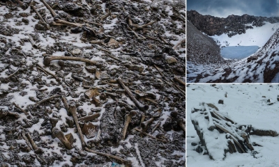
During World War II. an Indian forest Ranger called Hari Kishan Madhwa made a morbid discovery in a remote glacier lake in the Himalayas in Uttarakhand. Something strange was visible in its clear water. On closer inspection, it was revealed that the lake was full of human skeletons. It came to be known as Roop Kund or Skeleton Lake. A DNA sample of 38 skeletons showed that they came from three genetically distinct groups. Who were these people? When did they die? How did they die? Where did they come from?

One old theory associates the remains to an Indian king, his wife and their attendants, all of whom perished in a blizzard some 870 years ago.

Another suggests that some of the remains are of Indian soldiers who tried to invade Tibet in 1841, and were beaten back. More than 70 of them were then forced to find their way home over the Himalayas and died on the way.

Yet another assumes that this could have been a "cemetery" where victims of an epidemic were buried. In villages in the area, there's a popular folk song that talks about how Goddess Nanda Devi created a hail storm "as hard as iron" which killed people winding their way past the lake. India's second-highest mountain, Nanda Devi, is revered as a goddess.

Earlier studies of skeletons have found that most of the people who died were tall - "more than average stature". Most of them were middle-aged adults, aged between 35 and 40. There were no babies or children. Some of them were elderly women. All were of reasonably good health.

Also, it was generally assumed that the skeletons were of a single group of people who died all at once in a single catastrophic incident during the 9th Century.

Scientists genetically analysed and carbon-dated the remains of 38 bodies, including 15 women, found at the lake - some of them date back to around 1,200 years. They found that the dead were both genetically diverse and their deaths were separated in time by as much as 1,000 years.

But more interestingly, the genetics study found the dead comprised a diverse people: one group of people had genetics similar to present-day people who live in South Asia, while the other "closely related" to people living in present-day Europe, particularly those living in the Greek island of Crete. Also, the people who came from South Asia "do not appear to come from the same population".

Genetic studies found no evidence of the presence of any ancient bacterial pathogen that could provide disease as an explanation for the cause of deaths.

Credit : BBC 

Picture Credit : Google 

Where is Rani-ki-Vav also known as Queen's stepwell located?

Rani-ki-Vav is an underground stepwell located in Patan, Gujarat. Situated on the banks of the river Saraswati, this spectacular stepwell was built in the 11th century AD by Queen Udayamati of the Solanki dynasty in memory of her husband King Bhimdev 1.

A stepwell is a multi-tiered well with water that can be reached by descending a series of steps. Rani-ki-Vav has seven storeys of stairs and hundreds of intricately carved sculptures of Vishnu and other deities adoming its walls. It is over 65m long from the entrance to the well, 20m wide and 27m deep. It was declared a World Heritage Site by UNESCO in 2014. Did you know the site, before being unearthed by the Archaeological Survey of India in the 1980s, remained covered in mud and slush because of it being flooded by the river Saraswati for around 800 years?

Step wells of India have always mesmerized tourists from far and wide, for their unique architecture and carvings. Not only does Rani ki vav in Gujarat belong to this class of picturesque landmarks of India, it also has a special historical beginning to it. Read more to explore and quench your thirst about the ancient architecture of India. If you are travelling here for the first time, you might get confused as you won’t see a tall museum or the remains of a ruin because it is built inside an opening in the ground, which makes it special. The east facing well constructed in seven storeys is approximately 64m long, 20m wide & 27m deep. As you go down, you will see over 800 sculptures in the seven galleries, majority of which are devoted to lord Vishnu. It is amongst the finest step wells in India, and one of the most famous legacies of the ancient capital city. Various pillars and walls which are beautifully sculpted in Maru-Gurjara architectural style are a mesmerizing sight. The lowermost level of the well is blocked by stones and silt now but earlier it was used as an escape route to the neighbouring villages. It is one of the largest and the most sumptuous structures of its type. Rani-Ki-Vav is now considered to be the queen among the step wells of India. It is said that the size of the Rani Ki Vav is so huge that the tourists appear as ants climbing an anthill.

Picture Credit : Google 

Is Meghalaya the wettest place on Earth?

Mawsynram in Meghalaya is the wettest place, based on rainfall in the world. Located in the Khasi Hills, it receives about 11,872mm (nearly 467 inches) of average annual rainfall According to the Guinness Book of World Records, the region received 26,000mm of rainfall in 1985. The mountainous terrain of Mawsynram and the nearby Cherrapunji, the second wettest place, are known for their lush greenery and scenic beauty The "living bridges are one of the most beautiful features of this region. These have been created by the local people by training the roots of rubber trees into natural bridges. With the root systems constantly growing, these bridges are self-sustaining.

Primarily due to the high altitude, it seldom gets truly hot in Mawsynram. Average monthly temperatures range from around 11 °C in January to just above 20 °C in August. The village also experiences a brief but noticeably drier season from December until February, when monthly precipitation on average does not exceed 30 millimetres (1.2 in). The little precipitation during the village's "low sun" season is something that is shared by many areas with this type of climate.

Three reasons can be cited for high rainfall at Mawsynram:

The warm moist winds of the northward-moving air from the Bay of Bengal during the monsoon, which cover an extensive area but are forced to converge into the narrower zone over the Khasi Hills, thus concentrating their moisture.
The alignment of the Khasi Hills (east to west) places them directly in the path of the airflow from the Bay of Bengal, producing a significant uplift (plus cooling, further condensation and thus more rain).
Finally, uplift over the Khasi Hills is virtually continuous in the monsoon period because the lifted air is constantly being pulled up by vigorous winds in the upper atmosphere; hence, the rainfall is more or less continuous.

Credit : Wikipedia 

Picture Credit : Google 

What is so special about Lake Titicaca?

The biggest knitted objects in the world are the 62 self-fashioned Uros Islands in Peru's Lake Titicaca (the world's highest navigable lake at 12,500 feet above sea level).  The most remarkable thing about Lake Titicaca is its floating Islands and the people who live there. Each island is no more than 90 feet wide and is strong enough to hold several hundred people, buildings and boats (balsas). The Uru people collect totora reeds, which grow in the lake, and weave their dense roots together to form sturdy layers called 'khili' (about one to two metres thick). These are anchored with ropes attached to sticks driven into the bottom of the lake. The reeds at the bottom of the islands rot away fairly quickly, so new reeds are added to the top constantly, about every three months. If well maintained, an island can last for 30 years.

The houses and boats of the Uro people are built from the same reeds using a similar technique to that of the islands. They also make handcrafted items that they sell to visitors to the floating islands. About every six months they have to lift up and move their houses and buildings so that they can add another layer to the reeds of the floating island. When the Totora is pulled for construction, part of the root is eaten because it’s a rich source of iodine. It is also used for pain relief, tea and to cure a hangover. Fishing and hunting for birds is one of the main ways of getting food on the islands. The Uros also eat the guinea pigs and ducks that they keep on the islands. Waterbirds are also kept on the island but for helping them fish or for their eggs. On the islands, there is a traditional school and a Christian school that are the main sources of education on the islands. As the kids get older and start looking for university they will likely leave the lake and head to the mainland to study in Puno.

The Uro’s way of living is one to marvel at but is also extremely difficult and steadily disappearing. Many still live in the traditional way, hauling reeds into their boats, reconstructing the islands, heading off onto the lake to fish, but many of the young people are leaving and start a different life on the mainland. Daily life here depends mostly around the reeds that grow in the lake, they provide food, housing and transportation.  It is a life of hard work and long days in a harsh climate.

In recent years, tourism has become an important part of the Uro economy. People have opened their homes and welcomed visitors from all over the world. Their unique lifestyle and breathtaking Lake Titicaca make the floating islands a must when passing Puno.

Picture Credit : Google 

Does Neelakurinji bloom every year?

The Neelakurinji (Strobilanthes kunthianus) shrub flowers only once every 12 years. The phenomenon occurred this year and will last till October. Plants that bloom at long intervals like Neelakurinji are known as plietesials. The shrub grows to a height of 30-60 cm and grows profusely across the shoal grasslands of the Western Ghats. The brilliant blue colour of Kurinji has given the Nilgiri Hills in Tamil Nadu the name 'Nilgiri' meaning 'Blue mountains'. Kerala's Munnar (Anamalai Hills, the Agali Hills and Eravikulam National Park) records the highest number of Neelakurinji plants across India, spreading across 3,000 hectares. Apart from being a feast for the eyes, the flowers also provide sustenance for butterflies, insects and honeybees in the region. The honey from Neelakurinji is said to be medicinal.

 ‘Strobilanthes kunthianus’ is the scientific name of Neelakurinji. The name is actually derived from the Kunthi River which nourishes the expanse of the renowned grasslands and valleys. Kurinji flower is considered to be a symbol of desire for love and happiness for the poets and for the tribal; it is the symbol of self awakening of a woman. The Neelakurinji blossoming is spread across 3,000 hectares of rolling hills which is covered in purple/blue colors. Each plant reproduces once in its life span and then dies after flowering. 

We might have seen or read about a number of blooming valleys and flower-laden grasslands all over the world, but there are many reasons that make Munnar and its Neelakurinji exceptional. The peculiarity of Munnar Neelakurinji is its uniqueness. The flower blooms only in Munnar and nowhere else. Even though the plants are found in a sparse amount in other southern hill stations, the one in Munnar is plentiful, rambling magically across its green mountains.

Picture Credit : Google 

Which school students write with both hands?

Veena Vadini School in Singrauli, Madhya Pradesh, is India's only 'ambidextrous' school whose 300 students write using both hands together at the same time. These students have a high speed of writing with both hands and can finish a three-hour long exam in one or one and half hours! When a new student joins the school, he/she holds the pen with one hand, and is taught to use the other hand after a month. After that, they are taught to use both hands together. B. P. Sharma, founder and principal of the school, was inspired to start the school after reading about the first President of India, Dr Rajendra Prasad, who was ambidextrous.

 Only 1 in 100 people can write with both hands but at the Veena Vadini School in Singrauli, Madhya Pradesh, all 300 students are ambidextrous.
Their training starts from class 1 and by class 3, they become comfortable enough to write with both hands.
The students are taught 6 different languages including Roman and Arabic and students of class 8 can easily write 2 different scripts at the same time. BP Sharma, the founder, states that Dr. Rajendra Prasad, India’s first president, who was Ambidextrous, was the inspiration behind the initiative. He also claims that his students take at only 1.5 hours to complete a 3 hour exam.

Credit : Our Time 

Picture Credit : Google 

Which is India's first solar powered city?

Diu is now India's first and only city that is completely solar powered and the first Smart City in India to run on 100% renewable energy. A 9-megawatt solar park has been built in Fudam area, spread over 50 acres, and solar panels have been installed on the rooftops of government buildings. Diu's peak time demand for electricity goes up to 7 megawatts and it generates about 10.5 megawatts of electricity from solar energy daily.

Diu is all set to have four windmills by 2019 which would generate 6.8 megawatts energy. With a combination of solar and wind energy powering it, Diu will become an energy self-sufficient island.

Solar installed capacity in India has reached 20 GW in February 2018, expanding the solar-generation capacity by eight times from 2,650 MW on 26 May 2014 to over 20 GW as on January 31, 2018.

Andhra Pradesh, Rajasthan, Tamil Nadu, Gujarat, Maharashtra, Madhya Pradesh, Kerala are some of the states with solar cell panel rooftops.

In order to conserve energy and curb itself from heavy electricity export bills, most populated countries like China and India are planning to use solar panel rooftops.

China leads the race in solar energy, followed by Japan, Germany, United States, Italy, United Kingdom, India, France, Australia, Spain, respectively, among many others.

Credit : India Today 

Picture Credit : Google 

What is the oldest continuously running restaurant in the world?

Sobrino de Botín in Madrid, Spain, is the oldest running restaurant in the world, according to the Guinness Book of Records. Open since 1725, the restaurant has kept the flame burning in the oven continuously for 293 years, never to be extinguished. World’s oldest restaurant still in operation. At the time that the restaurant opened (in the ground floor of an inn), it was actually up to the guests to bring their own meat and ingredients, which were then cooked in the eatery’s facilities. After the original owners died childless, the restaurant passed to their nephew, which is when it got its current name, which translates to “Nephew of Botin,” of course.

Over the next 200-plus years, the trends of the city changed, but Sobrino de Botin never stopped cooking (after it was able to start cooking for for people that is). Today the restaurant covers four floors of seating, each with its own Spanish theme, from the brick cellar to the fancier Felipe IV room. Even as the tourists began to flock to the restaurant, as will happen once Guinness gets its paws on you, the cuisine has stayed remarkably true to its Spanish roots, with the whole suckling pig, which is prepared in a brick oven, being the standout dish. 

The Sobrino de Botin likely saw its finest moment when it was mentioned by Ernest Hemingway in The Sun Also Rises, and it is rumored that the famous artist Francisco de Goya worked there as a young man. However, its legacy is clearly thanks to its astounding age rather than to its ties to art and literature.

Credit : Slate.com

Picture Credit : Google 

What kind of country is Kiribati?

Kiribati, an island chain in the Pacific Ocean, is the only country in the world that is situated within all four hemispheres of the globe.

Despite having a population of 120,000 and a land mass of 811 squared kilometres, there is almost 4000 kilometres between the easternmost and westernmost parts of Kiribati – which is almost as wide as Australia.

At its highest point, Kiribati stands at a mere height of just eight metres above sea level. Once combined, the 33 stunning, paradisiac islands and atolls make Kiribati the only country in the world to cross all four hemispheres.

With such remoteness comes great challenges. However, since becoming a member association in 2010, the federation have made encouraging progress in their effort to bring badminton to a small nation.

Leading the charge for badminton is Kiribati’s Shuttle Time Co-ordinator Tongoboo Beero, who first came across Shuttle Time in 2012 as a participant. Since then, Tongoboo has powered through the ranks.

In 2019, he was one of 10 trained Shuttle Time teachers who inspired over 600 participants into getting fit and active within their communities with badminton. Earlier this year, he was part of a leadership team who delivered teacher training to expand Kiribati’s Shuttle Time teacher pool. His combined efforts earned his a space in the BWF’s Humans of Shuttle Time campaign.

Moreover, other teachers from Kiribati have noticed a significant rise in popularity. Taonibeia Mwakuti has delivered to more than 50 kids in her local community, which has made a big difference to their lives where there are only a limited number of other activities to keep them engaged.

“We both enjoy the game and can say that we have improved a lot especially with our grips and serving technique” say Mwakuti’s students, Biritia Peter and Eimwa Obwaia.

The complex logistics involved in sending and receiving badminton equipment is one issue for the remote nation. However, finding a suitable badminton court to play on is another.

To combat the lacking badminton facilities, many of the Pacific Islands play outdoors. However, Shuttle Time teachers and students came together recently to paint the lines of a badminton court under a shelter to give a better understanding of the game.

Credit : Badminton Oceania

Picture Credit : Google

Where is the highest post office is located in the world?

The world's highest post office is located in Hikkim in Himachal Pradesh at 14,567 feet above sea level. India has the largest postal network in the world with 1,55,618 post offices.

There are myriad interesting facts about India that the world is not yet aware of and one of among those is that India is the place, where world’s highest post office is located. Yes, there is a beautiful village called Hikkim in the Lahaul-Spiti district of Himachal Pradesh; it is set at an elevation of 4440 m (14,567 ft above sea level). The location is credited for being the World's Highest Post Office with the pin code 172114.

Located about 15 km from the town of Kaza in Spiti Valley, Hikkim has a population that is majorly Buddhist. For most of the months, this place remains cut off from rest of the world due to heavy snowfall over the passes.

In existence from November 5, 1983, the post office too gets shut down for six months due to extreme climatic conditions. Considering the rugged terrains and remoteness of the village, the journey uphill to this post office is quite a tough one. We can just imagine how difficult it must be for the post master, Rinchen Chhering, to send out mails from here.

Rinchen Chhering has been serving at the post office as a Post Master for more than 30 years now. He has been here since the inception of this post office and joined at the young age of 22, just because he was a fast runner and owned a bicycle. For all these years, the man has been doing all work single handedly and loyally, which is simply commendable.

Well, it is quite a long journey from here for the mails. All the posts and letters are firstly sent on foot to Kaza every day. These are then taken to Reckong Peo by bus and then to Shimla. Later, mails are loaded on a train and sent to Kalka; from here, a bus takes the cargo to Delhi. The mails’ journey to its real destination begins from Delhi. So, there is a lot sweat and hard work involved in this entire mail trail!

Is it all not fascinating? The journey, the job, and everything related to this post office that makes it a must-visit in India. If ever you get a chance, do not miss out on exploring this amazing place.

Credit : Times of india 

Picture Credit : Google 

Was the Eiffel Tower once painted yellow?

The Eiffel Tower, first opened to the public on 6 May 1889, is actually painted in three different shades of colour (Eiffel Tower Brown); the darkest shade begins at the base, lightening progressively upto the top, to show off the Tower to maximum advantage against the Parisian skies. The tower is covered with 60 tons of paint every seven years to protect against corrosion.

Its color has varied over the years, from reddish-brown (1889) to ochre-brown (1892), a variation of 5 shades of yellow over its total height (1899), yellow-brown (1907 to 1947), reddish-brown (1954-1961) and since 1968, an “Eiffel Tower brown” of three different tones.

It’s thought that Eiffel chose the colour because he wanted the 324-metre-high tower to reflect the yellowish limestone architecture of the city around it. (But of course, the nod to Olympic gold medals is a nice touch too.)

The work, which began in 2019, is expected to cost a whopping €50 million ($60 million or £44 million) overall. The paint job will be complete by 2022 – well in time for the 2024 Games – and an extensive renovation of the park just to the south is set to follow.

The tower will serve as the backdrop for the triathlon and open-water swimming events in the Seine. The surrounding quais are also expected to play host to a series of shows, concerts and other entertainment.

Credit: Time Out 

Picture Credit : Google 

what is special about Lodhi Garden in delhi?

Trees at Delhi's iconic Lodhi Gardens now have QR codes. It is situated between Khan Market and Safdarjung's Tomb on Lodhi Road. Spread across 90 acres, the garden has around 7,000 species of trees and attracts thousands of nature lovers daily. By scanning the codes with their smartphones, visitors will get details like a tree's age, lifespan, botanical name, blooming season, height, width, flower colour, fruiting period, medicinal usage and origin. Spread over 90 acres, the garden has a national bonsai park, herbal garden, bamboo garden, butterfly zone, lotus and lily pond, peacock hatchery and the tallest (35.5 m) tree in Delhi called 'Buddha Coconut'.

A hundred trees were shortlisted to begin with, in an effort by the government to increase awareness about the environment and urban forestry. Maintained by the NDMC, the Lodhi Garden attracts thousands of visitors daily and houses Archaeological Survey of India-protected structures like Mohammed Shahs Tomb, Tomb of Sikandar Lodi, Shisha Gumbad and Bara Gumbad.

Credit : BusinessToday.in

Picture Credit : Google 


Which lake is the floating lake and the largest freshwater lake?

Loktak Lake in Manipur is the only floating lake in the world and the largest freshwater lake in India. It is famous for its floating phumdis (masses of vegetation, soil and organi matter) of different shapes. The largest phumdi covers an area of 40 sq. km. and is home to Keibul Lamjao National Park, the world's only floating park. The Sendra Tourist Home itself is located on a large phumdi. The Park is home to the endangered brow-antlered deer or Sangai deer, the state animal of Manipur.

Loktak Lake is used for generating hydropower, water supply and irrigation methods. It plays a very essential role in the economical status of the state of Manipur as the livelihood of fishermen living around the place depends on the lake. On 1990, 23 March under the Ramsar Convention the Loktak Lake was named as a wetland of international value by considering its biodiversity and ecological position. The question of where the Loktak Lake is situated is discussed by EduRev Study Group by UPSC Students and solved by the largest student community of UPSC.
Credit :  Sentinelassam

Picture Credit : Google 

Which is the toughest fort in India?

Kalavantin Durg is the world's most dangerous fort. Located between Matheran and Panvel in Maharashtra, at an altitude of 2,300 feet, it is a small cave built into the summit of the natural spire of rock. Built around 530 BC, The journey to the summit starts from the base point in the village of Thakurwadi. The trek to Kalavantin Durg and the Prabalgad Fort, though, takes only about a little over three hours, it requires a tremendous level of concentration and overcoming steep hurdles. The fort is only accessible by zigzag stairs carved into the edges of the rock with no guard rails or ropes, known as the "Climb to Heaven". Tradition holds that it was constructed in honour of a Queen Kalavantin. Every Holi Festival, the Adivasi people of Machi-Prabal village observe the custom of dancing at the top of the fort.

The trail gets notably steeper as you make the move upwards to the top, and there is a sense of vertigo-inducing on the way up – though this doesn’t deter those in pursuit of heart-pounding adventure.

Higher and higher – complete with undulating terrain, rocky patches and waterfalls gushing down the steps – the trail gets even more treacherous until climbers finally reach the pinnacle of the Kalavantin Durg, witness the bird’s eye view and forget all about the arduous ascent.  

Credit : India Times

Picture Credit : Google 

Why Kodinhi village is called twin village?

Kodinhi in Kerala is known as India's Town of Twins. Located in Malappuram district, in a population of nearly 20,000 the presence of more than 450 pairs of twins of different ages still remains a riddle for the scientific world. It has the highest rate of twins in the country, although India has one of the lowest twinning rates in the world. The first association of twins in India, The Twins and Kins Association, was founded here. Like many other villages in Kerala, it is lined with coconut palms, crisscrossed with canals and dotted with rice fields. But, when you go deeper into its narrow streets, you come across a large number of identical faces. You will see many lookalike children, in the school and in the nearby market in this village. The oldest twin living in this village is Abdul Hameed and his twin sister Kunhi Kadia.

Initially, only a few twins were born in the years, but later it accelerated and now twins are being born at a very high speed. In 2008, there were 30 twins out of the 300 children born in good health in the village. But in a few years; their number has reached 60. It is not that the twins born here or their mothers have any physical defects or mental deformities, nothing like that. Women also remain healthy and do not suffer from any kind of deformity. The locals believe that this village has God's special grace which gives birth to more and more twins. 

Credit : India Times

Picture Credit : Google