WHAT IS ZOOPLANKTON?

Zooplankton is an aquatic microorganism that drifts with water currents. It is one of the two types of plankton, the other being phytoplankton, a plant variety. Zooplankton and other small marine animals consume phytoplankton. They themselves become food for fish, crustaceans, and other larger creatures. As an intermediary species, zooplankton plays a crucial role in the aquatic food chain. As ocean waters warm, studies suggest zooplankton is travelling towards the Poles, which could end in an ecological collapse.

Body size has been defined as a "master trait" for plankton as it is a morphological characteristic shared by organisms across taxonomy that characterises the functions performed by organisms in ecosystems. It has a paramount effect on growth, reproduction, feeding strategies and mortality.One of the oldest manifestations of the biogeography of traits was proposed over 170 years ago, namely Bergmann's rule, in which field observations showed that larger species tend to be found at higher, colder latitudes

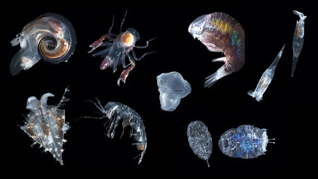
Zooplankton are generally larger than phytoplankton, mostly still microscopic but some can be seen with the naked eye.Many protozoans (single-celled protists that prey on other microscopic life) are zooplankton, including zooflagellates, foraminiferans, radiolarians, some dinoflagellates and marine microanimals. Macroscopic zooplankton include pelagic cnidarians, ctenophores, molluscs, arthropods and tunicates, as well as planktonic arrow worms and bristle worms.

Zooplankton is a categorization spanning a range of organism sizes including small protozoans and large metazoans. It includes holoplanktonic organisms whose complete life cycle lies within the plankton, as well as meroplanktonic organisms that spend part of their lives in the plankton before graduating to either the nekton or a sessile, benthic existence. Although zooplankton are primarily transported by ambient water currents, many have locomotion, used to avoid predators (as in diel vertical migration) or to increase prey encounter rate.

Ecologically important protozoan zooplankton groups include the foraminiferans, radiolarians and dinoflagellates (the last of these are often mixotrophic). Important metazoan zooplankton include cnidarians such as jellyfish and the Portuguese Man o' War; crustaceans such as cladocerans, copepods, ostracods, isopods, amphipods, mysids and krill; chaetognaths (arrow worms); molluscs such as pteropods; and chordates such as salps and juvenile fish. This wide phylogenetic range includes a similarly wide range in feeding behavior: filter feeding, predation and symbiosis with autotrophic phytoplankton as seen in corals. Zooplankton feed on bacterioplankton, phytoplankton, other zooplankton (sometimes cannibalistically), detritus (or marine snow) and even nektonic organisms. As a result, zooplankton are primarily found in surface waters where food resources (phytoplankton or other zooplankton) are abundant.

Just as any species can be limited within a geographical region, so are zooplankton. However, species of zooplankton are not dispersed uniformly or randomly within a region of the ocean. As with phytoplankton, ‘patches’ of zooplankton species exist throughout the ocean. Though few physical barriers exist above the mesopelagic, specific species of zooplankton are strictly restricted by salinity and temperature gradients; while other species can withstand wide temperature and salinity gradients. Zooplankton patchiness can also be influenced by biological factors, as well as other physical factors. Biological factors include breeding, predation, concentration of phytoplankton, and vertical migration.The physical factor that influences zooplankton distribution the most is mixing of the water column (upwelling and downwelling along the coast and in the open ocean) that affects nutrient availability and, in turn, phytoplankton production.

Through their consumption and processing of phytoplankton and other food sources, zooplankton play a role in aquatic food webs, as a resource for consumers on higher trophic levels (including fish), and as a conduit for packaging the organic material in the biological pump. Since they are typically small, zooplankton can respond rapidly to increases in phytoplankton abundance, for instance, during the spring bloom. Zooplankton are also a key link in the biomagnification of pollutants such as mercury.

Zooplankton can also act as a disease reservoir. Crustacean zooplankton have been found to house the bacterium Vibrio cholerae, which causes cholera, by allowing the cholera vibrios to attach to their chitinous exoskeletons. This symbiotic relationship enhances the bacterium's ability to survive in an aquatic environment, as the exoskeleton provides the bacterium with carbon and nitrogen.

Credit : Wikipedia 

Picture Credit : Google 

WHAT IS SEA LEVEL RISE AND WHY IS IT HAPPENING?

As our planet warms, oceans across the globe absorb a large portion of the heat generated. In the process, the water expands, resulting in universal sea-level rise. In addition, the rise is also caused by the melting of glaciers and icebergs. Usually such melting during warmer months and freezing during colder months is a natural phenomenon. However, with global warming, there's more of the former than the latter, leading to alarming sea-level rise, threatening to submerge several cities within just a few decades.

Why does sea level change?

Causes sea level to rise because water expands as it warms up; melting of the world’s ice sheets. A large ice mass, which flows over hills and valleys and occupies a large portion of a continent. The world has only three major ice sheets today (Greenland, West Antarctica, and East Antarctica).

 In Greenland and Antarctica;  melting of smaller around the world; and decrease in the amount of water held on land, for example, in groundwater beneath the land and in reservoirs above the land. Ocean warming accounts for around half of the observed change in sea level (this is often called “thermal expansion”), with the melting of thousands of small glaciers accounting for the other half of the increase in sea level. Since the 1800s, the melting ice sheets in Antarctica and Greenland have contributed relatively little to sea level change. But, these ice sheets are starting to melt faster due to global warming and may push sea level up much more in the future.

How much could sea level rise?

Because of global warming, the thermal expansion of the ocean and glacier melting will continue to play a role in the rise of sea level in the future . If all of the planet’s remaining as small glaciers were to melt, sea level would rise about 50 cm. The amount that thermal expansion can raise sea level in the future will depend on the continued warming of sea water. The largest possible contribution to sea level rise in the future comes from the world’s large ice sheets in Greenland, West Antarctica, and East Antarctica. If these ice sheets melted completely, the level of the oceans would rise about 7 m from the Greenland ice sheet, 5 m from the West Antarctic ice sheet, and 53 m from the East Antarctic ice sheet. This is why many glaciologists (scientists who study ice) focus on how Greenland and Antarctica are changing because of global warming.

How will sea level rise affect the countries of the world?

The effect of ice sheet melting on sea level is different across the world.

So, when the sea level rises, people will be affected in different ways, depending on where they live. The UK is used to occasionally dealing with rising sea level for short periods of time, particularly when there are storms at the same time as when the tides higher than usual. If the IPCC predictions are correct, we must consider the possible increase in sea level on top of natural tidal surges. This will cause dangerously high tides to occur more often in the coming decades, and these future tides might be more destructive than we are used to.

In farming regions near the coast, seawater flooding on land can contaminate the soils with salt, making them less able to support the growth of crops. The salty water may also get into underground stores of fresh water (known as groundwater), which is the source of important drinking water and also for farmers to grow crops.

In coastal cities, sea level rise will cause more flooding to houses, businesses, and while it may seem sensible to consider moving cities away from harmful floods, especially as we know it will likely happen in the future, our cities cost so much to develop that we are more likely to simply try to protect them from rising sea levels. A vision of our cities near the sea involves them with walls facing the ocean several meters high, with the street level of the cities themselves being below the level of the ever rising sea.

Credit : Frontiers for young mind 

Picture Credit : Google 

WHAT IS PELAGIC ZONE?

The pelagic zone is the open region of any lake, sea, or ocean that is away from any part of land, be it the coast or the sea floor. Marine life-from microscopic plankton and tuna to sharks - dominates this area. Due to the abundance of marine creatures, it is a critical space for producing oxygen, regulating climate, and economic activity.

Pelagic Zone Facts

The pelagic zone plays many critical roles that make it essential to life on Earth. Factors that make the pelagic zone unique include:

It covers more than 50% of the Earth in water, more than 3.2 kilometers (2 miles) deep.
It makes up more than 99% of the inhabitable space on our planet.
The deepest part of the ocean, the Mariana Trench, is about 11,000 meters (7 miles) deep.
The open ocean produces more than 50% of the world's oxygen.
It is a critical carbon sink, storing 50 times more carbon dioxide than the atmosphere.
Many of its inhabitants never experience sunlight.

The open ocean provides food, medicine, and economic opportunities for people worldwide. In addition to seafood, ocean harvests provide ingredients for foods like peanut butter and soy milk. Medications for Alzheimer's disease, cancer, heart disease, and arthritis use materials extracted from the ocean, and the United States alone produces $282 billion in ocean-dependent goods and services.

Layers of the Pelagic Zone

The pelagic realm is divided into five distinct regions based on average depth and sunlight availability. Moving from the surface to the ocean floor, the zones are labeled:

Epipelagic
Mesopelagic
Bathypelagic
Abyssopelagic
Hadopelagic

Sunlight, oxygen, and temperature decrease with depth while pressure increases. The organisms in each zone have adapted to live in these conditions.

Credit : Study.com

Pucture Credit : Google 

WHAT IS OCEAN ACIDIFICATION AND WHY IS IT A PROBLEM?

While the livelihoods of more than three billion people depend on oceanic resources, the ocean also provides a large fraction of the oxygen we breathe and absorbs greenhouse gases, mitigating their effects in the atmosphere. Playing a key role in the Earth’s climate and weather systems, as well as in the global carbon cycle, the ocean is an immeasurable force of nature. However, human activities have fundamentally altered the ocean’s chemical composition. Since the late 1980s, 95 per cent of open ocean surface water has become more acidic. Oceans absorb about 30 per cent of carbon dioxide (CO2) we produce, reducing the pH of seawater. This process is known as ocean acidification. With atmospheric CO2 levels 50 per cent above pre-industrial levels, the problem is getting worse.

What is pH and acidity?

pH is the measure of the acidity or basicity of a liquid solution. A solution’s pH represents the concentration of hydrogen ions (H+) and hydroxyl ions (OH-) on a scale of 0 to 14. Pure water has a pH of 7 and is neutral – neither acidic nor basic – with equal concentrations of H+ and OH?. A solution with a pH lower than 7 is acidic, while a solution with a pH greater than 7 is basic. The pH scale is logarithmic, so a decrease of one pH unit is a ten-fold increase in acidity.

The ocean is slightly basic. Prior to the Industrial Revolution of the 18th to 19th centuries, the ocean’s average pH was about 8.2. Today, the ocean’s average pH is 8.1. This means that the ocean today is about 30 per cent more acidic then in pre-industrial times. By 2100, the pH of the ocean could decrease to about 7.8, making the ocean 150 percent more acidic and affecting half of all marine life, according to the Intergovernmental Panel on Climate Change (IPCC) Sixth Assessment Report.

What is the effect of a more acidic ocean?

Ocean acidification threatens marine ecosystems, which also affects populations who rely on the ocean as a source of income and diet. Over three billion people depend on marine and coastal biodiversity for their livelihoods.

For marine ecosystems, ocean acidification presents a two-fold challenge: higher acidity and lower availability of carbonate ions (CO32-). Calcifying organisms – such as oysters, crabs, sea urchins, lobsters and coral – need CO32- to build and maintain their shells and skeletons. Furthermore, studies suggest marine shells and skeletons may dissolve more easily as pH decreases. Scientists are studying the extent to which calcifying organisms are affected by acidification and how some organisms may be more sensitive than others.

Energy spent by marine organisms overcoming more acidic conditions may reduce the energy available for physiological processes, such as reproduction and growth, threatening the stability of food chains that would affect the ecosystem resilience and economic activities, such as fisheries and tourism.

Credit : International atomic energy agency

Picture Credit : Google 


WHAT IS ALGAE BLOOM?

An algae bloom, also referred to as algal bloom, corresponds to the rapid increase, overgrowth or accumulation of microscopic algae or algae-like bacteria in freshwater or marine water systems. Often recognised by the discolouration in the water caused by the algae's pigments, an algae bloom may also produce bad-smelling scum, froth, foam, or a slick that is like paint, based on the type of algae or bacteria causing it.

Algal blooms are the result of a nutrient, like nitrogen or phosphorus from various sources (for example fertilizer runoff or other forms of nutrient pollution), entering the aquatic system and causing excessive growth of algae. An algal bloom affects the whole ecosystem.

Consequences range from the benign feeding of higher trophic levels to more harmful effects like blocking sunlight from reaching other organisms, causing a depletion of oxygen levels in the water, and, depending on the organism, secreting toxins into the water. Blooms that can injure animals or the ecology, especially those blooms where toxins are secreted by the algae, are usually called "harmful algal blooms" (HAB), and can lead to fish die-offs, cities cutting off water to residents, or states having to close fisheries. The process of the oversupply of nutrients leading to algae growth and oxygen depletion is called eutrophication.

Freshwater algal blooms are the result of an excess of nutrients, particularly some phosphates.  Excess nutrients may originate from fertilizers that are applied to land for agricultural or recreational purposes and may also originate from household cleaning products containing phosphorus.

A harmful algal bloom (HAB) is an algal bloom that causes negative impacts to other organisms via production of natural toxins, mechanical damage to other organisms, or by other means. The diversity of these HABs make them even harder to manage, and present many issues, especially to threatened coastal areas. HABs are often associated with large-scale marine mortality events and have been associated with various types of shellfish poisonings. Due to their negative economic and health impacts, HABs are often carefully monitored.

HAB has been proved to be harmful to humans. Humans may be exposed to toxic algae by direct consuming seafood containing toxins, swimming or other activities in water, and breathing tiny droplets in the air that contain toxins. 

If the HAB event results in a high enough concentration of algae the water may become discoloured or murky, varying in colour from purple to almost pink, normally being red or green. Not all algal blooms are dense enough to cause water discolouration.

Credit : Wikipedia 

Picture Credit : Google 

WHAT ARE CORAL REEF?

Important ocean habitats that offer us compelling evidence about the risks posed by climate change, coral reefs are large underwater structures made up of the skeletons of colonial marine invertebrates called coral. Also referred to as "the rain forests of the seas", scientists believe that one out of every four marine species live in and around coral reefs. This makes them one of the most diverse habitats of the planet, providing for a huge portion of Earth's biodiversity.

Each individual coral is referred to as a polyp. Coral polyps live on the calcium carbonate exoskeletons of their ancestors, adding their own exoskeleton to the existing coral structure. As the centuries pass, the coral reef gradually grows, one tiny exoskeleton at a time, until they become massive features of the marine environment.

Corals are found all over the world's oceans, from the Aleutian Islands off the coast of Alaska to the warm tropical waters of the Caribbean Sea. The biggest coral reefs are found in the clear, shallow waters of the tropics and subtropics. The largest of these coral reef systems, the Great Barrier Reef in Australia, is more than 1,500 miles long (2,400 kilometers).

Scientists have explored only about 20 percent of the ocean's floor, according to the National Oceanic and Atmospheric Administration (NOAA). As such, ocean explorers continue to discover previously unknown coral reefs that have likely existed for hundreds of years.

Most of the substantial coral reefs found today are between 5,000 and 10,000 years old, according to CORAL. They are most often found in warm, clear, shallow water where there's plenty of sunlight to nurture the algae that the coral rely on for food.

Coral reefs cover less than 1 percent of the ocean floor — all the reefs combined would equal an area of about 110,000 square miles (285,000 square km), only about the size of the state of Nevada. Nonetheless, they are among the most productive and diverse ecosystems on Earth.

About 25 percent of all known marine species rely on coral reefs for food, shelter and breeding. Sometimes referred to as "the rainforests of the sea" for their biodiversity, coral reefs are the primary habitat for more than 4,000 species of fish, 700 species of coral and thousands of other plants and animals, according to CORAL.

Coral reefs are typically divided into four categories, according to CORAL: fringing reefs, barrier reefs, patch reefs and atolls. Fringing reefs are the most commonly seen reef and grow near coastlines. Barrier reefs differ from fringing reefs in that they are separated from the coastlines by deeper, wider lagoons. Patch reefs typically grow between fringing and barrier reefs on the island platform or continental shelf. The rings of coral that make up atolls create protected lagoons in the middle of the oceans, typically around islands that have sunk back down into the ocean.

Picture Credit : Google 

What is a spit?

A spit is a narrow, extended piece of land that develops where a coastline sharply turns in towards the landmass. Attached to the coast at one end, the spit seems to grow out of it, as the movement of waves and tides deposits sand and pebbles at the angle of the landmass. The other end extends out into the sea, growing longer over time as more debris accumulates along it.

Spit is a landform in geography that is created from the deposition of the sand by the tide movements. One end of the spit remains attached to the mainland while the other end is open out in the water. It is narrow and elongated. Also known as sandspit, this type of landform is found off the coasts or the lake shores.

Spits are usually formed when re-entrance takes place by the longshore drift process from longshore currents. When waves at an oblique angle meet the beach, drift occurs. There is a deposit of sediment in a narrow strip in zigzag pattern moving down the beach. The same waves also cause longshore currents that complement the formation of the spit.

At the re-entrance, the longshore current spreads out or dissipates and not being able to carry the full load, drops much of the sediment which is called deposition. The longshore or littoral drift continues to transport sediment with the help of this submerged bar of deposit into the open waters alongside the beach in the direction the waves are breaking

This process forms an above-water spit. The formation of spit will continue out into the sea until the water pressure obstructs in the deposition of sand. As it grows, it becomes stable and often fertile; vegetation starts to grow and supports habitation.

Credit: Earth Eclipse

Picture Credit : Google

WHAT IS A BLOWHOLE?

Sometimes, the rocks along a coastline have a crevice or hole just above the low-tide mark. When the high tide rushes in, the crevice fills up with water, which tries to escape through this narrow hole. The build-up of pressure sprays out the water as an upward plume with a loud sound. This is a blowhole. Over time, a blowhole can create caves or even a pool of water near the coast.

When sea caves grow towards the land and upwards creating a vertical shaft that exposed on the surface, it results in a blowhole. Water often gushes out at the top part of the landform when waves move to the sea cave with significant force. The activities of the blowhole depend on the sea conditions as well as its geometry and that of the sea cave. A blowhole is characterized by an opening on the ground and a connection to an opening which interacts with the sea, mostly a cave.

Sea Caves are a common feature along the coasts and are formed through mechanical erosion of cliffs. Parts of weakness in the cliffs are weathered out by wave action thereby forming large cavities known as sea caves. These caves are regularly exposed to waves. Hydraulic pressure, built up by a succession of waves, eventually carves out a hole at the top of the cave to create an opening for water pressure to be expelled as a jet of spray. A blowhole can also be formed when lava flows make openings in the ground which extend towards the sea. The landform manifests as a crack or fissure once formed.

Credit: World Atlas

Picture Credit : Google